Martha's Vineyard, often simply called the Vineyard, is an island in the U.S. state of Massachusetts, lying just south of Cape Cod. It is known for being a popular, affluent summer colony, and includes the smaller peninsula Chappaquiddick Island. It is the 58th largest island in the U.S., with a land area of about 96 square miles (250 km2), and the third-largest on the East Coast, after Long Island and Mount Desert Island. Martha's Vineyard constitutes the bulk of Dukes County, Massachusetts, which also includes the Elizabeth Islands and the island of Nomans Land.

Oak Bluffs is a town located on the island of Martha's Vineyard in Dukes County, Massachusetts, United States. The population was 5,341 at the 2020 United States Census. It is one of the island's principal points of arrival for summer tourists, and is noted for its "gingerbread cottages" and other well-preserved mid- to late-nineteenth-century buildings. The town has been a historically important center of African American culture since the eighteenth century.
Tisbury is a town located on Martha's Vineyard in Dukes County, Massachusetts, United States. The population was 4,815 at the 2020 census.

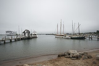
Vineyard Haven is a community within the town of Tisbury, Massachusetts, United States on the island of Martha's Vineyard. It is listed as a census-designated place (CDP) by the U.S. Census Bureau, with a population of 2,114 as of the 2010 census.

Nobska Light, originally called Nobsque Light, also known as Nobska Point Light is a lighthouse located near the division between Buzzards Bay, Nantucket Sound, and Vineyard Sound in the settlement of Woods Hole, Massachusetts on the southwestern tip of Cape Cod, Massachusetts. It overlooks Martha's Vineyard and Nonamesset Island. The light station was established in 1828, with the tower protruding above the keeper's house, and was replaced in 1876 by the current 42 foot tall iron tower. The light station was added to the National Register of Historic Places as Nobska Point Light Station in 1987.

West Chop Light is a lighthouse station located at the entrance of Vineyard Haven Harbor in Tisbury, Massachusetts, on the northern tip of West Chop, a few miles from the village of Vineyard Haven.

The Berkeley Street Historic District is a historic district on Berkeley Street and Berkeley Place in Cambridge, Massachusetts. It encompasses a neighborhood containing one of the greatest concentrations of fine Italianate and Second Empire houses in the city. It was listed on the National Register of Historic Places in 1982, with a substantial increase in 1986.

The Bigelow Street Historic District encompasses a uniform collection of 19th century houses on most of the length of Bigelow Street in Cambridge, Massachusetts, just northwest of Central Square. Bigelow Street was laid out in 1868, and the street was almost completely built out by 1874, resulting in a fairly uniform streetscape of Second Empire architecture. The district was added to the National Register of Historic Places in 1982.
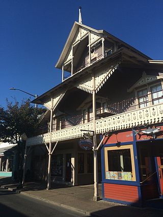
The Arcade is an historic building at 31 Circuit Avenue in Oak Bluffs, Massachusetts. Built in the early 1870s, it is one of the best preserved buildings on Circuit Ave, and is further locally significant as housing the offices of the Oak Bluffs Land and Wharf Company, which was responsible for much of the early development of the town of Oak Bluffs. The property was listed on the National Register of Historic Places in 1994.
The Gay Head–Aquinnah Town Center Historic District is a historic district encompassing the center of the American town of Aquinnah, Massachusetts. The district includes six contributing buildings and two monuments, based around the intersection of South and Church Streets in Aquinnah.

The West Chop Club Historic District is a historic district in Tisbury, Massachusetts, on the island of Martha's Vineyard. The district represents a well-preserved planned summer resort community of the late 19th century. Located in and around Iroquois Avenue, the district encompasses the northernmost portion of West Chop, a peninsula that separates Vineyard Sound and the sheltered waters of Vineyard Haven Harbor, an area that was developed by the West Chop Land Company in the 1880s. The land is now owned by the West Chop Land Trust and managed by the private West Chop Club. The district was listed on the National Register of Historic Places in 2007.

The Old Mill is an historic mill building at 690 Edgartown-West Tisbury Road in West Tisbury, Massachusetts, on the island of Martha's Vineyard. The current structure was built c. 1848, and occupies a site that has seen industrial use since the 17th century. The property is currently owned by the Martha's Vineyard Garden Club.
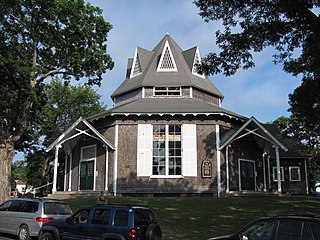
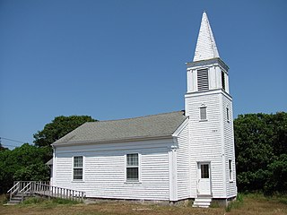
Union Chapel is an historic octagon-shaped church building in Oak Bluffs, on Martha's Vineyard, Massachusetts. The church was built in 1870 as a non-sectarian worship space in an area dominated by the Methodist summer camp meeting known as Wesleyan Grove. Acquired in 2002 by the nonprofit Martha's Vineyard Preservation Trust, the building continues to be used for nonsectarian religious services, and also serves as a community center and performing arts space.
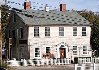
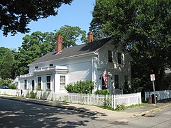
The Ritter House is an historic house on Beach Street in Vineyard Haven, Massachusetts, USA, and is listed on the National Register of Historic Places. The house is one of the few remaining Federal period buildings in Vineyard Haven. It has had a succession of occupants and uses, and as of 2007 served as a retail establishment.

The Cohasset Common Historic District is a historic district encompassing the historic town center of Cohasset, Massachusetts. It is centered on the town common, which is bounded by Highland Ave., N. Main St., William B. Long, Jr., Rd. and Robert E. Jason Road. The district was added in 1996 to the National Register of Historic Places.

The Craigville Historic District encompasses a historic religious camp meeting area in the Craigville section of Barnstable, Massachusetts, United States. It is centered on the junction of Lake Elizabeth Drive and Ocean Avenue, just west of Lake Elizabeth. The camp meeting was established in 1871 by the New England Convention of Christian Churches on land that was purchased from members of the Perry family. Along the grid of roads south of the main junction, gingerbread-decorated Gothic cottages were built over the following decades. The main tabernacle, an open-walled church, was built in 1887. The district was listed on the National Register of Historic Places in 1987.
The Prospect—Gaylord Historic District is a historic district encompassing a residential area built up mostly in the late 19th century just outside the central business district of Amherst, Massachusetts. Contributing properties include most of the houses on Prospect Street, which parallels Pleasant Street, as well as properties on Gaylord and Amity Streets running west from Prospect. These houses are generally in late Victorian styles such as Queen Anne, although some, for example a workman's house at 24 Gaylord Street, are in a more vernacular style. A central element of the district is the Hope Community Church, a historically African American church built in 1912 for a congregation whose history dates to 1869. Funds for its construction were raised in part through the efforts of W.E.B. Du Bois. The district was listed on the National Register of Historic Places in 1993.
The Central Square Historic District is a historic district encompassing the Central Square area of downtown Lynn, Massachusetts. The area is at the confluence of a number of city streets, and includes buildings that border on Central Avenue, Willow Street, Munroe Street, Lake Street, Almont Street. It is a small part of Lynn's "Burned District", a large area of the downtown that was destroyed by fire in 1889. One of the first buildings built after the fire, the Bergengren Block, stands at the corner of Union Street and Central Square. It also includes the Mowers' Block, listed on the National Register in 1982.

The Tashmoo Springs Pumping Station is a historic waterworks facility in Tisbury, Massachusetts, on the island of Martha's Vineyard. The pump station and associated works were first constructed by private interests in the 1880s to provide a reliable water supply for the burgeoning resort areas of Tisbury as well as the port of Vineyard Haven. The facilities were taken over by the town in the early 20th century, after which some alterations were made to accommodate technological improvements. Following a series of hurricanes in the mid-20th century, which highlighted the risks of the station's location and ability to provide reliable drinking water, the town abandoned the facility. Since then it has been largely abandoned, although it was used in the 1990s by a bottled water interest, and some work has been done to preserve the Late Victorian main pumping station building.

The Columbia Road–Devon Street Historic District encompasses a collection of brick residential apartment houses on Columbia Road in the Dorchester neighborhood of Boston, Massachusetts. Arrayed on the southeast side of the road near its junction with Devon Street are seven multistory buildings, constructed in the first two decades of the 20th century, when the area was developed as a streetcar suburb. An eighth building from the same period is located on the northwest side at the junction with Stanwood Street. These apartment blocks are typical of the speculative housing built at the time, with most of them built out of red brick laid in Flemish bond, with cast stone trim.