Williams, South Carolina

Last updated

Williams, South Carolina
SCMap-doton-Williams.PNG
Location of Williams, South Carolina
Coordinates: 33°2′3″N80°50′35″W / 33.03417°N 80.84306°W / 33.03417; -80.84306
Country United States
State South Carolina
County Colleton
Government
  MayorWill Evans
Area
[1]
  Total0.85 sq mi (2.19 km2)
  Land0.85 sq mi (2.19 km2)
  Water0.00 sq mi (0.00 km2)
Elevation
105 ft (32 m)
Population
 (2020) [2]
  Total98
  Density115.70/sq mi (44.66/km2)
Time zone UTC-5 (Eastern (EST))
  Summer (DST) UTC-4 (EDT)
ZIP code
29493
Area code(s) 843, 854
FIPS code 45-77785 [3]
GNIS feature ID1231926 [4]

Williams is a town in Colleton County, South Carolina, United States. The population was 117 at the 2010 census. [5]

Contents

History

The Tom Williams House was listed in the National Register of Historic Places in 1973. [6]

Geography

Williams is located in northern Colleton County at 33°2′3″N80°50′35″W / 33.03417°N 80.84306°W / 33.03417; -80.84306 (33.034076, -80.842928). [7] It is 16 miles (26 km) northwest of Walterboro, the county seat.

According to the United States Census Bureau, the town has a total area of 0.85 square miles (2.2 km2), all land. [5]

Demographics

Historical population
CensusPop.Note
1940 218
1950 25416.5%
1960 194−23.6%
1970 2013.6%
1980 2052.0%
1990 188−8.3%
2000 116−38.3%
2010 1170.9%
2020 98−16.2%
U.S. Decennial Census [8] [2]

As of the census [3] of 2000, there were 116 people, 48 households, and 33 families residing in the town. The population density was 147.5 inhabitants per square mile (57.0/km2). There were 59 housing units at an average density of 75.0 per square mile (29.0/km2). The racial makeup of the town was 53.45% White, 44.83% African American, 0.86% from other races, and 0.86% from two or more races. Hispanic or Latino of any race were 0.86% of the population.

There were 48 households, out of which 20.8% had children under the age of 18 living with them, 60.4% were married couples living together, 10.4% had a female householder with no husband present, and 29.2% were non-families. 25.0% of all households were made up of individuals, and 18.8% had someone living alone who was 65 years of age or older. The average household size was 2.42 and the average family size was 2.91.

In the town, the population was spread out, with 22.4% under the age of 18, 5.2% from 18 to 24, 19.8% from 25 to 44, 32.8% from 45 to 64, and 19.8% who were 65 years of age or older. The median age was 48 years. For every 100 females, there were 93.3 males. For every 100 females age 18 and over, there were 87.5 males.

The median income for a household in the town was $31,563, and the median income for a family was $33,333. Males had a median income of $24,821 versus $25,625 for females. The per capita income for the town was $17,691. There were 2.6% of families and 6.5% of the population living below the poverty line, including 6.1% of under eighteens and 4.3% of those over 64.

Related Research Articles

<span class="mw-page-title-main">Colleton County, South Carolina</span> County in South Carolina, United States

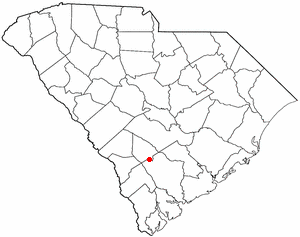
Colleton County is in the Lowcountry region of the U.S. state of South Carolina. As of the 2020 census, the population was 38,604. Its county seat is Walterboro. The county is named after Sir John Colleton, 1st Baronet, one of the eight Lords Proprietor of the Province of Carolina. After two previous incarnations, the current Colleton County was created in 1800.

<span class="mw-page-title-main">Dodge City, Alabama</span> Town in Alabama, United States

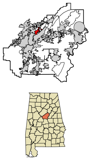
Dodge City is a town in Cullman County, Alabama, United States. At the 2020 census, the population was 548. It was incorporated in 1993.

<span class="mw-page-title-main">Argo, Alabama</span> Town in Alabama, United States

Argo is a town in Jefferson and St. Clair counties, Alabama, United States. It incorporated in 1987. At the 2020 census, the population was 4,368.

<span class="mw-page-title-main">Morris, Alabama</span> Town in Alabama, United States

Morris is a town in Jefferson County, Alabama, United States. It is north of the Birmingham suburb of Gardendale. It initially incorporated on September 19, 1885. At some point after 1910, its incorporation lapsed and it failed to appear on the census rolls beginning in 1920 through to 1950. It reincorporated on July 11, 1950. The population as of the 2010 U.S. Census was 1,859, up from 1,827 in 2000.

<span class="mw-page-title-main">Margaret, Alabama</span> City in Alabama, United States

Margaret is a city in St. Clair County, Alabama, United States. At the 2020 census, the population was 5,106. As of the 2010 census, the population is 4,428, an increase of 278.8%. Margaret incorporated in 1960 and became a city in October 2011.

<span class="mw-page-title-main">Springville, Alabama</span> City in Alabama, United States

Springville is a city in St. Clair County, Alabama, United States. It incorporated in December 1880. At the 2020 census the population was 4,786, up from 4,080 in 2010.

<span class="mw-page-title-main">Switz City, Indiana</span> Town in Indiana, United States

Switz City is a town in Fairplay and Grant townships, Greene County, Indiana, United States. The population was 293 at the 2010 census. It is part of the Bloomington, Indiana, Metropolitan Statistical Area.

<span class="mw-page-title-main">Pottawattamie Park, Indiana</span> Town in Indiana, United States

Pottawattamie Park is a town in Michigan Township, LaPorte County, Indiana, United States. The population was 235 at the 2010 census. It is included in the Michigan City, Indiana-La Porte, Indiana Metropolitan Statistical Area.

Deferiet is a village in Jefferson County, New York, United States. The population was 294 at the 2010 census. The village is named after settler Jenika de Ferriet.

<span class="mw-page-title-main">Wilmington Township, Mercer County, Pennsylvania</span> Township in Pennsylvania, United States

Wilmington Township is a township in Mercer County, Pennsylvania, United States. The population was 1,416 at the 2020 census, an increase from 1,415 in 2010.

<span class="mw-page-title-main">Lodge, South Carolina</span> Town in South Carolina, United States

Lodge is a town in Colleton County, South Carolina, United States. The population was 120 at the 2010 census.

<span class="mw-page-title-main">Smoaks, South Carolina</span> Town in South Carolina, United States

Smoaks is a town in Colleton County, South Carolina, United States. The population was 126 at the 2010 census.

<span class="mw-page-title-main">St. George, South Carolina</span> Town in South Carolina, United States

Saint George is a town in Dorchester County, South Carolina, United States. The population was 2,084 at the 2010 census, eight fewer than in 2000 census. It has been the county seat of Dorchester County since the latter's formation from Colleton County in 1897.

<span class="mw-page-title-main">Vance, South Carolina</span> Town in South Carolina, United States

Vance is a town in Orangeburg County, South Carolina, United States. The population was 170 at the 2010 census.

<span class="mw-page-title-main">Rocky Mound, Texas</span> Town in Texas, United States

Rocky Mound is a town in Camp County, Texas, United States. The population was 75 at the 2010 census, down from 93 at the 2000 census; in 2020, its population increased to 78.

<span class="mw-page-title-main">Harman, West Virginia</span> Town in West Virginia, United States

Harman is a town in Randolph County, West Virginia, United States. The population was 96 at the 2020 census.

<span class="mw-page-title-main">Coleman, Wisconsin</span> Village in Wisconsin, United States

Coleman is a village in Marinette County, Wisconsin, United States. The population was 726 at the 2020 census. It is part of the Marinette, WI–MI Micropolitan Statistical Area.

<span class="mw-page-title-main">Yemassee, South Carolina</span> Town in South Carolina, United States

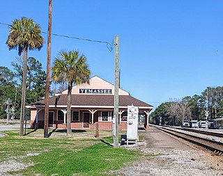
Yemassee is a small Lowcountry town in Beaufort and Hampton counties in the U.S. state of South Carolina. The population was 1,027 at the 2010 census. Yemassee is near the borders of Colleton and Jasper counties. The town is divided by the county line between Beaufort and Hampton counties, which follows the roadbed of the CSX railroad. Most of the town's population presently lies within Hampton County. As defined by the U.S. Census Bureau, the Beaufort County portion of Yemassee is included within the Hilton Head Island-Bluffton-Beaufort, SC Metropolitan Statistical Area. Yemassee hosts one of the few commercial breeding facilities of non-human primates in the entire United States, Alpha Genesis, Inc., which serves as a major employer for the town. Also, the Frank Lloyd Wright-designed Auldbrass Plantation house and outbuildings lie just outside the town limits of Yemassee.

<span class="mw-page-title-main">Williams Creek, Indiana</span> Town in Indiana, United States

Williams Creek is a town in Washington Township, Marion County, Indiana, United States. It is located about 9 miles (14 km) north of downtown Indianapolis. The population was 430 at the 2020 census. It has existed as an "included town" since 1970, when it was incorporated into Indianapolis as part of Unigov. It is part of Indianapolis, but retains a functioning town government under IC 36-3-1-11.

<span class="mw-page-title-main">Elbridge (village), New York</span> Village in New York, United States

Elbridge is a village. Located in the western part of the town of Elbridge in western Onondaga County, New York, United States, about 15 miles (24 km) west of Syracuse. It is part of the Syracuse Metropolitan Statistical Area. As of the 2020 census, the population was 921.

References

  1. "ArcGIS REST Services Directory". United States Census Bureau. Retrieved October 15, 2022.
  2. 1 2 "Census Population API". United States Census Bureau. Retrieved October 15, 2022.
  3. 1 2 "U.S. Census website". United States Census Bureau . Retrieved January 31, 2008.
  4. "US Board on Geographic Names". United States Geological Survey. October 25, 2007. Retrieved January 31, 2008.
  5. 1 2 "Geographic Identifiers: 2010 Census Summary File 1 (G001): Williams town, South Carolina". U.S. Census Bureau, American Factfinder. Archived from the original on February 13, 2020. Retrieved July 2, 2015.
  6. "National Register Information System". National Register of Historic Places . National Park Service. July 9, 2010.
  7. "US Gazetteer files: 2010, 2000, and 1990". United States Census Bureau. February 12, 2011. Retrieved April 23, 2011.
  8. "Census of Population and Housing". Census.gov. Retrieved June 4, 2015.