Williams Canyon, California

Last updated

Williams Canyon, California
USA California location map.svg
Red pog.svg
Williams Canyon
Usa edcp location map.svg
Red pog.svg
Williams Canyon
Coordinates: 33°43′44″N117°38′21″W / 33.72889°N 117.63917°W / 33.72889; -117.63917
CountryUnited States
StateCalifornia
County Orange
Area
[1]
  Total0.57 sq mi (1.47 km2)
  Land0.57 sq mi (1.47 km2)
  Water0.0 sq mi (0.0 km2)
Elevation
[2]
1,220 ft (370 m)
Time zone UTC-8 (Pacific (PST))
  Summer (DST) UTC-7 (PDT)
ZIP Code
92676 (Silverado)
Area code 949
FIPS code 06-85587
GNIS feature ID2812659 [2]

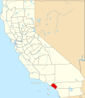
Williams Canyon is an unincorporated community and census-designated place (CDP) in the canyon of the same name in Orange County, California, United States. It is located in eastern Orange County on the western side of the Santa Ana Mountains, south of Silverado and north of Modjeska. Most of the community is within Cleveland National Forest.

Contents

Demographics

Historical population
CensusPop.Note
2020 93
U.S. Decennial Census [3]
2020 [4]

For statistical purposes, the United States Census Bureau first listed Williams Canyon as a census-designated place (CDP) in the 2020 census. [5]

2020 census

Williams Canyon CDP, California - Demographic Profile
Note: the US Census treats Hispanic/Latino as an ethnic category. This table excludes Latinos from the racial categories and assigns them to a separate category. Hispanics/Latinos may be of any race.
Race / Ethnicity (NH = Non-Hispanic)Pop 2020 [4] % 2020
White alone (NH)7075.27%
Black or African American alone (NH)00.00%
Native American or Alaska Native alone (NH)00.00%
Asian alone (NH)11.08%
Pacific Islander alone (NH)00.00%
Other race alone (NH)00.00%
Mixed race or Multiracial (NH)22.15%
Hispanic or Latino (any race)2021.51%
Total93100.00%

Related Research Articles

<span class="mw-page-title-main">Coto de Caza, California</span> Place in California, United States

Coto de Caza is a census-designated place (CDP) and guard-gated private community in Orange County, California, United States. The population was 14,710 at the 2020 census.

<span class="mw-page-title-main">North Tustin, California</span> Place in California, United States

North Tustin is an unincorporated community and census designated place (CDP) in Orange County, California. The population was 25,718 at the 2020 census, up from 24,917 in 2010. For statistical purposes, the United States Census Bureau has defined North Tustin as a census-designated place (CDP). It is both the largest CDP and largest unincorporated community in Orange County. The CDP's name was changed from Tustin Foothills in 2005. Located outside the city limits of Tustin, North Tustin has 92705 and 92780 ZIP Codes.

<span class="mw-page-title-main">Almanor, California</span> Census-designated place in California, United States

Almanor is a census-designated place (CDP) in Plumas County, California, United States. The population was 0 at the 2010 Census, but as of 2020, the population was reported as 3. Almanor is located 7 miles (11.3 km) south-southeast of Chester.

Lanham is an unincorporated community and census-designated place in Prince George's County, Maryland. As of the 2020 United States Census, it has a population of 11,282. The New Carrollton station as well as an Amtrak station are across the Capital Beltway in New Carrollton, Maryland. Doctors Community Hospital is located in Lanham.

<span class="mw-page-title-main">Trabuco Canyon, California</span> Unincorporated community in California, United States

Trabuco Canyon is a small unincorporated community located in the foothills of the Santa Ana Mountains in eastern Orange County, California, and lies partly within the Cleveland National Forest.

<span class="mw-page-title-main">Silverado, California</span> Unincorporated community in Orange County, California, United States

Silverado is an unincorporated community in Silverado Canyon, which is located in the Santa Ana Mountains in eastern Orange County, California. Portions of the town sit on a former Mexican land grant Rancho Lomas de Santiago. Silverado is located at the boundaries of Cleveland National Forest. The site is a California Historical Landmark, and is located near the village site of Puhú.

University is a census-designated place (CDP) and unincorporated community in Orange County, Florida, United States, east of Orlando. The community is centered around the University of Central Florida and includes a location on its south side known as University Park. It is part of the Orlando–Kissimmee–Sanford, Florida Metropolitan Statistical Area. As of 2020, the CDP had a population of 45,284.

<span class="mw-page-title-main">Modjeska Canyon, California</span> Unincorporated community in Orange County, California, United States

Modjeska Canyon is an unincorporated community and census designated place (CDP) on the western slope of the Santa Ana Mountains in eastern Orange County, California. It is a suburban community of several hundred residents, with a small park and a volunteer fire station. The ZIP Code is 92676, and the community is inside area code 714.

<span class="mw-page-title-main">Castella, California</span> Unincorporated community in California, United States

Castella is a small, unincorporated community and census-designated place (CDP) in the upper Sacramento Canyon of Shasta County, California. It is located 46 miles north of Redding on Interstate 5, and is home to Castle Crags State Park. Its population is 214 as of the 2020 census. It has a Chevron gas station/store and a post office. The ZIP Code is 96017. The community is inside area code 530.

Alta Sierra is an unincorporated community and census-designated place (CDP) in Kern County, California.

Bonadelle Ranchos is an unincorporated community and census-designated place (CDP) in Madera County, California, United States. It lies at an elevation of 338 feet (103 m). As of the 2020 census, it had a population of 5,497. Prior to 2020, the community was part of the Bonadelle Ranchos-Madera Ranchos CDP.

<span class="mw-page-title-main">Foresta, California</span> Unincorporated community in California, United States

Foresta is an unincorporated community and a census-designated place (CDP) in Mariposa County, California, within Yosemite National Park.

Centerville is an unincorporated community and census-designated place (CDP) in Shasta County, California, United States. Centerville is 6.5 miles (10.5 km) southwest of Redding.

Horizon West is a census-designated place (CDP) and unincorporated area in Orange County, Florida, United States. It is part of the Orlando–Kissimmee–Sanford, Florida Metropolitan Statistical Area. The population was 58,101 at the 2020 census.

Amador Pines is an unincorporated community and census-designated place (CDP) in Amador County, California, United States. It is located along California State Route 88, bordered to the south by Buckhorn and to the west by Lockwood. The Census Bureau first designated it as a CDP prior to the 2020 census for statistical purposes.

Eastern Goleta Valley is an unincorporated community and census-designated place (CDP) in Santa Barbara County, California, United States. It is located between Goleta to the west, Santa Barbara to the east, the Pacific Ocean to the south, and the Santa Ynez Mountains to the north and includes the communities of Noleta and Hope Ranch. For statistical purposes, the United States Census Bureau designated the area as a census-designated place (CDP) prior to the 2020 census. Prior to the incorporation of Goleta in 2002 within a narrower set of boundaries, the area was included in the Goleta CDP.

El Monte Mobile Village is an unincorporated community and census-designated place (CDP) comprising three census blocks in Tulare County, California, United States. It is on the north side of Avenue 416, 0.4 miles (0.64 km) west of the Dinuba city limits. The village was first listed as a CDP prior to the 2020 census.

Wildewood is a planned community and census-designated place (CDP) in St. Mary's County, Maryland, United States. It is in east-central St. Mary's County, 7 miles (11 km) east of Leonardtown, the county seat, and 58 miles (93 km) southeast of Washington, D.C. It is bordered to the east by the unincorporated community of California.

Ampere North is an unincorporated community and census-designated place (CDP) in Bloomfield Township, Essex County, in the U.S. state of New Jersey. It is in the southern corner of the township, bordered to the north by the Watsessing CDP, to the northeast by Silver Lake, to the southwest by East Orange, and to the southeast by Newark. Ampere Parkway runs through the center of the CDP, from Bloomfield Avenue at the northeast border of the community, south into the Ampere neighborhood in East Orange.

Carolina Meadows is a planned community and census-designated place (CDP) in Chatham County, North Carolina, United States. It was first listed as a CDP in the 2020 census with a population of 727.

References

  1. "2020 U.S. Gazetteer Files – California". United States Census Bureau. Retrieved March 31, 2021.
  2. 1 2 "Williams Canyon Census Designated Place". Geographic Names Information System . United States Geological Survey, United States Department of the Interior.
  3. "Decennial Census of Population and Housing by Decade". US Census Bureau.
  4. 1 2 "P2: Hispanic or Latino, and Not Hispanic or Latino by Race – 2020: DEC Redistricting Data (PL 94-171) - Williams Canyon CDP, California". United States Census Bureau. Retrieved January 26, 2024.
  5. "2020 Geography Changes". United States Census Bureau.