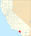
Trabuco Canyon, California

Last updated

Trabuco Canyon, California
Trabuco Canyon photo Don Ramey Logan.jpg
The "Wash" at Trabuco Canyon
Coordinates: 33°39′45″N117°35′25″W / 33.66250°N 117.59028°W / 33.66250; -117.59028
Country United States
State California
County Orange
Elevation
430 - 1,640 ft (−70 m)
Time zone UTC-8 (PST)
  Summer (DST) UTC-7 (PDT)
ZIP code
92678-92679
Area code 949

Trabuco Canyon (Trabuco, Spanish for "Blunderbuss") is a small unincorporated community located in the foothills of the Santa Ana Mountains in eastern Orange County, California, and lies partly within the Cleveland National Forest.

Contents

Trabuco Canyon is north of the town of Rancho Santa Margarita. Plano Trabuco Road leads from the top of the canyon south to Rancho Santa Margarita.

History

Trabuco is Spanish for blunderbuss, a type of shotgun. Some credit a Franciscan friar traveling with the Gaspar de Portolá Expedition in 1769 with the story that a blunderbuss was lost in the canyon, after which the area was named. A mission was originally to be built in the canyon, but was instead established in San Juan Capistrano. [1]

The Trabuco Adobe was built in 1810 next to the Acjachemen village of Alume that was also identified during the 1769 Portolá expedition, where Juan Crespí wrote, "we made camp close to a village of the most tractable and friendly heathens we have seen upon the whole way." [2]

John (Don Juan) Forster received a Mexican land grant in 1846 and established Rancho Trabuco. [3] The grant was bordered by Rancho Cañada de los Alisos on the west, and by Rancho Mission Viejo on the east. [4]

Trabuco Canyon was the site of attempts to mine tin in the early 1900s. Mining remains from this activity include: tunnels into the sides of the canyon (closed for public safety); the stone foundation of an ore-processing stamp mill; and several dams on the creek.

The Trabuco Canyon National Forest was established in 1907, which was quickly combined into the Cleveland National Forest in 1908. [5]

One of the last California grizzly bears was killed in Trabuco Canyon in 1908, a female bear thought to be the mate of the so-called "Monster of San Mateo." [6]

On October 21, 2007, a large wildfire started in Silverado Canyon and spread to Trabuco Canyon. The Canyon was evacuated by the Fire Department. [7]

On August 23, 2023, it was the site of a mass shooting. [8]

Updated news article as of 8-25-2023. Cook's Corner: 3 killed, 6 hospitalized in shooting at historic biker bar in Trabuco Canyon https://www.cbsnews.com/losangeles/news/cooks-corner-at-least-3-killed-6-hospitalized-in-shooting-at-historic-biker-bar-in-trabuco-canyon/

Features

Fourth of July features an old-fashioned parade of locals riding horses and pulling home-made floats. A local landmark is the Trabuco Oaks Steakhouse, which was a favorite restaurant of former President Richard Nixon. [9] [10]

The Vedanta Society of Southern California has the Ramakrishna Mission Monastery on 40 acres (160,000 m2) in the canyon, founded in 1942 by renowned author and philosopher Gerald Heard. [11] The Trabuco Canyon Community Church is located in the canyon also. [12]

Trabuco Canyon general store photo D Ramey Logan.jpg
Trabuco Canyon general store

Demographics

Historical population
CensusPop.Note
2020 1,020
U.S. Decennial Census [13]
2020 [14]

For statistical purposes, the United States Census Bureau first listed Trabuco Canyon as a census-designated place (CDP) prior to the 2020 census.

2020 census

Trabuco Canyon CDP, California - Demographic Profile
Note: the US Census treats Hispanic/Latino as an ethnic category. This table excludes Latinos from the racial categories and assigns them to a separate category. Hispanics/Latinos may be of any race.
Race / Ethnicity (NH = Non-Hispanic)Pop 2020 [14] % 2020
White alone (NH)71870.39%
Black or African American alone (NH)121.18%
Native American or Alaska Native alone (NH)20.20%
Asian alone (NH)626.08%
Pacific Islander alone (NH)00.00%
Other race alone (NH)70.69%
Mixed race or Multiracial (NH)615.98%
Hispanic or Latino (any race)15815.49%
Total1,020100.00%

See also

Related Research Articles

<span class="mw-page-title-main">Portola Hills, California</span> District of Lake Forest in California, United States

Portola Hills is a district in the city of Lake Forest, California in Orange County, United States. It was formerly an unincorporated community and census-designated place before it was annexed into Lake Forest in 2000. The population was 6,391 at the 2000 census. Portola Hills lies near Whiting Ranch Wilderness Park and Cleveland National Forest. Foothill Ranch is to the west, Rancho Santa Margarita in the southeast, Mission Viejo in the south, and the unincorporated regions of Silverado and Santiago Canyon to the north and northeast.

<span class="mw-page-title-main">Rancho Santa Margarita, California</span> City in California, United States

Rancho Santa Margarita is a city in Orange County, California, United States. One of Orange County's youngest cities, Rancho Santa Margarita is a master-planned community. The population was 47,853 at the 2010 census, up from 47,214 at the 2000 census. Although it is named for Rancho Santa Margarita y Las Flores, which was in San Diego County, the city limits fall within the borders of Rancho Mission Viejo. At 20 characters long, it is the longest city name in California.

<span class="mw-page-title-main">Santa Ana Mountains</span> Mountain range in California, United States

The Santa Ana Mountains are a short peninsular mountain range along the coast of Southern California in the United States. They extend for approximately 61 miles (98 km) southeast of the Los Angeles Basin largely along the border between Orange and Riverside counties.

Rancho Mission Viejo is an active 23,000 acres (9,300 ha) ranch and farm, habitat reserve, residential community, and census-designated place in South Orange County, California. Rancho Mission Viejo originated as a series of land grants to John Forster in 1845. The remaining part of Rancho Mission Viejo consists of a nearly 17,000-acre (6,900 ha) nature reserve and multiple residential communities slated to open in phases between 2010 and 2030. As of the 2020 census, it had a population of 10,378.

<span class="mw-page-title-main">Silverado, California</span> Unincorporated community in Orange County, California, United States

Silverado is an unincorporated community in Silverado Canyon, which is located in the Santa Ana Mountains in eastern Orange County, California. Portions of the town sit on a former Mexican land grant Rancho Lomas de Santiago. Silverado is located at the boundaries of Cleveland National Forest. The site is a California Historical Landmark, and is located near the village site of Puhú.

California's 40th congressional district is a congressional district in the U.S. state of California, encompassing Orange, San Bernardino, and Riverside counties. The district is currently represented by Republican Young Kim. It was one of 18 districts that would have voted for Joe Biden in the 2020 presidential election had they existed in their current configuration while being won or held by a Republican in 2022.

<span class="mw-page-title-main">San Juan Creek</span> River in Orange County, California, United States

San Juan Creek, also called the San Juan River, is a 29-mile (47 km) long stream in Orange and Riverside Counties, draining a watershed of 133.9 square miles (347 km2). Its mainstem begins in the southern Santa Ana Mountains in the Cleveland National Forest. It winds west and south through San Juan Canyon, and is joined by Arroyo Trabuco as it passes through San Juan Capistrano. It flows into the Pacific Ocean at Doheny State Beach. State Route 74, the Ortega Highway, crosses the Santa Ana Mountains via San Juan Canyon.

Santiago Canyon is a canyon and unincorporated community in South Orange County, California. According to the 2000 census, Santiago Canyon has several hundred residents living within its borders. Trabuco Canyon, Silverado Canyon, Modjeska Canyon and Williams Canyon are tributaries of Santiago Canyon. Santiago Creek flows northwest from the canyon, then west into the Santa Ana River. Neighborhoods in Santiago Canyon include Santiago Canyon Estates and Falcon View Estates. The landmark Cook's Corner motorcycle restaurant is also located within Santiago Canyon.

<span class="mw-page-title-main">Cook's Corner</span> Building in California, United States

Cook's Corner is an Orange County, California bar built in 1884 that is popular with motorcyclists. It is located between the city of Lake Forest and the unincorporated community of Silverado. Cook's Corner is situated in Trabuco Canyon, California at the intersection of Santiago Canyon Road and Live Oak Canyon Road.

<span class="mw-page-title-main">Santiago Fire</span> 2007 arson wildfire in eastern Orange County, California, US

The Santiago Fire was a wildfire located near Santiago Canyon in Orange County, California, U.S., and one of thirty California wildfires of October 2007. The fire was intentionally started.

<span class="mw-page-title-main">Arroyo Trabuco</span> Major tributary of San Juan Creek in Orange County, California

Arroyo Trabuco is a 22-mile (35 km)-long stream in coastal southern California in the United States. Rising in a rugged canyon in the Santa Ana Mountains of Orange County, the creek flows west and southwest before emptying into San Juan Creek in the city of San Juan Capistrano. Arroyo Trabuco's watershed drains 54 square miles (140 km2) of hilly, semi-arid land and lies mostly in Orange County, with a small portion extending northward into Riverside County. The lower section of the creek flows through three incorporated cities and is moderately polluted by urban and agricultural runoff.

<span class="mw-page-title-main">Santiago Creek</span> River in California, United States

Santiago Creek is a major watercourse in Orange County in the U.S. state of California. About 34 miles (55 km) long, it drains most of the northern Santa Ana Mountains and is a tributary to the Santa Ana River. It is one of the longest watercourses entirely within the county. The creek shares its name with Santiago Peak, at 5,687 ft (1,733 m) the highest point in Orange County, on whose slopes its headwaters rise.

<span class="mw-page-title-main">Bell Canyon</span> River in California, USA

Bell Canyon is a major drainage of the Santa Ana Mountains in Orange County, California in the United States. Bell Creek flows about 14.4 miles (23.2 km) in a southerly direction to its confluence with San Juan Creek. The Bell Canyon drainage is located to the east and parallel to Cañada Gobernadora, and to the south of Trabuco Creek. After Trabuco Creek, it is the second largest tributary of San Juan Creek in terms of length and its watershed area of 26 square miles (67 km2).

<span class="mw-page-title-main">O'Neill Regional Park</span> Park in Orange County, United States

O'Neil Regional Park is a major regional park and greenway in eastern Orange County, California, United States, located along Trabuco Creek and Live Oak Canyon. The park encompasses 4,500 acres (1,800 ha) of canyon and riparian zone habitat, and includes campgrounds and trails for hiking, biking and horseback riding.

Rancho Trabuco was a 22,184-acre (89.78 km2) Mexican land grant in present-day Orange County, California. The five square league grant consisted of two square leagues given in 1841 by Governor Juan B. Alvarado to Santiago Argüello plus three square leagues given in 1846 by Governor Pío Pico to John Forster. The name "trabuco" means "blunderbuss" in Spanish. The grant extended along Trabuco Creek and Trabuco Canyon, and encompassed present-day Coto de Caza. The grant was bordered by Rancho Cañada de los Alisos on the west, and by Rancho Mission Viejo on the east.

<span class="mw-page-title-main">Trabuco Peak</span> Stream in the American state of California

Trabuco Peak is a 4,607-foot (1,404 m) summit in the Santa Ana Mountains on the border of Orange and Riverside Counties, California, about halfway between Rancho Santa Margarita and Lake Elsinore. The mountain sits on the divide between Arroyo Trabuco on the west and the Temescal Creek valley on the east. Situated in the Cleveland National Forest, it is the highest summit in the Santa Anas south of Santiago Peak.

Los Pinos Peak is a 4,455-foot (1,358 m) summit in the Santa Ana Mountains in Orange County, California, about 8 miles (13 km) east of Rancho Santa Margarita. Los Pinos is the southernmost peak above 4,000 feet (1,200 m) in the Santa Anas, and provides extensive views south towards San Diego and the Pacific Ocean as well as views of the San Jacinto Mountains and San Bernardino Mountains in the east. The summit rises rather prominently above the main crest of the Santa Anas and is conspicuously visible from much of southern Orange County, although its actual topographic prominence is only about 610 feet (186 m).

The Municipal Water District of Orange County, commonly known by the acronym MWDOC, is a wholesale water provider, water resource development and planning agency., water-centric information, education, emergency planning, and conservation resource hub for nearly 3.2 millionOrange County, California residents, and businesses. Local water supply sources meet only about half of the region's total water needs. To fulfill the remaining demand, MWDOC buys imported water from the California State Water Project in northern California and the Colorado River through the Metropolitan Water District of Southern California (Metropolitan). MWDOC delivers water to its 27 member agencies - made up of both water districts and city water departments - who then, in turn, provide retail water service to the public.

<span class="mw-page-title-main">Alume</span> Former Acjachemen village in California

Alume was a large Acjachemen village located between Trabuco Creek and Tijeras Creek at Rancho Santa Margarita, California. The village was also recorded as Alaugna and as El Trabuco in San Juan Capistrano mission records, and is also referred to as Alauna, Aluna, and Alona.

<span class="mw-page-title-main">2023 Trabuco Canyon shooting</span> Mass shooting in Trabuco Canyon, California, U.S.

On August 23, 2023, a mass shooting occurred at the Cook's Corner bar in Trabuco Canyon, California, United States. Three people were killed and six others wounded before the gunman, 59-year-old ex-Ventura police officer John Snowling, was shot and killed by responding police officers.

References

  1. Moodian, Michael A. (2010). Rancho Santa Margarita. Charleston, SC: Arcadia Pub. ISBN   978-0-7385-8004-3. OCLC   464595759.
  2. Brigandi, Phil (2013). Orange County chronicles. Charleston. ISBN   978-1-62584-588-7. OCLC   914181947.{{cite book}}: CS1 maint: location missing publisher (link)
  3. Diseño del Rancho Trabuco
  4. Spanish and Mexican Ranchos of Orange County Archived 2011-07-26 at the Wayback Machine
  5. Newland, James D. (2008). Cleveland National Forest. Charleston, SC: Arcadia Pub. p. 23. ISBN   978-0-7385-5804-2. OCLC   212842956.
  6. Neely, Nick (2019). Alta California : from San Diego to San Francisco, a journey on foot to rediscover the Golden State. Berkeley, California. ISBN   978-1-64009-166-5. OCLC   1112702743.{{cite book}}: CS1 maint: location missing publisher (link)
  7. "OCFA". Archived from the original on October 27, 2007.
  8. Rodriguez, Matthew; Gile, Michelle (August 23, 2023). "Cook's Corner: 4 killed, 6 hospitalized in shooting at historic biker bar in Trabuco Canyon - CBS Los Angeles". CBS News . Retrieved August 23, 2023.
  9. "Trabuco Oaks Steak House - Orange County Restaurant Reviews - FoodieView". Archived from the original on June 10, 2010. Retrieved January 22, 2010.
  10. Trabuco Oaks Steak House - Rancho Santa Margarita - Trabuco Canyon | Urbanspoon
  11. http://www.vedanta.org/vssc/centers/trabuco.html Archived 2010-06-20 at the Wayback Machine Vedanta Society: Trabuco Canyon . accessed 8/20/2010
  12. Trabuco Canyon Community Church Archived 2008-10-31 at the Wayback Machine ,
  13. "Decennial Census of Population and Housing by Decade". US Census Bureau.
  14. 1 2 "P2: Hispanic or Latino, and Not Hispanic or Latino by Race – 2020: DEC Redistricting Data (PL 94-171) - Trabuco Canyon CDP, California". United States Census Bureau. Retrieved January 26, 2024.

Updated news article as of 8-25-2023. Cook's Corner: 3 killed, 6 hospitalized in shooting at historic biker bar in Trabuco Canyon https://www.cbsnews.com/losangeles/news/cooks-corner-at-least-3-killed-6-hospitalized-in-shooting-at-historic-biker-bar-in-trabuco-canyon/