
Ebor is a village on Waterfall Way on the Northern Tablelands in New South Wales, Australia. It is situated about 80 km (50 mi) east of Armidale and about a third of the way between Armidale and the coast. Dorrigo to the east is 46 kilometres (29 mi) away with the Coffs Coast 55 kilometres (34 mi) away along Waterfall Way. In the 2016 census, Ebor's zone had a population of 166.

The Bundjalung National Park is a 210-square-kilometre (81 sq mi) national park located on the north coast of New South Wales, Australia, 554 kilometres (344 mi) north-east of Sydney. It protects an area of coastal plain, heathland and solitary beaches between the towns of Iluka and Evans Head.

Coolah Tops is a national park located in New South Wales, Australia, 258 kilometres (160 mi) northwest of Sydney, established on 5 July 1996. It is managed by the New South Wales National Parks and Wildlife Service. Its World Conservation Union category is II. It is situated 30 kilometres (19 mi) east of Coolah in the Liverpool Range, on the Coolah Creek Road.
Wollumbin National Park is a national park located in northern New South Wales, Australia, 642 kilometres (399 mi) north of Sydney near the border with the state of Queensland. It surrounds Mount Warning, part of a remnant caldera of a much larger extinct volcano. The park is administered by the NSW National Parks and Wildlife Service. The park is part of the Scenic Rim Important Bird Area, identified as such by BirdLife International because of its importance in the conservation of several species of threatened birds.

The Nightcap National Park is a national park situated within the Nightcap Range in the Northern Rivers region of New South Wales, Australia. The 8,080-hectare (20,000-acre) park was created in April 1983 and is situated 35 kilometres (22 mi) north of Lismore. The national park is classed by the IUCN World Commission on Protected Areas as Category II and is part of the Shield Volcano Group of the World Heritage Site Gondwana Rainforests of Australia inscribed in 1986 and added to the Australian National Heritage List in 2007. The park was severely burned during the 2019-2020 Australian brushfire season, and its biodiversity has likely been decimated.

The City of Shoalhaven is a local government area in the south-eastern coastal region of New South Wales, Australia. The area is about 200 kilometres (120 mi) south of Sydney. The Princes Highway passes through the area, and the South Coast railway line traverses the northern section, terminating at Bomaderry. At the 2016 census, the population was 99,650.

Coffs Harbour is a city on the Mid North Coast of New South Wales, Australia, 540 km (340 mi) north of Sydney, and 390 km (240 mi) south of Brisbane. It is one of the largest urban centres on the North Coast, with an estimated population of 71,822 in 2018.

Northern Rivers is the most north-easterly region of the Australian state of New South Wales, located between 590 kilometres (370 mi) and 820 kilometres (510 mi) north of the state capital, Sydney, and encompasses the catchments and fertile valleys of the Clarence, Richmond, and Tweed rivers. It extends from Tweed Heads in the north to the southern extent of the Clarence river catchment which lies between Grafton, and Coffs Harbour, and includes the main towns of Tweed Heads, Byron Bay, Ballina, Kyogle, Lismore, Casino and Grafton. At its most northern point, the region is 102 kilometres (63 mi) south south–east of the Queensland capital, Brisbane.

Port Kembla is a suburb of Wollongong 8 km south of the CBD and part of the Illawarra region of New South Wales. The suburb comprises a seaport, industrial complex, a small harbour foreshore nature reserve, and a small commercial sector. It is situated on the tip of Red Point, first European sighting by Captain James Cook in 1770. The name "Kembla" is Aboriginal word meaning "plenty [of] wild fowl".

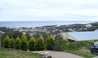
Tathra is a seaside town on the Sapphire Coast found on the South Coast, New South Wales, Australia. As at the 2016 census, Tathra had a population of 1,675.
Mount Warning, a mountain in the Tweed Range in the Northern Rivers region of New South Wales, Australia, was formed from a volcanic plug of the now-gone Tweed Volcano. The mountain is located 14 kilometres (9 mi) west-south-west of Murwillumbah, near the border between New South Wales and Queensland. Lieutenant James Cook saw the mountain from the sea and named it Mount Warning.
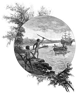
Kurnell is a suburb in Sydney, in the state of New South Wales, Australia. It is 21.4 kilometres (13.3 mi) south of the Sydney central business district, in the local government area of the Sutherland Shire along the east coast. Cronulla and Woolooware are the only adjacent suburbs. La Perouse is located opposite, on the northern headland of Botany Bay. The Cronulla sand dunes are on the south eastern headland of Botany Bay. The eastern side of the peninsula is part of Botany Bay National Park, and Towra Point Nature Reserve is located on the western side of the suburb.

One Mile is a suburb of the Port Stephens local government area in the Hunter Region of New South Wales, Australia. The Worimi people are the traditional owners of the Port Stephens area. The suburb is semi-rural with a small urban settlement, several eco-resorts and back-packer accommodation to the west of Gan Gan Road. On the beach side there is a residential land-lease community and three tourist parks. The parks, two of which have licensed restaurants, are positioned to provide quick access to the suburb's two beaches. Since late 2017 Port Stephens Koala Hospital has been operating in the grounds of Treescape resort and is currently undergoing a major expansion.
Boat Harbour is a suburb of the Port Stephens local government area in the Hunter Region of New South Wales, Australia. The main population centre of the suburb is the village also known as Boat Harbour. Both lie adjacent to the bay after which they were named. The traditional owners the land are Worimi people.

The 1994 eastern seaboard fires were significant Australian bushfires that occurred in New South Wales, Australia during the bushfire season of 1993–1994. Some 20,000 firefighters were deployed against some 800 fires throughout the state, and along the coast and ranges from Batemans Bay in the south to the Queensland border in the north, including populated areas of the city of Sydney, the Blue Mountains and the Central Coast. The fires caused mass evacuations of many thousands of people, claimed four lives, destroyed some 225 homes and burned out 800,000 hectares of bushland. The firefighting effort raised in response was one of the largest seen in Australian history.

Park Beach is a suburb of Coffs Harbour, northern New South Wales, located in the north eastern part of the town. It has a population of around 5,000 which swells during summer as it is a coastal tourist destination containing many motels, backpackers and other forms of accommodation. The suburb of Park Beach is generally considered to be the area within the Ocean Parade and Orlando Street intersection at the south, the Orlando Street and Woolgoolga Road intersection, the turnoff from the Pacific Highway onto Macauleys Headland Drive, and the southern end of the Coffs Coast Regional Park.
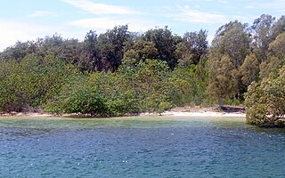
The Ukerabagh Island is a river island, contained within the Ukerabagh Island Nature Reserve, a protected nature reserve, that is located in the mouth of the Tweed River, in the Northern Rivers region of New South Wales in eastern Australia. The 125-hectare (310-acre) reserve is situated near Tweed Heads and 1 kilometre (0.62 mi) south of a section that defines the border between the states of New South Wales and Queensland. The island and reserve is an important site for coastal birds.
Stokers Siding is a village located in the Tweed Shire in north-eastern New South Wales, Australia, near the Burringbar Range and Mount Warning. It has been described as an "idyllic village".
Ingalba, Big Bush and Pucawan Nature Reserves are three Nature Reserves situated to the west of Temora, New South Wales. Ingalba Nature Reserve is situated 10 kilometres west of Temora and Pucawan Nature Reserve a further 6 km west. Big Bush Nature Reserve is 15 kilometres northwest of Temora. All three reserves are located within Temora Shire. They are managed concurrently by the New South Wales Parks and Wildlife Service. The reserves are linked by corridors of vegetation in adjacent private land and along roads and Travelling Stock Routes.
Broken Head is a coastal feature (promontory/headland) and suburb located in the Northern Rivers region of New South Wales, Australia, approximately 9 km south of Cape Byron, the easternmost point of Australia, the closest town being Byron Bay. Immediately adjacent is the 98-hectare (240-acre) Broken Head Nature Reserve which contains an intact segment of littoral rainforest. The suburb of Broken Head contained a population of 225 at the 2011 national census, and in addition supports some tourist accommodation and a campsite. The area is noted for its Aboriginal culture, rainforest walks, whale watching and fishing from pristine beaches, and it is also highly regarded as a surfing locality. The Broken Head Holiday Park is currently administered by the indigenous Arakwal people, having been passed to their control by the New South Wales Crown Lands Department in 2009.
