Yevpatoria Municipality

Last updated • 2 min readFrom Wikipedia, The Free Encyclopedia
Yevpatoria City Municipality
Євпаторійська міськрада
Flag Eupatoria.svg
COA of Evpatoria.svg
Karta-skhema Kryma Evpatoriiskii gorsovet.png
Location of the municipality (dark blue) in Crimea
Coordinates: 45°12′13″N33°21′41″E / 45.20361°N 33.36139°E / 45.20361; 33.36139
Country
Republic Crimea
EstablishedFebruary 11, 1963
Admin. center Yevpatoria
Subdivisions
List
  • 1 cities
  • 3 towns
  • 0 villages
Government
  City MayorAndriy Danylenko [1]
Area
  Total65 km2 (25 sq mi)
Population
 (2013)
  Total119,258
  Density1,800/km2 (4,800/sq mi)
Time zone UTC+3 (MSK)
Dialing code +380 6569
Website evp.rk.gov.ru

The Yevpatoria City Municipality (Ukrainian : Євпаторійська міськрада, translit. Yevpatoriis'ka mis'krada) is one of the 25 regions of the Autonomous Republic of Crimea, a territory recognized by almost all countries as part of Ukraine but occupied by Russia as the Republic of Crimea. The region is located on the western coast of Crimea on the Black Sea's shore. Its administrative center is the city of Yevpatoria. Population: 119,258 (2014 Census). [2]

Contents

Name

The Yevpatoria City Municipality is also known by its two other native official names; in Russian as Evpatoriyskiy gorsovet (Евпаторийский горсовет), and in Crimean Tatar as Kezlev şeer şurası. Colloquially, the municipality is known as "the territory governed by the Yevpatoria City Council (Ukrainian : Євпаторійська міська рада).

History

The Yevpatoria City Municipality was formed on February 11, 1963 when the territory of the Yevpatoria Raion was absorbed into the already existing Saky Raion. At that time, the Yevpatoria municipality was established with the city of Yevpatoria governing the territory. The municipality was reestablished on May 1, 1990.[ citation needed ]

Demographics

The Yevpatoria City Municipality's population was 117,565 as of the 2001 Ukrainian Census [3] and 123,505 as of April 1, 2013. [4]

The region's nationality composition results of the 2001 census was as follows:

All of the other nationalities took up the remaining 4.9 percent. [5]

Administrative and municipal status

Within the framework of administrative divisions of Russia, Yevpatoria is, together with a number of urban and rural localities, incorporated separately as the town of republican significance of Yevpatoriya—an administrative unit with the status equal to that of the districts. [6] As a municipal division, the town of republican significance of Yevpatoriya is incorporated as Yevpatoriya Urban Okrug. [7]

Within the framework of administrative divisions of Ukraine, Yevpatoria is incorporated as the town of republican significance of Yevpatoria. [8] Ukraine does not have municipal divisions.

Besides the city of Yevpatoria which serves as the region's administrative center, the Yevpatoria municipality also includes three urban-type settlements:

In July 2020, the Verkhovna Rada approved an administrative reform in Crimea AR Crimea 2020 subdivisions.jpg
In July 2020, the Verkhovna Rada approved an administrative reform in Crimea

2020 Ukrainian Administrative Reform

In July 2020, Ukraine conducted an administrative reform throughout its de jure territory. This included Crimea, which was at the time occupied by Russia, and is still ongoing as of October 2023. Crimea was reorganized from 14 raions and 11 municipalities into 10 raions, with municipalities abolished altogether.

Yevpatoria Municipality was abolished, and its territories to become a part of Yevpatoria Raion, but this has not yet been implemented due to the ongoing Russian occupation. [9]

Related Research Articles

<span class="mw-page-title-main">Yevpatoria</span> City in Crimea

Yevpatoria is a city in Western Crimea, north of Kalamita Bay. Yevpatoria serves as the administrative center of Yevpatoria Municipality, one of the districts (raions) into which Crimea is divided. It had a population of 105,719 .

<span class="mw-page-title-main">Kirovske Raion</span> Raion in Crimea, Ukraine

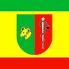
Kirovske Raion was one of the 25 regions of the Autonomous Republic of Crimea until 2020. The raion's administrative centre is the urban-type settlement of Kirovske. Population: 50,834 .

<span class="mw-page-title-main">Yalta Municipality</span> Municipality in Crimea, Ukraine

Yalta City Municipality, officially "the territory governed by the Yalta city council", also known as Greater Yalta is one of the 25 regions of the Autonomous Republic of Crimea, a territory recognized by a majority of countries as part of Ukraine but forcibly incorporated into Russia after Russia invaded Ukraine in 2014.

Feodosia City Municipality, officially "the territory governed by the Feodosia city council", is one of the 25 regions of the Autonomous Republic of Crimea, a territory recognized by a majority of countries as part of Ukraine and incorporated by Russia as the Republic of Crimea. Population: 100,962 .

<span class="mw-page-title-main">Alushta Municipality</span> Municipality in Crimea

Alushta City Municipality, officially "the territory governed by the Alushta city council", also known as Greater Alushta is one of the 25 regions of the Autonomous Republic of Crimea, a territory recognized by a majority of countries as part of Ukraine but incorporated by Russia as the Republic of Crimea. Population: 52,318 .

<span class="mw-page-title-main">Sudak Municipality</span> Municipality in Crimea, Disputed:

Sudak City Municipality, officially "the territory governed by the Sudak city council" is one of the 25 regions of the Crimean peninsula, currently subject to a territorial dispute between the Russian Federation and Ukraine. Population: 32,278 .

Armiansk City Municipality is an administrative territorial entity of the Autonomous Republic of Crimea. Population: 24,415 .

<span class="mw-page-title-main">Raions of Ukraine</span> Second-level administrative divisions of Ukraine

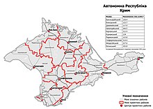
A raion, often translated as district, is the second-level administrative division in Ukraine. Raions were created in a 1922 administrative reform of the Soviet Union, to which Ukraine, as the Ukrainian Soviet Socialist Republic, belonged.

<span class="mw-page-title-main">Saky Municipality</span> Municipality in Republic of Crimea

The Saky City Municipality is one of the 25 regions of the Crimean Peninsula, internationally recognized as part of Ukraine, but currently occupied by Russia. The region is located on the western coast of Crimea on the Black Sea's shore. Its administrative centre is the city of Saky. In 2014, the population stood at 25,146.

<span class="mw-page-title-main">Saky Raion</span> Raion in Crimea, Ukraine

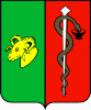
Saky Raion is one of the 25 regions of the Autonomous Republic of Crimea, a territory recognized by a majority of countries as part of Ukraine and incorporated by Russia as the Republic of Crimea. Its administrative center is the city of Saky, which is not a part of the district. Population: 76,489 .

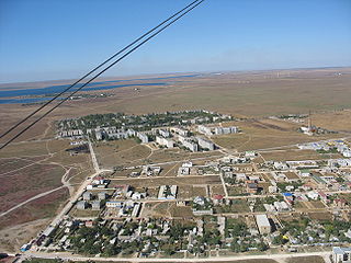
Oktiabrske, known by Ukrainian authorities as Biiuk-Onlar is an urban-type settlement in the Krasnohvardiiske Raion (district) of the Autonomous Republic of Crimea, a territory illegally occupied by Russia as the Republic of Crimea since 2014. As of the 2001 Ukrainian Census, its population is 10,910. Current population: 10,218 .

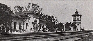
Nyzhniohirskyi or Nizhnegorsky, is an urban-type settlement in the Autonomous Republic of Crimea, a territory recognized by a majority of countries as part of Ukraine and occupied by Russia as the Republic of Crimea. The town also serves as the administrative center of the Nyzhnohirskyi Raion (district), housing the district's local administration buildings.

<span class="mw-page-title-main">Hvardiiske, Simferopol Raion</span> Urban-type settlement

Hvardiiske is an urban-type settlement in Simferopol Raion of the Autonomous Republic of Crimea, a territory recognized by a majority of countries as part of Ukraine and incorporated by Russia as part of the Republic of Crimea since the 2014 annexation of Crimea. Population: 12,589 .

Zaozerne is an urban-type settlement in the Yevpatoria municipality of the Autonomous Republic of Crimea, a territory recognized by a majority of countries as part of Ukraine and incorporated by Russia as the Republic of Crimea. Population: 4,332 ; 4,161 as of the 2001 Ukrainian Census, and 4,940 in 2011.

<span class="mw-page-title-main">Novoozerne</span> Urban-type settlement in Crimea

Novoozerne is an urban-type settlement in the Yevpatoria municipality of the Autonomous Republic of Crimea, a territory recognized by a majority of countries as part of Ukraine and since 2014 occupied and incorporated by Russia as the Republic of Crimea. Population: 4,998 ; 6,108 as of the 2001 Ukrainian Census, and 7,242 in 2011.

<span class="mw-page-title-main">Myrnyi</span> Urban-type settlement in Crimea, Ukraine

Myrnyi is an urban-type settlement in the Yevpatoria municipality of the Autonomous Republic of Crimea, a territory recognized by a majority of countries as part of Ukraine and incorporated by Russia as the Republic of Crimea. The town's population was 4,052 as of the 2001 Ukrainian Census. Population: 4,209 .

<span class="mw-page-title-main">Autonomous Republic of Crimea</span> De jure autonomous republic of Ukraine

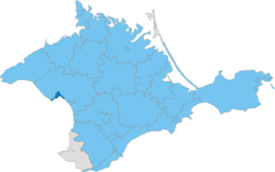
The Autonomous Republic of Crimea is an administrative division of Ukraine encompassing most of Crimea that was unilaterally annexed by Russia in 2014. The Autonomous Republic of Crimea occupies most of the peninsula, while the City of Sevastopol occupies the rest.

<span class="mw-page-title-main">Administrative divisions of Crimea</span>

The Crimean Peninsula is a disputed area which as a result of the annexation of Crimea by the Russian Federation is controlled and recognized by Russia as the Republic of Crimea, a federal subject of Russia. At the same time, Ukraine and most UN countries around the world recognize the territory as the Autonomous Republic of Crimea, a part of Ukraine.

<span class="mw-page-title-main">Kurpaty</span> Urban-type settlement in Crimea

Kurpaty is an urban-type settlement in the Yalta Municipality of the Autonomous Republic of Crimea, a territory recognized by a majority of countries as part of Ukraine and annexed by Russia as the Republic of Crimea.

References

  1. "Yevpatoria City Council". Regions of Ukraine and their Structure (in Ukrainian). Verkhovna Rada of Ukraine . Retrieved 17 June 2013.
  2. Russian Federal State Statistics Service (2014). "Таблица 1.3. Численность населения Крымского федерального округа, городских округов, муниципальных районов, городских и сельских поселений" [Table 1.3. Population of Crimean Federal District, Its Urban Okrugs, Municipal Districts, Urban and Rural Settlements]. Федеральное статистическое наблюдение «Перепись населения в Крымском федеральном округе». ("Population Census in Crimean Federal District" Federal Statistical Examination) (in Russian). Federal State Statistics Service . Retrieved January 4, 2016.
  3. "City of Yevpatoria". Regions of Ukraine and their Structure (in Ukrainian). Verkhovna Rada of Ukraine . Retrieved 17 June 2013.
  4. "Results of the population count on April 1, 2013 and the average for January-March 2013". Main Department of Statistics of the Autonomous Republic of Crimea (in Ukrainian). Archived from the original on 12 December 2013. Retrieved 18 June 2013.
  5. "Linguistic composition of the population". Main Department of Statistics of the Autonomous Republic of Crimea (in Russian). Archived from the original on 2 July 2013. Retrieved 18 June 2013.
  6. Law of the Republic of Crimea #35-ZRK
  7. Law of the Republic of Crimea #15-ZRK
  8. Чисельність наявного населення України (in Ukrainian). State Service of Statistics. Retrieved 8 August 2014.
  9. "Про утворення та ліквідацію районів". Офіційний вебпортал парламенту України (in Ukrainian). Retrieved 2023-10-16.