Yokefleet

Last updated

Yokefleet
Main Street, Yokefleet.JPG
Looking west on Greenoak Lane, Yokefleet
East Riding of Yorkshire UK location map.svg
Red pog.svg
Yokefleet
Location within the East Riding of Yorkshire
OS grid reference SE819242
  London 155 mi (249 km)  S
Civil parish
Unitary authority
Ceremonial county
Region
Country England
Sovereign state United Kingdom
Post town GOOLE
Postcode district DN14
Dialling code 01430
Police Humberside
Fire Humberside
Ambulance Yorkshire
UK Parliament
List of places
UK
England
Yorkshire
53°42′31″N0°45′37″W / 53.708660°N 0.760242°W / 53.708660; -0.760242

Yokefleet (also known as Yorkfleet) [1] is a hamlet and former civil parish, now in the parish of Blacktoft, in the East Riding of Yorkshire, England. A very small part of Yokefleet is in the civil parish of Laxton. It is situated on the north bank of the River Ouse, downstream from York, Selby and Goole. In 1931 the parish had a population of 102. [2]

Contents

Yokefleet is approximately 4 miles (6.4 km) south-east from Howden and 20 miles (32 km) south-east from the county town of York. Yokefleet lies within the Parliamentary constituency of Haltemprice and Howden an area that mainly consists of middle class suburbs, towns and villages. The area is affluent, placed as the 10th most affluent in the country in a Barclays Private Clients survey, [3] and has one of the highest proportions of owner-occupiers in the country. [4]

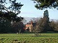
Yokefleet Hall is a Grade II listed mansion house of Victorian design by architect Cuthbert Brodrick. [5] The hall is on the eastern edge of the hamlet and the current house was built between 1868 and 1874 according to the York Georgian Society. [6]

History

Yokefleet is one of the ancient manors mentioned in the Domesday Book of 1086. The original Manor House was located on a moated site in the hamlet. [7]

In 1823 Yokefleet had a population of 199, which included a yeoman farmer, a corn miller, and a cattle dealer. It contained a windmill which served "as a mark for sailors to navigate the river". [8] By 1831 Yokefleet population had dropped to 190, within a parish area of 950 acres (384 ha) which included ecclesiastical land and Walling Fen. The land mainly belonged to the Empson family who were impropriators lay persons as patrons of incumbent clergy. There was a Wesleyan chapel. Occupations by this time included seven farmers, a school teacher for the local school, a corn miller, tailor, and two shoemakers, one of whom was a shopkeeper. [9] A descendant of the Empson family, born at Yokefleet Hall, was literary critic and poet Sir William Empson (1906 – 1984). [10] [11]

Prince Philip named his horse after Yokefleet and was seen having trouble controlling the horse at Horse Guards Parade, London in 1953. [12]

In early December 2013 Yokefleet, among other regional settlements was subject to flooding due to a tidal surge on the Ouse the largest in 60 years. According to the Environment Agency, damage caused would have been worse had it not been for the flood defences in place across the region. A 2014 Flood Investigation Report from East Riding of Yorkshire Council recommended that affected property owners should "develop a personal flood plan". [13] [14] However, improved flood defences are likely to be introduced across the region, including the significant raising of the river bank in order to ensure such flooding does not reoccur. The Environment Agency expressed confidence in such flood defences being improved by the government in order to prevent further flooding in the Haltemprice and Howden constituency and across the East Riding of Yorkshire. [15]

Governance

Yokefleet was formerly a township in the parish of Howden, [16] in 1866 Yokefleet became a civil parish, on 1 April 1935 the parish was abolished and merged with Blacktoft, part also went to Howden and to form Gilberdyke. [17]

Notable people

Related Research Articles

<span class="mw-page-title-main">River Ouse, Yorkshire</span> River in North Yorkshire, England

The River Ouse is a river in North Yorkshire, England. Hydrologically, the river is a continuation of the River Ure, and the combined length of the River Ure and River Ouse makes it, at 129 miles (208 km), the sixth-longest river of the United Kingdom and the longest to flow entirely in one county. The length of the Ouse alone is about 52 miles (84 km) but the total length of the river is disputed.

<span class="mw-page-title-main">Boothferry</span> Village in the East Riding of Yorkshire, England

Boothferry is a village in the East Riding of Yorkshire in England. It is situated on the north bank of the River Ouse where the A614 road crosses the river. It is about 2 miles (3 km) north-west of Goole.

<span class="mw-page-title-main">Skelton, East Riding of Yorkshire</span> Human settlement in England

Skelton is a hamlet and former civil parish, now in the parish of Kilpin, in the East Riding of Yorkshire, England, and a linear settlement on the east bank of the River Ouse. It is situated about 2 miles (3.2 km) south-east of Howden and 19 miles (31 km) south-east from the county town of York. Skelton lies within the constituency of Haltemprice and Howden, an area placed as the 10th most affluent in the country in a Barclays Private Clients survey. In 1931 the parish had a population of 258.

<span class="mw-page-title-main">Howden</span> Town and civil parish in Yorkshire, England

Howden is a market and minster town and civil parish in the East Riding of Yorkshire, England. It lies in the Vale of York to the north of the M62, on the A614 road about 16 miles (26 km) south-east of York and 3 miles (4.8 km) north of Goole, which lies across the River Ouse.

<span class="mw-page-title-main">South Cave</span> Village and civil parish in the East Riding of Yorkshire, England

South Cave is a village and civil parish in the East Riding of Yorkshire, England. It is situated approximately 14 miles (23 km) to the west of Hull city centre on the A1034 road just to the north of the A63 road. North Cave is approximately 2 miles (3 km) to the north-west. South Cave formerly held a town charter that has lapsed and the parish council no longer styles itself as a town.

<span class="mw-page-title-main">Wressle</span> Village and civil parish in the East Riding of Yorkshire, England

Wressle is a village and civil parish in the East Riding of Yorkshire, England, lying on the eastern bank of the River Derwent approximately 3 miles (5 km) north-west of Howden.

<span class="mw-page-title-main">Blacktoft</span> Village and civil parish in the East Riding of Yorkshire, England

Blacktoft is a village and civil parish in the East Riding of Yorkshire, England. The village is situated on the north bank of the River Ouse, 1 mile (1.6 km) west from where it joins the River Trent and becomes the Humber. It is approximately 6 miles (10 km) east from Howden and 23 miles (37 km) south-east from the county town of York. Blacktoft lies within the Parliamentary constituency of Haltemprice and Howden an area that mainly consists of middle class suburbs, towns and villages. The area is affluent, placed as the 10th most affluent in the country in a 2003 Barclays Private Clients survey, and has one of the highest proportions of owner-occupiers in the country.

<span class="mw-page-title-main">Boothferry (district)</span> Former local government district in England

The Borough of Boothferry was, from 1 April 1974 to 1 April 1996, a local government district with borough status within the non-metropolitan county of Humberside. The district is now split between the East Riding of Yorkshire and North Lincolnshire.

<span class="mw-page-title-main">Willerby, East Riding of Yorkshire</span> Village and civil parish in the East Riding of Yorkshire, England

Willerby is a village and civil parish located on the western outskirts of the city of Kingston upon Hull in the East Riding of Yorkshire, England.

<span class="mw-page-title-main">Knedlington</span> Hamlet in the East Riding of Yorkshire, England

Knedlington is a small hamlet and former civil parish, now in the parish of Asselby, in the East Riding of Yorkshire, England. It is situated approximately 1 mile (1.6 km) west of the market town of Howden and lies to the west of the B1228 road. The M62 motorway is just over 1 mile to the south-east. Village landmarks include Knedlington Manor, Knedlington Hall, and woodland. Knedlington Hall was protected as a Grade II* listed building in 1966. In 1931 the parish had a population of 86.

<span class="mw-page-title-main">Faxfleet</span> Hamlet in the East Riding of Yorkshire, England

Faxfleet is a hamlet and former civil parish, now in the parish of Blacktoft, in the East Riding of Yorkshire, England. It is situated approximately 6 miles (10 km) west of Brough, and at the start of the Humber, on the north bank, where the River Ouse and the River Trent meet. In 1931 the parish had a population of 151.

<span class="mw-page-title-main">South Newbald</span> Hamlet in the East Riding of Yorkshire, England

South Newbald is a hamlet and former civil parish, now in the parish of Newbald, in the East Riding of Yorkshire, England. It is situated approximately 12 miles (19 km) north-west of Hull city centre, 2.5 miles (4 km) north of South Cave and 4 miles (6.4 km) south of Market Weighton. It lies to the east of the A1034 road. The larger village of North Newbald is just to the north. In 1931 the parish had a population of 173.

<span class="mw-page-title-main">Scalby, East Riding of Yorkshire</span> Hamlet in the East Riding of Yorkshire, England

Scalby is a hamlet in the East Riding of Yorkshire, England. It is situated approximately 7 miles (11 km) west of Brough and 7 miles (11 km) north-east of Goole. It lies on the B1230 road.

<span class="mw-page-title-main">Saltmarshe</span> Hamlet in the East Riding of Yorkshire, England

Saltmarshe is a hamlet and former civil parish, now in the parish of Laxton, in the East Riding of Yorkshire, England. It is situated on the north bank of the River Ouse, downstream from York, Selby and Goole. Saltmarshe is approximately 3 miles (5 km) south-east from Howden and 21 miles (34 km) south-east from York. In 1931 the parish had a population of 82.

<span class="mw-page-title-main">Portington, East Riding of Yorkshire</span> Hamlet in the East Riding of Yorkshire, England

Portington is a hamlet in the East Riding of Yorkshire, England. It is situated approximately 3 miles (5 km) east of Howden and lies 0.5 miles (0.8 km) east of the A614 road.

<span class="mw-page-title-main">North Cave</span> Village and civil parish in the East Riding of Yorkshire, England

North Cave is a village and civil parish in the East Riding of Yorkshire, England. It is situated 15 miles (24 km) to the west of Hull city centre on the B1230 road. South Cave is approximately 2 miles (3 km) to the south-east.

<span class="mw-page-title-main">Metham</span> Hamlet in the East Riding of Yorkshire, England

Metham is a hamlet in the East Riding of Yorkshire, England. It is situated approximately 3 miles (5 km) south east of Howden and 19 miles (31 km) south east of York. It lies 1.5 miles (2.4 km) north of the River Ouse, downstream from York, Selby and Goole. Metham forms part of the civil parish of Laxton.

<span class="mw-page-title-main">Cotness</span> Hamlet in the East Riding of Yorkshire, England

Cotness is a small hamlet in the East Riding of Yorkshire, England, it forms part of the civil parish of Laxton. It is situated just to the north of the River Ouse, approximately 3 miles (5 km) south east of Howden.

<span class="mw-page-title-main">Laxton, East Riding of Yorkshire</span> Village and civil parish in the East Riding of Yorkshire, England

Laxton is a village and civil parish in the East Riding of Yorkshire, England. The village is situated approximately 2 miles (3 km) east from Howden and 19 miles (31 km) south-east from the county town of York.

Bellasize is a hamlet and former civil parish, now in the parish of Blacktoft, in the East Riding of Yorkshire, England. It is situated approximately 5 miles (8 km) east of the market town of Howden. In 1931 the parish had a population of 122.

References

  1. "GB Historical GIS / University of Portsmouth, History of Yokefleet, in East Riding of Yorkshire and East Riding, Map and description, A Vision of Britain through Time". Vision of Britain. Retrieved 24 March 2017.
  2. "Population statistics Yokefleet Tn/CP through time". A Vision of Britain through Time . Retrieved 12 August 2023.
  3. "North tops 'real' rich league". BBC News. 14 May 2003. Retrieved 4 July 2014.
  4. "Haltemprice and Howden". UK Polling Report. Retrieved 11 May 2015.
  5. "Hull's own grand designer: The remarkable buildings of Cuthbert Brodrick". Hull Daily Mail. 12 June 2014. Retrieved 17 November 2014.
  6. Historic England. "Yolkfleet Hall (1352658)". National Heritage List for England . Retrieved 4 July 2014.
  7. "LAXTON: Geographical and Historical information from the year 1892". GENUKI. 16 April 2020. Retrieved 2 June 2022.
  8. Baines, Edward (1823). History, Directory & Gazetteer of the County of York. Vol. Volume 2. p. 402. Retrieved 4 July 2014.
  9. White, William (1840). "Howdenshire Wapentake". History, Gazetteer and Directory of the East and North Ridings of Yorkshire. pp. 305, 315. ISBN   1845519442 . Retrieved 4 July 2014.
  10. Dodsworth, Martin; "Empson of Yokefleet in The State of the Letters", The Sewanee Review , Vol. 93, No. 3, Summer, 1885
  11. Bradbrook M. C.; "Sir William Empson (1906 – 1984): A Memoir", The Kenyon Review , New Series, Vol. 7, No. 4, Autumn, 1985, Kenyon College. Jstor subscription required. Retrieved 4 July 2014
  12. "Look back Queen Elizabeth's Historic Visits to New York". Hudson Valley Post, Fred Ramage, Getty Images. 9 September 2022. Retrieved 22 December 2022.
  13. "East Riding of Yorkshire report into December tidal surge accepted". BBC News. 24 June 2014. Retrieved 4 July 2014.
  14. "Flood Investigation Report - Tidal Surge on 5 December 2013" (PDF). East Riding of Yorkshire Council. 24 June 2014. Retrieved 4 July 2014.
  15. "Minutes of the meeting" (PDF). Blacktoft Parish Council. 17 February 2014. Retrieved 5 July 2014.
  16. "History of Yokefleet, in East Riding of Yorkshire and East Riding". A Vision of Britain through Time. Retrieved 12 August 2023.
  17. "Relationships and changes Yokefleet Tn/CP through time". A Vision of Britain through Time. Retrieved 12 August 2023.