Amity Township, Berks County, Pennsylvania

Last updated

Amity Township
Old Swedes Dville.JPG
Mouns Jones House in March 2011
Berks County Pennsylvania Incorporated areas Amity Township Highlighted.svg
USA Pennsylvania location map.svg
Red pog.svg
Amity Township
Location of Amity Township in Pennsylvania
Usa edcp location map.svg
Red pog.svg
Amity Township
Amity Township (the United States)
Coordinates: 40°17′30″N75°45′29″W / 40.29167°N 75.75806°W / 40.29167; -75.75806
CountryUnited States
State Pennsylvania
County Berks
Area
[1]
  Total18.39 sq mi (47.63 km2)
  Land18.08 sq mi (46.82 km2)
  Water0.31 sq mi (0.81 km2)
Elevation
223 ft (68 m)
Population
 (2020) [2]
  Total13,435 Increase2.svg
  Estimate 
(2021) [2]
13,421
  Density712.10/sq mi (274.94/km2)
Time zone UTC-5 (EST)
  Summer (DST) UTC-4 (EDT)
Area code(s) 610

Amity Township is a township in Berks County, Pennsylvania, United States. The population was 13,435 at the 2020 census. [2] Amity Township, especially in the Douglassville area, is seeing growth in development.

Contents

The township was so named for the cordial relationship, or amity, between Swedish settlers and the local Native Americans. [3]

History

The boundaries of Amity Township are almost identical to the boundaries of the original area known as Swedes’ tract. During December 1699, Lutheran pastor Andreas Rudman had met with Governor William Penn. Pastor Rudman pointed out that many of the residents of the former Swedish colony of New Sweden felt cheated by the preemption of their lands for Quaker settlement. Rudman secured an order from William Penn in October 1701 setting aside 10,000 acres (40 km2) up the Schuylkill River, near Manatawny Creek, for members of his congregation. [4]

The George Douglass House, Griesemer-Brown Mill Complex, Old St. Gabriel's Episcopal Church, Mouns Jones House, Rhoads-Lorah House and Barn, Weidner Mill, and White Horse Tavern are listed on the National Register of Historic Places. [5]

Geography

According to the U.S. Census Bureau, the township has a total area of 18.4 square miles (48 km2), of which 18.3 square miles (47 km2) is land and 0.1 square miles (0.26 km2) (0.60%) is water. It has a hot-summer humid continental climate (Dfa) and is located mostly in hardiness zone 6b, with that being 7a near the river, including Douglassville.

Adjacent townships

The census-designated place of Amity Gardens and the unincorporated community of Douglassville are both located in Amity Township, along the Schuylkill River.

Demographics

At the 2000 census, there were 8,867 people, 3,219 households, and 2,510 families in the township. The population density was 484.5 inhabitants per square mile (187.1/km2). There were 3,323 housing units at an average density of 181.6 per square mile (70.1/km2). The racial makeup of the township was 95.68% White, 2.04% African American, 0.19% Native American, 0.67% Asian, 0.01% Pacific Islander, 0.38% from other races, and 1.03% from two or more races. Hispanic or Latino of any race were 1.00%. [6]

Historical population
CensusPop.Note
1980 5,883
1990 6,4349.4%
2000 8,86737.8%
2010 12,58341.9%
2020 13,4356.8%
2021 (est.)13,421 [7] −0.1%
Source: US Census Bureau

There were 3,219 households, 37.7% had children under the age of 18 living with them, 68.0% were married couples living together, 6.7% had a female householder with no husband present, and 22.0% were non-families. 17.1% of households were made up of individuals, and 6.3% were one person aged 65 or older. The average household size was 2.75 and the average family size was 3.12.

The age distribution was 27.7% under the age of 18, 5.6% from 18 to 24, 32.8% from 25 to 44, 24.1% from 45 to 64, and 9.8% 65 or older. The median age was 36 years. For every 100 females there were 97.6 males. For every 100 females age 18 and over, there were 95.3 males.

The median household income was $59,595 and the median family income was $67,069. Males had a median income of $47,002 versus $31,389 for females. The per capita income for the township was $24,652. About 2.5% of families and 4.8% of the population were below the poverty line, including 3.8% of those under age 18 and 9.8% of those age 65 or over.

Transportation

US 422 eastbound in Amity Township 2022-08-24 16 24 57 View east along U.S. Route 422 (Benjamin Franklin Highway) just east of River Bridge Road in Amity Township, Berks County, Pennsylvania.jpg
US 422 eastbound in Amity Township

As of 2020, there were 92.71 miles (149.20 km) of public roads in Amity Township, of which 27.80 miles (44.74 km) were maintained by the Pennsylvania Department of Transportation (PennDOT) and 64.91 miles (104.46 km) were maintained by the township. [8]

U.S. Route 422 is the most prominent highway serving Amity Township. It follows the Benjamin Franklin Highway and Pottstown Expressway along a northwest-southeast alignment across the southern portion of the township. Pennsylvania Route 562 follows Boyertown Pike along an east-west alignment along the northern edge of the township. Pennsylvania Route 662 follows Old Swede Road along a north-south alignment across the northern and eastern portions of the township.

Notable person

Related Research Articles

Amity Gardens is a census-designated place (CDP) in Amity Township, Berks County, Pennsylvania. As of the 2020 census, the CDP had a total population of 3,715. The town lends its name to a Fountains of Wayne song.

<span class="mw-page-title-main">Bern Township, Pennsylvania</span> Township in Pennsylvania, United States

Bern Township is a township in Berks County, Pennsylvania, United States. As of the 2020 census, the population is 6,609. The township is in Schuylkill Valley School District.

<span class="mw-page-title-main">Bethel Township, Berks County, Pennsylvania</span> Township in Pennsylvania, United States

Bethel Township is a township in Berks County, Pennsylvania, United States. The population was 4,072 at the 2020 census.

<span class="mw-page-title-main">Colebrookdale Township, Pennsylvania</span> Township in Pennsylvania, United States

Colebrookdale Township is a township in Berks County, Pennsylvania, United States. The population was 5,127 at the 2020 census.

<span class="mw-page-title-main">Cumru Township, Pennsylvania</span> Township in Pennsylvania, United States

Cumru Township is a township in Berks County, Pennsylvania, United States. The population was 15,638 at the 2020 census. Nolde Forest Environmental Education Center, a Pennsylvania state park, is in Cumru Township.

<span class="mw-page-title-main">Douglass Township, Berks County, Pennsylvania</span> Township in Pennsylvania, United States

Douglass Township is a township in Berks County, Pennsylvania, United States. The population was 3,664 at the 2020 census.

<span class="mw-page-title-main">Earl Township, Berks County, Pennsylvania</span> Township in Pennsylvania, United States

Earl Township is a township in Berks County, Pennsylvania, United States. The population was 3,102 at the 2020 census. Earl Township was named for early German settler Hans Graaf. His surname Graaf means "earl" in English.

<span class="mw-page-title-main">Greenwich Township, Pennsylvania</span> Township in Pennsylvania, United States

Greenwich Township is a township in Berks County, Pennsylvania, United States. The population was 3,438 at the 2020 census.

<span class="mw-page-title-main">Muhlenberg Township, Berks County, Pennsylvania</span> Township in Pennsylvania, United States

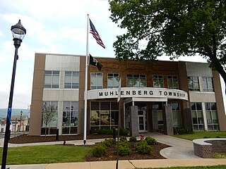
Muhlenberg Township is a township in Berks County, Pennsylvania, United States. The population was 21,915 at the 2020 census, making it the third-most populous township in Berks County after Spring Township and Exeter Township.

<span class="mw-page-title-main">Oley Township, Pennsylvania</span> Township in Pennsylvania, United States

Oley Township is a township in Berks County, Pennsylvania, United States. As of the 2010 census, the township had a population of 3,620. Oley Township was originally formed in 1740 as a part of Philadelphia County, before Berks County was formed in 1752. The entire township was listed as a historic district by the National Register of Historic Places in 1983. Oley is a Native American name purported to mean "a hollow". Daniel Boone was born in Oley Township November 2, 1734.

<span class="mw-page-title-main">Ontelaunee Township, Pennsylvania</span> Township in Pennsylvania, United States

Ontelaunee Township is a township in Berks County, Pennsylvania, United States. The population was 1,646 at the 2010 census.

<span class="mw-page-title-main">Tilden Township, Pennsylvania</span> Township in Pennsylvania, United States

Tilden Township is a township in Berks County, Pennsylvania, United States. The population was 3,597 at the 2010 census.

<span class="mw-page-title-main">Upper Bern Township, Pennsylvania</span> Township in Pennsylvania, United States

Upper Bern Township is a township in Berks County, Pennsylvania, United States. The population was 1,734 at the 2010 census.

<span class="mw-page-title-main">Upper Tulpehocken Township, Pennsylvania</span> Township in Pennsylvania, United States

Upper Tulpehocken Township is a township in Berks County, Pennsylvania, United States. The population was 1,575 at the 2010 census.

<span class="mw-page-title-main">Windsor Township, Berks County, Pennsylvania</span> Township in Pennsylvania, United States

Windsor Township is a township in Berks County, Pennsylvania, United States. The population was 2,279 at the 2010 census.

<span class="mw-page-title-main">North Coventry Township, Pennsylvania</span> Township in Pennsylvania, United States

North Coventry Township is a township in Chester County, Pennsylvania, United States. The population was 7,866 at the 2010 census.

<span class="mw-page-title-main">Schuylkill Township, Chester County, Pennsylvania</span> Township in Pennsylvania, United States

Schuylkill Township is a township in Chester County, Pennsylvania, United States. It contains the village of Valley Forge. The population was 8,516 at the 2010 census.

<span class="mw-page-title-main">Warwick Township, Chester County, Pennsylvania</span> Township in Pennsylvania, United States

Warwick Township is a township in Chester County, Pennsylvania, United States. The population was 2,507 at the 2010 census.

<span class="mw-page-title-main">Upper Hanover Township, Pennsylvania</span> Township in Pennsylvania, United States

Upper Hanover Township is a township in Montgomery County, Pennsylvania, United States. The population was 6,464 at the 2010 census.

<span class="mw-page-title-main">Douglassville, Pennsylvania</span> Census-designated place in Pennsylvania, United States

Douglassville is a census-designated place (CDP) in Amity Township in Berks County, Pennsylvania, United States. Douglassville is situated along U.S. Route 422 and Pennsylvania Route 724. Developments include the Amity Gardens subdivision, the West Ridge subdivision, the Briarwood subdivision, and the High Meadow subdivision. Douglassville also includes Cider Mill and the Woods Edge subdivision along Pennsylvania Route 562. As of the 2020 census, the population of the CDP was 518 residents.

References

  1. "2016 U.S. Gazetteer Files". United States Census Bureau. Retrieved August 13, 2017.
  2. 1 2 3 Bureau, US Census. "City and Town Population Totals: 2020-2021". Census.gov. US Census Bureau. Retrieved July 9, 2022.
  3. "Local school children to hear history of Berks and deeds of noted citizens". Reading Eagle. March 6, 1927. p. 5. Retrieved December 2, 2015.
  4. Andreas Rudman and his Family (by Dr. Peter Stebbins Craig . Swedish Colonial News, Volume 2, Number 1 . Winter 2000) "Pastor Andreas Rudman and his Family". Archived from the original on November 15, 2009. Retrieved September 7, 2009.
  5. "National Register Information System". National Register of Historic Places . National Park Service. March 13, 2009.
  6. "U.S. Census website". United States Census Bureau . Retrieved January 31, 2008.
  7. "Amity Township, Berks County, Pennsylvania". census.gov. Retrieved July 7, 2022.
  8. "Amity Township map" (PDF). PennDOT. Retrieved March 14, 2023.