Boyertown, Pennsylvania

Last updated
Boyertown
Boyerschteddel
Boyertown - Cannonhill.JPG
Boyertown viewed from atop Cannon Hill
Boyertown.png
Location of Boyertown in Berks County, Pennsylvania
USA Pennsylvania location map.svg
Red pog.svg
Boyertown
Location of Boyertown in Pennsylvania
Coordinates: 40°19′53″N75°38′10″W / 40.33139°N 75.63611°W / 40.33139; -75.63611
CountryUnited States
State Pennsylvania
County Berks
Area
[1]
  Total0.77 sq mi (2.00 km2)
  Land0.77 sq mi (2.00 km2)
  Water0.00 sq mi (0.00 km2)
Elevation
407 ft (124 m)
Population
 (2020) [2]
  Total4,264
  Density5,516.17/sq mi (2,128.96/km2)
Time zone UTC-5 (EST)
  Summer (DST) UTC-4 (EDT)
ZIP Code
19512
Area code(s) 610
Website boyertownborough.org

Boyertown (Pennsylvania Dutch: Boyerschteddel) is a borough in Berks County, Pennsylvania, United States. The population was 4,055 at the 2010 census. [3] Boyertown is known for the many painted fiberglass bears that can be found throughout the town and borough.

Contents

History

A post office called Boyertown has been in operation since 1828. [4] The community was named for its founders, brothers Henry and Daniel Boyer. [5]

In 1908, Boyertown was the site of the Rhoads Opera House fire. [6]

Geography

Boyertown is located along the southeastern border of Berks County. It is bordered on the north, west, and south by Colebrookdale Township, and to the southeast by Douglass Township in Montgomery County.

Boyertown is included in the Reading metropolitan statistical area, which is part the Philadelphia-Reading-Camden combined statistical area.

According to the U.S. Census Bureau, Boyertown has a total area of 0.77 square miles (2.0 km2), all land. [3] It has a hot-summer humid continental climate (Dfa) and average monthly temperatures range from 30.0 °F in January to 74.7 °F in July. The hardiness zone is 6b.

Demographics

Historical population
CensusPop.Note
1870 690
1880 1,09959.3%
1890 1,43630.7%
1900 1,70919.0%
1910 2,43342.4%
1920 3,18931.1%
1930 3,94323.6%
1940 3,9831.0%
1950 4,0742.3%
1960 4,067−0.2%
1970 4,4288.9%
1980 3,979−10.1%
1990 3,759−5.5%
2000 3,9404.8%
2010 4,0552.9%
2020 4,2645.2%
Sources: [7] [8] [9] [2]

As of the 2000 census, [8] there were 3,940 people, 1,805 households, and 1,025 families residing in the borough. The population density was 4,941.7 inhabitants per square mile (1,908.0/km2). There were 1,885 housing units at an average density of 2,364.2 per square mile (912.8/km2). The racial makeup of the borough was 98.83% White, 0.20% African American, 0.03% Native American, 0.36% Asian, 0.13% from other races, and 0.46% from two or more races. Hispanic or Latino of any race were 0.74% of the population.

There were 1,805 households, out of which 24.2% had children under the age of 18 living with them, 44.4% were married couples living together, 8.5% had a female householder, and 43.2% were non-families. 37.5% of all households were made up of individuals, and 19.3% had someone living alone who was 65 years of age or older. The average household size was 2.17 and the average family size was 2.87.

In the borough, the population was spread out, with 21.1% under the age of 18, 7.5% from 18 to 24, 29.2% from 25 to 44, 21.0% from 45 to 64, and 21.2% who were 65 years of age or older. The median age was 40 years. For every 100 females there were 92.5 males. For every 100 females age 18 and over, there were 87.7 males.

The median income for a household in the borough was $39,232, and the median income for a family was $52,943. Males had a median income of $33,783 versus $26,507 for females. The per capita income for the borough was $21,194. About 3.6% of families and 6.0% of the population were below the poverty line, including 5.6% of those under age 18 and 7.5% of those age 65 or over.

Transportation

PA 73 eastbound in Boyertown 2022-08-30 15 19 17 View east along Pennsylvania State Route 73 (Philadelphia Avenue) just east of Pennsylvania State Route 562 (Reading Avenue) in Boyertown, Berks County, Pennsylvania.jpg
PA 73 eastbound in Boyertown

As of 2020, there were 12.82 miles (20.63 km) of public roads in Boyertown, of which 1.91 miles (3.07 km) were maintained by the Pennsylvania Department of Transportation (PennDOT) and 10.91 miles (17.56 km) were maintained by the borough. [10]

Pennsylvania Route 73 (Philadelphia Avenue) is the main east–west road through the borough. It leads east-southeast to Schwenksville and eventually Northeast Philadelphia. To the northwest it leads to Blandon north of Reading. Pennsylvania Route 562 (Reading Avenue) leads west to Reading proper. Pennsylvania Route 100 bypasses the borough just outside its eastern border, leading north to Macungie near Allentown and south into Pottstown. A railroad line runs south from Boyertown to Pottstown. This line is used by the Colebrookdale Railroad tourist line and the Eastern Berks Gateway Railroad freight line.

Public education

The borough is served by the Boyertown Area School District.This includes one senior high school, two middle schools, six elementary schools, and a cyber school program. [11]

Media

The area is served by The Berks-Mont News , a weekly paper with a circulation of 5,500.

Landmarks

Notable people

Sister cities

Boyertown has one sister city, as designated by Sister Cities International:

Related Research Articles

<span class="mw-page-title-main">Amity Township, Berks County, Pennsylvania</span> Township in Pennsylvania, United States

Amity Township is a township in Berks County, Pennsylvania, United States. The population was 13,435 at the 2020 census. Amity Township, especially in the Douglassville area, is seeing growth in development.

<span class="mw-page-title-main">Bally, Pennsylvania</span> Borough in Pennsylvania, United States

Bally is a borough in Berks County, Pennsylvania, United States. The population was 1,090 at the 2010 census.

<span class="mw-page-title-main">Bechtelsville, Pennsylvania</span> Borough in Pennsylvania, United States

Bechtelsville is a borough in Berks County, Pennsylvania, United States. The population was 942 at the 2010 census.

<span class="mw-page-title-main">Colebrookdale Township, Pennsylvania</span> Township in Pennsylvania, United States

Colebrookdale Township is a township in Berks County, Pennsylvania, United States. The population was 5,127 at the 2020 census.

<span class="mw-page-title-main">Douglass Township, Berks County, Pennsylvania</span> Township in Pennsylvania, United States

Douglass Township is a township in Berks County, Pennsylvania, United States. The population was 3,664 at the 2020 census.

<span class="mw-page-title-main">Earl Township, Berks County, Pennsylvania</span> Township in Pennsylvania, United States

Earl Township is a township in Berks County, Pennsylvania, United States. The population was 3,102 at the 2020 census. Earl Township was named for early German settler Hans Graaf. His surname Graaf means "earl" in English.

<span class="mw-page-title-main">Exeter Township, Berks County, Pennsylvania</span> Township in Pennsylvania, United States

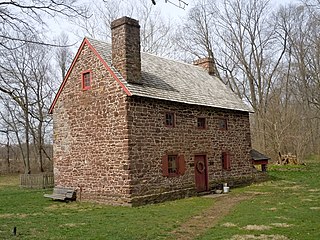
Exeter Township is a township in Berks County, Pennsylvania, United States. The population was 25,500 as of the 2020 census, making it the third-most populous municipality in Berks County after the city of Reading and Spring Township. Daniel Boone Homestead is within its borders. This formerly rural township is now made up of mostly sprawl-oriented developments along U.S. Route 422 and Route 562 Its school district also contains the adjacent borough of St. Lawrence.

<span class="mw-page-title-main">Fleetwood, Pennsylvania</span> Borough in Pennsylvania, United States

Fleetwood, also called Schlegelschteddel in Pennsylvania Dutch, is a borough in Berks County, Pennsylvania, United States. The population was 4,085 at the 2010 census. It was home to the Fleetwood Metal Body company, an automobile coachbuilder purchased by Fisher Body and integrated into General Motors in 1931. The name lived on in the Cadillac Fleetwood automobile.

<span class="mw-page-title-main">Leesport, Pennsylvania</span> Borough in Pennsylvania, United States

Leesport is a borough in Berks County, Pennsylvania, United States. The population was 1,918 at the 2010 census.

<span class="mw-page-title-main">Lenhartsville, Pennsylvania</span> Borough in Pennsylvania, United States

Lenhartsville is a borough in Berks County, Pennsylvania, United States. The population was 165 at the 2010 census.

<span class="mw-page-title-main">Mount Penn, Pennsylvania</span> Borough in Pennsylvania, United States

Mount Penn is a borough in Berks County, Pennsylvania, United States. The population was 3,106 at the 2010 census. The borough shares a name with a 1,120-foot-high (340 m) mountain that rises to the north and overlooks the city of Reading. The peak is sometimes recognized as the southern end of the Reading Prong group of mountains.

<span class="mw-page-title-main">New Morgan, Pennsylvania</span> Borough in Berks County, Pennsylvania, United States

New Morgan is a borough in Berks County, Pennsylvania, United States. The population was 71 at the 2010 census.

<span class="mw-page-title-main">Shoemakersville, Pennsylvania</span> Borough in Pennsylvania, United States

Shoemakersville is a borough in Berks County, Pennsylvania, United States. The population was 1,378 at the 2010 census, a decline from the figure of 2,124 tabulated in 2000.

<span class="mw-page-title-main">St. Lawrence, Pennsylvania</span> Borough in Pennsylvania, United States

St. Lawrence, is a borough in Berks County, Pennsylvania, United States. The population was 1,809 at the 2010 census. It sits just east of Mount Penn and Reading. It is served by the Exeter Township School District.

<span class="mw-page-title-main">Washington Township, Berks County, Pennsylvania</span> Township in Pennsylvania, United States

Washington Township is a township in eastern Berks County, Pennsylvania, United States. The population was 3,810 at the 2010 census.

<span class="mw-page-title-main">North Coventry Township, Pennsylvania</span> Township in Pennsylvania, United States

North Coventry Township is a township in Chester County, Pennsylvania, United States. The population was 7,866 at the 2010 census.

<span class="mw-page-title-main">Douglass Township, Montgomery County, Pennsylvania</span> Township in Pennsylvania, United States

Douglass Township is a township in Montgomery County, Pennsylvania, United States. The population was 10,195 at the 2010 census.

<span class="mw-page-title-main">Pottstown, Pennsylvania</span> Borough in Pennsylvania, United States

Pottstown is a borough in Montgomery County, Pennsylvania, United States. Pottstown was laid out in 1752–53 and named Pottsgrove in honor of its founder, John Potts. The old name was abandoned at the time of the incorporation as a borough in 1815. In 1888, the limits of the borough were considerably extended. Pottstown is the center of a productive farming and dairying region.

<span class="mw-page-title-main">Upper Pottsgrove Township, Pennsylvania</span> Township in Pennsylvania, United States

Upper Pottsgrove Township is a township in Montgomery County, Pennsylvania, United States. The population was 5,315 at the 2010 census.

<span class="mw-page-title-main">Boyertown Area School District</span> School district in southeastern Pennsylvania, U.S.

The Boyertown Area School District is a large public school district which covers portions of Berks and Montgomery Counties in southeastern Pennsylvania. When the Boyertown Area School District was formed in 1953 it was one of the largest in the state, encompassing 100 square miles (260 km2). In Berks County it covers the Boroughs of Bally, Bechtelsville and Boyertown and Colebrookdale Township, Douglass Township, Earl Township and Washington Township. In Montgomery County it covers Douglass Township, New Hanover Township and Upper Frederick Township.

References

  1. "ArcGIS REST Services Directory". United States Census Bureau. Retrieved October 12, 2022.
  2. 1 2 "Census Population API". United States Census Bureau. Retrieved Oct 12, 2022.
  3. 1 2 "Geographic Identifiers: 2010 Demographic Profile Data (G001): Boyertown borough, Pennsylvania". U.S. Census Bureau, American Factfinder. Archived from the original on February 12, 2020. Retrieved March 6, 2014.
  4. "Berks County". Jim Forte Postal History. Archived from the original on 13 January 2016. Retrieved 2 December 2015.
  5. "Rhoads family of Berks and its doctor poet". Reading Eagle. Nov 28, 1920. p. 22. Retrieved 2 December 2015.
  6. Schneider, Mary Jane (1991) Midwinter Mourning: The Boyertown Opera House Fire. MJS Publications
  7. "Census of Population and Housing". U.S. Census Bureau. Retrieved 11 December 2013.
  8. 1 2 "U.S. Census website". United States Census Bureau . Retrieved 2008-01-31.
  9. "Incorporated Places and Minor Civil Divisions Datasets: Subcounty Resident Population Estimates: April 1, 2010 to July 1, 2012". Population Estimates. U.S. Census Bureau. Archived from the original on 11 June 2013. Retrieved 11 December 2013.
  10. "Boyertown Borough map" (PDF). PennDOT. Retrieved March 13, 2023.
  11. "Boyertown Area School District / BASD Homepage". www.boyertownasd.org. Retrieved 2023-04-25.