Mount Joy is a borough in Lancaster County, Pennsylvania, United States. The population was 8,346 at the 2020 census, and an estimated 8,323 in 2021.

Paradise is an unincorporated community and census-designated place (CDP) in Lancaster County, Pennsylvania, United States, with a ZIP code of 17562. The population was 1,129 at the 2010 census.

Mount Joy Township is a township that is located in northwestern Lancaster County, Pennsylvania, United States. The population was 10,753 at the time of the 2020 census.
Mountville is a borough in Lancaster County, Pennsylvania, United States. The population was 3,022 at the 2020 census, an increase over the figure of 2,802 tabulated in 2010. The original Charles Chips potato chip factory was located here.
Mount Gretna Heights is an unincorporated community and census-designated place (CDP) in Lebanon County, Pennsylvania, United States, adjacent to the borough of Mount Gretna. The population was 323 at the 2010 census.
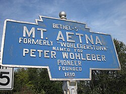
Forestville is a census-designated place (CDP) in Schuylkill County, Pennsylvania, United States. The population was 431 at the 2000 census.

Mount Wolf is a borough in York County, Pennsylvania, United States. The population was 1,367 at the 2020 census.
Hickory is a census-designated place located in Mount Pleasant Township, Washington County in the state of Pennsylvania. As of the 2010 census the population was 740 residents.

Montello is an unincorporated community in Spring Township, Berks County, Pennsylvania, United States. It is located one mile south of Sinking Spring, and is less than half a mile from the South Heidelberg Township line. The village is served by the Wilson School District. Its Zip Code is 19608.
Enhaut is an unincorporated community and census-designated place (CDP) located in Swatara Township, Dauphin County, Pennsylvania, United States. The community was formerly part of the census-designated place of Bressler-Enhaut-Oberlin, before splitting into three separate CDPs for the 2010 census. As of the 2010 census, the population in Enhaut was 1,007.

Lenkerville is an unincorporated community and census-designated place in Upper Paxton Township, Dauphin County, Pennsylvania, United States. It is less than one mile south of the borough of Millersburg along Pennsylvania Route 147, which lies on the east bank of the Susquehanna River. As of the 2010 census the population was 550.

Atlas is a census-designated place located in Mount Carmel Township, Northumberland County in the state of Pennsylvania. The community is located very close to the borough of Mount Carmel along Pennsylvania Route 61. As of the 2010 census the population was 809 residents.
Kapp Heights is a census-designated place located in Point Township, Northumberland County in the state of Pennsylvania. The community is located very close to the borough of Northumberland along Pennsylvania Route 147, near the confluence of the West Branch Susquehanna River and Susquehanna Rivers. As of the 2010 census the population was 863 residents.

Montandon is a census-designated place located in West Chillisquaque Township, Northumberland County in the state of Pennsylvania, United States. The community is located near the West Branch Susquehanna River at the intersections of Pennsylvania Routes 147 and 45, roughly halfway between the boroughs of Northumberland and Milton. As of the 2010 census the population was 903 residents.

Grier City is a census-designated place located in Rush Township, Schuylkill County in the state of Pennsylvania, United States. Grier City was part of the Grier City-Park Crest CDP for the 2000 census, before splitting into two separate CDPs for the 2010 census, the other being Park Crest. The community is located off Interstate 81. As of the 2010 census, the population was 241 residents. As of the 2020 census, the population was 296 residents.

Hegins is a census-designated place located in Hegins Township, Schuylkill County in the state of Pennsylvania, United States. The community is located near the community of Valley View at the intersection of Pennsylvania Routes 25 and 125 and is approximately 50 miles northeast of Harrisburg. As of the 2018 the population was 850.

Muir is a census-designated place located in Porter Township, Schuylkill County in the state of Pennsylvania, United States. Muir was part of the Reinerton-Orwin-Muir CDP at the 2000 census before splitting into three individual CDPs for the 2010 census. The other communities, along with Muir are Reinerton and Orwin. The community is located near the borough of Tower City along U.S. Route 209. As of the 2010 census, the population was 451 residents.
Orwin is a census-designated place located in Porter Township, Schuylkill County in the state of Pennsylvania, United States. Orwin was part of the Reinerton-Orwin-Muir CDP at the 2000 census before splitting into three individual CDPs for the 2010 census. The other communities, along with Orwin are Reinerton and Muir. The community is located near the community of Muir along U.S. Route 209. As of the 2010 census, the population was 314 residents.
Park Crest is a census-designated place located in Rush Township in Schuylkill County in the state of Pennsylvania, United States. Park Crest was part of the Grier City-Park Crest CDP for the 2000 census, before splitting into two separate CDPs for the 2010 census, the other being Grier City. The community is located off Interstate 81. As of the 2010 census, the population was 542 residents.

Dalmatia is a census-designated place located in Lower Mahanoy Township, Northumberland County in the state of Pennsylvania. The community is located along Pennsylvania Route 147 in southwestern Northumberland County, along the Susquehanna River. As of the 2010 census the population was 488 residents.