
Boyertown is a borough in Berks County, Pennsylvania, United States. The population was 4,055 at the 2010 census. Boyertown is known for the many painted fiberglass bears that can be found throughout the town and borough.

Douglass Township is a township in Berks County, Pennsylvania, United States. The population was 3,664 at the 2020 census.

Oley Township is a township in Berks County, Pennsylvania, United States. As of the 2010 census, the township had a population of 3,620. Oley Township was originally formed in 1740 as a part of Philadelphia County, before Berks County was formed in 1752. The entire township was listed as a historic district by the National Register of Historic Places in 1983. Oley is a Native American name purported to mean "a hollow". Daniel Boone was born in Oley Township November 2, 1734.
Washington Township is a township in eastern Berks County, Pennsylvania, United States. The population was 3,810 at the 2010 census.

Pottstown is a borough in Montgomery County, Pennsylvania, United States. Pottstown was laid out in 1752–53 and named Pottsgrove in honor of its founder, John Potts. The old name was abandoned at the time of the incorporation as a borough in 1815. In 1888, the limits of the borough were considerably extended. Pottstown is the center of a productive farming and dairying region.

Upper Pottsgrove Township is a township in Montgomery County, Pennsylvania, United States. The population was 5,315 at the 2010 census.

Pennsylvania Route 100 is a 59.4-mile (95.6 km) long state highway in the U.S. state of Pennsylvania that runs from U.S. Route 202 near West Chester north to PA 309 in Pleasant Corners. The route runs between the western suburbs of Philadelphia and the Lehigh Valley region of the state, serving Chester, Montgomery, Berks, and Lehigh counties. PA 100 intersects several important highways, including US 30 in Exton, the Pennsylvania Turnpike (Interstate 76, near Lionville, US 422 near Pottstown, US 222 in Trexlertown, and I-78/US 22 in Fogelsville. Several sections of PA 100 are multi-lane divided highway with some interchanges, including between US 202 and the Pennsylvania Turnpike in Chester County between south of Pottstown and New Berlinville, and between Trexlertown and Fogelsville.
Matthias Richards was a member of the United States House of Representatives from Pennsylvania.
Twin Valley School District (TVSD) is a school district headquartered in Caernarvon Township, Berks County, Pennsylvania, with an Elverson postal address. Within Berks County the district includes Caernarvon Township, New Morgan, and Robeson Township. Within Chester County the district includes Elverson, Honey Brook, Honey Brook Township, and West Nantmeal Township.

Pennsylvania Route 562 is a state highway in Berks County, Pennsylvania. The route runs 13.92 mi (22.40 km) from U.S. Route 422 Business in St. Lawrence east to PA 73 in Boyertown. PA 562 is a two-lane undivided road its entire length, passing through rural areas of eastern Berks County as it connects Boyertown to the Reading area. Along the way, PA 562 intersects PA 662 in the community of Yellow House. PA 562 was first designated by 1930 between Stonersville and PA 62 southwest of Boyertown, running via Amityville and Yellow House. In the 1930s, the route was extended west to US 422 in St. Lawrence and was realigned to its current alignment. PA 562 was extended east to PA 73 in 1964 after PA 100 was shifted to a new alignment to the east of Boyertown.
Pennsylvania State Senate District 24 includes parts of Berks County and Montgomery County. It is currently represented by Republican Tracy Pennycuick.

The Boyertown Area School District is a large public school district which covers portions of Berks and Montgomery Counties in southeastern Pennsylvania. When the Boyertown Area School District was formed in 1953 it was one of the largest in the state, encompassing 100 square miles (260 km2). In Berks County it covers the Boroughs of Bally, Bechtelsville and Boyertown and Colebrookdale Township, Douglass Township, Earl Township and Washington Township. In Montgomery County it covers Douglass Township, New Hanover Township and Upper Frederick Township.

The 130th Pennsylvania House of Representatives District is located in Southeastern Pennsylvania and has been represented since 2011 by David M. Maloney.
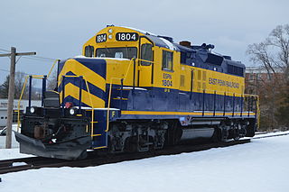
East Penn Railroad is a short-line railroad that operates a number of mostly-unconnected lines in Pennsylvania and Delaware. Except for two industrial park switching operations, all are former Pennsylvania Railroad or Reading Company lines, abandoned or sold by Conrail or its predecessors.
Landis Store is a village in District Township, Berks County, Pennsylvania, United States. It is drained by the West Branch Perkiomen Creek into the Perkiomen Creek in the Green Lane Reservoir. It is split between the Alburtis zip code of 18011, the Barto zip code of 19504, and the Boyertown zip code of 19512.
The Eastern Berks Gateway Railroad is a short-line railroad in Pennsylvania that runs from Boyertown south to Pottstown over the Colebrookdale branch, where it interchanges with the Norfolk Southern Railway. The railroad was operated by U.S. Rail Partners until 2013, when the Colebrookdale Railroad Preservation Trust took over.

The Colebrookdale Railroad, also known as the Secret Valley Line or colloquially as The Colebrookdale, is a tourist railroad located in the U.S. state of Pennsylvania. The railroad operates between Boyertown in Berks County and Pottstown in Montgomery County.
Earlville is an unincorporated community on the border of Amity and Earl townships in Berks County, Pennsylvania, United States. Earlville is located along Pennsylvania Route 562 at the crossing of Manatawny Creek, west of Boyertown.
Pine Forge is an unincorporated community in Douglass Township in Berks County, Pennsylvania, United States. Pine Forge is located along Manatawny Drive to the north of the Manatawny Creek and southwest of Boyertown.

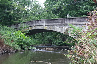
The Colebrookdale branch, also known as the Colebrookdale spur, Colebrookdale industrial track or Colebrookdale line, is a railway line in Pennsylvania. It runs 8.6 miles (13.8 km) from a junction with the Harrisburg Line in Pottstown to Boyertown. At its fullest extent, the line continued another 4 miles (6.4 km) to Barto. The line was built between 1868 and 1869 by the Colebrookdale Railroad and part of the Reading Company system until 1976. Berks County has owned the line since 2009. The Eastern Berks Gateway Railroad operates freight service; heritage passenger services are run under the Colebrookdale Railroad name.

