
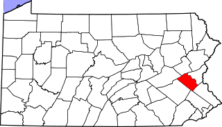
Greenwich Township is a township in Berks County, Pennsylvania, United States. The population was 3,438 at the 2020 census.

Maidencreek Township is a township in Berks County, Pennsylvania, United States. The population was 9,126 at the 2010 census.

Richmond Township is a township in Berks County, Pennsylvania, United States. The population was 3,397 at the 2010 census.
Hereford is a census-designated place in Hereford Township, Berks County, Pennsylvania, United States. The community lies at the intersection of Pennsylvania Routes 29 and 100, which connect it to East Greenville and to Pottstown, respectively to the south. They continue north on Chestnut Street to Shimerville in Lehigh County, where 29 continues toward Allentown. The Perkiomen Creek flows south through Hereford to the Schuylkill River.

Pennsylvania Route 143 (PA 143) is a 20-mile-long (32 km) state highway in Pennsylvania. It runs from PA 662 in Richmond Township, Berks County northeast to PA 309 near New Tripoli in Lehigh County. The route passes through rural areas, intersecting Interstate 78 (I-78)/U.S. Route 22 (US 22) in Lenhartsville, PA 737 near Kempton, and PA 863 in Lynnport. What is now PA 143 north of Lenhartsville was originally designated Legislative Route 285 in 1911. PA 143 was designated to in 1928 to run from PA 43 in Lenhartsville to PA 29 near New Tripoli. The route was extended slightly east through New Tripoli by 1940 following a realignment of PA 29. PA 143 was extended south to PA 662 in 1962.

Pennsylvania Route 737 (PA 737) is a state highway in Berks County, Pennsylvania. The route runs from U.S. Route 222 (US 222) in the borough of Kutztown north to PA 143 in Albany Township. PA 737 heads north from an interchange with US 222 north of Kutztown on Krumsville Road. It continues north through a small part of Maxatawny Township into Greenwich Township. The road features an interchange with Interstate 78 (I-78)/US 22 in the village of Krumsville. PA 737 then heads northwest into Albany Township, where it ends at PA 143 near the village of Kempton.
New Smithville is an unincorporated community in Weisenberg Township in Lehigh County, Pennsylvania. It is located west of the city of Allentown and near the border with Berks County. It is part of the Lehigh Valley, which has a population of 861,899 and is the 68th most populous metropolitan area in the U.S. as of the 2020 census.
Geigertown is an unincorporated community in Berks County, Pennsylvania.
Sacony Creek is a 17.4-mile-long (28.0 km) tributary of Maiden Creek in Berks County, Pennsylvania in the United States. It flows through the borough of Kutztown, and is the main water source there. The Pennsylvania Fish and Boat Commission stock trout into the creek annually.
Walnuttown is a census-designated place in Berks County, Pennsylvania, United States. It is mainly in Richmond Township but also in Maidencreek Township. It is a short distance west of Fleetwood and south of U.S. Route 222. Willow Creek flows west through it into Maiden Creek just east of the latter's mouth into the Schuylkill River. Walnuttown is served by the Fleetwood post office, which uses the ZIP code of 19522. As of the 2010 census the population of Walnuttown was 484. It is served by the Fleetwood Area School District.
Greenawald is an unincorporated community in Albany Township in Berks County, Pennsylvania, United States. Greenawald is located along Pennsylvania Route 143 and Maiden Creek in the southern part of the township.
Moselem is an unincorporated community in Richmond Township in Berks County, Pennsylvania, United States. Moselem is located along Pennsylvania Route 662, east of Maiden Creek.
Earlville is an unincorporated community on the border of Amity and Earl townships in Berks County, Pennsylvania, United States. Earlville is located along Pennsylvania Route 562 at the crossing of Manatawny Creek west of Boyertown.
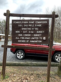
The Pennsylvania State Game Lands Number 43 are Pennsylvania State Game Lands in Berks and Chester Counties in Pennsylvania in the United States providing hunting, bird watching, and other activities. It is the only State Game Lands located in Chester County.
The Pennsylvania State Game Lands Number 52 are Pennsylvania State Game Lands in Berks and Lancaster Counties in Pennsylvania in the United States providing hunting, bird watching, and other activities.
The Pennsylvania State Game Lands Number 80 are Pennsylvania State Game Lands in Berks, Lebanon and Schuylkill Counties in Pennsylvania, providing hunting, bird watching, and other activities.
The Pennsylvania State Game Lands Number 182 are Pennsylvania State Game Lands in Berks County in Pennsylvania in the United States providing hunting, bird watching, and other activities.
The Pennsylvania State Game Lands Number 274 are Pennsylvania State Game Lands in Berks and Lancaster Counties in Pennsylvania in the United States providing hunting, bird watching, and other activities.
The Pennsylvania State Game Lands Number 280 are Pennsylvania State Game Lands in Berks County in Pennsylvania in the United States providing hunting, bird watching, and other activities.
The Pennsylvania State Game Lands Number 315 are Pennsylvania State Game Lands in Berks County in Pennsylvania in the United States providing hunting, bird watching, and other activities.


