
Skytop is an unincorporated community in Barrett Township, Monroe County, Pennsylvania, United States. Located north of Mountainhome, it is accessible by local roads off Route 390. Its elevation is 1,562 feet (476 m), and it is located at 41°13′40″N 75°14′18″W. Although Skytop is unincorporated, it has a post office, with the ZIP code of 18357; the ZCTA for ZIP Code 18357 had a population of 87 at the 2000 census.

Kimberton is an unincorporated community in East Pikeland Township in Chester County, Pennsylvania, United States. The zip code is 19442. Originally settled in the late 18th century, it was not named until 1817. Like many surrounding villages, Kimberton developed around a tavern; in this case, the tavern was called Chrisman's. In 1796, the Chrisman's Mill began operating, drawing activity to the tiny village. It operated until 1938 and is currently the town's post office. Its current population is 7,901.

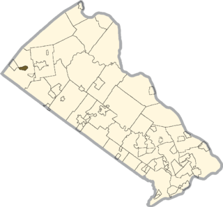
Jonas, Pennsylvania is an unincorporated community in Monroe County, Pennsylvania, United States. The community is located on Route 534 in Polk Township. It is split between the Effort ZIP code of 18330 and the Kunkletown ZIP code of 18058.

Malaga is an unincorporated community in northern Malaga Township, Monroe County, Ohio, United States. Although it is unincorporated, it has a post office, with the ZIP code of 43757. It lies at the intersection of State Routes 145 and 800.
Zieglerville is an unincorporated community in Lower Frederick Township, Montgomery County, Pennsylvania, United States. Its ZIP Code is 19492 and it is located on the west side of the Perkiomen Creek where Route 29 and Route 73 split at a roundabout just north of Schwenksville.
Gilbert is an unincorporated community in Monroe County, Pennsylvania, United States. The ZCTA for its ZIP Code, 18331, had a population of 459 at the 2000 census. It is located on U.S. Route 209 in Chestnuthill Township and Polk Township. The Pohopoco Creek runs it southward through Gilbert then westward through Beltzville Lake to the Lehigh River. Gilbert is served by the 681 exchange in Area Code 610. Students in the village area attend the Pleasant Valley School District.
Hollo is an unincorporated community in Northampton County, Pennsylvania, United States. Located at 40°43′22″N 75°17′44″W, Hollo lies a short distance southeast of the borough of Nazareth, at an altitude of 436 feet (133 m). The intersection of Nazareth Road and Hollo Road lies in northeastern Lower Nazareth Township, southeast of Nazareth and northwest of the city of Easton. Hollo is split between the Easton ZIP code of 18045 and the Nazareth ZIP code of 18064.
Karns is an unincorporated community in Harrison Township, Allegheny County, Pennsylvania, USA; it is located in Western Pennsylvania within the Pittsburgh Metropolitan Statistical Area, approximately 24 miles (39 km) northeast of Pittsburgh. Karns is situated along the Allegheny River at Pool 4 across from Jacks Island just above Lock and Dam 4 between Natrona, Natrona Heights, and Sligo. The elevation of Karns is 817 feet above sea level.
Limeport is a small unincorporated community on the Saucon Creek in Lower Milford Township and Upper Saucon Township in Lehigh County, Pennsylvania, United States. It is served by Limeport Post Office, so village residents use Limeport as their mailing address and the ZIP Code is 18060. Limeport is within the Southern Lehigh School District.

Boyers Junction is an unincorporated community in Berks County, Pennsylvania. The village is located in southwestern Rockland Township, near the Ruscombmanor Township line. It is also southeast of Fleetwood and south of Lyons. It is drained by the Bieber Creek southward into the Manatawny Creek, a tributary of the Schuylkill River. The Brandywine Heights Area School District serves Boyers Junction, which uses the Fleetwood zip code of 19522.
Powder Valley is a village in southern Upper Milford Township, Lehigh County, Pennsylvania, United States. It is located on the Indian Creek, which comes from the NW, turns south, and flows through a gorge starting there into the Hosensack Creek The village uses the Zionsville zip code of 18092. Stahl's Pottery was located in Powder Valley off Corning Road.

Chapel is a village located on Pennsylvania Route 29 and the Perkiomen Creek in Hereford Township, Berks County and Upper Hanover Township, Montgomery County in the U.S. state of Pennsylvania. It uses the 18070 zip code of Palm, which is located just to the southeast. It is served by the Upper Perkiomen School District and uses the area code of 215.
Milford Square is a census-designated place in Milford Township, Bucks County, Pennsylvania. It is located along PA Route 663 near the borough of Trumbauersville. As of the 2010 census, the population was 897 residents. While the village has a PO Box post office with the zip code of 18935, the surrounding area uses the Quakertown zip code of 18951. It is located on the Unami Creek which drains into the Perkiomen Creek. It was formerly known as Heistville after the Heist family who operated Achey's Mill and lived in, and greatly renovated, the miller’s home.
Dryville is a census-designated place in Rockland Township, Berks County, Pennsylvania, United States. It is located one mile south of Lyons, and is located in the South Mountains and is drained by the Bieber Creek into the Manatawny Creek, a tributary of the Schuylkill River. It is split between the Fleetwood zip code of 19522 and the Mertztown zip code of 19539. The village grew around the Henry Mertz Lutheran Church, which opened in 1747. As of the 2010 census, the population was 398 residents.
Shelly is an unincorporated community in northwestern Richland Township, Bucks County, Pennsylvania located on the Tohickon Creek and PA Route 309. It uses the Quakertown zip code of 18951.
Elevation is 169 meters (554 ft.).
Flicksville is a village located in Northampton County, Pennsylvania, 75 miles (121 km) west of New York City, in the Lehigh Valley region of Pennsylvania, United States. It is part of Pennsylvania's Slate Belt and belongs to Washington Township. Flicksville previously had a post office with a ZIP code of 18050; however, this ZIP code was retired in 2016 and the community is now served by the Bangor ZIP code of 18013.

Kunkletown is an unincorporated community in Eldred Township, Monroe County, Pennsylvania, United States. It is located at an elevation of 531 feet. It is at ZIP Code 18058.
Ono is an unincorporated community in East Hanover Township, Lebanon County, Pennsylvania, United States, on U.S. Route 22 and about two miles SW of the junction of Interstate 78 and Interstate 81. The Swatara Creek to the south drains it into the Susquehanna River. While Ono has its own post office with the zip code of 17077, some residents are served by the Annville or Jonestown post office, with the zip code of 17003 or 17038, respectively.
Center Point, Pennsylvania is an unincorporated community in Worcester Township, Montgomery County at the junction of Routes 73 and 363. It is drained by the Zacharias Creek westward into the Skippack Creek, a tributary of the Perkiomen Creek. It is served by the Methacton School District and by the Collegeville, Lansdale, and Norristown post offices with the zip codes of 19426, 19446, and 19403, respectively.
McKnight is an unincorporated community in Allegheny County, Pennsylvania, United States. The area known as McKnight is located in the municipality of Ross Township, in suburban Pittsburgh, and in the North Hills School District.


