Marion Township, Berks County, Pennsylvania

Last updated
Marion Township
S Bridge Womelsdorf, Pennsylvania.jpg
S Bridgein Marion Township
Berks County Pennsylvania Incorporated areas Marion Township Highlighted.svg
USA Pennsylvania location map.svg
Red pog.svg
Marion Township
Location of Marion Township in Pennsylvania
Usa edcp location map.svg
Red pog.svg
Marion Township
Marion Township (the United States)
Coordinates: 40°23′00″N76°15′29″W / 40.38333°N 76.25806°W / 40.38333; -76.25806
CountryUnited States
StatePennsylvania
County Berks
Area
[1]
  Total15.13 sq mi (39.19 km2)
  Land15.09 sq mi (39.07 km2)
  Water0.05 sq mi (0.12 km2)
Elevation
404 ft (123 m)
Population
 (2010)
  Total1,688
  Estimate 
(2016) [2]
1,839
  Density121.91/sq mi (47.07/km2)
Time zone UTC-5 (EST)
  Summer (DST) UTC-4 (EDT)
Area codes 610, 717
FIPS code 42-011-47440

Marion Township is a township in Berks County, Pennsylvania, United States. The population was 1,688 at the 2010 census.

Contents

History

The S Bridge (Womelsdorf, Pennsylvania), Peter Spicker House, Stouchsburg Historic District, and Tulpehocken Creek Historic District are listed on the National Register of Historic Places. [3]

Geography

According to the U.S. Census Bureau, the township has a total area of 15.3 square miles (39.7 km2), of which 15.3 square miles (39.7 km2) is land and 0.07% is water.

Adjacent townships

The borough of Womelsdorf is adjacent to Marion Township on the south side. The unincorporated community of Stouchsburg is located within the township, just off U.S. Route 422.

Demographics

Historical population
CensusPop.Note
1980 1,341
1990 1,4155.5%
2000 1,57311.2%
2010 1,6887.3%
2016 (est.)1,839 [2] 8.9%
Source: US Census Bureau

As of the 2000 census, [4] there were 1,573 people, 524 households and 418 families living in the township. The population density was 102.6 inhabitants per square mile (39.6/km2). There were 551 housing units at an average density of 36.0 per square mile (13.9/km2). The racial makeup of the township was 97.20% White, 1.02% African American, 0.38% Native American, 0.13% Asian, 0.45% from other races, and 0.83% from two or more races. Hispanic or Latino of any race were 1.40% of the population.

There were 524 households, of which 35.5% had children under the age of 18 living with them, 67.4% were married couples living together, 8.0% had a female householder with no husband present, and 20.2% were non-families. 14.9% of all households were made up of individuals, and 5.9% had someone living alone who was 65 years of age or older. The average household size was 2.98 and the average family size was 3.36.

In the township, the population was spread out, with 28.6% under the age of 18, 8.4% from 18 to 24, 27.3% from 25 to 44, 25.2% from 45 to 64, and 10.6% who were 65 years of age or older. The median age was 36 years. For every 100 females there were 113.1 males. For every 100 females age 18 and over, there were 106.1 males.

The median income for a household in the township was $47,396, and the median income for a family was $52,167. Males had a median income of $35,517 compared with $22,179 for females. The per capita income for the township was $19,373. About 2.2% of families and 3.3% of the population were below the poverty line, including 3.3% of those under age 18 and 3.6% of those age 65 or over.

Transportation

US 422 westbound in Marion Township 2022-08-24 13 03 21 View west along U.S. Route 422 (Conrad Weiser Parkway) just west of Sheridan Road in Marion Township, Berks County, Pennsylvania.jpg
US 422 westbound in Marion Township

As of 2007, there were 41.88 miles (67.40 km) of public roads in Marion Township, of which 8.30 miles (13.36 km) were maintained by the Pennsylvania Department of Transportation (PennDOT) and 33.58 miles (54.04 km) were maintained by the township. [5]

U.S. Route 422, Pennsylvania Route 419 and Pennsylvania Route 501 are the numbered highways serving Marion Township. US 422 follows Conrad Weiser Parkway along a east-west alignment across the southern portion of the township. PA 419 follows Rehrersburg Road along a north-south alignment across the eastern part of the township. Finally, PA 501 clips the far northwestern corner of the township.

Related Research Articles

<span class="mw-page-title-main">Amity Township, Berks County, Pennsylvania</span> Township in Pennsylvania, United States

Amity Township is a township in Berks County, Pennsylvania, United States. The population was 13,435 at the 2020 census. Amity Township, especially in the Douglassville area, is seeing growth in development.

<span class="mw-page-title-main">Bethel Township, Berks County, Pennsylvania</span> Township in Pennsylvania, United States

Bethel Township is a township in Berks County, Pennsylvania, United States. The population was 4,072 at the 2020 census.

<span class="mw-page-title-main">Cumru Township, Pennsylvania</span> Township in Pennsylvania, United States

Cumru Township is a township in Berks County, Pennsylvania, United States. The population was 15,638 at the 2020 census. Nolde Forest Environmental Education Center, a Pennsylvania state park, is in Cumru Township.

<span class="mw-page-title-main">Douglass Township, Berks County, Pennsylvania</span> Township in Pennsylvania, United States

Douglass Township is a township in Berks County, Pennsylvania, United States. The population was 3,664 at the 2020 census.

<span class="mw-page-title-main">Earl Township, Berks County, Pennsylvania</span> Township in Pennsylvania, United States

Earl Township is a township in Berks County, Pennsylvania, United States. The population was 3,102 at the 2020 census. Earl Township was named for early German settler Hans Graaf. His surname Graaf means "earl" in English.

<span class="mw-page-title-main">Heidelberg Township, Berks County, Pennsylvania</span> Township in Pennsylvania, United States

Heidelberg Township is a township in Berks County, Pennsylvania, United States. The population was 1,726 at the 2020 census.

<span class="mw-page-title-main">Jefferson Township, Berks County, Pennsylvania</span> Township in Pennsylvania, United States

Jefferson Township is a township in Berks County, Pennsylvania, United States. The population was 2,376 at the 2020 census.

<span class="mw-page-title-main">Lower Heidelberg Township, Pennsylvania</span> Township in Pennsylvania, United States

Lower Heidelberg Township is a township in Berks County, Pennsylvania, United States. The population was 5,513 at the 2010 census.

<span class="mw-page-title-main">North Heidelberg Township, Pennsylvania</span> Township in Pennsylvania, United States

North Heidelberg Township is a township in Berks County, Pennsylvania, United States. The population was 1,214 at the 2010 census.

<span class="mw-page-title-main">Oley Township, Pennsylvania</span> Township in Pennsylvania, United States

Oley Township is a township in Berks County, Pennsylvania, United States. As of the 2010 census, the township had a population of 3,620. Oley Township was originally formed in 1740 as a part of Philadelphia County, before Berks County was formed in 1752. The entire township was listed as a historic district by the National Register of Historic Places in 1983. Oley is a Native American name purported to mean "a hollow". Daniel Boone was born in Oley Township November 2, 1734.

<span class="mw-page-title-main">Penn Township, Berks County, Pennsylvania</span> Township in Pennsylvania, United States

Penn Township is a township in Berks County, Pennsylvania, United States. The population was 1,949 at the 2010 census.

<span class="mw-page-title-main">Perry Township, Berks County, Pennsylvania</span> Township in Pennsylvania, United States

Perry Township is a township in Berks County, Pennsylvania, United States. The population was 2,417 at the 2010 census.

<span class="mw-page-title-main">Richmond Township, Berks County, Pennsylvania</span> Township in Pennsylvania, United States

Richmond Township is a township in Berks County, Pennsylvania, United States. The population was 3,397 at the 2010 census.

<span class="mw-page-title-main">South Heidelberg Township, Pennsylvania</span> Township in Pennsylvania, United States

South Heidelberg Township is a township in Berks County, Pennsylvania, United States. The population was 7,271 at the 2010 census.

<span class="mw-page-title-main">Spring Township, Berks County, Pennsylvania</span> Township in Pennsylvania, United States

Spring Township is a township in Berks County, Pennsylvania, United States. The population was 27,119 at the 2010 census, making it the second most populous municipality in Berks County after Reading.

<span class="mw-page-title-main">Tulpehocken Township, Pennsylvania</span> Township in Pennsylvania, United States

Tulpehocken Township is a township in Berks County, Pennsylvania, United States. The population was 3,274 at the 2010 census.

<span class="mw-page-title-main">Upper Bern Township, Pennsylvania</span> Township in Pennsylvania, United States

Upper Bern Township is a township in Berks County, Pennsylvania, United States. The population was 1,734 at the 2010 census.

<span class="mw-page-title-main">Upper Tulpehocken Township, Pennsylvania</span> Township in Pennsylvania, United States

Upper Tulpehocken Township is a township in Berks County, Pennsylvania, United States. The population was 1,575 at the 2010 census.

<span class="mw-page-title-main">Womelsdorf, Pennsylvania</span> Borough in Pennsylvania, United States

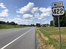
Womelsdorf is a borough in Berks County, Pennsylvania, United States. The population was 2,810 at the 2010 census. The main thoroughfares through Womelsdorf are High Street, which runs east–west, and Pennsylvania Route 419, which runs north–south. U.S. Route 422 runs along the northern edge of town.

<span class="mw-page-title-main">Newmanstown, Pennsylvania</span> Census-designated place in Pennsylvania, United States

Newmanstown is an unincorporated community and census-designated place (CDP) in Millcreek Township, Lebanon County, Pennsylvania. The population was 2,478 at the 2010 census, an increase over the figure of 1,536 tabulated in 2000.

References

  1. "2016 U.S. Gazetteer Files". United States Census Bureau. Retrieved Aug 13, 2017.
  2. 1 2 "Population and Housing Unit Estimates" . Retrieved June 9, 2017.
  3. "National Register Information System". National Register of Historic Places . National Park Service. July 9, 2010.
  4. "U.S. Census website". United States Census Bureau . Retrieved 2008-01-31.
  5. "Marion Township map" (PDF). PennDOT. Retrieved March 14, 2023.