Berks County is a county in the Commonwealth of Pennsylvania. As of the 2020 census, the county's population was 428,849. The county seat is Reading, the fourth-most populous city in the state.
Belle Rose is a census-designated place (CDP) in Assumption Parish, Louisiana, United States. The population was 1,902 at the 2010 census. It is part of the Pierre Part micropolitan statistical area.
Hopeland is a small unincorporated hamlet and census-designated place (CDP) that is located in Lancaster County in the south of the U.S. state of Pennsylvania in the United States. The hamlet's ZIP code is 17533.
Ezel is an unincorporated community and census-designated place (CDP) in Morgan County, Kentucky, United States. As of the 2020 census, it had a population of 209. It has a small post office, with the ZIP code 41425.

Nanafalia is an unincorporated community and census-designated place (CDP) in Marengo County, Alabama, United States. As of the 2020 census, its population was 75, down from 94 at the 2010 census. The community is located on a ridge above the Tombigbee River, and the name is derived from the Choctaw words for long hill. Nanafalia has a post office with a zip code of 36764.

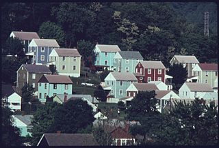
Bethel is a census-designated place in Bethel Township, Berks County, Pennsylvania, United States. It is located at the junction of Interstate 78/U.S. Route 22 and Pennsylvania Route 501. It is in the Susquehanna watershed and drained southward into the Little Swatara Creek. Its area code is 717. As of the 2010 census, the population was 499. Bethel was the original location that Cabela's was going to build their new location before they decided to build it in Hamburg. It is the home to the international headquarters of the Assemblies of Yahweh, to several small town business shops, and to a large distribution center for Dollar General and PetSmart, which can be seen while driving down Interstate 78. The village was formerly known as "Millersburg."

Jalappa is a village in Tilden Township, Berks County, Pennsylvania, United States. It is located on Old Route 22, less than one mile south of Interstate 78. Access to 78 is from Hamburg and Shartlesville. The Mill Creek flows eastward through the village to the Schuylkill River. The village uses the Hamburg ZIP code of 19526.
Bowers is a census-designated place in Maxatawny Township, Berks County, Pennsylvania.
Boody is an unincorporated community and census-designated place (CDP) in Macon County, Illinois, United States. As of the 2020 census, Boody had a population of 232, down from 276 in 2010. Boody has a post office with ZIP code 62514.
Boomer is a census-designated place (CDP) in Fayette County, West Virginia, United States. Boomer is located on the north bank of the Kanawha River, 2 miles (3.2 km) southeast of Smithers. Boomer has a post office with ZIP code 25031. As of the 2010 census, its population was 615.
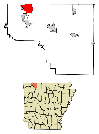
Holiday Island is a 4,500-acre planned retirement and vacation community in Carroll County, Arkansas, United States. Formerly an unincorporated community and census-designated place (CDP), they voted to incorporate in November 2020. As of the 2020 census, the population was 2,533. Holiday Island is located in the Ozark Mountains on Table Rock Lake near Eureka Springs, Arkansas and only an hour from Branson, Missouri, Fayetteville, Arkansas, and Bentonville, Arkansas. Community growth has been fueled by the expansion of the corporate giants headquartered in Northwest Arkansas, the entertainment attractions in Eureka Springs and Branson, the visitor traffic from the Crystal Bridges Museum of American Art, Pea Ridge National Military Park, and Roaring River State Park, and the influence of the state's largest University, the University of Arkansas.
Wesley is an unincorporated community and census-designated place (CDP) in western Madison County, Arkansas, United States. Wesley is located at the junction of Arkansas highways 74 and 295, 13 miles (21 km) by road west-southwest of Huntsville. Wesley has a post office with ZIP code 72773. It was first listed as a CDP in the 2020 census with a population of 161.
Oakland is an unincorporated community and census-designated place (CDP) in northeastern Marion County, Arkansas, United States. Oakland, located on Arkansas Highway 202, is 20 miles (32 km) by road northwest of Mountain Home. Oakland has a post office with ZIP code 72661. The Oakland Campground on Bull Shoals Lake lies about three miles to the west at the end of Route 202. It was first listed as a CDP in the 2020 census, with a population of 72.

Scenic is an unincorporated community and census-designated place (CDP) in Mohave County in extreme northwestern Arizona, United States. As of the 2020 census, its population was 1,321, down from 1,643 in 2010.

Oley, also called Friedensburg, is a census-designated place (CDP) that is located on Routes 73 and 662 in northern Oley Township, Berks County, United States.
Maxatawny is an unincorporated community located on U.S. Route 222 in Maxatawny Township, Berks County, Pennsylvania, United States, five miles east of Kutztown. It is in the Lehigh watershed and Schaefer Run flows through it to the Little Lehigh Creek. Maxatawny has a post office, with the ZIP code of 19538. Traffic speed on US 222 is reduced to 35 miles-per-hour passing through the village, which borders Lehigh County.
Dewy Rose is an unincorporated community and census-designated place (CDP) in Elbert County, Georgia, United States. Its population was 161 as of the 2020 census. Dewy Rose has a post office with ZIP code 30634. Georgia State Route 17 passes through the community.
Norristown is an unincorporated community and census-designated place (CDP) in Emanuel County, Georgia, United States. Its population was 54 as of the 2020 census.

Walnut Creek is an unincorporated community and census-designated place (CDP) in Mohave County, in the U.S. state of Arizona. The population was 571 at the 2020 census.
Eagle Point is a census-designated place in Shelby County, Alabama, United States. It was first listed as a CDP prior to the 2020 census and is part of the Birmingham Metropolitan Area. The area was struck by a long-tracked low-end EF3 tornado on March 25, 2021, damaging or destroying several homes and downing trees. Five people were injured by the tornado.