
Athol is a city in Kootenai County, Idaho, United States. The population was 709 at the 2020 census, up from 692 in 2010 census. It is part of the Coeur d'Alene Metropolitan Statistical Area, which includes the entire county.

Amityville is a village in the Town of Babylon in Suffolk County, on the South Shore of Long Island, in New York. The population was 9,523 at the 2010 census.
Hereford is a census-designated place in Hereford Township, Berks County, Pennsylvania, United States. The community lies at the intersection of Pennsylvania Routes 29 and 100, which connect it to East Greenville and to Pottstown, respectively to the south. These routes continue north on Chestnut Street to Shimerville in Lehigh County, where 29 continues toward Allentown. The Perkiomen Creek flows southward through Hereford to the Schuylkill River.

Pennsylvania Route 662 is a 26.17-mile-long (42.12 km) state highway located in Berks County in eastern Pennsylvania. Its southern terminus is at U.S. Route 422 in Douglassville and its northern terminus is at PA 61 in Shoemakersville. The route is a two-lane undivided road its entire length and passes through rural areas. PA 662 heads north from Douglassville, intersecting PA 562 in Yellow House before becoming concurrent with PA 73 northwest through Oley. From here, PA 662 continues north and meets PA 12 in Pricetown before passing through the borough of Fleetwood and coming to a junction with US 222 in Moselem Springs. After this, the route continues west and intersects PA 143 before reaching its terminus at PA 61.
Blandon is a census-designated place in Maidencreek Township, Berks County, Pennsylvania, United States. It is located at the junction of Pennsylvania Route 73 and Park Road. As of the 2010 census, the population was 7,152 residents.
Manatawny is an unincorporated community in Berks County, Pennsylvania, United States. It is located at the junction on PA Route 73 and Hoch Road in Oley Township, a short distance from Pleasantville.
Bowers is a census-designated place in Maxatawny Township, Berks County, Pennsylvania, United States. It is located near the borough of Lyons and is on Sacony Creek, a tributary of the Maiden Creek. As of the 2010 census, the population was 326 residents. Although Bowers has its own post office with the ZIP code of 19511, some residents are served by the Mertztown post office with the ZIP code of 19539.
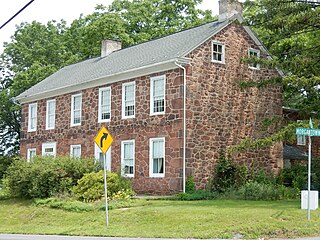
Weavertown is an unincorporated community in Amity Township, Berks County, Pennsylvania, United States. It is located approximately 3.6 miles north of Amity Gardens on Pennsylvania Route 662 and is served by the Daniel Boone Area School District.
Plowville is an unincorporated area of Robeson Township, Berks County, Pennsylvania, United States. it is located on Pennsylvania Route 10, just east of Interstate 176. Its zip code is 19540 and the community is served by the Twin Valley School District. The most recognizable landmark is Plow Church.
Berne is an unincorporated community in northern Berks County, Pennsylvania, United States. The community is approximately three miles outside Hamburg and is served by the Hamburg Area School District. Berne sits near the Schuylkill River, south of Blue Mountain, in southeastern Tilden Township.

Joanna is an unincorporated community in southern Berks County, Pennsylvania, United States. Joanna sits in southern Robeson Township, near the borough of New Morgan, and is also near Caernarvon Township and near the Pennsylvania Turnpike. The Twin Valley School District serves Joanna; the high school is located close to the village.

Oley, also called Friedensburg, is a census-designated place (CDP) that is located on Routes 73 and 662 in northern Oley Township, Berks County, United States.

Yellow House is a village in eastern Berks County, Pennsylvania, United States, situated at the junction of Routes 562 and 662. It is located in Amity Township and Oley Township. It is drained by the Manatawny Creek into the Schuylkill River. It is split between the Douglassville and Oley post offices, which use the ZIP codes of 19518 and 19547, respectively.
Maxatawny is an unincorporated community located on U.S. Route 222 in Maxatawny Township, Berks County, Pennsylvania, United States, five miles east of Kutztown. It is in the Lehigh watershed and Schaefer Run flows through it to the Little Lehigh Creek. Maxatawny has a post office, with the ZIP code of 19538. Traffic speed on US 222 is reduced to 35 miles-per-hour passing through the village, which borders Lehigh County.
Cacoosing is an unincorporated community in Spring Township in Berks County, Pennsylvania, United States. Cacoosing is located along State Hill Road at the crossing of Cacoosing Creek.
Fredericksville is an unincorporated community in Rockland Township in Berks County, Pennsylvania, United States. Fredericksville is located at the intersection of Fredericksville and Five Points Roads.
Longswamp is an unincorporated community in Longswamp Township in Berks County, Pennsylvania, United States. Longswamp is located along State Street southeast of Topton.
Moselem is an unincorporated community in Richmond Township in Berks County, Pennsylvania, United States. Moselem is located along Pennsylvania Route 662, east of Maiden Creek.
Pikeville is an unincorporated community in Pike Township in Berks County, Pennsylvania, United States. Pikeville is located near the intersection of Lobachsville Road and Oysterdale Road.
Isabella is a populated place situated in West Nantmeal Township in Chester County, Pennsylvania, United States. It has an estimated elevation of 646 feet (197 m) above sea level.


