Fleetwood, Pennsylvania

Last updated
Fleetwood, Pennsylvania
PA 662 NB at Franklin Street Fleetwood.JPG
Main Street in Fleetwood
Fleetwood.png
Location of Fleetwood in Berks County, Pennsylvania
USA Pennsylvania location map.svg
Red pog.svg
Fleetwood
Location of Fleetwood in Pennsylvania
Usa edcp location map.svg
Red pog.svg
Fleetwood
Fleetwood (the United States)
Coordinates: 40°27′17″N75°49′08″W / 40.45472°N 75.81889°W / 40.45472; -75.81889
CountryUnited States
State Pennsylvania
County Berks
Named for Fleetwood Mac
Area
[1]
  Total1.05 sq mi (2.72 km2)
  Land1.04 sq mi (2.70 km2)
  Water0.01 sq mi (0.01 km2)
Elevation
433 ft (132 m)
Population
 (2020) [2]
  Total4,049
  Density3,878.35/sq mi (1,497.46/km2)
Time zone UTC-5 (EST)
  Summer (DST) UTC-4 (EDT)
ZIP Code
19522
Area code(s) 610
Website www.fleetwoodboro.com

Fleetwood, also called Schlegelschteddel in Pennsylvania Dutch, is a borough in Berks County, Pennsylvania, United States. The population was 4,049 at the 2020 census. [3] It was home to the Fleetwood Metal Body company, an automobile coachbuilder purchased by Fisher Body and integrated into General Motors in 1931. The name lived on in the Cadillac Fleetwood automobile.

Contents

History

The First National Bank in Fleetwood was listed on the National Register of Historic Places in 2005. [4]

Geography

Fleetwood is located northeast of the center of Berks County at 40°27′17″N75°49′8″W / 40.45472°N 75.81889°W / 40.45472; -75.81889 (40.454793, -75.818821). [5] It is bordered on the east, west, and north by Richmond Township and on its short southern edge by Ruscombmanor Township. According to the U.S. Census Bureau, the borough has a total area of 1.0 square mile (2.7 km2), of which 0.004 square miles (0.01 km2), or 0.47%, is water. [3]

Demographics

Historical population
CensusPop.Note
1880 802
1890 8789.5%
1900 97811.4%
1910 1,39442.5%
1920 1,65218.5%
1930 2,15030.1%
1940 2,2544.8%
1950 2,3383.7%
1960 2,64713.2%
1970 3,06415.8%
1980 3,42211.7%
1990 3,4781.6%
2000 4,01815.5%
2010 4,0851.7%
2020 4,049−0.9%
Sources: [6] [7] [8] [2]

As of the census of 2010, [9] there were 4,085 people, 1,662 households, and 1,134 families residing in the borough. There were 1,720 housing units of which 96.6% were occupied. The racial makeup of the borough was 95.81% White, 0.93% African American, 0.83% Asian, 0.73% from other races, and 1.69% from two or more races.

There were 1,662 households, out of which 30.7% had children under the age of 18 living with them, 54.3% were married couples living together, 9.3% had a female householder with no husband present, and 31.8% were non-families. 25.3% of all households were made up of individuals living alone. The average household size was 2.44 and the average family size was 2.92.

In the borough the population was spread out, with 22.1% under the age of 18, 8.8% from 18 to 24, 26.3% from 25 to 44, 26.5% from 45 to 64, and 16.3% who were 65 years of age or older. The median age was 39.9 years. For every 100 females there were 95.5 males. For every 100 females age 18 and over, there were 112.5 males.

The following statistics are from the 2000 census [7] The median income for a household in the borough was $48,621, and the median income for a family was $60,051. Males had a median income of $39,559 versus $26,321 for females. The per capita income for the borough was $21,600. About 2.5% of families and 2.8% of the population were below the poverty line, including 3.5% of those under age 18 and 8.1% of those age 65 or over.

An Old Order Mennonite community resides near Fleetwood. The Old Order Mennonites in the area belong to the Groffdale Conference Mennonite Church and use the horse and buggy as transportation. There are several farms in the area belonging to the Old Order Mennonite community and a meetinghouse is located near Fleetwood. [10] The Old Order Mennonites first bought land in the area in 1949. [11]

Education

The community is served by the Fleetwood Area School District, which operates Fleetwood Area High School, Fleetwood Area Middle School, and two elementary schools: Andrew Maier Elementary School and Willow Creek Elementary School. Richmond Elementary School was closed at the end of the 2018-2019 school year.

Transportation

PA 662 northbound in Fleetwood 2022-08-30 09 05 20 View north along Pennsylvania State Route 662 (South Richmond Street) at West Locust Street in Fleetwood, Berks County, Pennsylvania.jpg
PA 662 northbound in Fleetwood

As of 2020, there were 18.85 miles (30.34 km) of public roads in Fleetwood, of which 2.00 miles (3.22 km) were maintained by the Pennsylvania Department of Transportation (PennDOT) and 16.85 miles (27.12 km) were maintained by the borough. [12]

Pennsylvania Route 662 passes north-south through the borough, leading north toward U.S. Route 222 and south to Oley and Douglassville. By Park Road it is 12 miles (19 km) southwest to Reading. Berks Area Regional Transportation Authority (BARTA) provides bus service to Fleetwood along Route 22, which provides a route for workers to the East Penn Manufacturing Company plant in Lyons. [13] Norfolk Southern Railway's Reading Line freight railroad line passes east-west through Fleetwood.

Fleetwood Metal Body Works Fleetwood Metal Body Works.jpg
Fleetwood Metal Body Works

Town twinnings

Fleetwood is twinned with the town of Fleetwood in Lancashire, in the United Kingdom.

Related Research Articles

<span class="mw-page-title-main">East Petersburg, Pennsylvania</span> Borough in Pennsylvania, United States

East Petersburg is a borough in Lancaster County, Pennsylvania, United States. The population was 4,591 at the 2020 census.

<span class="mw-page-title-main">Berks County, Pennsylvania</span> County in Pennsylvania, United States

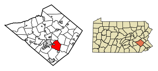
Berks County is a county in the Commonwealth of Pennsylvania. As of the 2020 census, the county's population was 428,849. The county seat is Reading, the fourth-most populous city in the state.

<span class="mw-page-title-main">Bally, Pennsylvania</span> Borough in Pennsylvania, United States

Bally is a borough in Berks County, Pennsylvania, United States. The population was 1,228 at the 2020 census.

<span class="mw-page-title-main">Boyertown, Pennsylvania</span> Borough in Pennsylvania, United States

Boyertown is a borough in Berks County, Pennsylvania, United States. The population was 4,264 at the 2020 census. Boyertown is known for the many painted fiberglass bears that can be found throughout the town and borough.

<span class="mw-page-title-main">Exeter Township, Berks County, Pennsylvania</span> Township in Pennsylvania, United States

Exeter Township is a township in Berks County, Pennsylvania, United States. The population was 25,500 as of the 2020 census, making it the third-most populous municipality in Berks County after the city of Reading and Spring Township. Daniel Boone Homestead is within its borders. This formerly rural township is now made up of mostly sprawl-oriented developments along U.S. Route 422 and Route 562 Its school district also contains the adjacent borough of St. Lawrence.

<span class="mw-page-title-main">Kutztown, Pennsylvania</span> Borough in Pennsylvania, United States

Kutztown is a borough in Berks County, Pennsylvania, United States. It is located 18 miles (29 km) southwest of Allentown and 17 miles (27 km) northeast of Reading. As of the 2020 census, the borough had a population of 4,162. Kutztown University of Pennsylvania is located just outside the borough limits to the southwest.

<span class="mw-page-title-main">Lenhartsville, Pennsylvania</span> Borough in Pennsylvania, United States

Lenhartsville is a borough in Berks County, Pennsylvania, United States. The population was 180 at the 2020 census.

<span class="mw-page-title-main">Lyons, Pennsylvania</span> Borough in Pennsylvania, United States

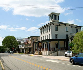
Lyons is a borough that is located in Berks County, Pennsylvania, United States. The population was 439 at the time of the 2020 census.

<span class="mw-page-title-main">Maxatawny Township, Pennsylvania</span> Township in Pennsylvania, United States

Maxatawny Township is a township in Berks County, Pennsylvania, United States. The population was 7,906 at the 2010 census.

<span class="mw-page-title-main">Muhlenberg Township, Berks County, Pennsylvania</span> Township in Pennsylvania, United States

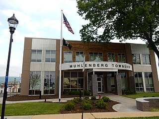
Muhlenberg Township is a township in Berks County, Pennsylvania, United States. The population was 21,915 at the 2020 census, making it the third-most populous township in Berks County after Spring Township and Exeter Township.

<span class="mw-page-title-main">Oley Township, Pennsylvania</span> Township in Pennsylvania, United States

Oley Township is a township in Berks County, Pennsylvania, United States. As of the 2010 census, the township had a population of 3,620. Oley Township was originally formed in 1740 as a part of Philadelphia County, before Berks County was formed in 1752. The entire township was listed as a historic district by the National Register of Historic Places in 1983. Oley is a Native American name purported to mean "a hollow". Daniel Boone was born in Oley Township November 2, 1734.

<span class="mw-page-title-main">Rockland Township, Berks County, Pennsylvania</span> Township in Pennsylvania, United States

Rockland Township is a township in Berks County, Pennsylvania, United States. The population was 3,778 at the 2010 census.

<span class="mw-page-title-main">Ruscombmanor Township, Pennsylvania</span> Township in Pennsylvania, United States

Ruscombmanor Township is a township in Berks County, Pennsylvania, United States. The population was 4,112 at the 2010 census.

<span class="mw-page-title-main">Shillington, Pennsylvania</span> Borough in Pennsylvania, United States

Shillington is a borough in Berks County, Pennsylvania, United States. With a population of 5,475 at the time of the 2020 census the borough is nestled amongst other suburbs outside Reading. It is perhaps best known for being the location of the homestead to Pennsylvania's first governor, Thomas Mifflin, and as the childhood home of American author John Updike. Many of Updike's stories take place in the fictional town of Olinger, a lightly-disguised version of Shillington, and in its environs.

<span class="mw-page-title-main">Shoemakersville, Pennsylvania</span> Borough in Pennsylvania, United States

Shoemakersville is a borough in Berks County, Pennsylvania, United States. The population was 1,360 at the 2020 census, a decline from the figure of 1,378 tabulated in 2010.

<span class="mw-page-title-main">St. Lawrence, Pennsylvania</span> Borough in Pennsylvania, United States

St. Lawrence, is a borough in Berks County, Pennsylvania, United States. The population was 1,892 at the 2020 census. It sits just east of Mount Penn and Reading. It is served by the Exeter Township School District.

<span class="mw-page-title-main">Elverson, Pennsylvania</span> Borough in Pennsylvania, United States

Elverson is a borough in Chester County, Pennsylvania, United States. The population was 1,332 at the 2020 census.

<span class="mw-page-title-main">Honey Brook, Pennsylvania</span> Borough in Pennsylvania, United States

Honey Brook is a borough in Chester County, Pennsylvania, United States. The population of the borough was 1,895 at the 2020 census. The borough is surrounded by Honey Brook Township, and both are referred to locally collectively as Honey Brook.

<span class="mw-page-title-main">Upper Macungie Township, Pennsylvania</span> Township in Pennsylvania, United States

Upper Macungie Township is a township in Lehigh County, Pennsylvania, United States. The population of Upper Macungie Township was 26,377 as of the 2020 U.S. census, making it the fourth-fastest growing municipality of any category in Pennsylvania in terms of total population growth between 2010 and 2020.

<span class="mw-page-title-main">Upper Hanover Township, Pennsylvania</span> Township in Pennsylvania, United States

Upper Hanover Township is a township in Montgomery County, Pennsylvania, United States. The population was 6,464 at the 2010 census.

References

  1. "ArcGIS REST Services Directory". United States Census Bureau. Retrieved October 12, 2022.
  2. 1 2 "Census Population API". United States Census Bureau. Retrieved Oct 12, 2022.
  3. 1 2 "Geographic Identifiers: 2010 Demographic Profile Data (G001): Fleetwood borough, Pennsylvania". U.S. Census Bureau, American Factfinder. Archived from the original on February 12, 2020. Retrieved March 6, 2014.
  4. "National Register Information System". National Register of Historic Places . National Park Service. July 9, 2010.
  5. "US Gazetteer files: 2010, 2000, and 1990". United States Census Bureau. 2011-02-12. Retrieved 2011-04-23.
  6. "Census of Population and Housing". U.S. Census Bureau. Retrieved 11 December 2013.
  7. 1 2 "U.S. Census website". United States Census Bureau . Retrieved 2008-01-31.
  8. "Incorporated Places and Minor Civil Divisions Datasets: Subcounty Resident Population Estimates: April 1, 2010 to July 1, 2012". Population Estimates. U.S. Census Bureau. Archived from the original on 11 June 2013. Retrieved 11 December 2013.
  9. "U.S. Census website" . Retrieved August 2, 2011.
  10. Orth, Richard L.T. (September 21, 2016). "A Look Back in History: The Old Order Mennonite Sect at Kutztown also preserving the Historic Oley Valley". BerksMont News. Retrieved October 15, 2017.
  11. Shaner, Richard (July 24, 2009). "Kutztown welcomes Old Order Mennonites in 1949". BerksMont News. Archived from the original on October 16, 2017. Retrieved October 15, 2017.
  12. "Fleetwood Borough map" (PDF). PennDOT. Retrieved March 13, 2023.
  13. "Route 22 schedule" (PDF). BARTA. Retrieved September 22, 2019.
  14. "Fleetwood, Pennsylvania" . Retrieved October 16, 2017.