Campion, Colorado

Last updated
Campion, Colorado
Larimer County Colorado Incorporated and Unincorporated areas Campion Highlighted.svg
Location of Campion in Larimer County, Colorado.
Usa edcp location map.svg
Red pog.svg
Campion
Location of Campion in the United States.
Coordinates: 40°20′58″N105°04′40″W / 40.3494282°N 105.0777585°W / 40.3494282; -105.0777585 Coordinates: 40°20′58″N105°04′40″W / 40.3494282°N 105.0777585°W / 40.3494282; -105.0777585 [1]
Country Flag of the United States.svg  United States
State Flag of Colorado.svg  State of Colorado
County Larimer County
Government
[1]
  Type unincorporated community
Elevation
[1]
5,115 ft (1,559 m)
Population
 (2000)
  Total1,832
Time zone UTC-7 (MST)
  Summer (DST) UTC-6 (MDT)
ZIP code
Loveland 80537
GNIS feature [1] Campion, Colorado

Campion is an unincorporated community located in southeastern Larimer County, Colorado, United States. [2] A former census-designated place (CDP), the population was 1,832 at the United States Census 2000. [2]

Contents

Etymology

Campion was named for John F. Campion, a railroad official. [3]

Geography

Campion is located between Loveland and Berthoud along U.S. Route 287.

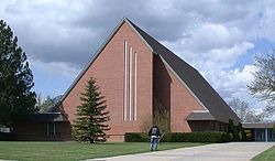
Church on the campus of Campion Academy DSCN2842 campionchurch e 600.jpg
Church on the campus of Campion Academy

Demographics

former Campion CDP, Colorado
YearPop.±%
1990 1,692    
2000 1,832+8.3%
Source: United States Census Bureau

See also

Related Research Articles

Larimer County, Colorado County in Colorado, United States

Larimer County is a county located in the U.S. state of Colorado. As of the 2020 census, the population was 359,066. The county seat and most populous city is Fort Collins. The county was named for William Larimer, Jr., the founder of Denver.

Derby, Colorado Census Designated Place in Colorado, United States

Derby is an unincorporated community and a census-designated place (CDP) located in and governed by Adams County, Colorado, United States. The CDP is a part of the Denver–Aurora–Lakewood, CO Metropolitan Statistical Area. The population of the Derby CDP was 8,407 at the United States Census 2020. The Commerce City post office serves the area.

Strasburg, Colorado Census Designated Place in Colorado, United States

Strasburg is an unincorporated town, a post office, and a census-designated place (CDP) located in and governed by Adams and Arapahoe counties, Colorado, United States. The CDP is a part of the Denver–Aurora–Lakewood, CO Metropolitan Statistical Area. The Strasburg post office has the ZIP Code 80136. At the United States Census 2010, the population of the Strasburg CDP was 2,447, while the population of the 80136 ZIP Code Tabulation Area was 4834 including adjacent communities.

Welby, Colorado Census Designated Place in Colorado, United States

Welby is an unincorporated community and a census-designated place (CDP) located in and governed by Adams County, Colorado, United States. The CDP is a part of the Denver–Aurora–Lakewood, CO Metropolitan Statistical Area. The population of the Welby CDP was 14,846 at the United States Census 2010. Denver post office 80229 serves the area.

Byers, Colorado Census Designated Place in Colorado, United States

Byers is an unincorporated town, a post office, and a census-designated place (CDP) located in and governed by Arapahoe County, Colorado, United States. The CDP is a part of the Denver–Aurora–Lakewood, CO Metropolitan Statistical Area. The Byers post office has the ZIP Code 80103. At the United States Census 2010, the population of the Byers CDP was 1,160, while the population of the 80103 ZIP Code Tabulation Area was 2,458 including adjacent areas.

Louviers, Colorado Census Designated Place in Colorado, United States

Louviers is an unincorporated town, a post office, and a census-designated place (CDP) located in and governed by Douglas County, Colorado, United States. The CDP is a part of the Denver–Aurora–Lakewood, CO Metropolitan Statistical Area. The Louviers post office has the ZIP Code 80131. At the United States Census 2010, the population of the Louviers CDP was 269, while the population of the 80131 ZIP Code Tabulation Area was 243.

Sedalia, Colorado Census Designated Place in Colorado, United States

Sedalia is an unincorporated town, a post office, and a census-designated place (CDP) located in and governed by Douglas County, Colorado, United States. The CDP is a part of the Denver–Aurora–Lakewood, CO Metropolitan Statistical Area. The Sedalia post office has the ZIP Code 80135. At the United States Census 2010, the population of the Sedalia CDP was 206, while the population of the 80135 ZIP Code Tabulation Area was 3,833 including adjacent areas.

Kittredge, Colorado Census Designated Place in Colorado, United States

Kittredge is an unincorporated town, a post office, and a census-designated place (CDP) located in and governed by Jefferson County, Colorado, United States. The CDP is a part of the Denver–Aurora–Lakewood, CO Metropolitan Statistical Area. The Kittredge post office has the ZIP code 80457. At the United States Census 2010, the population of the Kittredge CDP was 1,304, while the population of the 80457 ZIP Code Tabulation Area was 612.

Laporte, Colorado Census Designated Place in Colorado, United States

Laporte is an unincorporated town, a post office, and a census-designated place (CDP) located in and governed by Larimer County, Colorado, United States. The CDP is a part of the Fort Collins, CO Metropolitan Statistical Area. The Laporte post office has the ZIP Code 80535. At the United States Census 2010, the population of the Laporte CDP was 2,450, while the population of the 80535 ZIP Code Tabulation Area was 2,636 including adjacent areas.

Red Feather Lakes, Colorado Census Designated Place in Colorado, United States

Red Feather Lakes is an unincorporated town, a post office, and a census-designated place (CDP) located in and governed by Larimer County, Colorado, United States. The CDP is a part of the Fort Collins, CO Metropolitan Statistical Area. The Red Feather Lakes post office has the ZIP Code 80545. At the United States Census 2010, the population of the Red Feather Lakes CDP was 343, while the population of the 80545 ZIP Code Tabulation Area was 851 including adjacent areas.

Avondale, Colorado Census Designated Place in Colorado, United States

Avondale is an unincorporated town, a post office, and a census-designated place (CDP) located in and governed by Pueblo County, Colorado, United States. The CDP is a part of the Pueblo, CO Metropolitan Statistical Area. The Avondale post office has the ZIP Code 81022. At the United States Census 2020, the population of the Avondale CDP was 594, while the population of the 81022 ZIP Code Tabulation Area was 1,624 including adjacent areas.

Rollinsville, Colorado Census Designated Place in Colorado, United States

Rollinsville is an unincorporated town, a post office, and a census-designated place (CDP) located in and governed by Gilpin County, Colorado, United States. The CDP is a part of the Denver–Aurora–Lakewood, CO Metropolitan Statistical Area. The Rollinsville post office has the ZIP Code 80474. At the United States Census 2010, the population of the Rollinsville CDP was 181.

Divide, Colorado Census Designated Place in Colorado, United States

Divide is an unincorporated town, a post office, and a census-designated place (CDP) located in and governed by Teller County, Colorado, United States. The CDP is a part of the Colorado Springs, CO Metropolitan Statistical Area. The Divide post office has the ZIP Code 80814. At the United States Census 2010, the population of the Divide CDP was 127, while the population of the 80814 ZIP Code Tabulation Area was 4,023 including adjacent areas.

Watkins, Colorado Census Designated Place in Colorado, United States

Watkins is an unincorporated town and a census-designated place (CDP) located in and governed by Arapahoe and Adams counties, Colorado, United States. The CDP is a part of the Denver–Aurora–Lakewood, CO Metropolitan Statistical Area. The town is surrounded by Aurora and its post office, which lies within the Aurora city limits, has the ZIP Code 80137. At the United States Census 2010, the population of the Watkins CDP was 653, while the population of the 80137 ZIP Code Tabulation Area was 1,323 including adjacent communities.

Fort Collins – Loveland Metropolitan Statistical Area

The Fort Collins – Loveland Metropolitan Statistical Area is a United States Office of Management and Budget (OMB) defined Metropolitan Statistical Area (MSA) located in the Fort Collins and Loveland area in the North Central region of the U.S. state of Colorado. The Fort Collins–Loveland MSA is defined as Larimer County, Colorado. The Census Bureau estimates that the population was 310,487 in 2012, a 3.62% increase since 2010. The Fort Collins–Loveland MSA is the 151st most populous MSA in the United States.

Howard, Colorado Census Designated Place in Colorado, United States

Howard is an unincorporated town, a post office, and a census-designated place (CDP) located in and governed by Fremont County, Colorado, United States. The CDP is a part of the Cañon City, CO Micropolitan Statistical Area. The Howard post office has the ZIP Code 81233. At the United States Census 2010, the population of the Howard CDP was 723, while the population of the 81233 ZIP Code Tabulation Area was 823 including adjacent areas.

Matheson, Colorado Census Designated Place in Colorado, United States

Matheson is an unincorporated town, a post office, and a census-designated place (CDP) located in and governed by Elbert County, Colorado, United States. The CDP is a part of the Denver–Aurora–Lakewood, CO Metropolitan Statistical Area. The Matheson post office has the ZIP Code 80830. At the United States Census 2010, the population of the 80830 ZIP Code Tabulation Area was 254.

Leyner, Colorado Census Designated Place in Colorado, United States

Leyner is an unincorporated community and a census-designated place (CDP) located in and governed by Boulder County, Colorado, United States. The CDP is a part of the Boulder, CO Metropolitan Statistical Area. The population of the Leyner CDP was 29 at the United States Census 2010. The Lafayette post office serves the area.

Valmont, Colorado Census Designated Place in Colorado, United States

Valmont is an unincorporated community and a census-designated place (CDP) located in and governed by Boulder County, Colorado, United States. The CDP is a part of the Boulder, CO Metropolitan Statistical Area. The population of the Valmont CDP was 59 at the United States Census 2010. The Boulder post office serves the area.

Goldfield, Colorado Census Designated Place in Colorado, United States

Goldfield is an unincorporated community and a census-designated place (CDP) located in and governed by Teller County, Colorado, United States. The CDP is a part of the Colorado Springs, CO Metropolitan Statistical Area. The population of the Goldfield CDP was 49 at the United States Census 2010. The Cripple Creek post office (Zip Code 80813) serves the area.

References

  1. 1 2 3 4 "U.S. Board on Geographic Names: Domestic Names". United States Geological Survey . Retrieved December 11, 2020.
  2. 1 2 Colorado Trend Report 2: State and Complete Places (Sub-state 2010 Census Data). Archived 2012-07-11 at archive.today Missouri Census Data Center. Accessed 2011-02-25.
  3. Dawson, John Frank (1954). Place names in Colorado: why 700 communities were so named, 150 of Spanish or Indian origin. Denver, CO: The J. Frank Dawson Publishing Co. p. 12.