List of crossings of the Arkansas River

Last updated

This is a list of bridges and other crossings of the Arkansas River starting from the mouth at the Mississippi River upstream to its source in Colorado.

Contents

John Mack Bridge, which crosses the Arkansas River in Wichita, Kansas John Mack Bridge.JPG
John Mack Bridge, which crosses the Arkansas River in Wichita, Kansas

Crossings

CrossingCarriesLocationCoordinates

Arkansas

Yancopin Bridge Abandoned Rail Watson 33°57′19″N91°12′22″W / 33.955304°N 91.206075°W / 33.955304; -91.206075 (Yancopin Bridge)
Wilbur D. Mills Dam Arkansas Post 33°59′20″N91°18′48″W / 33.988940°N 91.313290°W / 33.988940; -91.313290 (Wilbur D. Mills Dam)
Pendleton BridgeUS 165 (AR).svg US 165 33°58′49″N91°23′05″W / 33.980271°N 91.384621°W / 33.980271; -91.384621 (Pendleton Bridge)
Joe Hardin Lock and Dam 3 Grady 34°09′46″N91°40′48″W / 34.162848°N 91.679878°W / 34.162848; -91.679878 (Joe Hardin Lock and Dam 3)
Emmett Sanders Lock and Dam 4 Pine Bluff 34°14′56″N91°54′13″W / 34.248850°N 91.903728°W / 34.248850; -91.903728 (Emmett Sanders Lock and Dam 4)
Lawrence Blackwell Bridge US 63 (AR).svgUS 79 (AR).svg US 63  / US 79 34°14′56″N91°54′13″W / 34.248850°N 91.903728°W / 34.248850; -91.903728 (Lawrence Blackwell Bridge)
Rob Roy BridgeRail 34°16′01″N91°54′45″W / 34.267023°N 91.912394°W / 34.267023; -91.912394 (Rob Roy Bridge)
79-B BridgeUS 79 (AR).svg US 79 34°17′23″N91°59′49″W / 34.289697°N 91.997019°W / 34.289697; -91.997019 (79-B Bridge)
Lock and Dam #5 Redfield 34°24′43″N92°06′10″W / 34.411867°N 92.102852°W / 34.411867; -92.102852 (Lock and Dam #5)
Pipeline bridge 34°28′47″N92°07′26″W / 34.479852°N 92.123966°W / 34.479852; -92.123966 (Pipeline bridge)
David D. Terry Lock & Dam 6 Little Rock 34°40′02″N92°09′25″W / 34.667241°N 92.157054°W / 34.667241; -92.157054 (David D. Terry Lock & Dam 6)
I-440 BridgeI-440.svg I-440 34°43′26″N92°10′40″W / 34.723874°N 92.177892°W / 34.723874; -92.177892 (I-440 Bridge)
Rock Island BridgeAbandoned Rail 34°44′59″N92°15′32″W / 34.749749°N 92.258817°W / 34.749749; -92.258817 (Rock Island Bridge)
I-30 BridgeI-30.svg I-30 34°45′01″N92°15′46″W / 34.750263°N 92.262732°W / 34.750263; -92.262732 (Junction Bridge)
Junction Bridge 34°45′03″N92°15′59″W / 34.750843°N 92.266402°W / 34.750843; -92.266402 (Junction Bridge)
Main Street Bridge 34°45′04″N92°16′08″W / 34.751202°N 92.268925°W / 34.751202; -92.268925 (Main Street Bridge)
Broadway Bridge US 70 (AR).svg US 70 34°45′09″N92°16′27″W / 34.752368°N 92.274213°W / 34.752368; -92.274213 (Broadway Bridge)
Baring Cross BridgeUnion Pacific Railroad 34°45′16″N92°16′55″W / 34.754448°N 92.281981°W / 34.754448; -92.281981 (Union Pacific Rail bridge)
Murray Lock and Dam (Big Dam Bridge) Sweden road sign H17.svg Longest pedestrian bridge in US 34°47′37″N92°21′31″W / 34.793647°N 92.358541°W / 34.793647; -92.358541 (Murray Lock and Dam)
I-430 BridgeI-430.svg I-430 34°48′02″N92°22′28″W / 34.800598°N 92.374485°W / 34.800598; -92.374485 (I-430 Bridge)
Toad Suck Ferry Lock and DamArkansas 60.svg AR 60 Conway 35°04′39″N92°32′31″W / 35.077372°N 92.541830°W / 35.077372; -92.541830 (Toad Suck Ferry Lock and Dam)
Highway 9 BridgeArkansas 9.svgArkansas 113.svg AR 9  / AR 113 Morrilton 35°07′34″N92°43′58″W / 35.126041°N 92.732812°W / 35.126041; -92.732812 (Highway 9 Bridge)
Arthur V. Ormond Lock & Dam 9 35°07′32″N92°47′16″W / 35.12563°N 92.787641°W / 35.12563; -92.787641 (Arthur V. Ormond Lock & Dam 9)
Highway 7 BridgeArkansas 7.svg AR 7 Russellville 35°13′33″N93°09′02″W / 35.225720°N 93.150480°W / 35.225720; -93.150480 (Highway 7 Bridge)
Dardanelle Lock & Dam 10 35°14′57″N93°10′15″W / 35.249124°N 93.170757°W / 35.249124; -93.170757 (Dardanelle Lock & Dam 10)
Morrison Bluff Bridge; also known as Ada Mills BridgeArkansas 109.svg AR 109 Arkansas Longest Bridge Morrison Bluff 35°24′40″N93°31′55″W / 35.411221°N 93.532038°W / 35.411221; -93.532038 (Morrison Bluff Bridge)
Ozark-Jeta Taylor Lock & Dam 12 Ozark 35°28′19″N93°48′50″W / 35.472012°N 93.813962°W / 35.472012; -93.813962 (Ozark-Jeta Taylor Lock & Dam 12)
Ozark BridgeArkansas 23.svg AR 23 35°28′57″N93°49′58″W / 35.482530°N 93.832737°W / 35.482530; -93.832737 (Ozark Bridge)
James W. Trimble Lock & Dam 13Arkansas 59.svg AR 59 Barling 35°21′06″N94°17′47″W / 35.351617°N 94.296520°W / 35.351617; -94.296520 (James W. Trimble Lock & Dam 13)
I-540 BridgeI-540.svg I-540 Fort Smith 35°25′17″N94°20′57″W / 35.421410°N 94.349240°W / 35.421410; -94.349240 (I-540 Bridge)
BridgeUS 64 (AR).svg US 64 35°25′42″N94°21′34″W / 35.428305°N 94.359437°W / 35.428305; -94.359437 (Bridge)
Fort Smith Frisco BridgeArkansas & Missouri tourist railroad 35°25′58″N94°21′53″W / 35.432806°N 94.364721°W / 35.432806; -94.364721 (Arkansas & Missouri tourist railroad Arkansas RiverBridge)

Arkansas - Oklahoma

Lyle Rymer Highway BridgeUS 64.svg US 64 Fort Smith 35°23′32″N94°25′58″W / 35.392289°N 94.432718°W / 35.392289; -94.432718 (Lyle Rymer Highway Bridge)

Oklahoma

W. D. Mayo Lock & Dam 14No bridge Spiro 35°18′58″N94°33′31″W / 35.316071°N 94.558704°W / 35.316071; -94.558704 (W. D. Mayo Lock & Dam 14)
Rail Bridge Kansas City Southern Railway 35°18′03″N94°37′15″W / 35.300836°N 94.620781°W / 35.300836; -94.620781 (Kansas City Southern Rail Bridge)
US 59 BridgeUS 59.svg US 59 Sallisaw 35°21′00″N94°46′19″W / 35.350046°N 94.771984°W / 35.350046; -94.771984 (US 59 Arkansas River Bridge)
Robert S. Kerr Lock & Dam 15No bridge 35°20′39″N94°46′31″W / 35.344290°N 94.775360°W / 35.344290; -94.775360 (Robert S. Kerr Lock & Dam 15)
I-40 Bridge I-40.svg I-40, bridge disaster Gore 35°29′12″N95°05′52″W / 35.486648°N 95.097705°W / 35.486648; -95.097705 (I-40 Arkansas River Bridge)
US 64 BridgeUS 64.svgOklahoma State Highway 100.svg US 64  / SH-100 35°31′10″N95°07′33″W / 35.519340°N 95.125962°W / 35.519340; -95.125962 (Lyle Rymer Highway Bridge)
Webbers Falls Lock and Dam 16No bridge 35°33′15″N95°10′08″W / 35.554033°N 95.16881°W / 35.554033; -95.16881 (Webbers Falls Lock and Dam 16)
US 62 BridgeUS 62.svg US 62 Muskogee 35°46′12″N95°17′58″W / 35.769962°N 95.299505°W / 35.769962; -95.299505 (US 62 Bridge)
Muskogee Turnpike bridge Muskogee Turnpike 35°47′51″N95°19′00″W / 35.797383°N 95.316601°W / 35.797383; -95.316601 (Muskogee Turnpike overpass over Arkansas River)
York Street BridgeOklahoma State Highway 16.svg SH-16 35°47′38″N95°20′03″W / 35.793985°N 95.334143°W / 35.793985; -95.334143 (York Street Bridge)
Old OK 16 (Jefferson Highway)(Abandoned) 35°47′38″N95°20′03″W / 35.793985°N 95.334143°W / 35.793985; -95.334143 (Old OK 16 (Jefferson Highway))
2 Rail Bridges Union Pacific Railroad 35°47′38″N95°20′03″W / 35.793985°N 95.334143°W / 35.793985; -95.334143 (Muskogee UPRR Bridges)
US 69 OverpassUS 69.svg US 69 35°48′24″N95°24′07″W / 35.806803°N 95.401936°W / 35.806803; -95.401936 (US Highway 69 Arkansas River Bridge)
Old OK 104 BridgeFormer Oklahoma State Highway 104.svg SH-104 Haskell 35°49′15″N95°38′29″W / 35.820824°N 95.641270°W / 35.820824; -95.641270 (Old OK 104 Bridge)
Oklahoma Highway 104 BridgeOklahoma State Highway 104.svg SH-104 35°49′19″N95°38′30″W / 35.821941°N 95.641790°W / 35.821941; -95.641790 (OK 104 Bridge)
Lt Col Ernest Childers Hwy BridgeOklahoma State Highway 72.svg SH-72 Coweta 35°55′08″N95°39′25″W / 35.919026°N 95.656982°W / 35.919026; -95.656982 (OK 104 Bridge)
Memorial Drive BridgeUS 64.svg US 64 Bixby 35°57′28″N95°53′11″W / 35.957687°N 95.886400°W / 35.957687; -95.886400 (Memorial Drive Bridge)
Old US 64 Bridge Sweden road sign H17.svg Pedestrian Bridge 35°57′28″N95°53′11″W / 35.957687°N 95.886400°W / 35.957687; -95.886400 (Old US 64 Pedestrian Bridge)
Creek Turnpike Bridge Creek Turnpike Jenks-Tulsa 36°01′06″N95°57′11″W / 36.018274°N 95.953062°W / 36.018274; -95.953062 (Creek Turnpike Bridge)
96th Street BridgeE 96th St (Tulsa)
E Main St (Jenkins)
36°01′29″N95°57′18″W / 36.024678°N 95.954885°W / 36.024678; -95.954885 (96th Street - Main St Bridge)
Jenks Bridge Sweden road sign H17.svg Pedestrian Bridge 36°01′29″N95°57′18″W / 36.024678°N 95.954885°W / 36.024678; -95.954885 (Riverwalk Crossing)
71st Street Bridge71st Street Tulsa 36°03′39″N95°58′52″W / 36.060819°N 95.980976°W / 36.060819; -95.980976 (71st Street Bridge)
I-44 BridgeI-44.svg I-44 36°05′23″N95°59′18″W / 36.089794°N 95.988408°W / 36.089794; -95.988408 (I-44 Arkansas River Bridge)
Zink DamLow-Water Dam 36°07′14″N95°59′19″W / 36.120544°N 95.988686°W / 36.120544; -95.988686 (Zink Dam)
Midland Valley Railroad bridge Sweden road sign H17.svg Pedestrian Bridge 36°07′14″N95°59′19″W / 36.120544°N 95.988686°W / 36.120544; -95.988686 (Midland Valley Railroad Arkansas River bridge)
23rd Street BridgeW 23rd Street 36°07′53″N95°59′34″W / 36.131501°N 95.992916°W / 36.131501; -95.992916 (23rd Street Bridge)
11th Street Bridge Former US 66.svg US 66 bridge(Abandoned; Closed to all traffic) 36°08′34″N96°00′16″W / 36.142642°N 96.004551°W / 36.142642; -96.004551 (11th Street Bridge)
I-244 (2 Bridges)I-244 (long).svgUS 75.svg I-244  / US 75 36°08′34″N96°00′18″W / 36.142714°N 96.005053°W / 36.142714; -96.005053 (I-244 Arkansas River Bridge)
BNSF RR Bridge BNSF Railway 36°08′36″N96°00′22″W / 36.14342°N 96.006056°W / 36.14342; -96.006056 (BNSF Railway Arkansas River Bridge)
Oklahoma Highway 97/51 BridgeOklahoma State Highway 51.svgOklahoma State Highway 97.svg SH-51  / SH-97 Sand Springs 36°03′39″N95°58′52″W / 36.060819°N 95.980976°W / 36.060819; -95.980976 (Oklahoma Highway 97/51 Bridge)
Keystone Dam Oklahoma State Highway 151.svg SH-151 36°08′34″N96°00′16″W / 36.142642°N 96.004551°W / 36.142642; -96.004551 (Oklahoma Keystone Dam)

Kansas

BridgeI-35.svg I-35 ( Kansas Turnpike ) Wichita 37°37′30″N97°17′52″W / 37.624906°N 97.297642°W / 37.624906; -97.297642 (bridge)
John Mack Bridge South Broadway 37°38′41″N97°20′07″W / 37.644722°N 97.335278°W / 37.644722; -97.335278 (bridge)

Colorado

SH 89 BridgeColorado 89.svg SH 89 Prowers County 38°05′42″N102°18′39″W / 38.0949°N 102.3107°W / 38.0949; -102.3107 (SH 89 Arkansas Bridge)
US 385 BridgeUS 385.svg US 385 38°29′11″N105°22′24″W / 38.4864°N 105.3732°W / 38.4864; -105.3732 (US 385 Arkansas Bridge)
Main St BridgeUS 50.svgUS 287.svg US 50  / US 287 (Main Street) Lamar 38°06′20″N102°37′06″W / 38.1056°N 102.6184°W / 38.1056; -102.6184 (US 287/50 Arkansas Bridge)
Bent Ave BridgeUS 50.svg US 50 (Bent Avenue) Las Animas 38°04′56″N103°13′12″W / 38.08211°N 103.2200°W / 38.08211; -103.2200 (Bent Ave Arkansas Bridge)
Adams Ave, Main St BridgeColorado 109 wide.svg SH 109 La Junta 37°59′27″N103°31′54″W / 37.9907°N 103.5318°W / 37.9907; -103.5318 (SH 109, Adams Ave Arkansas Bridge)
SH 266 BridgeColorado 266 wide.svg SH 266 Rocky Ford 38°03′53″N103°41′06″W / 38.0646°N 103.6849°W / 38.0646; -103.6849 (SH 266 Arkansas Bridge)
SH 71 BridgeColorado 71.svg SH 71 38°06′23″N103°44′51″W / 38.1064°N 103.7475°W / 38.1064; -103.7475 (SH 71 Arkansas Bridge)
SH 207 BridgeColorado 207 wide.svgColorado 266 wide.svg SH 207  / SH 266 Manzanola 38°07′38″N103°51′43″W / 38.1272°N 103.8620°W / 38.1272; -103.8620 (SH 207 Arkansas Bridge)
SH 167 BridgeColorado 167 wide.svg SH 167 Fowler 38°08′28″N104°01′22″W / 38.1411°N 104.0227°W / 38.1411; -104.0227 (SH 167 Arkansas Bridge)
US 50 BridgeUS 50.svg US 50 Avondale 38°14′41″N104°20′38″W / 38.24485°N 104.3440°W / 38.24485; -104.3440 (US 50 Avondale Arkansas Bridge)
Avondale Blvd Bridge Avondale Blvd 38°14′32″N104°20′57″W / 38.2422°N 104.3491°W / 38.2422; -104.3491 (Avondale Blvd Arkansas Bridge)
36th Lane BridgeColorado 231 wide.svg SH 231 (36th Lane) Pueblo County 38°16′00″N104°27′27″W / 38.2666°N 104.4576°W / 38.2666; -104.4576 (SH 231 Arkansas Bridge)
Baxter Rd BridgeColorado 233 wide.svg SH 233 (Baxter Road) 38°15′29″N104°29′48″W / 38.2581°N 104.4966°W / 38.2581; -104.4966 (SH 233 Arkansas Bridge)
La Crosse Ave BridgeColorado 227 wide.svg SH 227 (La Crosse Avenue) Pueblo 38°15′14″N104°35′19″W / 38.2538°N 104.5885°W / 38.2538; -104.5885 (La Crosse Ave Bridge)
Santa Fe BridgeUS 50.svg US 50 (Santa Fe Avenue) 38°15′16″N104°36′24″W / 38.2544°N 104.6067°W / 38.2544; -104.6067 (Santa Fe Ave Bridge)
I-25, Highway 85/87 BridgeI-25.svgUS 85.svgUS 87.svg I-25  / US 85  / US 87 38°15′18″N104°36′28″W / 38.2551°N 104.6079°W / 38.2551; -104.6079 (I-25 Arkansas River Bridge)
4th St BridgeColorado 96.svg SH 96 (W 4th Street) 38°16′08″N104°37′26″W / 38.2688°N 104.6239°W / 38.2688; -104.6239 (W 4th Street Bridge)
Pueblo Blvd BridgeColorado 45.svg SH 45 (Pueblo Boulevard) 38°16′07″N104°39′44″W / 38.2686°N 104.6621°W / 38.2686; -104.6621 (Pueblo Blvd Bridge)
Juniper BridgeJuniper Rd 38°16′16″N104°43′09″W / 38.2710°N 104.7193°W / 38.2710; -104.7193 (Juniper Rd Bridge)
Colorado 120 BridgeColorado 120 wide.svg SH 120 Portland 38°N105°W / 38°N 105°W / 38; -105 (Colorado 120 Bridge)
Colorado 67 BridgeColorado 67.svg SH 67 (Pikes Peak Avenue) Florence 38°N105°W / 38°N 105°W / 38; -105 (Colorado 120 Bridge)
Mac Kenzie Boulevard BridgeMac Kenzie Boulevard Cañon City 38°N105°W / 38°N 105°W / 38; -105 (Mac Kenzie Blvd Bridge)
Raynolds Ave BridgeRaynolds Avenue 38°N105°W / 38°N 105°W / 38; -105 (Raynolds Ave Bridge)
South 9th St BridgeColorado 115 wide.svg SH 115 (South 9th Street) 38°N105°W / 38°N 105°W / 38; -105 (South 9th St Bridge)
"Black Bridge" Railroad BridgeRailroad 38°N105°W / 38°N 105°W / 38; -105 (Black Bridge)
Arkansas Riverwalk BridgeArkansas Riverwalk 38°N105°W / 38°N 105°W / 38; -105 (Arkansas Riverwalk Bridge)
South 4th St Bridge and ViaductSouth 4th Street 38°N105°W / 38°N 105°W / 38; -105 (South 4th St Bridge)
Historic South 4th St BridgeArkansas Riverwalk 38°N105°W / 38°N 105°W / 38; -105 (Historic South 4th St Bridge)
South 1st St BridgeSouth 1st Street 38°N105°W / 38°N 105°W / 38; -105 (South 1st St Bridge)
Royal Gorge Bridge [lower-alpha 1] Sweden road sign H17.svg Pedestrian tourist bridge 38°27′41″N105°19′31″W / 38.4614°N 105.3253°W / 38.4614; -105.3253 (Royal Gorge Bridge)
US 50 bridgeUS 50.svg US 50 Fremont County 38°29′11″N105°22′24″W / 38.4864°N 105.3732°W / 38.4864; -105.3732 (US 50 Arkansas Bridge)
W 1st St.Colorado 291 wide.svg SH 291 (W 1st Street) Salida 38°32′46″N106°00′33″W / 38.5462°N 106.0091°W / 38.5462; -106.0091 (SH 291 Arkansas Bridge)
US 291 BridgeColorado 291 wide.svg SH 291 Chaffee County 38°36′30″N106°03′53″W / 38.6083°N 106.0646°W / 38.6083; -106.0646 (SH 291 Arkansas Bridge)
US 285/24 BridgeUS 24.svgUS 285.svg US 24  / US 285 39°48′47″N106°06′15″W / 39.8131°N 106.1043°W / 39.8131; -106.1043 (US 285 Arkansas Bridge)
SH 91 BridgeColorado 91.svg SH 91
First bridge over Arkansas
Summit County 39°21′39″N106°10′44″W / 39.3607°N 106.1790°W / 39.3607; -106.1790 (SH 91 Arkansas Bridge)

See also

Notes

  1. The Royal Gorge Bridge crosses 955 feet (291 m) above the Arkansas River.

Related Research Articles

<span class="mw-page-title-main">Mississippi River</span> Major river in the United States

The Mississippi River is the primary river, and second-longest river, of the largest drainage basin in the United States. From its traditional source of Lake Itasca in northern Minnesota, it flows generally south for 2,340 miles (3,766 km) to the Mississippi River Delta in the Gulf of Mexico. With its many tributaries, the Mississippi's watershed drains all or parts of 32 U.S. states and two Canadian provinces between the Rocky and Appalachian mountains. The main stem is entirely within the United States; the total drainage basin is 1,151,000 sq mi (2,980,000 km2), of which only about one percent is in Canada. The Mississippi ranks as the thirteenth-largest river by discharge in the world. The river either borders or passes through the states of Minnesota, Wisconsin, Iowa, Illinois, Missouri, Kentucky, Tennessee, Arkansas, Mississippi, and Louisiana.

<span class="mw-page-title-main">Great River Road</span> Highway designation

The Great River Road is a collection of state and local roads that follow the course of the Mississippi River through ten states of the United States. They are Minnesota, Wisconsin, Iowa, Illinois, Missouri, Kentucky, Tennessee, Arkansas, Mississippi and Louisiana. It formerly extended north into Canada, serving the provinces of Ontario and Manitoba. The road is designated as both a National Scenic Byway and an All-American Road in several states along the route.

<span class="mw-page-title-main">Arkansas River</span> Major tributary of the Mississippi River, United States

The Arkansas River is a major tributary of the Mississippi River. It generally flows to the east and southeast as it traverses the U.S. states of Colorado, Kansas, Oklahoma, and Arkansas. The river's source basin lies in Colorado, specifically the Arkansas River Valley. The headwaters derive from the snowpack in the Sawatch and Mosquito mountain ranges. It flows east into Kansas and finally through Oklahoma and Arkansas, where it meets the Mississippi River.

<span class="mw-page-title-main">U.S. Route 82</span> Highway in the United States

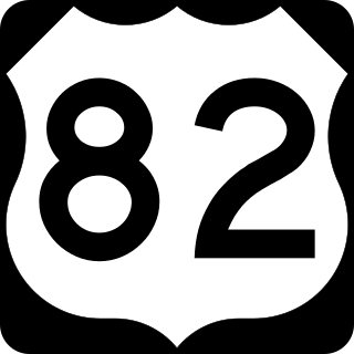
U.S. Route 82 is an east–west United States highway in the Southern United States. Created on July 1, 1931 across central Mississippi and southern Arkansas, US 82 eventually became a 1,625-mile-long (2,615 km) route extending from the White Sands of New Mexico to Georgia's Atlantic coast.

<span class="mw-page-title-main">United States National Register of Historic Places listings</span> Register for landmarks in the United States

The National Register of Historic Places in the United States is a register including buildings, sites, structures, districts, and objects. The Register automatically includes all National Historic Landmarks as well as all historic areas administered by the U.S. National Park Service. Since its introduction in 1966, more than 90,000 separate listings have been added to the register.

<span class="mw-page-title-main">Natchez–Vidalia Bridge</span> Bridge in Louisiana and Natchez, Mississippi

The Natchez–Vidalia Bridge are two twin cantilever bridges carrying U.S. Route 84, and 425 across the Mississippi River between Vidalia, Louisiana and Natchez, Mississippi. It is the tallest bridge in Mississippi.

<span class="mw-page-title-main">Greenville Bridge</span> Bridge in United States of America

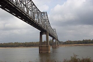
The Greenville Bridge, or the Jesse Brent Memorial Bridge, is a cable-stayed bridge over the Mississippi River, in the United States, carrying US 82 and US 278 between Refuge, Mississippi, and Shives, Arkansas. When it opened in 2010, it was the fourth-longest cable-stayed bridge in North America.

<span class="mw-page-title-main">Benjamin G. Humphreys Bridge</span> Former highway bridge over the Mississippi River

The Benjamin G. Humphreys Bridge was a two-lane cantilevered truss bridge carrying U.S. Route 82/U.S. Route 278 across the Mississippi River between Lake Village, Arkansas and Greenville, Mississippi. It was the first bridge to connect the two towns. The bridge was named for Benjamin G. Humphreys II, a former United States Congressman from Greenville.

<span class="mw-page-title-main">Helena Bridge</span> Bridge in Arkansas and Lula, Mississippi

The Helena Bridge is a cantilever bridge carrying U.S. Route 49 across the Mississippi River between Helena, Arkansas and Lula, Mississippi.

<span class="mw-page-title-main">Memphis & Arkansas Bridge</span> Highway bridge in Memphis, Tennessee, United States

The Memphis & Arkansas Bridge, also known as the Memphis–Arkansas Bridge or inaccurately as the Memphis–Arkansas Memorial Bridge, is a cantilevered through truss bridge carrying Interstate 55 across the Mississippi River between West Memphis, Arkansas and Memphis, Tennessee. Memphians refer to this bridge as the "Old Bridge" to distinguish it from the "New Bridge", or Hernando de Soto Bridge, upstream.

<span class="mw-page-title-main">Frisco Bridge</span> Bridge in Arkansas and Memphis, Tennessee

The Frisco Bridge, previously known as the Memphis Bridge, is a cantilevered through truss bridge carrying a rail line across the Mississippi River between West Memphis, Arkansas, and Memphis, Tennessee.

<span class="mw-page-title-main">Harahan Bridge</span> Bridge between Arkansas and Tennessee, US

The Harahan Bridge is a cantilevered through truss bridge that carries two rail lines and a pedestrian bridge across the Mississippi River between West Memphis, Arkansas, and Memphis, Tennessee. The bridge is owned and operated by Union Pacific Railroad and is the second longest pedestrian/bicycle bridge in the United States. It was built with roadways cantilevered off the sides of the main structure for vehicles. These roadways are owned by the cities of Memphis, Tennessee, and Crittenden County, Arkansas, and were used from 1917–1949, until the Memphis & Arkansas Bridge opened 400 feet (120 m) south of the Harahan. The bridge was named in honor of railroad executive James Theodore Harahan, former president of the Illinois Central Railroad, who was killed in a railroad accident during the construction of the bridge. In February 2011, Union Pacific Railroad officials agreed to the idea of converting the 1917 roadways into a bicycle-pedestrian walkway across the river. In June 2012, Memphis was awarded a $14.9 million federal grant to build the walkway. The overall project was expected to cost $30 million, of which about $11 million was used for the Harahan Bridge portion. Construction was completed in 2016.

<span class="mw-page-title-main">Hernando de Soto Bridge</span> Steel-arch bridge between West Memphis, Arkansas, and Memphis, Tennessee, US

The Hernando de Soto Bridge is a tied-arch bridge carrying Interstate 40 across the Mississippi River between West Memphis, Arkansas, and Memphis, Tennessee. The design is a continuous cantilevered cable-stayed steel through arch, with bedstead endposts. Memphians also call the bridge the "New Bridge", as it is newer than the Memphis & Arkansas Bridge downstream, and the "M Bridge", due to its distinctive shape. It is of similar construction to the Sherman Minton Bridge between Louisville, Kentucky, and New Albany, Indiana.

<span class="mw-page-title-main">Arkansas Highway 2</span> Former state highway in Arkansas

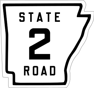
State Road 2 is a former east–west state highway in the Arkansas Timberlands and Lower Arkansas Delta. The route was approximately 195 miles (314 km), and ran from US Route 67 (US 67) in Texarkana east to cross the Mississippi River near Lake Village, continuing as Mississippi Highway 10. On July 1, 1931, the route was entirely replaced by US Highway 82 (US 82) by the American Association of State Highway Officials (AASHTO). The route was maintained by the Arkansas Highway Department (AHD), now known as the Arkansas Department of Transportation (ArDOT).

<span class="mw-page-title-main">U.S. Route 50 in Colorado</span> Section of U.S. Highway in Colorado, United States

U.S. Route 50 (US 50) is a part of the U.S. Highway System that travels from West Sacramento, California, to Ocean City, Maryland. In the U.S. state of Colorado, US 50 is a major highway crossing through the lower midsection of the state. It connects the Western Slope with the lower Front Range and the Arkansas Valley. The highway serves the areas of Pueblo and Grand Junction as well as many other smaller areas along its corridor. The long-term project to widen the highway from two lanes to a four lane expressway between Grand Junction and Montrose was completed in January 2005. Only about 25% of the remainder of highway 50 in Colorado is four lane highway.

<span class="mw-page-title-main">Transportation in Memphis, Tennessee</span>

Memphis, Tennessee has developed into a major Mid-American commercial and transportation hub because of its location on the Mississippi River and a convergence of numerous rail and highway links. Four rail and highway bridges cross the Mississippi River at Memphis. In addition, Memphis International Airport has become the world's largest airfreight terminal.

<span class="mw-page-title-main">Avondale Bridge (Arkansas River)</span> United States historic place

Avondale Bridge was located in Avondale, Colorado spanning the Arkansas River. It was listed on the National Historic Register of Places. It was a Luten Arch bridge built by the Pueblo Bridge Co. It was replaced in 2005.