
Chennai, also known as Madras, is the capital city of the Indian state of Tamil Nadu. The state's largest city in area and population as well, Chennai is located on the Coromandel Coast of the Bay of Bengal, and is the most prominent cultural, economic and educational centre of South India.

Adyar, or Adaiyaaru, is a large neighbourhood in south Chennai, Tamil Nadu, India. It is located on the southern banks of the Adyar River. It is surrounded by the Tharamani in the West, Thiruvanmiyur to the South, Besant Nagar in the East, Kotturpuram in the North-West and Raja Annamalai puram in the North past the Adyar River. Adyar is one of the costliest areas in Chennai with property values four times the value of similar sized properties in the northern part of Chennai. The Gandhi Nagar region of Adyar is one of the poshest localities in Chennai.

The Greater Chennai Corporation, formerly known as the Corporation of Madras (1668-1996) and Corporation of Chennai (1996-2016), is the civic body that governs the city of Chennai in the Indian state of Tamil Nadu. Inaugurated on 29 September 1688, under a royal charter issued by King James II of England on 30 December 1687 as the Corporation of Madras, it is the oldest municipal body of the Commonwealth of Nations outside Great Britain. It is among the oldest municipalities in Asia after Daman Municipality, which was established in 1588. It is the largest municipal corporation is Tamil Nadu with an area of 426 km2. It is headed by a mayor, who presides over 200 councillors, each of whom represents one of the 200 wards of the city. It is the second oldest civic corporation in the world after the City of London.

Thyagaraya Nagar, commonly known as T. Nagar, is a very affluent commercial and residential neighbourhood in Chennai, Tamil Nadu, India. It is surrounded by Nungambakkam in the North, Teynampet in the East, Nandanam in the South-East, C.I.T. Nagar in the South and West Mambalam and Kodambakkam in the West. The stretch between Duraiswamy Road and T. Nagar Bus Stand has some of the costliest real estates in Chennai. It was constructed between 1923 and 1925 by the Madras Presidency government of the Raja of Panagal as a part of town planning activities initiated according to the Madras Town Planning Act of 1920. The town was named after P. Thyagaraya Chetty. The streets, parks and localities in the new neighbourhood were named after important officials in the provincial government.

Tambaram is a southern suburb of Chennai. Located within the Chengalpattu district of Tamil Nadu, it is governed by Tambaram Municipal Corporation and is a part of the Chennai Metropolitan Area.

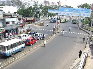
Transport in Chennai includes various modes of air, sea, road and rail transportation in the city and its suburbs. Chennai's economic development has been closely tied to its port and transport infrastructure, and it is considered one of the best infrastructure systems in India.
Ambattur is located in north west part of Chennai City, in Ambattur taluk of the Chennai District, surrounded by Avadi, Anna Nagar, Padi, Mogappair, Kallikuppam, Surapet, Korattur, Ayappakkam, and Thiruverkadu. It covers an area of 45 km2 (17 sq mi). The neighbourhood is served by Ambattur railway station of the Chennai Suburban Railway. Ambattur has its origins in a village of the same name which can be located at present as areas opposite to Ambattur telephone exchange. Ambattur was a village with large extents of agricultural farm lands irrigated by the once-sprawling Ambattur Lake. In 2011, the neighbourhood had a population 466,205.

Anna Nagar, is a neighbourhood in the metropolitan city of Chennai, India. Named after former chief minister of Tamil Nadu C. N. Annadurai, it is located in the north-western part of Chennai and forms a part of the Aminjikarai taluk and the Anna Nagar Zone. It is one of the prime residential areas in Chennai and is home to several prominent doctors, lawyers and politicians. Real estate prices are among the highest in the city. A recent addition to the area is VR Chennai Mall, located near Shanthi Colony and Thirumangalam junction.

Nungambakkam is a locality in downtown Chennai, India. The neighborhood abounds with multi-national commercial establishments, important government offices, foreign consulates, sprawling educational institutions, shopping malls, sporting facilities, tourist spots, star hotels, restaurants, and cultural centers. Nungambakkam is also a prime residential area in Chennai. The adjoining regions of Nungambakkam include Egmore, Chetpet, T. Nagar, Kodambakkam, Choolaimedu and Kilpauk.

Saidapet, also known as Saidai, is a neighbourhood in Chennai, India, situated in the northern banks of the Adyar River and serves as an entry point to Central Chennai. It is surrounded by West Mambalam in the North, C.I.T Nagar in the North-East, Nandanam in the East, Guindy in the South, Jafferkhanpet and Ashok Nagar in the North-West. The Saidapet Court, the only other court of judicature in Chennai city apart from the Madras High Court, and the Saidapet bus depot are located here. Prior to its incorporation in Madras city, Saidapet functioned as the administrative headquarters of Chingleput district. The neighbourhood is served by Saidapet railway station of the Chennai Suburban Railway Network.
Pammal is a suburban neighbourhood of Chennai, Tamil Nadu, India. It is located 22 kilometers from Chennai Central Railway Station. It is located next to Pallavaram on the western side. It lies on the western side of the Grand Southern Trunk Road and close to Chennai International Airport. It is 7 kilometers away from Tambaram. The neighborhood is served by Pallavaram Railway Station of the Chennai Suburban Railway Network. Pammal falls under Chengalpattu District.
Choolaimedu is a large residential and commercial locality in Chennai, Tamilnadu, India. It borders Kodambakkam, Vadapalani, M.M.D.A. Colony, Aminjikarai, Mahalingapuram and Nungambakkam. Previously a part of Puliyur village, Kodambakkam, Choolaimedu has now become a hub for commercial interests and connects two of the busiest routes in Chennai, namely Arcot Road and Nelson Manickam Road.

Panagal Park is a park and a locality in Thyagaraya Nagar, Chennai. The park is named after the Raja of Panagal, the Chief Minister of Madras Presidency who created the park. It is an important junction and is the commercial centre of T. Nagar.
Anna Nagar West is a township in Chennai, India. It is the western part of Anna Nagar and is one of the most socially active locations in Chennai. The area serves as a major transport and residential hub within the city. It is also connected by the contemporary metro rail system. The region contains several schools and hospitals. It is mostly a public service concentrated hub located in a residential area. Millennium Park is the largest park within the region. It has a bus terminus belonging to the Metropolitan Transport Corporation.
Madhavaram Milk Colony is a neighbourhood in north of Chennai, a metropolitan city in Chennai district in the Indian state of Tamil Nadu.
Mogappair is a residential neighborhood in north-western Chennai, India. It is located west of the Jawaharlal Nehru Road and is part of the Ambattur zone (7) of the Greater Chennai Corporation. There are industrial estates to the north and west, namely, Padi and Ambattur.

Surapet is located in North Western part of Chennai, India. Surapet area comes under Madhavaram taluk, Chennai District of Chennai Corporation. Surapet is surrounded by areas namely, Puzhal in North, kolathur in east, puthagaram in South, Puzhal lake in west.
EVR Periyar Salai (EVR High Road), earlier known as Poonamallee High Road(NH 48) and originally the Grand Western Trunk Road, is an arterial road in Chennai, India. It is the longest road in Chennai. Running from east to west, the 14-kilometre (8.7 mi) road starts at Muthuswamy Bridge near Madras Medical College at Park Town and ends near Maduravoyal Junction via Kilpauk, Aminjikarai, Anna Nagar Arch, Arumbakkam, Koyambedu. It further continues west towards Poonamallee and traverses Sriperumbudur, Walajapet, and Ranipet.
Sembium is a Neighbourhood in Chennai, near to Perambur and a developed residential area in North Chennai, a metropolitan city in Tamil Nadu, India, located at an altitude of 9 m above mean sea level. Sembium was a municipality until it was annexed by Chennai. Sembium Post office is situated in Teeds Garden fourth street. Sembium Police station is located on Paper Mills road.

Royapettah is a neighbourhood of Chennai, India.


