
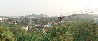
Porur is a neighbourhood of Chennai, India. It is situated in the Maduravoyal taluk of Chennai district in the southern part of the city. Since 2011, it has been a part of the Chennai Corporation and included in zone number 11.
Thiruneermalai is a neighborhood in the city of Tambaram, situated within the Chennai Metropolitan Area, Tamil Nadu, India.
Perungudi is a neighbourhood of Chennai in the state of Tamil Nadu, India. It is situated about 10 kilometres (6.2 mi) south of Adyar. It is bordered on two sides by the Old Mahabalipuram Road and the Perungudi lake. It is situated on the Old Mahabalipuram IT Expressway right in middle of an Information Technology (IT) Estate. It is between Taramani and Thoraipakkam and parallel to Kottivakkam and Palavakkam in the East Coast Road.
Bahadurganj is a town nestled in the Tarai of Himalaya and a notified area in Kishanganj district in the state of Bihar, India.
Dhilwan is a town and a nagar panchayat in Kapurthala district in the state of Punjab, India.

Injambakkam is a locality in the south of Chennai in the Indian state of Tamil Nadu. Being a part of the Walajabad block of the district, its panchayat is part of Walajabad panchayat union. Injambakkam is located along the ECR.
Kilpennathur is a Panchayat Town in Tiruvanamalai district in the Indian state of Tamil Nadu. Kilpennathur is one of the taluks of Tiruvannamalai district and an assembly constituency of Tamil Nadu. The MLA of Kilpennathur assembly constituency is DMK party Mr. K. Pichandi. Vettavalam is the most populous town panchayat in this taluk. Kilpennathur is located a 12.25 degrees latitude and 79.224 degrees longitude. Nearest towns are Avalurpet, Vettavalam, Gingee and Tiruvannamalai, and Chennai is about 177 km away.
Nallur (Nalloor) is a panchayat town in Kanniyakumari district in the Indian state of Tamil Nadu.

Olavanna is a panchayat in Kozhikode district in the Indian state of Kerala. Olavanna is the most populous panchayat in kerala. It is located 10 km from Kozhikode City. Olavanna panchayath shares the border with Kozhikode corporation and Perumanna panchayath. At first it was a large agricultural area. Today there are many small and large scale industries.Pantheerankavu is the major town in the panchayat. There are also small marketplaces such as the Olavanna Chungam, Kodinattumukku, Mathara, Palazhi, Kunnathupalam, Iringallor. The railway station is around 10 kilometres away and the nearest airport is Calicut international Airport. HiLite Mall is located in Palazhi junction.
Pallikonda is a selection grade town panchayat in Vellore district in the Indian state of Tamil Nadu. It connects with 90 villages and the town of Gudiyatham.
Peerkankaranai is a neighborhood in the city of Tambaram, situated within the Chennai Metropolitan Area, Tamil Nadu, India.
Ramapuram is a neighbourhood in the western part of Chennai, India. It is situated on the Mount-Poonamallee Road at a distance of 3 kilometres from Guindy. Ramapuram forms a part of Maduravoyal taluk, Chennai district. Ramapuram is located at an altitude of 42 m above the mean sea level with the geographical coordinates of 13.010600°N 80.193180°E.

Srinivaspur is a town located in the Kolar district of Karnataka state, India. The latitude 13.33 and longitude 78.22 are the geocoordinate of the Srinivaspur. Bengaluru is the nearby state capital for Srinivaspur town. It is located around 106 km away from Bengaluru and 80 km from BIAL. The other surrounding state capitals are Chennai 225.9 km., Pondicherry 233.2 km., Hyderabad 453.4 km.,
Thakkolam is a panchayat town in Ranipet district, Tamil Nadu, India. In Thakkolam there is a famous Siva temple, named Jalantheeswarar Temple, the main lord is Jalanadheeshwaran. It is one among 276 'Paadal Petra Sthalam. The temple is the scene for the Battle of Takkolam.
Thimiri is a panchayat town in Ranipet district in the Indian state of Tamil Nadu.The Town Panchayat was originally a religious centre with the presence of large number of temples, Mosque. The town has gained importance especially by the cultivation of paddy, Ragi. Ground nut and Sugar Cane.The Somanatha Pashana Lingeswarar Temple a Hindu temple dedicated to Lord Shiva and Kumaragiri Murugan Temple is a Hindu Temple dedicated to Lord Murugan located in Kumaragiri Hills are famous temple in Timiri. The present the area of the Town Panchayat is 6.47 km2. The town is divided into 15 election wards. Thimiri is a Town Panchayat coming under the administrative territory of Ranipet district and Arcot Taulk. This Town is located on 22 km away from Arani, 31 km at away from Vellore city and 125 km away from State capital Chennai. Thimiri is on State Highway 4 or SH4 between Arcot and Arani. This is on the main route from Arani to Chennai Highway. The State Roads connect Thimiri Town Panchayat with surrounding towns and other urban centers in the district.
Vasudevanallur is a town panchayat located 37 km from Tenkasi district in the Indian state of Tamil Nadu. It is located under the Western Ghats. This town is surrounded by farming land. Major occupation of people of this town seems farming especially paddy, sugarcane, lemon and etc., This town is being best for education among the district for both schooling and colleges.
Raya is a town and a nagar panchayat in the Mathura district of the Indian state of Uttar Pradesh. It was founded by Rai Sen, a Godar Jat. Raya formed a quarter of Tappa Raya, a chiefship in the pargana of Mahawan during the Mughal time. The descendants of Rai Sen remained in control of Tappa Raya till the revolt of 1857 during which their chief Raja Devi Singh Godar was hanged by the Britishers.
Nerkundram or Nerkunram is a census town located in Chennai City, Chennai district in the Indian state of Tamil Nadu. It falls under Maduravoyal constituency in Tiruvallur district in the Indian state of Tamil Nadu. It consists of a portion of Ambattur taluk and part of Chennai Corporation. It falls under Sriperumbudur.
Mathur is a residential area located north of Chennai, a metropolitan city in Tamil Nadu, India. Mathur is administered by the Greater Chennai Corporation and belongs to Madhavaram taluk of Chennai district.

Kovilambakkam is a southern suburb of Chennai, India. It is a village panchayat located in Tambaram taluk, Chengalpattu district in the state of Tamil Nadu, about 26 km from Chennai city center and 12 km from Tambaram. The neighbourhood spans the areas of Sunnambu Kolathur, Chinna Kovilambakkam and Periya Kovilambakkam.


