The National Severe Storms Laboratory (NSSL) is a National Oceanic and Atmospheric Administration (NOAA) weather research laboratory under the Office of Oceanic and Atmospheric Research. It is one of seven NOAA Research Laboratories (RLs).

The India Meteorological Department (IMD) is an agency of the Ministry of Earth Sciences of the Government of India. It is the principal agency responsible for meteorological observations, weather forecasting and seismology. IMD is headquartered in Delhi and operates hundreds of observation stations across India and Antarctica. Regional offices are at Chennai, Mumbai, Kolkata, Nagpur, Guwahati and New Delhi.
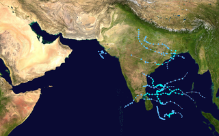
The 2005 North Indian Ocean cyclone season caused much devastation and many deaths in Southern India despite the storms’ weakness. The basin covers the Indian Ocean north of the equator as well as inland areas, sub-divided by the Arabian Sea and the Bay of Bengal. Although the season began early with two systems in January, the bulk of activity was confined from September to December. The official India Meteorological Department tracked 12 depressions in the basin, and the unofficial Joint Typhoon Warning Center (JTWC) monitored two additional storms. Three systems intensified into a cyclonic storm, which have sustained winds of at least 63 km/h (39 mph), at which point the IMD named them.

The Philippine Atmospheric, Geophysical and Astronomical Services Administration is the National Meteorological and Hydrological Services (NMHS) agency of the Philippines mandated to provide protection against natural calamities and to ensure the safety, well-being and economic security of all the people, and for the promotion of national progress by undertaking scientific and technological services in meteorology, hydrology, climatology, astronomy and other geophysical sciences. Created on December 8, 1972, by reorganizing the Weather Bureau, PAGASA now serves as one of the Scientific and Technological Services Institutes of the Department of Science and Technology.

The 2007 North Indian Ocean cyclone season was one of the most active North Indian Ocean cyclone seasons on record. The North Indian Ocean cyclone season has no official bounds, but cyclones tend to form between April and December, with peaks in May and November. These dates conventionally delimit the period of each year when most tropical cyclones form in the northern Indian Ocean.

The 2008 North Indian cyclone season was one of the most disastrous tropical cyclone seasons in modern history, causing more than 140,000 fatalities and over US$15 billion in damage. At the time, it was the costliest season in the North Indian Ocean, until it was surpassed by 2020. The season has no official bounds but cyclones tend to form between April and December. These dates conventionally delimit the period of each year when most tropical cyclones form in the northern Indian Ocean. There are two main seas in the North Indian Ocean—the Bay of Bengal, which is east of India, and the Arabian Sea, which is west of India. The official Regional Specialized Meteorological Centre in this basin is the India Meteorological Department (IMD), however the Joint Typhoon Warning Center releases unofficial advisories for military interests. An average of four to six storms form in the North Indian Ocean every season. Cyclones occurring between the meridians 45°E and 100°E are included in the season by the IMD.

The 1996 North Indian Ocean cyclone season featured several deadly tropical cyclones, with over 2,000 people killed during the year. The India Meteorological Department (IMD) – the Regional Specialized Meteorological Center for the northern Indian Ocean as recognized by the World Meteorological Organization – issued warnings for nine tropical cyclones in the region. Storms were also tracked on an unofficial basis by the American-based Joint Typhoon Warning Center, which observed one additional storm. The basin is split between the Bay of Bengal off the east coast of India and the Arabian Sea off the west coast. During the year, the activity was affected by the monsoon season, with most storms forming in June or after October.

India is a country in the north of Indian Ocean that is the most vulnerable to getting hit by tropical cyclones in the basin, from the east or from the west. On average, 2–3 tropical cyclones make landfall in India each year, with about one being a severe tropical cyclone or greater.

Regional Meteorological Centre, Chennai is one of the six regional meteorological centres (RMCs) of the India Meteorological Department (IMD) and is responsible for the weather-related activities of the southern Indian peninsula comprising the states of Andhra Pradesh, Telangana, Karnataka, Kerala, Tamil Nadu and the union territories of Andaman and Nicobar, Lakshadweep Islands and Puducherry. The other regional centres are located at Kolkata, Guwahati, Mumbai, Nagpur and New Delhi.

The 2002 West Bengal cyclone was a deadly tropical cyclone that affected India and Bangladesh in November 2002. The sixth tropical cyclone and fourth cyclonic storm of the 2002 North Indian Ocean cyclone season, it developed in the Bay of Bengal northeast of Sri Lanka on November 10, as a tropical depression. After tracking northeast, the system strengthened into a cyclonic storm on November 11, as maximum sustained winds exceeded 65 km/h (40 mph). On November 12, it further intensified into a severe cyclonic storm. Later that day, the storm made landfall on Sagar Island in West Bengal with winds of 100 km/h (60 mph). After moving inland, it rapidly weakened and dissipated over Bangladesh on November 12.

The 2013 North Indian Ocean cyclone season was an event in the annual cycle of tropical cyclone formation, in which tropical cyclones formed in the North Indian Ocean and Arabian Sea. The season had no official bounds, but cyclones typically formed between May and December, with the peak from October to November. These dates conventionally delimit the period of each year when most tropical cyclones form in the northern Indian Ocean.

The Climate of Tamil Nadu, India is generally tropical and features fairly hot temperatures over the year except during the monsoon seasons. The city of Chennai lies on the thermal equator, which means Chennai and Tamil Nadu does not have that much temperature variation.

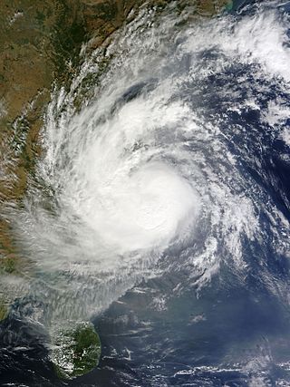
Cyclonic Storm Nilam was the deadliest tropical cyclone to directly affect South India since Cyclone Jal in 2010. Originating from an area of low pressure over the Bay of Bengal on October 28, 2012, the system began as a weak depression 550 km (340 mi) northeast of Trincomalee, Sri Lanka. Over the following few days, the depression gradually intensified into a deep depression, and subsequently a cyclonic storm by October 30. It made landfall near Mahabalipuram on October 31 as a strong cyclonic storm with peak winds of 85 km/h (55 mph). In Chennai's Marina Beach, strong winds pushed piles of sand ashore and seawater reached nearly a 100 m (330 ft) inland. Schools and colleges in the city remained closed for more than three days.

The 2016 North Indian Ocean cyclone season was an event in the annual cycle of tropical cyclone formation. It was the deadliest season since 2010, killing more than 400 people. The season was an average one, seeing four named storms, with one further intensifying into a very severe cyclonic storm. The first named storm, Roanu, developed on 19 May while the season's last named storm, Vardah, dissipated on 18 December. The North Indian Ocean cyclone season has no official bounds, but cyclones tend to form between April and December, with the two peaks in May and November. These dates conventionally delimit the period of each year when most tropical cyclones form in the northern Indian Ocean.

Cyclonic Storm Roanu was a relatively weak tropical cyclone that caused severe flooding in Sri Lanka and Bangladesh during May 2016. It is the first tropical cyclone of the annual cyclone season. Roanu originated from a low-pressure area that formed south of Sri Lanka, which gradually drifted north and intensified into a cyclonic storm on 19 May. However, wind shear and land interaction caused it to weaken slightly, before reintensifying as it accelerated towards the coast of Bangladesh.

The 2017 North Indian Ocean cyclone season was a below average yet deadly season in the annual cycle of tropical cyclone formation. This season produced only three named storms, of which one only intensified into a very severe cyclonic storm. The North Indian Ocean cyclone season has no official bounds but cyclones tend to form between April and December with the two peaks in May and November. These dates conventionally delimit the period of each year when most tropical cyclones form in the northern Indian Ocean. The season began with the formation Cyclone Maarutha on April 15 and ended with the dissipation of a deep depression on December 9.
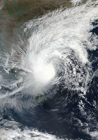
Very Severe Cyclonic Storm Vardah was the fourth cyclonic storm, as well as the most intense tropical cyclone of the 2016 North Indian Ocean cyclone season. The remnants of the system later regenerated into Depression ARB 02 in the Arabian Sea. The system struck the Andaman and Nicobar Islands, as well as South India, before later affecting Somalia.
Severe Cyclonic Storm Phethai was a tropical cyclone which affected some portions of Sri Lanka and India during December 2018. The fourteenth depression, ninth deep depression, seventh cyclonic storm, and fifth severe cyclonic storm of the 2018 North Indian Ocean cyclone season, Phethai developed from an area of low pressure that formed over the Bay of Bengal on December 13. Having forecasted not to develop significantly, the depression then strengthened to a deep depression later that day before becoming a cyclonic storm on December 15. Phethai further intensified and peaked to a severe cyclonic storm, the following day. The system then steadily weakened due to land interaction and increasing wind shear, before making landfall as a disorganized system over Andhra Pradesh on December 17. It degenerated to an area of low-pressure inland later that day.
The 2021 South India floods are a series of floods associated with Depression BOB 05 and a low pressure system that caused widespread disruption across the Indian states of Tamil Nadu, Andhra Pradesh, and the nearby Sri Lanka. The rainfall started on 1 November in Tamil Nadu. The flooding was caused by extremely heavy downpours from BOB 05, killing at least 41 people across India and Sri Lanka.

