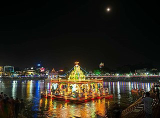
Mylapore is a neighbourhood in the central part of the city of Chennai, India. It is one of the oldest residential parts of the city. It is also called Tirumayilai. The locality is claimed to be the birthplace of the celebrated Tamil philosopher Valluvar, and the Hindu saint and philosopher, Peyalvar.
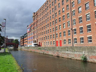
A cotton mill is a building that houses spinning or weaving machinery for the production of yarn or cloth from cotton, an important product during the Industrial Revolution in the development of the factory system.

Avadi is a suburb of Chennai within Chennai Metropolitan Area limit, located in the Thiruvallur district of Tamil Nadu, India. It is a municipal corporation west of Chennai, about 22 kilometres (14 mi) from Chennai Central Railway Station. It is surrounded by major defence establishments and is home to various universities and engineering colleges. The city is served by Avadi Railway Station of the Chennai Suburban Railway. As of 2011, Avadi had a population of 345,996, which is 10th most populous place in Tamil Nadu. It is home to the Heavy Vehicles Factory (HVF), Ordnance Factory Board (ODF) which houses Engine Factory and Combat Vehicles Research and Development Establishment (CVRDE). The lake in Avadi was known as Paaleripattu, which is now found only in very old land documents.

Thyagaraya Nagar, commonly known as T. Nagar, is a very affluent commercial and residential neighbourhood in Chennai, Tamil Nadu, India. It is surrounded by Nungambakkam in the North, Teynampet in the East, Nandanam in the South-East, C.I.T. Nagar in the South and West Mambalam and Kodambakkam in the West. The stretch between Duraiswamy Road and T. Nagar Bus Stand has some of the costliest real estates in Chennai. It was constructed between 1923 and 1925 by the Madras Presidency government of the Raja of Panagal as a part of town planning activities initiated according to the Madras Town Planning Act of 1920. The town was named after P. Thyagaraya Chetty. The streets, parks and localities in the new neighbourhood were named after important officials in the provincial government.

Kanchipuram also known as Conjeevaram, is a city in the Indian state of Tamil Nadu in the Tondaimandalam region, 72 km (45 mi) from Chennai – the capital of Tamil Nadu. Known as the City of Thousand Temples, Kanchipuram is known for its temple architectures, 1000-pillared halls, huge temple towers and silk sarees. Kanchipuram serves as one of the most important tourist destinations in India. Kanchipuram has become a centre of attraction to the foreign tourists as well. The city covers an area of 36.14 km2 (13.95 sq mi) and an estimated population of more than 3,00,000 in 2021. It is the administrative headquarters of Kanchipuram District. Kanchipuram is well-connected by road and rail.

Triplicane, known in the vernacular as Thiruvallikeni, is one of the oldest neighbourhoods of Chennai, India. It is situated on the Bay of Bengal coast and about 0.6 km (0.37 mi) from Fort St George. The average elevation of the neighbourhood is 14 metres above sea level.

Velachery is a commercial and residential area in south Chennai, and is the largest commercial centre in south Chennai. It is surrounded by Guindy in the north, IIT Madras in the north-east, Taramani in the east, Perungudi in the south-east, Pallikaranai Wetland in the south, Madipakkam in the south and south-west, Adambakkam in the west and north-west. The growth of the neighbourhood during the last decade can be cited due to the growth of the IT sector in south Chennai. It acts as an important hub connecting the rapidly growing business-class information technology corridor popularly called the OMR; the more mature and very well-connected GST road and the central business districts of the city, which has more relevance to the history of Chennai. Velachery as a whole draws a perfect balance between old and new Chennai and is a phenomenon in terms of growth and development.

Saidapet, also known as Saidai, is a neighbourhood in Chennai, India, situated in the northern banks of the Adyar River and serves as an entry point to Central Chennai. It is surrounded by West Mambalam in the North, C.I.T Nagar in the North-East, Nandanam in the East, Guindy in the South, Jafferkhanpet and Ashok Nagar in the North-West. The Saidapet Court, the only other court of judicature in Chennai city apart from the Madras High Court, and the Saidapet bus depot are located here. Prior to its incorporation in Madras city, Saidapet functioned as the administrative headquarters of Chingleput district. The neighbourhood is served by Saidapet railway station of the Chennai Suburban Railway Network.

Chennai architecture is a confluence of many architectural styles. From ancient Tamil temples built by the Pallavas, to the Indo-Saracenic style of the colonial era, to 20th-century steel and chrome of skyscrapers. Chennai has a colonial core in the port area, surrounded by progressively newer areas as one travels away from the port, punctuated with old temples, churches and mosques.

Karur District is one of the 38 districts in the Indian state of Tamil Nadu. The main town in Karur District is the city of Karur, which is also the district headquarters. The district has a population of 1,064,493 with a sex-ratio of 1,015 females for every 1,000 males, according to 2011 census.

Marundeeswarar Temple is a temple dedicated to Hindu deity Shiva, located in Thiruvanmiyur, Chennai adjacent to the beach of Bay of Bengal. It is one of the 275 Paadal Petra Sthalams where two of the most revered Nayanars, Appar and Tirugnana Sambandar, have glorified the temple with their verses during the 7th–8th century CE. The temple has been widely expanded by Chola kings during the 11th century CE. The temple has two seven-tiered gateway towers, a huge tank, with the overall temple area covering 1 acre. The Marundeeswarar temple has been a place of curative worship for people with diseases.

George Town is a neighbourhood in Chennai, Tamil Nadu, India. It is near the Fort Saint George, Chennai. It is also known as Muthialpet and Parry's corner. It is an historical area of Chennai city from where its expansion began in the 1640s. It extends from the Bay of Bengal in the east to Park town on the west. The Fort St. George is on the south, to Royapuram in the north. The Fort St. George houses the Tamil Nadu Legislative Assembly and the Secretariat. The High court of Tamil Nadu at Chennai, Dr. Ambedkar Law College, Stanley Medical College and Hospital are located here.
Tamil Nadu has the largest tourism industry in India with a percentage share of 21.31% and 21.86% of domestic and foreign tourist visits in the country. According to the 2020 Ministry of Tourism report, the number of domestic arrivals was at 494.8 million making the state the second most popular tourist destination in the country, and foreign arrivals numbered 6.86 million, the highest in the country, making it the most popular state for tourism in the country.
Mallikesvarar Temple or Mallikarjunar Temple is a Hindu temple situated in the neighbourhood of George Town in the city of Chennai, India. It is one of the first Hindu temples to be constructed in the British settlement of Madrasapatnam. There is the nearby Chenna kesava perumal Temple. They are twin temples. This is also called Chenna Malleeswarar temple. Chenna pattanam may be named after this deities. The word 'chenni' in Tamil means face, and the temple was regarded as the face of the city.

ISKCON Temple Chennai, also known as the Sri Sri Radha Krishna Mandir, is a Gaudiya Vaishnavism temple in Chennai, India. The temple is dedicated to Hindu god Radha and Krishna. It was formally inaugurated on 26 April 2012.

Peravallur is a developed residential area, located on the north - western corner of Madras, a metropolitan city in Tamil Nadu state, India. Out of 1018 places to be renamed by the government of Tamil Nadu, Peravallur is the one to be renamed as "Peravalloor". CMDA is the town planning agency for Peravallur. Official language is Tamil; Postal pincode is 600082; Greater Chennai Corporation is the Civic body. A police station viz., K - 5 Peravallur Police Station for this neighborhood is built a year ago with ample space, at the junction of Venkatesan Salai and Siva Elango Salai in Jawahar Nagar near Perambur.
Otteri, is a developed residential area in Central Chennai, a metropolitan city in Tamil Nadu, India. Otteri is a part of Purasaiwakkam but is too distinct to be called hence locals simply refer it as Otteri.
Pattalam, is a developed residential area in Central Chennai, a metropolitan city in Tamil Nadu, India.


