
Adambakkam is a neighbourhood of Chennai, India. It is primarily a residential locality situated in South Chennai. Adambakkam area comes under Velachery taluk and Alandur taluk, Chennai District of Chennai Corporation. Adambakkam is surrounded by areas namely, Alandur in the North-West, Nanganallur in the West, Madipakkam in the South, Velachery in the East and Guindy in the North. Earlier, one part of Adambakkam was under the direct governance of Chennai Corporation. From October 2011 onwards, the entire area was merged with the Chennai Corporation. Upon completion of the MRTS extension line, the neighbourhood will be served by Adambakkam railway station. Its Proximity to commercial localities like Velachery, accessible railway stations, Metro Stations and road transport routes makes Adambakkam an ideal choice of location to live.

Koyambedu is a neighbourhood in Chennai, India. Situated in the western part of Chennai city, the Koyambedu area has become a major hub of activity in Chennai after the inauguration of the Koyambedu market in 1996 and the Chennai Mofussil Bus Terminus (CMBT) in 2002. The area is active round the clock owing to the movement of people and goods through the day, with uninterrupted transport facilities such as long-route buses, autos, share autos, vegetable goods carriers and so forth.

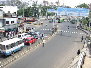
Thyagaraya Nagar, commonly known as T. Nagar, and historically known as East Mambalam, is a very affluent commercial and residential neighbourhood in Chennai, Tamil Nadu, India. It is surrounded by Nungambakkam in the North, Teynampet in the East, Nandanam in the South-East, C.I.T. Nagar in the South and West Mambalam and Kodambakkam in the West. The stretch between Duraiswamy Road and T. Nagar Bus Stand has some of the costliest real estates in Chennai. It was constructed between 1923 and 1925 by the Madras Presidency government of the Raja of Panagal as a part of town planning activities initiated according to the Madras Town Planning Act of 1920. The town was named after P. Thyagaraya Chetty. The streets, parks and localities in the new neighbourhood were named after important officials in the provincial government.

Anna Nagar, is a neighbourhood in the metropolitan city of Chennai, India. Named after former Chief Minister of Tamil Nadu C. N. Annadurai, it is located in the north-western part of Chennai and forms a part of the Aminjikarai taluk and the Anna Nagar Zone. It is one of the prime residential areas in Chennai and is home to several prominent doctors, lawyers and politicians. Real estate prices are among the highest in the city. A recent addition to the area is VR Chennai Mall, located near Shanthi Colony and Thirumangalam junction.
Virugambakkam is a residential neighbourhood of Chennai, Tamil Nadu, India. It is an important residential area of and is famous for its schools, market, residential colonies and residences of film artists. Virugambakkam had some of Chennai's oldest film studios.

Saidapet, also known as Saidai, is a neighbourhood in Chennai, India, situated in the northern banks of the Adyar River and serves as an entry point to Central Chennai. It is surrounded by West Mambalam in the North, C.I.T Nagar in the North-East, Nandanam in the East, Guindy in the South, Jafferkhanpet and Ashok Nagar in the North-West. The Saidapet Court, the only other court of judicature in Chennai city apart from the Madras High Court, and the Saidapet bus depot are located here. Prior to its incorporation in Madras city, Saidapet functioned as the administrative headquarters of Chingleput district. The neighbourhood is served by Saidapet railway station of the Chennai Suburban Railway Network.
Nanganallur or Nangainallur is one of the southern neighborhoods of Chennai, India. Since September 2011, it has become a part of Chennai Corporation. It is a residential area close to the Chennai International Airport.

Poonamallee is a town and suburb of Chennai, India under the Chennai Metropolitan Area. It was historically called Pushpagirimangalam, later renamed in Tamil as Poovirundhavalli, and now colloquially called as Poondhamalli. It is the headquarters of the Poonamallee taluk of the Tiruvallur district in the Indian state of Tamil Nadu. The nearest Railway station is at Avadi. It acts as the gateway to the city from its western side. It is a town with rich cultural heritage and also a fast-growing areas in the city. As of 2011, the town had a population of 57,224. There are plans to merge the areas under Poonamallee Municipality with Avadi Municipal Corporation.
Pammal is a southern suburb in Chennai, Tamil Nadu, India.
Arumbakkam is a residential locality in Chennai.
Minjur is a suburb located in the northern outskirts of Chennai, India. It is located in Thiruvallur district in the Indian state of Tamil Nadu. Minjur is called 'Vada Kanchi' meaning North Kanchipuram. The locality has two famous temples for Shiva and Vishnu, similar to Kanchipuram. The neighbourhood is served by Minjur railway station of the Chennai Suburban Railway Network.
Mugalivakkam is a neighbourhood of Chennai. It is located in Sriperumbudur taluk of Kanchipuram district, in Tamil Nadu. It is situated 16 km south-west of Chennai on the Mount-Poonamallee Road. It is bounded by Porur on the North Meenambakkam and Manapakkam on the South and South East, Madhanandhapuram and Gerugambakkam on the South West and Ramapuram on the North East directions. The nearest railway station is at Guindy which is about 6 kilometres away. Porur junction is around 2 km away and Kathipara Junction is around 5 km away.
West Mambalam is a residential and commercial area in Chennai, India. It is known for its shops, bazaars and Hindu temples. It is bounded by Kodambakkam to the north and Saidapet to the south. T. Nagar and Nandanam stretch all along its eastern frontiers while Ashok Nagar lies to its west. The Ayodhya Mandapam is an important landmark.
Choolaimedu is a large residential and commercial locality in Chennai, Tamil Nadu, India. It borders Kodambakkam, Vadapalani, M.M.D.A. Colony, Aminjikarai, Mahalingapuram and Nungambakkam. Previously a part of Puliyur village, Kodambakkam, Choolaimedu has now become a hub for commercial interests and connects two of the busiest routes in Chennai, namely Arcot Road and Nelson Manickam Road.

Anna Salai, formerly known as St. Thomas Mount Road or simply Mount Road, is an arterial road in Chennai, India. It starts at the Cooum Creek, south of Fort St George, leading in a south-westerly direction towards St. Thomas Mount, and ends at the Kathipara Junction in Guindy. Beyond the Kathipara Junction, a branch road arises traversing westwards to Poonamallee to form the Mount-Poonamallee Road while the main branch continuing southwards to Chennai Airport, Tambaram and beyond to form Grand Southern Trunk Road. Anna Salai, which is more than 400 years old, is acknowledged as the most important road in Chennai city. The head offices of many commercial enterprises and public buildings are located along Anna Salai. It is the second longest road in Chennai, after EVR Periyar Salai.
Madhavaram Milk Colony is a neighbourhood in northern Chennai, a metropolitan city in Chennai district in the Indian state of Tamil Nadu.

Ampa Skywalk is a shopping mall in Chennai, India. With three floors of retail space, it has outlets for major clothing and apparel brands, a seven-screen multiplex, a games zone and a food court.
EVR Periyar Salai (EVR High Road), earlier known as Poonamallee High Road(NH 48) and originally the Grand Western Trunk Road, is an arterial road in Chennai, India. It is the longest road in Chennai. Running from east to west, the 14-kilometre (8.7 mi) road starts at Muthuswamy Bridge near Madras Medical College at Park Town and ends near Maduravoyal Junction via Kilpauk, Aminjikarai, Anna Nagar Arch, Arumbakkam, Koyambedu. It further continues west towards Poonamallee and traverses the towns of Sriperumbudur, Walajapet, and Ranipet.

Peravallur is a developed residential area, located on the north - western corner of Madras, a metropolitan city in Tamil Nadu state, India. Out of 1018 places to be renamed by the government of Tamil Nadu, Peravallur is the one to be renamed as "Peravalloor". CMDA is the town planning agency for Peravallur. Official language is Tamil; Postal pincode is 600082; Greater Chennai Corporation is the Civic body. A police station viz., K - 5 Peravallur Police Station for this neighborhood is built a year ago with ample space, at the junction of Venkatesan Salai and Siva Elango Salai in Jawahar Nagar near Perambur.

Agaram is a neighbourhood of Perambur and a developed residential area in North Chennai, a metropolitan city in Tamil Nadu, India.


