Timeline of town creation in New York's Capital District

Last updated

Opening paragraph of the Dongan Charter creating the city of Albany, New York, the oldest municipality in New York's Capital District Charterdoc.jpg
Opening paragraph of the Dongan Charter creating the city of Albany, New York, the oldest municipality in New York's Capital District

The towns and cities of New York's Capital District were created by the U.S. state of New York as municipalities in order to give residents more direct say over local government. [1] The Capital District is an 11 county area, which consists of the counties of Albany, Schenectady, Rensselaer, Saratoga, Schoharie, Warren, Washington, Columbia, Montgomery, Fulton, and Greene. [2] New York experimented with different types of municipalities before settling upon the current format of towns and cities occupying all the land in a county. [3] Districts were created for Albany and Tryon counties in 1772; [4] all were transformed into towns (or divided into multiple towns) in 1788 when all of the state of New York was divided into towns. [1] Two years before that, in 1786, all of what Washington County encompassed at that time was divided into townships with the same legal status, abilities, and responsibilities as districts [5] with their status as towns confirmed in 1788. [1] Some other forms of government in earlier years included land patents with some municipal rights and boroughs. The following timelines show the creation of the current towns from their predecessors stretching back to the earliest municipal entity over the area. The timelines only represent from which town(s) a particular town was created from and does not represent annexations of territory to and from towns that already existed. All municipalities are towns unless otherwise noted as patent, township, borough, district, or city. Unless otherwise sourced with a footnote all dates of incorporation represent those stated in the 1860 Gazetteer of the State of New York by John H. French.

Contents

Albany and Rensselaer counties, with Niskayuna (Schenectady County)

Beverwyck
village
1652[0]
(Albany
in 1664)
Albany
city
1686[A]
West
Manor
district
1779-
1788[A]
Watervliet
1788 [1]
-1896[A]
Rensselaer-
ville

1790[A]
Berne
1795[A]
Knox
1822[A]
Westerlo
1815[A]
Coeymans
1791[A]
Bethlehem
1793[A]
New
Scotland

1832[A]
Guilderland
1803[A]
Manor [A]
district
1772-
1779
Colonie [A]
1808-1815
Niskayuna
1809[B]
Cohoes [A]
city 1869 [6]
Colonie
1895 [7] [A]
Green Island
1896 [8] [A]
North
Greenbush

1855[D]
Watervliet
city
1896 [8] [A]
Clinton
1855[D]
(East
Greenbush

in 1858)
Greenbush
1795-
1897[D]
Rensselaer
city
1897 [9] [D]
East
Manor
district
1779-
1784[A]
Rensselaer-
wyck
district[A]
1784-1788
Rensselaer-
wyck[C]
1788 [1] -
1795
Schodack
1795[D]
Sand
Lake
[D]
1812
Brunswick
1807[D]
Troy
1791-
1816[D]
Troy
city
1816[D]
Poesten-
kill

1848[D]
Lansing-
burgh

1807-1901[D]
Stephentown
district
1784-1788[A]
Stephentown
1788 [1] [C]
Petersburgh
1791[D]
Grafton
1807[D]
Berlin
1806[D]
Philips-
town
1806[D]
(Nassau
in 1808)
Schagh-
ticoke
district
1772-
1788[A]
Schagh-
ticoke

1788 [1] [C]
Pittstown
1788 [1] [a] [C]
Hoosick
district
1772-
1788[A]
Hoosick
1788 [1] [C]

Notes

[0]= A part of New Netherland, a Dutch territory, until 1664, thereafter part of the English colony of New York,
and within Albany County from its formation in 1683.
[A] = A part of Albany County.
[B] = A part of Schenectady County when formed from Albany County in 1809.
[C] = A part of Albany County until 1791 when Rensselaer County was formed.
[D] = A part of Rensselaer County.

Schoharie and Greene counties, with Duanesburgh (Schenectady County)

Hurley
township[9]
1708-1788
Woodstock
township [10]
1787-1788[9]
Woodstock
1788 [1] [9]
Windham
1798[10]
Greenland
1813[F]
(Hunter in 1814)
Jewett
1849[F]
New Goshen[F]
January 17, 1813
(Lexington
in March 19, 1813)
Halcott
1851[F]
Prattsville
1833[F]
Ashland
1848[F]
Great Imboght
District[A]
1772-1788
Catskill 1788[2]
Athens 1815[F]
Coxsackie
District
1772-1788[A]
Coxsackie 1788[C]
Canton 1803[F]
(Cairo 1808)
New Baltimore
1811[F]
Freehold 1790[C]
change to
Durham 1805
Greenfield 1803[F]
(Freehold in 1808)
(Greenville 1809)
Duanesburgh
patent[A]
1765 [11] -1772
Duanesburg
1789 [12] [D]
Conesville
1836[8]
United Districts
of Duanesburgh
and Schoharie
1772 [4] -1788[A]
Schoharie
1788 [1] [E]
Bristol 1797[G]
change to
Broome 1808
Gilboa 1848[G]
Schoharie[A]
patent
1714 [13] -1772
Blenheim 1797[G] Jefferson
1803[G]
Richmondville
1845[G]
Summit 1819[G]
Cobleskill 1797[G]
Carlisle 1807[G]
Sharon 1797[G] Seward 1840[G]
Middletown 1797
Middleburgh 1801[G]
Fulton 1828[G]
Wright 1846[G]
Esperance 1846[G]

Notes

[A] = A part of Albany County.


[2] = A part of Albany County until 1798, then part of Ulster County until 1800 when Greene County was formed.

[C] = A part of Albany County until 1800 when Greene County was formed.
[D] = A part of Albany County, until 1809 when Schenectady County was formed.
[E] = A part of Albany County until 1797 when Schoharie County was formed.
[F] = A part of Greene County
[G] = A part of Schoharie County
[H] = Schoharie County annexed a portion of the town of Durham (Greene County) in 1836,
that portion was joined with a part of the town of Broome to become Conesville.


[9] = A part of Ulster County.
[10] = A part of Ulster County until 1800 when Greene County was formed.

Schenectady County, except Niskayuna and Duanesburgh

Schenectady City Hall SchenectadyCityHallRear.jpg
Schenectady City Hall
Schenectady patent 1684-1765[A]
Schenectady borough 1765-1772[A]
Schenectady district 1772-1788[A]
Schenectady town 1788-1798[A]
Princetown 1798[B] Schenectady city 1798[B]
Glenville 1820[C] Rotterdam 1820[C]

Notes

[A] = A part of Albany County.
[B] = A part of Albany County, until 1809 when Schenectady County was formed.
[C] = A part of Schenectady County.

Saratoga County, and Easton (Washington County)

Charlton
1792[C]
Galway
1792[C]
Providence
1796[C]
Northfield
1801
(Edinburgh
in 1808)[C]
Corinth
1818[C]
Ballstown
district
1775-
1788[A]
Ballston
1788[B]
Milton
1792[C]
Saratoga
district
1772-
1788[A]
Greenfield
1793[C]
Concord 1819
(Day in 1827)[C]
Hadley
1801[C]
Saratoga
1788[B]
Northumberland
1798[C]
Moreau
1805[C]
Wilton
1818[C]
Saratoga
Springs
town 1819-
1915[C]
Saratoga
Springs

city
1915 [14] [C]
Easton
1789[D]
Stillwater
1788[B]
Malta
1802[C]
Halfmoon
district
1772-
1788[A]
Mechanicville
city 1915 [15] [C]
Halfmoon
1788[B]
Waterford
1816[C]
Clifton 1828
(Clifton Park
in 1829)[C]

Notes

[A] = A part of Albany County.
[B] = A part of Albany County, until 1791 when Saratoga County was formed.
[C] = A part of Saratoga County.
[D]= A part of Albany County, until 1791 when annexed by Washington County

Washington County, except Easton

Jackson
1815[D]
Cambridge
patent[A]
1761-1788
Cambridge
1788[C]
White Creek
1815[D]
Kingsbury
patent[B]
1762-1786
Kingsbury[D]
township
1786-1788
Kingsbury
1788[D]
Argyle
patent[B]
1764-1786
Argyle[D]
township
1786-1788
Argyle
1788[D]
Greenwich
1803[D]
Salem[B]
patent
1764-1786
Salem[D]
township
1786-1788
Salem [D]
1788
Fort Edward
1818[D]
Skenesborough
patent[B]
1765-1786
Whitehall[D]
township
1786-1788
Whitehall
1788[D]
Granville[D]
township
1786-1788
Granville
1788[D]
Hampton[D]
township
1786-1788
Hampton
1788[D]
Hebron[D]
township
1786-1788
Hebron
1788[D]
Westfield[D]
township
1786-1788
Westfield
1788[D]
(Fort Ann
in 1808)
Hartford
1793[D]
Putnam
1806[D]
South Bay[D]
March 15, 1822
(Dresden in
April 17, 1822)

Notes

[A] = A part of Albany County.
[B]= A part of Albany County until 1772 when Charlotte County was formed (name changed to Washington County in 1778).
[D]= A part of Albany County, until 1791 when annexed by Washington County
[D]= A part of Washington County.

Warren County

Caldwell
1810[3]
(Lake George
in 1963 [16] )
Chester
1799[3]
Bolton
1799[3]
Rochester
1807[3](Hague
in 1808)
Horicon
1838[4]
Queensbury
patent[A]
1762-1786
Queensbury
township[B]
1786 [5] -1788
Queensbury
1788[3] [1]
Thurman[B] [17]
1792-1813
Johnsburg
1805[3]
Fairfield
1792[3]
(Luzerne
in 1808
Lake Luzerne
in 1963 [16] )
Athol[4]
1813-1852
Thurman
1852[4]
Glens Falls
city 1908[4]
Warrensburg
1813[4]
Stony Creek
1852[4]

Notes

[A]= A part of Albany County until 1772 when Charlotte County was formed (name changed to Washington County in 1778).
[B]= A part of Washington County.


[3] = A part of Washington County until 1813 when Warren County was formed.
[4] = A part of Warren County.

Columbia County

Hillsdale
District[A]
1782-1788
Hillsdale
1788[B]
Hudson
city[A]
1785
Greenport
1837[B]
Claverack
District[A]
1772-1788
Claverack
1788[B]
(1)(1)
Stuyvesant
1823[B]
Stockport
1833[B]
Kinderhook
District[A]
1772-1788
Kinderhook
1788[B]
Ghent
1818[B]
Chatham
1795[B]
Austerlitz
1818[2]
Kings
District[A]
1772-1788
Canaan
1788[B]
New Lebanon
1818[B]
German Camp [18]
(East Camp)
District[A]
1775-1788
Germantown
1788[B]
Clermont
1788[B]
Gallatin 1803
(Ancram 1814)[B]
Gallatin
1830[B]
Manor
of
Livingston

District[A]
1772-1788
Livingston
1788[B]
Granger 1803[B]
(Taghkanic 1814)
Copake
1824[B]

Notes

[A] = A part of Albany County until 1786 when Columbia County was formed.
[B]= A part of Columbia County.

Fulton, Montgomery, and Hamilton counties, with part of Herkimer County

Salisbury
1797
Oppenheim
1808
St. Johnsville
1838
Manheim
1817
Stone
Arabia
1772-
1788
(Palatine
in 1773)
Palatine
1788
Ephratah
1827
Canajoharie
district
1772-1788
Canajoharie
1788
Minden
1798
Danube
1812
Stark
1828
Bleecker
1831
Caroga
1842
Root
1823
Gloversville
1840
Johnstown
1895
Mohawk
district
1772-
1788
Mohawk
1788-
1793
Charleston
1793
Glen
1823
Johnstown
1793
Florida
1793
Mohawk
1837
Lake Pleasant
1812
Arietta
1836
Long Lake
1837
Morehouse
1835
Inlet
1901
Caughnawaga
district
1780-1788
Caughnawaga
1788-1793
Mayfield
1793
Wells
1805
Indian Lake
1858
Broadalbin
1793
Northampton
1799
Hope
1818
Benson
1860
Amsterdam
1793
Perth
1838
Gilman
1839-1860
Amsterdam
city
1885

See also

Notes

Related Research Articles

<span class="mw-page-title-main">Albany County, New York</span> County in New York, United States

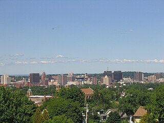
Albany County is a county in the state of New York, United States. Its northern border is formed by the Mohawk River, at its confluence with the Hudson River, which is to the east. As of the 2020 United States Census, the population was 314,848. The county seat and largest city is Albany, which is also the state capital of New York. As originally established by the English government in the colonial era, Albany County had an indefinite amount of land, but has had an area of 530 square miles (1,400 km2) since March 3, 1888. The county is named for the Duke of York and of Albany, who became James II of England.

<span class="mw-page-title-main">Schenectady County, New York</span> County in New York, United States

Schenectady County is a county in the U.S. state of New York. As of the 2020 census, the population was 158,061. The county seat is Schenectady. The name is from a Mohawk language word meaning "on the other side of the pine lands," a term that originally applied to Albany.

<span class="mw-page-title-main">Schoharie County, New York</span> County in New York, United States

Schoharie County is a county in the U.S. state of New York. As of the 2020 census, the population was 29,714, making it the state's fifth-least populous county. The county seat is Schoharie. "Schoharie" comes from a Mohawk word meaning "floating driftwood." Schoharie County is part of the Albany-Schenectady-Troy, NY Metropolitan Statistical Area.

<span class="mw-page-title-main">Brunswick, New York</span> Town in New York, United States

Brunswick is a town in Rensselaer County, New York, United States. The municipality was originally settled in the early 18th century. During its history, it had been part of Albany County, Rensselaerswyck, and Troy, before its incorporation in 1807. It is bordered on the west by the city of Troy; on the north by Schaghticoke and Pittstown; on the east by Grafton; and on the south by Poestenkill and North Greenbush. The population was 11,941 at the 2010 census. The source of the town's name is not certain, though some claim it comes from the source of its first inhabitants from the province of Brunswick-Lüneburg in Germany.

<span class="mw-page-title-main">Duanesburg, New York</span> Town in New York, United States

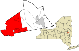
Duanesburg is a town in Schenectady County, New York, United States. The population was 6,122 at the 2010 census. Duanesburg is named for James Duane, who held most of it as an original land grant. The town is in the western part of the county.

<span class="mw-page-title-main">Capital District (New York)</span> Region in New York, United States

The Capital District, also known as the Capital Region, is the metropolitan area surrounding Albany, the capital of the U.S. state of New York. The Capital District was first settled by the Dutch in the early 17th century and came under English control in 1664. Albany has been the permanent capital of the state of New York since 1797. The Capital District is notable for many historical events that predate the independence of the United States, including the Albany Plan of Union and the Battles of Saratoga.

<span class="mw-page-title-main">New York's congressional districts</span> U.S. House districts in the state of New York

The U.S. state of New York currently comprises 26 congressional districts. Each district elects one member of the United States House of Representatives who sits on its behalf. The state was redistricted in 2022, following the 2020 U.S. census. It lost one seat in Congress.

<span class="mw-page-title-main">New York State Route 7</span> State highway in New York, United States

New York State Route 7 (NY 7) is a 180.30-mile-long (290.16 km) state highway in New York in the United States. The highway runs from Pennsylvania Route 29 (PA 29) at the Pennsylvania state line south of Binghamton in Broome County, New York, to Vermont Route 9 (VT 9) at the Vermont state line east of Hoosick in Rensselaer County. Most of the road runs along the Susquehanna Valley, closely paralleling Interstate 88 (I-88) throughout that road's length. Portions of the highway route near the cities of Binghamton, Schenectady, and Troy date back to the early 19th century.

Watervliet was a town that at its height encompassed most of present-day Albany County and most of the current town of Niskayuna in neighboring Schenectady County, in the state of New York, United States. Just prior to its dissolution, the town encompassed the current towns of Colonie and Green Island and the city of Watervliet.

The towns and cities of Downstate New York were created by the U.S. state of New York as municipalities in order to give residents more direct say over local government. Present-day Westchester, Bronx, New York, Richmond, Kings, Queens, Nassau, and Suffolk counties were part of York Shire from 1664-August 1673 and again from February 1674 until 1683 at which point the Province of New York was divided into counties. From August 1673 to February 1674 New York was under Dutch control and English political units were suspended, then restored under English rule. York Shire was divided into three divisions called ridings, the East, West, and North ridings. In 1683 the colony of New York eliminated shires and ridings in favor of counties, the East Riding becoming Suffolk County, West Riding the counties of Richmond and Kings, while the North Riding became the counties of Westchester, New York, and Queens.

<span class="mw-page-title-main">Timeline of town creation in the Hudson Valley</span>

The towns and cities of the Hudson Valley were created by the U.S. state of New York as municipalities, in order to perform the services of local government. In 1683, prior to the creation of modern towns, the Province of New York was divided into twelve counties for administrative purposes by the Colonial Governor of New York. In the Hudson Valley, these divisions included Dutchess, Orange, and Ulster counties. Dutchess and Orange remained unorganized until 1713, with Dutchess administered from Ulster; Orange would be administered from New York County. Future counties would be formed and towns exchanged over time, with Rockland County split from Orange in 1799, at which time the southern towns of Ulster were transferred to Orange as compensation for the loss; and Putnam County from Dutchess in 1812, these county's towns can trace their origins to towns and precincts that were formed in their parent counties. Another change that occurred was the transfer of Dutchess County's northern section, the Livingston Manor, to Columbia County. Greene County was formed in 1800 by the combination of the southernmost towns of Albany County with the northernmost towns of Ulster. The history of the towns of Greene and Columbia counties can be found at the Timeline of town creation in New York's Capital District.

<span class="mw-page-title-main">Timeline of town creation in Central New York</span> Timeline of notable events

The towns and cities of Central New York were created by the U.S. state of New York as municipalities in order to give residents more direct say over local government. Central New York is a six county area–Cayuga, Herkimer, Madison, Oneida, Onondaga, and Oswego.

<span class="mw-page-title-main">Timeline of town creation in New York's North Country</span>

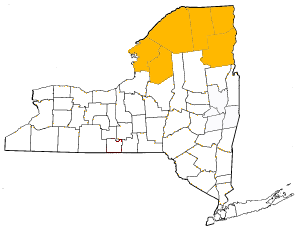
The towns and cities of New York's North Country were created by the U.S. state of New York as municipalities in order to give residents more direct say over local government. The North Country consists of Clinton County, Essex County, Franklin County, Jefferson County, Lewis County, and St. Lawrence County. When counties were first formed in 1683 the entire area was theoretically under the jurisdiction of Albany County though actually wilderness inhabited by Native Americans, by 1764 most of the area became effectively controlled by Albany County. The state would sell off this land to settlers and speculators, most notably as part of the Old Military Tract (1786) to veterans of the US Revolutionary War and as Macomb's Purchase (1791) to Alexander Macomb. In 1772 the northern and western portions of Albany County was divided into two counties– Tryon and Charlotte. Tryon encompassed Lewis, Jefferson, and St. Lawrence counties along with the western section of Franklin; Tryon was renamed Montgomery in 1784. Charlotte encompassed Clinton, Essex, and the majority of Franklin County; the name of the county was changed to Washington County in 1784. In 1788 Clinton County was split from Washington, Essex was formed from Clinton in 1799 and Franklin was formed from Clinton in 1808. Montgomery County's North Country area went to Herkimer County on that county's formation in 1791, but western Franklin and eastern St. Lawrence were returned to Montgomery in 1797. In 1798 Lewis, Jefferson, and western St. Lawrence became part of the newly formed Oneida County from Herkimer in 1798, leaving only central St. Lawrence County as part of Herkimer. In 1801 the future St. Lawrence and Franklin counties which were portions of Montgomery, Herkimer, and Oneida were transferred to Clinton County; the next year in 1802 St. Lawrence was formed as a county. In 1805 both Lewis and Jefferson counties were formed from Oneida County.

<span class="mw-page-title-main">38th New York State Legislature</span> New York state legislative session

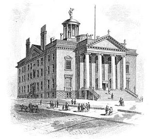
The 38th New York State Legislature, consisting of the New York State Senate and the New York State Assembly, met from September 26, 1814, to April 18, 1815, during the eighth year of Daniel D. Tompkins's governorship, in Albany.

<span class="mw-page-title-main">65th New York State Legislature</span> New York state legislative session

The 65th New York State Legislature, consisting of the New York State Senate and the New York State Assembly, met from January 4 to September 7, 1842, during the fourth year of William H. Seward's governorship, in Albany.

<span class="mw-page-title-main">69th New York State Legislature</span> New York state legislative session

The 69th New York State Legislature, consisting of the New York State Senate and the New York State Assembly, met from January 6 to May 13, 1846, during the second year of Silas Wright's governorship, in Albany.

<span class="mw-page-title-main">70th New York State Legislature</span> New York state legislative session

The 70th New York State Legislature, consisting of the New York State Senate and the New York State Assembly, met from January 5 to December 15, 1847, during the first year of John Young's governorship, in Albany.

Charles A. Fowler was an American lawyer and politician from New York.

References

  1. 1 2 3 4 5 6 7 8 9 10 11 12 13 Laws of the State of New York, Vol. 2; 1785-1788. State of New York. 1886. p. 748. Retrieved August 31, 2009.
  2. "Capital District Community Loan Fund". Archived from the original on August 10, 2009. Retrieved September 6, 2009.
  3. "Governmental Units". John B. Deitz. Retrieved May 18, 2009.
  4. 1 2 3 The Colonial Laws of New York, Vol. 5; 1769-1775. James B. Lyon (State of New York). 1894. p. 383. Retrieved September 1, 2009.
  5. 1 2 Laws of the State of New York, Vol. 2; 1785-88. State of New York. 1886. p. 196. Retrieved September 1, 2009.
  6. Statutes at Large of the State of New York, Vol. 7; 1867-1870. Weed, Parsons & Company. 1870. p. 405. Retrieved September 2, 2009.
  7. Charles Lincoln (1906). The Constitutional History of New York; Vol. 4. The Lawyers Co-operative Publishing Company. p.  401 . Retrieved April 5, 2009. the constitutional history of new york 1906.
  8. 1 2 National Reporter System (1898). New York Supplement, Vol. 50. W.C. Little & Co. pp. 488–491. Retrieved April 5, 2009.
  9. New York State Session Laws, Vol. 1. State of New York. 1897. p. 323.
  10. Laws of the State of New York, Vol. 2; 1785-88. State of New York. 1886. p. 508. Retrieved September 7, 2009.
  11. Proceedings of the New York State Historical Association. New York State Historical Association. 1916. p. 255. Retrieved September 2, 2009.
  12. Laws of the State of New York, Vol. 2; 1788-92. Thomas Greenleaf (State of New York). 1792. p. 214. Retrieved September 1, 2009.
  13. Ruth Higgins (1931). Expansion in New York. Ohio State University. p. 52. Retrieved September 2, 2009.
  14. General Laws of the State of New York, passed in 1915. West Publishing Company. 1915. p.  803 . Retrieved September 2, 2009. an act to incorporate the city of saratoga springs.
  15. General Laws of the State of New York, passed in 1915. West Publishing Company. 1915. p.  795 . Retrieved September 2, 2009. mechanicville.
  16. 1 2 "Warren County Historical Society" . Retrieved March 18, 2009.
  17. Laws of the State of New York, Vol. 2; 1788-92. Thomas Greenleaf (State of New York). 1792. p.  457 . Retrieved September 1, 2009. schoharie patent new york law.
  18. The Colonial Laws of New York, Vol. 5; 1769-75. James B. Lyon (State of New York). 1894. p. 773. Retrieved September 1, 2009.
  19. State of New York (1894). Colonial Laws of New York, Vol. II; 1720-1737. James B. Lyon. Retrieved January 29, 2010. july 23.

Further reading