Highlandville, Missouri

Last updated
Highlandville, Missouri
Christian County Missouri Incorporated and Unincorporated areas Highlandville Highlighted.svg
Location of Highlandville, Missouri
Coordinates: 36°56′34″N93°17′11″W / 36.94278°N 93.28639°W / 36.94278; -93.28639 Coordinates: 36°56′34″N93°17′11″W / 36.94278°N 93.28639°W / 36.94278; -93.28639
Country United States
State Missouri
County Christian
Area
[1]
  Total4.93 sq mi (12.76 km2)
  Land4.92 sq mi (12.75 km2)
  Water0.01 sq mi (0.02 km2)
Elevation
[2]
1,381 ft (421 m)
Population
 (2020)
  Total963
  Density195.65/sq mi (75.55/km2)
Time zone UTC-6 (Central (CST))
  Summer (DST) UTC-5 (CDT)
ZIP code
65669
Area code 417
FIPS code 29-32068 [3]
GNIS feature ID0735649 [2]

Highlandville is a city in Christian County, Missouri, United States. The population was 963 at the 2020 census. [4] It is part of the Springfield, Missouri Metropolitan Statistical Area.

Contents

History

A post office called Highlandville has been in operation since 1872. [5] The city was named on account of its lofty elevation. [6]

Geography

Highlandville is located at 36°56′34″N93°17′11″W / 36.94278°N 93.28639°W / 36.94278; -93.28639 (36.942690, −93.286447). [7]

According to the United States Census Bureau, the city has a total area of 5.03 square miles (13.03 km2), of which 5.02 square miles (13.00 km2) is land and 0.01 square miles (0.03 km2) is water. [8]

Demographics

Historical population
CensusPop.Note
1940 76
2000 872
2010 9114.5%
2020 9635.7%
U.S. Decennial Census [9]

2010 census

At the 2010 census, [10] there were 911 people, 348 households and 259 families living in the city. The population density was 181.5 inhabitants per square mile (70.1/km2). There were 380 housing units at an average density of 75.7 per square mile (29.2/km2). The racial makeup of the city was 97.4% White, 0.1% African American, 1.1% Native American, and 1.4% from two or more races. Hispanic or Latino of any race were 0.4% of the population.

There were 348 households, of which 33.9% had children under the age of 18 living with them, 58.3% were married couples living together, 10.9% had a female householder with no husband present, 5.2% had a male householder with no wife present, and 25.6% were non-families. 19.8% of all households were made up of individuals, and 7.5% had someone living alone who was 65 years of age or older. The average household size was 2.62 and the average family size was 2.98.

The median age was 38.7 years. 25.6% of residents were under the age of 18; 8.5% were between the ages of 18 and 24; 23.1% were from 25 to 44; 30.7% were from 45 to 64; and 12% were 65 years of age or older. The gender makeup of the city was 48.8% male and 51.2% female.

2000 census

At the 2000 census, [3] there were 872 people, 321 households and 248 families living in the city. The population density was 175.2 inhabitants per square mile (67.6/km2). There were 347 housing units at an average density of 69.7 per square mile (26.9/km2). The racial makeup of the city was 97.25% White, 1.03% Native American, 0.34% from other races, and 1.38% from two or more races. Hispanic or Latino of any race were 0.92% of the population.

There were 321 households, of which 38.0% had children under the age of 18 living with them, 58.9% were married couples living together, 14.6% had a female householder with no husband present, and 22.7% were non-families. 19.6% of all households were made up of individuals, and 5.6% had someone living alone who was 65 years of age or older. The average household size was 2.72 and the average family size was 3.10.

28.7% of the population were under the age of 18, 9.3% from 18 to 24, 32.0% from 25 to 44, 23.1% from 45 to 64, and 7.0% who were 65 years of age or older. The median age was 34 years. For every 100 females, there were 104.7 males. For every 100 females age 18 and over, there were 103.3 males.

The median household income was $31,767 and the median family income was $33,229. Males had a median income of $24,125 and females $20,682. The per capita income was $12,442. About 14.4% of families and 17.9% of the population were below the poverty line, including 25.2% of those under age 18 and 16.1% of those age 65 or over.

Related Research Articles

<span class="mw-page-title-main">Hutchinson Island South, Florida</span> CDP in Florida, United States

Hutchinson Island South is a census-designated place (CDP) on the barrier island of Hutchinson Island in St. Lucie County, Florida, United States. The South in its name refers to its location in the southern part of St. Lucie County, as it is actually in the central part of the island as a whole. The population was 4,846 at the 2000 census. It is part of the Port St. Lucie Metropolitan Statistical Area. Its mail is delivered from Jensen Beach 34957 in nearby Martin County. The Jensen Beach post office has a postal contract substation known as Hutchinson Beach located at 11007 South Ocean Drive, but it offers only post office boxes and counter services.

<span class="mw-page-title-main">Parma, Idaho</span> City in Canyon County, Idaho, United States

Parma is a city in Canyon County, Idaho, United States. The population was 1,983 at the 2010 census, up from 1,771 in 2000. It is the fourth largest city in the county and the largest in the rural western portion. It is part of the Boise City–Nampa, Idaho Metropolitan Statistical Area.

<span class="mw-page-title-main">Port Huron Township, Michigan</span> Charter township in Michigan, United States

Port Huron Charter Township is a charter township of St. Clair County in the U.S. state of Michigan. The population was 10,654 at the 2010 Census. The city of Port Huron is adjacent to the township.

<span class="mw-page-title-main">Blomkest, Minnesota</span> City in Minnesota, United States

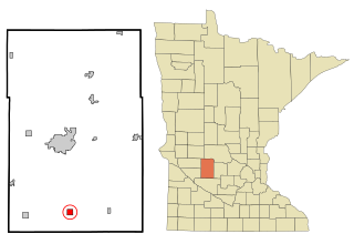
Blomkest is a city in Kandiyohi County, Minnesota, United States. The population was 157 at the 2010 census.

<span class="mw-page-title-main">Derma, Mississippi</span> Town in Mississippi, United States

Derma is a town in Calhoun County, Mississippi, United States. The population was 1,025 at the 2010 census.

<span class="mw-page-title-main">East Lynne, Missouri</span> City in Missouri, United States

East Lynne is a city in eastern Cass County, Missouri The population was 303 at the 2010 census. It is part of the Kansas City metropolitan area within the United States.

<span class="mw-page-title-main">Spokane, Missouri</span> Census-designated place in Missouri, United States

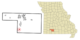
Spokane is a census-designated place in Christian County, Missouri, United States. The population was 177 at the 2010 census. It is part of the Springfield, Missouri, Metropolitan Statistical Area.

<span class="mw-page-title-main">Pilot Grove, Missouri</span> City in Missouri, United States

Pilot Grove is a city in the Pilot Grove Township in northern Cooper County, Missouri, United States. The population was 768 at the 2010 census.

<span class="mw-page-title-main">Urbana, Missouri</span> City in Missouri, United States

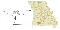
Urbana is a city in Dallas County, Missouri, United States. The population was 414 at the 2010 census. It is part of the Springfield, Missouri Metropolitan Statistical Area.

<span class="mw-page-title-main">Urich, Missouri</span> City in Missouri, United States

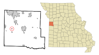
Urich is a city in Henry County, Missouri, United States. The population was 505 at the 2010 census.

<span class="mw-page-title-main">Linneus, Missouri</span> City in Missouri, United States

Linneus is a small city in Linn County, Missouri, United States. The population was 281 at the 2020 census. It is the county seat of Linn County.

<span class="mw-page-title-main">Meta, Missouri</span> City in Missouri, United States

Meta is a city in Osage County, Missouri, United States. The population was 180 at the 2020 census. It is part of the Jefferson City, Missouri Metropolitan Statistical Area and is also the world headquarters of Diamond Pet Foods.

<span class="mw-page-title-main">Smithton, Missouri</span> City in Missouri, United States

Smithton is a city in Pettis County, Missouri, United States. The population was 570 at the 2010 census.

<span class="mw-page-title-main">Nelson, Missouri</span> City in Missouri, United States

Nelson is a city in Saline County, Missouri, United States. The population was 152 at the 2020 census.

<span class="mw-page-title-main">Country Club Hills, Missouri</span> City in Missouri, United States

Country Club Hills is a city in St. Louis County, Missouri, United States. The population was 1,274 at the 2010 census.

<span class="mw-page-title-main">Bloomsdale, Missouri</span> City in Missouri, United States

Bloomsdale is a city in Ste. Genevieve County, Missouri, United States. The population was 639 at the 2020 census.

<span class="mw-page-title-main">Merriam Woods, Missouri</span> City in Missouri, United States

Merriam Woods is a city in Taney County, Missouri, United States. The population was 2,006 at the 2020 census. It is part of the Branson, Missouri Micropolitan Statistical Area.

<span class="mw-page-title-main">Walker, Missouri</span> City in Missouri, United States

Walker is a city in Vernon County, Missouri, United States. The population was 199 at the 2020 census.

<span class="mw-page-title-main">Lake Annette, Missouri</span> City in Missouri, United States

Lake Annette is a city in Cass County, Missouri, United States. The population was 100 at the 2010 census. It is part of the Kansas City metropolitan area.

<span class="mw-page-title-main">Prairie Home, Missouri</span> City in Missouri, United States

Prairie Home is a town, with legal status as a city, in Cooper County, Missouri, United States. The population was 280 at the 2010 census.

References

  1. "ArcGIS REST Services Directory". United States Census Bureau. Retrieved August 28, 2022.
  2. 1 2 U.S. Geological Survey Geographic Names Information System: Highlandville, Missouri
  3. 1 2 "U.S. Census website". United States Census Bureau . Retrieved 2008-01-31.
  4. "Explore Census Data". data.census.gov. Retrieved 2021-12-09.
  5. "Post Offices". Jim Forte Postal History. Retrieved 19 September 2016.
  6. "Christian County Place Names, 1928–1945 (archived)". The State Historical Society of Missouri. Archived from the original on 24 June 2016. Retrieved 19 September 2016.{{cite web}}: CS1 maint: bot: original URL status unknown (link)
  7. "US Gazetteer files: 2010, 2000, and 1990". United States Census Bureau. 2011-02-12. Retrieved 2011-04-23.
  8. "US Gazetteer files 2010". United States Census Bureau. Archived from the original on January 12, 2012. Retrieved 2012-07-08.
  9. "Census of Population and Housing". Census.gov. Retrieved June 4, 2015.
  10. "U.S. Census website". United States Census Bureau . Retrieved July 8, 2012.