53d Weather Reconnaissance Squadron

Last updated

53d Weather Reconnaissance Squadron
WC-130J Hercules of the 53rd Weather Reconnaissance Squadron.jpg
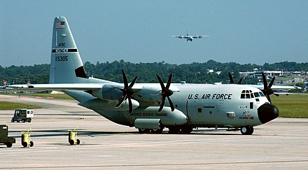
WC-130J of the 53d WRS
Active 1944–1947, 1951–1960, 1962–1991, 1993–present
CountryFlag of the United States.svg  United States
BranchFlag of the United States Air Force.svg  United States Air Force
Type Squadron
Role Tropical storm weather reconnaissance
Size 10 aircraft, 20 flight crews
Garrison/HQ Keesler Air Force Base, Mississippi
Nickname(s) Hurricane Hunters
Decorations Meritorious Unit Commendation
Air Force Outstanding Unit Award
Commanders
Current
commander
Lt. Col. Kevin C. Green Jr.
Insignia
53d Weather Reconnaissance Squadron emblem (1995) [1] [n 1] Hurricane Hunters.png
53d Weather Reconnaissance Squadron emblem (approved 1 April 1963) [2] 53d WRS Hurricane Hunters.png
53d Reconnaissance Squadron emblem (approved 15 November 1945) [2] 53 Reconnaissance Sq emblem.png
Aircraft flown
Reconnaissance WC-130J Hercules
WB-47E Stratojet
WB-50D Superfortress
WB-29A/B-29A Superfortress
RB-17/TB-17 Flying Fortress
B-25/WB-25D Mitchell
A WC-130J Hercules aircraft weather loadmaster of the 53d WRS performs pre-engine start-up inspection in St. Croix, Virgin Islands, on 16 September 2010. The SFMR antenna housing is visible under the starboard wing outboard of the number four engine. USAF WC-130 running through pre-engine start-up inspections.jpg
A WC-130J Hercules aircraft weather loadmaster of the 53d WRS performs pre-engine start-up inspection in St. Croix, Virgin Islands, on 16 September 2010. The SFMR antenna housing is visible under the starboard wing outboard of the number four engine.

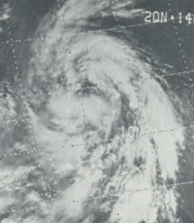
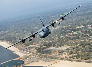
The 53d Weather Reconnaissance Squadron, also known by its nickname, Hurricane Hunters, is a flying unit of the United States Air Force, and "the only Department of Defense organization still flying into tropical storms and hurricanes." [3] Aligned under the 403d Wing of the Air Force Reserve Command (AFRC) and based at Keesler Air Force Base, Mississippi, with ten aircraft, it flies into tropical cyclones in the Atlantic Ocean, the Caribbean Sea, the Gulf of Mexico and the Central Pacific Ocean for the specific purpose of directly measuring weather data in and around those storms. The 53d WRS currently operates the Lockheed WC-130J aircraft as its weather data collection platform.

United States Air Force Air and space warfare branch of the United States Armed Forces

The United States Air Force (USAF) is the aerial and space warfare service branch of the United States Armed Forces. It is one of the five branches of the United States Armed Forces, and one of the seven American uniformed services. Initially formed as a part of the United States Army on 1 August 1907, the USAF was established as a separate branch of the U.S. Armed Forces on 18 September 1947 with the passing of the National Security Act of 1947. It is the youngest branch of the U.S. Armed Forces, and the fourth in order of precedence. The USAF is the largest and most technologically advanced air force in the world. The Air Force articulates its core missions as air and space superiority, global integrated intelligence, surveillance, and reconnaissance, rapid global mobility, global strike, and command and control.

United States Department of Defense United States federal executive department

The Department of Defense is an executive branch department of the federal government charged with coordinating and supervising all agencies and functions of the government concerned directly with national security and the United States Armed Forces. The department is the largest employer in the world, with nearly 1.3 million active duty servicemen and women as of 2016. Adding to its employees are over 826,000 National Guardsmen and Reservists from the four services, and over 732,000 civilians bringing the total to over 2.8 million employees. Headquartered at the Pentagon in Arlington, Virginia, just outside Washington, D.C., the DoD's stated mission is to provide "the military forces needed to deter war and ensure our nation's security".

403d Wing

The 403d Wing is a unit of the United States Air Force assigned to the Air Force Reserve Command. It is located at Keesler Air Force Base, Mississippi and employs a military manning authorization of more than 1,400 reservists, including some 250 full-time air reserve technicians. It also controls an active duty associate airlift squadron consisting of active duty regular Air Force personnel integrated into the operations of its reserve airlift squadron.

Contents

The squadron was activated in 1944 during World War II as the 3rd Weather Reconnaissance Squadron, tracking weather in the North Atlantic between North America and Europe. Redesignated the 53d Weather Reconnaissance Squadron in 1945, the term "Hurricane Hunters" was first applied to its activities in 1946. The 53d became a part of the USAF before its inactivation in 1947, was reactivated in 1951 as a long range weather reconnaissance unit based in Bermuda and England, and since 1963 has been based in the southern United States or in Puerto Rico with its primary mission the measurement of tropical cyclones. The 53d WRS moved to its present home station at Keesler AFB in 1973, and after being briefly inactivated again between 1991 and 1993, became an Air Force Reserve unit.

Bermuda British overseas territory in the North Atlantic Ocean

Bermuda is a British Overseas Territory in the North Atlantic Ocean. It is approximately 1,070 km (665 mi) east-southeast of Cape Hatteras, North Carolina; 1,236 km (768 mi) south of Cape Sable Island, Nova Scotia; and 1,759 km (1,093 mi) northeast of Cuba. The capital city is Hamilton. Bermuda is self-governing, with its own constitution and its own government, which enacts local laws, while the United Kingdom retains responsibility for defence and foreign relations. As of July 2018, its population is 71,176, the highest of the British overseas territories.

Puerto Rico Unincorporated territory of the United States

Puerto Rico, officially the Commonwealth of Puerto Rico and briefly called Porto Rico, is an unincorporated territory of the United States located in the northeast Caribbean Sea, approximately 1,000 miles (1,600 km) southeast of Miami, Florida.

The Hurricane Hunters of the Air Force Reserve are distinct from those of the Department of Commerce's NOAA Hurricane Hunters, based at Lakeland Linder International Airport, Florida, [4] who use a pair of Lockheed WP-3D Orion and a Gulfstream IV-SP aircraft to also fly weather reconnaissance, data collection and scientific research missions. In accordance with its memorandum of agreement with NOAA, AFRC maintains a capability in the 53d WRS for five sorties per day from its home station and two deployed locations in support of requirements for the National Hurricane Operations Plan, or two sorties a day during winter storm seasons. The 53d also provides a subunit, the Chief, Aerial Reconnaissance Coordination, All Hurricanes ("CARCAH"), at the National Hurricane Center to coordinate the activities of both organizations. [5]

NOAA Hurricane Hunters

The NOAA Hurricane Hunters are a group of aircraft used for hurricane reconnaissance by the United States National Oceanic and Atmospheric Administration (NOAA). They fly through hurricanes to help forecasters and scientists gather operational and research data. The crews also conduct other research projects including ocean wind studies, winter storm research, thunderstorm research, coastal erosion, and air chemistry flights.

Lakeland Linder International Airport Airport in Lakeland, Florida

Lakeland Linder International Airport is a public airport five miles southwest of Lakeland, in Polk County, Florida. The Federal Aviation Administration (FAA) National Plan of Integrated Airport Systems for 2017–2021 categorized it as a national reliever facility for Tampa International Airport. The airport has a Class 1 Federal Aviation Regulation (FAR) Part 139 operating certificate allowing passenger airline flights. Annually, around March–April, the airport hosts the Sun 'n Fun International Fly-In and Expo, a six-day fly-in, airshow and aviation convention. It is the second largest such event in the United States after the Experimental Aircraft Association's (EAA) annual "AirVenture" event each summer at Wittman Regional Airport (OSH) in Oshkosh, Wisconsin. During the week of Sun 'n Fun, Lakeland Linder International Airport becomes the world's busiest airport with 60,000+ aircraft movements. In 2017 the airport had 129,504 aircraft operations, averaging 355 per day: 97% general aviation, 2% military, 1% air taxi, and <1% airline. In August 2018, 248 were aircraft based at the airport: 161 single-engine, 35 multi-engine, 42 jet, 9 helicopter, and 1 glider.

Lockheed WP-3D Orion

The Lockheed WP-3D Orion is a highly modified P-3 Orion used by the Aircraft Operations Center division of the National Oceanic and Atmospheric Administration (NOAA). Only two of these aircraft exist, each incorporating numerous features for the role of collecting weather information. During hurricane season, the WP-3Ds are deployed for duty as hurricane hunters. The aircraft also support research on other topics, such as Arctic ice coverage, air chemistry studies, and ocean water temperature and current analysis.

Concurrent with its operational mission, the 53d WRS is also tasked with recruiting, organizing and training assigned personnel to perform aerial weather reconnaissance, and its air crews are qualified to handle tactical airlift missions.

History

Operational history

Hurricane hunting

Aerial reconnaissance of tropical storms first began in September 1935. In that year the United States Weather Bureau decentralized its hurricane warning system, which depended to a great extent on reports from ships at sea, opening three warning centers in San Juan, Puerto Rico; Jacksonville, Florida; and New Orleans, Louisiana. In August the Jacksonville center followed the progress of a developing hurricane east of the Bahamas, determining that it would pass through the Straits of Florida and strike the north coast of Cuba. It contacted the Cuban weather service when ship information was no longer available, but track of the storm was lost when the Cubans observed no evidence of it. Acting on a report from a Pan American Airlines pilot, a weather observation flight was requested of the Cuban Army Ar Corps and on 2 September 1935 its chief training pilot, American expatriate Capt. Leonard J. Povey, volunteered to locate the system. Although he was unable to penetrate the storm in his open-cockpit Curtiss Hawk II biplane, Povey provided information that indicated the hurricane was moving north into the Florida Keys. [6] The destructiveness of the 1935 Labor Day hurricane prompted Povey to recommend a regular aerial hurricane patrol. [7] [n 2]

San Juan, Puerto Rico Municipality in Puerto Rico, United States

San Juan is the capital and most populous municipality in the Commonwealth of Puerto Rico, an unincorporated territory of the United States. As of the 2010 census, it is the 46th-largest city under the jurisdiction of the United States, with a population of 395,326. San Juan was founded by Spanish colonists in 1521, who called it Ciudad de Puerto Rico. Puerto Rico's capital is the third oldest European-established capital city in the Americas, after Santo Domingo, in the Dominican Republic, founded in 1496 and Panama City, in Panama, founded in 1519. Several historical buildings are located in San Juan; among the most notable are the city's former defensive forts, Fort San Felipe del Morro and Fort San Cristóbal, and La Fortaleza, the oldest executive mansion in continuous use in the Americas.

Jacksonville, Florida Largest city in Florida

Jacksonville is the most populous city in Florida, the most populous city in the southeastern United States and the largest city by area in the contiguous United States. It is the seat of Duval County, with which the city government consolidated in 1968. Consolidation gave Jacksonville its great size and placed most of its metropolitan population within the city limits. As of 2017 Jacksonville's population was estimated to be 892,062. The Jacksonville metropolitan area has a population of 1,631,488 and is the fourth largest in Florida.

Straits of Florida strait close to Florida, USA

The Straits of Florida, Florida Straits, or Florida Strait is a strait located south-southeast of the North American mainland, generally accepted to be between the Gulf of Mexico and the Atlantic Ocean, and between the Florida Keys (U.S.) and Cuba. It is 150 km (93 mi) wide at the narrowest point between Key West and the Cuban shore, and has been sounded to a depth of 6,000 feet (1,800 m). The strait carries the Florida Current, the beginning of the Gulf Stream, from the Gulf of Mexico.

The 1943 Surprise Hurricane, which struck Houston during World War II, marked the first intentional meteorological flight into a hurricane. That summer, British pilots being trained as instrument instructor pilots at Bryan Army Airfield heard that the school was evacuating its AT-6 Texan trainers in the face of the oncoming hurricane, and began teasing their instructors about the airworthiness of the aircraft. Instrument flying school commander USAAF Lt. Col. Joseph B. Duckworth, a former airline pilot with Eastern Airlines who had developed instrument procedures for the carrier, bet his RAF students that he could safely fly into the storm and return. On 27 July 1943 he took out one of the trainers with 2nd Lt Ralph M. O'Hair navigating and flew it straight into the eye of the storm. After he returned safely, the base's only weather officer, 1st Lt William H. Jones-Burdick, took over the navigator's seat and Duckworth flew into the storm (now over land) a second time, this time recording their observations and measuring temperatures within the storm. [8] [9] The flights demonstrated that hurricane reconnaissance flights were feasible. [10] [11]

1943 Surprise Hurricane Category 1 Atlantic hurricane in 1943

The 1943 Surprise hurricane was the first hurricane to be entered by a reconnaissance aircraft. The first tracked tropical cyclone of the 1943 Atlantic hurricane season, this system developed as a tropical storm while situated over the northeastern Gulf of Mexico on July 25. The storm gradually strengthened while tracking westward and reached hurricane status late on July 26. Thereafter, the hurricane curved slightly west-northwestward and continued intensifying. Early on July 27, it became a Category 2 hurricane on the modern-day Saffir–Simpson hurricane wind scale and peaked with winds of 105 mph (165 km/h). The system maintained this intensity until landfall on the Bolivar Peninsula in Texas late on July 27. After moving inland, the storm initially weakened rapidly, but remained a tropical cyclone until dissipating over north-central Texas on July 29.

Houston City in Texas, United States

Houston is the most populous city in the U.S. state of Texas and the fourth most populous city in the United States, with a census-estimated population of 2.312 million in 2017. It is the most populous city in the Southern United States and on the Gulf Coast of the United States. Located in Southeast Texas near Galveston Bay and the Gulf of Mexico, it is the seat of Harris County and the principal city of the Greater Houston metropolitan area, which is the fifth most populous metropolitan statistical area (MSA) in the United States and the second most populous in Texas after the Dallas-Fort Worth MSA. With a total area of 627 square miles (1,620 km2), Houston is the eighth most expansive city in the United States ; it is the largest city in the United States by total area, whose government is similarly not consolidated with that of a county or borough. Though primarily in Harris County, small portions of the city extend into Fort Bend and Montgomery counties.

United States Army Air Forces Aerial warfare branch of the United States army from 1941 to 1947

The United States Army Air Forces, informally known as the Air Force,or United States Army Air Force, was the aerial warfare service of the United States during and immediately after World War II (1939/41–1945), successor to the previous United States Army Air Corps and the direct predecessor of the United States Air Force of today, one of the five uniformed military services. The AAF was a component of the United States Army, which in 1942 was divided functionally by executive order into three autonomous forces: the Army Ground Forces, the Services of Supply, and the Army Air Forces. Each of these forces had a commanding general who reported directly to the Army Chief of Staff.

24 days later, on 19 August 1943, the AAF weather station at Waller Field, Trinidad, recorded unusually low pressures and received a similar report from Beane Field on Saint Lucia. Together with a report of high winds to the east from a U.S. Navy aircraft landing at Naval Operating Base Trinidad, the data prompted the first weather reconnaissance mission to locate a previously unreported tropical disturbance, which was flown the next morning. The flight, made by a B-25 Mitchell medium bomber assigned to the 25th Bombardment Group (an anti-submarine unit at nearby Edinburgh Field), proceeded from Waller to Barbados and then due east at altitudes between 8,000 ft (2,400 m) and 600 ft (180 m) into the heart of Hurricane III of 1943. Using standard navigational position fixes, the mission plotted observations inflight on a chart as they proceeded and transmitted them to Beane Field for relay to Waller and Borinquen Field, Puerto Rico. [n 3] [12]

Waller Air Force Base

Waller Air Force Base is a former United States Army Air Forces World War II air base located in northeastern Trinidad. It is located about 5 miles (8 km) southwest of Valencia south of the Churchill-Roosevelt Highway and roughly 32 km from the capital city Port of Spain.

Trinidad The larger of the two major islands which make up Trinidad and Tobago

Trinidad is the larger and more populous of the two major islands of Trinidad and Tobago. The island lies 11 km (6.8 mi) off the northeastern coast of Venezuela and sits on the continental shelf of South America. Though geographically part of the South American continent, from a socio-economic standpoint it is often referred to as the southernmost island in the Caribbean. With an area of 4,768 km2 (1,841 sq mi), it is also the fifth largest in the West Indies.

Beane Air Force Base was a United States Air Force base located near Vieux Fort, Saint Lucia, in the Caribbean Sea. It is now the site of Hewanorra International Airport.

53d WRS history

The 53d WRS was activated in 1944 at Presque Isle Army Air Field, Maine, originally as the 3 WRS. [1] Many of its missions were flown from a forward base at Gander, Newfoundland, using B-25s. Its original mission was to fly weather tracks along aircraft ferry routes between North America and Allied Western Europe. During the 1946 season, when the 53d WRS acquired the Boeing RB-29 (later WB-29) Superfortress as its primary aircraft, the term "Hurricane Hunters" was first used to describe its missions. While not an ideal weather reconnaissance platform, the WB-29 proved to be comparatively safe and reliable. The first medium level penetration of a hurricane took place on 19 October 1947 by an RB-29 of the 53d WRS into Hurricane Love near Bermuda, validating penetration of tropical storms at lower altitudes as reasonably safe. [13]

From Gander, the squadron moved to New Hampshire; Florida; Kindley Field, Bermuda; RAF Burtonwood, England, with forward basing at Dhahran, Saudi Arabia; Bermuda for a short time, and Hunter Air Force Base, Georgia. In 1966, now flying the Lockheed WC-130, the 53d WRS once again left the United States, this time for Ramey Air Force Base, Puerto Rico. When Ramey closed in 1973, the Hurricane Hunters relocated to their present location at Keesler AFB, Mississippi. [10]

53d WRS Boeing WB-29A weathership landing at its base at RAF Burtonwood in 1954 Boeing WB-29A 462090 53 WRS BWD 09.54 edited-5.jpg
53d WRS Boeing WB-29A weathership landing at its base at RAF Burtonwood in 1954
53d WRS Boeing WB-50D weathership landing at RAF Burtonwood in 1956. The observation and sampling station is on top of the rear fuselage Boeing B-50 (WB-50D) 9261 MATS Burtonwood 29.04.56 edited-2.jpg
53d WRS Boeing WB-50D weathership landing at RAF Burtonwood in 1956. The observation and sampling station is on top of the rear fuselage

On 18 September 1953, while based at Kindley, Bermuda, the squadron suffered its only mission-related loss of an aircraft, a WB-29. [n 4] Returning to base with a runaway propeller[ clarification needed ] on the inboard engine of the right wing, the propeller separated from its shaft and struck the engine beside it, causing both the wing and outboard engine to catch fire. The pilot ordered an immediate bailout, but the aircraft went out of control and only three of the 10-man crew survived. [14] [n 5]

In 1965 the 53d WRS became the first squadron of the Air Weather Service to operate the WC-130 after its designation as such, and from Ramey flew the first WC-130 Hurricane Hunter mission on 27 August 1965, penetrating the eye of Hurricane Betsy. [15]

In the 1970s, after its move to Keesler, the 53d participated in two "firsts" in the changing of regulations to permit women to be qualify as aircrew. Sgt. Vickiann Esposito became the first female dropsonde operator and possibly the first fully qualified aircrew member (excepting flight nurses) in Air Force history, approved by Headquarters Air Force in December 1973 as a waiver of the regulation prohibiting the assignment of women, over the initial objections of the commanding general of the Air Mobility Command. In October 1977, after the regulation had been rescinded, 1st Lt. Florence Fowler became one of the first two women to be rated as navigators (now combat systems officers). [16] [n 6]

In 1976, the 815th Tactical Airlift Squadron of the Air Force Reserve, also based at Keesler, was redesignated the 815th Weather Squadron "Storm Trackers" and served as an associate squadron to the 53d until 1987, when the 815th reverted to a tactical airlift unit because of reduced numbers of WC-130s. The Regular Air Force's 53d WRS was inactivated in June 1991 for budgetary reasons and its assets and personnel transferred to the 815th TAS, which formed a flight to assume the weather recon mission while continuing its airlift role as well. On 1 November 1993, as a result of the impact of Hurricane Andrew the year before, the 53d WRS was reactivated as a full-time Air Force Reserve squadron to take over the weather reconnaissance mission from the 815th AS. [17]

The WC-130H airframes flown by the 53d WRS were originally built in 1964–65 as C-130Es. Hurricane Andrew had also demonstrated a need for upgraded models to continue the Hurricane Hunter mission, and funding for ten replacements was authorized by Congress in FY1998. On 11 October 1999, the 53d WRS received its first Lockheed WC-130, and flew its first hurricane mission in the new model on 16 November, into Hurricane Lenny. Problems with the new model, primarily damage to its composite material 6-bladed propellers from hail and ice and a lack of sensitivity in its color radar images, delayed its Initial Operational Capability until just before the 2005 hurricane season. The propeller problem was overcome by bonding a metal sleeve to the leading edge of each blade and the radar issue by changes in the radar software coding. [18]

While in conversion to the new airframe, the unit continued its mission of aerial weather reconnaissance and added a new weather-related mission type in 2003, using the WC-130Js to drop buoys ahead of impending tropical storms. In 2004, the unit started training to support tactical airlift missions in addition to its weather mission. The landfall of Hurricane Katrina on 29 August 2005 caused devastating damage to Keesler. An estimated one-third of the members of the parent 403d Wing lost a home or had it extensively damaged. [19] Yet the equipment and personnel of the squadron, flying out of Dobbins Air Reserve Base near Atlanta, Georgia when the hurricane struck, never missed a tasked mission during Katrina or follow-up storms. [10]

The operations of the 53d WRS were affected by the federal budget sequestration of 2013. Furloughs of personnel, amounting to two days in every pay period per member, resulted in a 20% cut in capability, according to the wing commander of the 403d Wing on 24 July 2013. While sequestration was in effect, this meant the squadron was capable of working only two storms simultaneously at full mission scheduling instead of the normal three, and that pace sustainable only for five or six days. [20]

Hurricane Hunter mission

WC-130H Hercules in flight Wc 130.jpg
WC-130H Hercules in flight
WC-130J Hercules on the ramp at Dobbins ARB, Georgia, with another landing behind it, during reployment for Hurricane Katrina. Lockheed Martin WC-130J.jpg
WC-130J Hercules on the ramp at Dobbins ARB, Georgia, with another landing behind it, during reployment for Hurricane Katrina.

The 53d Weather Reconnaissance Squadron, using the call signs Teal 70 to Teal 79, [n 7] flies missions into hurricanes and weather systems for research purposes and observation. Although satellite data has revolutionized weather forecasters' ability to detect early signs of tropical cyclones before they form, there are still many important tasks for which this information is not suitable. Satellites cannot determine the interior barometric pressure of a hurricane, nor provide accurate wind speed information. These data are needed to accurately predict hurricane development and movement. Because satellites cannot collect the data and ships are too slow and vulnerable, the only viable way to collect this information is with aircraft. Meteorological parameters measured, in order of priority, are:

The 53d WRS is equipped with ten pallet-instrumented [n 8] WC-130J aircraft to collect the required meteorological data. [n 9] The area of responsibility for the "Hurricane Hunters" is from midway through the Atlantic Ocean west to the Hawaiian Islands, although they have also been tasked to fly into typhoons in the Pacific Ocean on occasion, as well as gather data in winter storms. [n 10] The Hurricane Hunters are tasked to support 24-hour-a-day continuous operations with the ability to fly up to 3 storms at a time with a response time of 16 hours. This necessitates a mission organization of ten full-time aircrews and ten part-time. [23]

The WC-130J employs a standard five person crew element of a pilot, co-pilot, Combat Systems Officer (CSO), aerial reconnaissance weather officer (ARWO), and a weather loadmaster/dropsonde operator, with a second loadmaster assigned when required. The ARWO is the flight meteorologist and acts as flight director inside the storm system. Operational crews train twice monthly at Keesler AFB and fly weather recon missions when available. [23] 53d WRS pilots and loadmasters go through their initial C-130J training at the 314th Airlift Wing's tactical airlift training center at Little Rock Air Force Base, Arkansas. CSOs and ARWOs from the 53d WRS have no formal school and train in-house at Keesler utilizing an Air Education and Training Command-approved syllabus for their specialized mission training. [24]

The 53d WRS uses Henry E. Rohlsen Airport on St. Croix as its primary forward-deployed location for North Atlantic basin operations. Each May since 1996, when it switched operations from Antigua to the U.S. Virgin Islands to operate from U.S. soil, the squadron prepositions maintenance equipment and materiel at Rohlsen in preparation for the coming season. From July through September three crews are commonly forward-deployed to St. Croix at any given time with rotations of a week's deployment per month. [25]

Since 1969, the 53d WRS also performs winter storm weather reconnaissance off both coasts of the United States between 1 November and 15 April in support of the National Centers for Environmental Prediction. These missions are flown at the WC-130's service ceiling of 30,000 ft (9,100 m), which subjects them to turbulence, lightning and icing. The crews collect data ahead of weather systems, dropping weather buoys along their routes, before they move off the eastern seaboard to help determine if the conditions are right to intensify into Nor'easter blizzards. In 1997 and 1998, the Hurricane Hunters also flew winter storms in the Gulf of Alaska. The predetermined tracks are six to eleven hours in duration, with one to three missions flown per major winter storm event. [26] Coverage of winter storms in the eastern Pacific has become standard during the month of February, operating TDY from either Elmendorf AFB, Alaska, or Hickam AFB, Hawaii. [27]

53rd Weather Reconnaissance Squadron and FEMA staff discuss Hurricane Hunter aircraft operations aboard an Air Force Reserve WC-130J Super Hercules C130 MSGT 2 5-11-2018 medium.jpg
53rd Weather Reconnaissance Squadron and FEMA staff discuss Hurricane Hunter aircraft operations aboard an Air Force Reserve WC-130J Super Hercules

The 53d WRS works closely with the National Hurricane Center (NHC), a division of the National Weather Service (NWS) located in Miami, that tracks hurricanes to provide early warning service for Atlantic basin storms. It maintains a subunit, the Chief, Aerial Reconnaissance Coordination, All Hurricanes (CARCAH), at the NHC as a point-of-contact and provides the staff and equipment to coordinate Department of Commerce requirements for hurricane data, assign weather reconnaissance missions and monitor all data transmitted from weather reconnaissance aircraft of DOC and the 53d WRS. [10] To that end CARCAH is responsible for producing, publishing, and coordinating the Tropical Cyclone Plan of the Day (TCPOD) during hurricane season. [28] [n 11]

The 53d WRS maintains similarly configured satellite communications ground stations within CARCAH at the NHC and its facility at Keesler to receive and process data from the aircraft. The Keesler ground station is maintained as a backup to the primary system at NHC, which has greater data streaming capability, and would be manned by CARCAH personnel in the event of a long-term satellite communications failure at NHC. During temporary outages, 53d personnel at Keesler act as operators and relay data from the aircraft by land line to the CARCAH ground station. Processed data is transmitted to the Weather Product Management and Distribution System (WPMDS) of the Air Force Weather Agency at Offutt AFB, Nebraska, which then relays it to the NWS Telecommunication Gateway at Silver Spring, Maryland, for worldwide distribution. The Keesler site has direct communications capability with WPMDS in the event of land line/internet failure between Keesler and the NHC. The system also provides backup transmission paths to WPMDS using local NHC servers and satellite connection to Keesler in the event of internet outages, except if an outage originates at Offutt. [29]

Tropical cyclone operational profiles

When a tropical disturbance becomes suspect for development as a tropical or subtropical cyclone, the NHC assigns the system a temporary tracking ("Investigation") number [n 12] and requests the 53d WRS to determine if the winds are blowing in a counterclockwise rotation, indicating a "closed cyclonic circulation". This investigative mission is flown at an altitude of 500 ft (150 m)1,500 ft (460 m) above the ocean surface in a pattern designated by the ARWO aboard the mission WC-130 based on observed conditions. [n 13] The ARWO, using a stepped-frequency microwave radiometer (SFMR, or "smurf"), [27] [30] [n 14] continuously monitors ocean waves to determine wind speed and direction. The low-level wind and pressure fields provide an accurate picture for NHC forecasters. Investigative missions are usually flown during daylight and may be timed to arrive in the investigative area at first light in the morning or last light in the evening. Weak pressure gradients, large areas of calm, and light winds in areas of heavy convective activity often make vortex fixes difficult to obtain in areas of weak circulation, challenging the skills of the crews.

Once NHC determines that there is circulation within the disturbance, the mission becomes a sequentially numbered "fix" mission, conducted initially every six hours by rotating flights in cooperation with NOAA missions, and then at three-hour intervals as the storm moves within specified parameters. [23] [n 15] During the "fix" mission, the ARWO directs the aircraft to the true center or vortex of the storm by monitoring the radar presentation, temperature, pressure, and mapping the wind fields as the aircraft makes left-hand turns. Vortices determined by individual parameters including visual observation may not coincide at the same geographic location. Surface and upper-level centers may be displaced by many miles. In order to make a reliable evaluation of its size and configuration, the crew flies through the disturbance using "Flight Pattern Alpha" consisting of intercardinal headings with legs 105 nautical miles (190 km) in length. [n 16] The Alpha pattern is repeated at least twice during the mission, which will typically see a penetration of the eye of the system four times. Patterns may also be adjusted to meet circumstances encountered in the system. In August 2011, as Hurricane Irene neared the Delmarva Peninsula between landfalls, a 53d WRS ARWO directed a pattern with shorter legs and more rapid turnarounds because of the proximity of land, making seven center fixes in one flight. [19] Flight weather data is continuously collected and sent directly to the NHC by satellite communications. Since the WC-130J is not equipped for aerial refueling, the alpha pattern continues until minimum fuel reserve is reached, or until the NHC has received all the data it requires. [23]

Major hurricanes (Category 3 or higher in the Saffir–Simpson scale) are entered at approximately 10,000 ft (3,000 m) altitude. [n 17] While penetrating the eyewall, a dropsonde is released to determine the maximum sustained winds at the surface and a second dropsonde is released in the eye to detect the lowest pressure at the surface. After exiting the eye, the ARWO creates a Vortex Data Message that includes the precise latitude and longitude of the storm center as well as its maximum winds, maximum temperature, and minimum sea level pressure. [n 18] The average duration of a "Hurricane Hunter" mission is ten hours, with five to six hours on station, depending on the distance of the storm from base, when tasked to perform three fixes at three-hour intervals. [19]

Lineage

Activated on 31 August 1944
Redesignated 3d Reconnaissance Squadron, Weather, Heavy on 26 January 1945
Redesignated 53d Reconnaissance Squadron, Long Range, Weather on 15 June 1945
Redesignated 53d Reconnaissance Squadron, Very Long Range, Weather on 27 November 1945
Inactivated on 15 October 1947
Activated on 21 February 1951
Redesignated 53d Weather Reconnaissance Squadron on 15 February 1954
Discontinued on 18 March 1960
Inactivated on 30 June 1991

Assignments

Stations

Aircraft

53d WRS WC-130H WC130H.jpg
53d WRS WC-130H

Awards

Award streamerAwardDatesNotes
Streamer MUC Army.PNG Meritorious Unit Citation 23 May 1945–31 October 19453d Reconnaissance Squadron (later 53d Reconnaissance Squadron) [1]
AFOUA Streamer.JPG Air Force Outstanding Unit Award 1 December 1958–30 September 195953d Weather Reconnaissance Squadron [1]
AFOUA Streamer.JPG Air Force Outstanding Unit Award1 July 1967–30 June 196853d Weather Reconnaissance Squadron [1]
AFOUA Streamer.JPG Air Force Outstanding Unit Award1 January 1971-31 December 197153d Weather Reconnaissance Squadron [1]
AFOUA Streamer.JPG Air Force Outstanding Unit Award1 September 1975–1 May 197753d Weather Reconnaissance Squadron [1]
AFOUA Streamer.JPG Air Force Outstanding Unit Award16 July 1977–16 July 197953d Weather Reconnaissance Squadron [1]
AFOUA Streamer.JPG Air Force Outstanding Unit Award17 July 1979–15 June 198153d Weather Reconnaissance Squadron [1]
AFOUA Streamer.JPG Air Force Outstanding Unit Award1 April 1984–31 March 198653d Weather Reconnaissance Squadron [1]
AFOUA Streamer.JPG Air Force Outstanding Unit Award1 April 1986–31 March 198853d Weather Reconnaissance Squadron [1]
AFOUA Streamer.JPG Air Force Outstanding Unit Award1 November 1993–30 April 199453d Weather Reconnaissance Squadron [1]
AFOUA Streamer.JPG Air Force Outstanding Unit Award1 May 1994–30 April 199653d Weather Reconnaissance Squadron [1]
AFOUA Streamer.JPG Air Force Outstanding Unit Award1 May 1996–31 August 199753d Weather Reconnaissance Squadron [1]

Cable television series

The Weather Channel announced in January 2012 that it would be presenting a six-episode docu-reality series (Hurricane Hunters) in July 2012 depicting the operations of the 53d WRS during the 2011 hurricane season. [32] However even before its debut, the series and its network were beset by controversy when a 53d WRS member, Major (then Captain) Nicole L. Mitchell, an ARWO and an on-camera meteorologist for TWC from July 2004 to January 2011, revealed on 4 June 2012 that she had filed suit 9 September 2011 in the United States District Court for the Northern District of Georgia against The Weather Channel and its owners, NBC Universal and two private equity firms, Bain Capital and the Blackstone Group, claiming that the termination of her employment in 2010 was based on her part-time Air Force Reserve service, was discriminatory and was in violation of the Uniformed Services Employment and Reemployment Rights Act (USERRA) of 1994. [33] A second nine-segment season, filmed in August and October 2012, aired on The Weather Channel beginning in June 2013. [34] Mitchell subsequently became the Chief Meteorologist at Al Jazeera America and after September 2015 became the only remaining Air Force meteorologist with personal experience flying through Hurricane Katrina.

See also

Hurricane Hunters in fiction

A hurricane hunter aircraft was depicted in the 1974 movie Hurricane, penetrating a hurricane threatening the Gulf Coast in the Louisiana or Mississippi area. Spotting a small pleasure boat within the eye, they returned into the eye to guide a submarine, but the plane was lost in its attempt to exit a second time. The submarine rescued the boat's occupants.

Notes

Footnotes
  1. The emblem was personally modified by the Chief of Staff of the United States Air Force, but the changes were registered, but not approved formally. Robertson Factsheet, 53 Weather Reconnaissance Squadron (AFRC)
  2. Leonard James Povey was born in 1904 in Nashua, New Hampshire and served in the United States Army Air Service from 1922 to 1925. Also a barnstormer, he was recruited in 1934 by Col. Fulgencio Batista to re-organize the Cuban air force. Nicknamed "Upside-Down Povey", he is credited with inventing the Cuban Eight aerobatic maneuver in 1936 while flying a demonstration at an air show in Florida. In 1938 he returned to the United States to become a flight test inspector for the new Civil Aeronautics Authority (precursor to the FAA), and in 1941 became vice president of flying operations at the Embry-Riddle School of Aviation. During World War II he worked for Fairchild Aircraft developing training aircraft. (Biography of Len Povey, University of Texas at Dallas)
  3. The B-25, AAF s/n 43-5052, was flown by Capt. R.A. Field of the 10th Bombardment Squadron and carried weather officers Major I.I. Porush, Captain J. R. Fleming, and 1st Lt. P.W. Allen. A second flight, similar to Duckworth's, took off from Antigua with weather officer Capt. C.H. MacDougall aboard and also observed the storm.
  4. Swan 38, a WC-130H of the 53d's sister 54th Weather Reconnaissance Squadron, was lost on October 12, 1974, while flying an alpha pattern into Typhoon Bess 400 miles northeast of Clark Air Base in the Philippines. The Hurricane Hunter Association established the Swan 38 Memorial Scholarship for outstanding students in the 403d Wing. (Swan 38 Scholarship)
  5. The WB-29 was serial 44-62277, a converted B-29A.
  6. Lt. Fowler's navigation school classmate 1st Lt. Ramona L. Roybal became a WC-135 navigator with the 55th WRS at McClellan AFB at the same time. A month earlier, the first rated female pilot, 2nd Lt. Carole A. Scherer, had been assigned to fly WC-130s with the 54th WRS. The first Aerial Reconnaissance Weather Officer (ARWO) was 1st Lt. Nancy E. Holtgard, who was also assigned to the 54th WRS on Guam.
  7. The 53rd WRS picked up the call sign "Teal" in 1993 from the 815th TAS, which had used it when designated the 815th Weather Squadron and again after 1991 when it contained a Hurricane Hunter flight in addition to its tactical airlift flights. As an active force squadron the 53rd had previously used the call sign "Gull."
  8. Pallet instrumentation for the WC-130J's mission consists of a Communication Navigation Identification Unit (CNIU), Satellite Communication System (SATCOM), Advanced Vertical Atmospheric Profiling System (AVAPS) to receive and analyze dropsonde data, Atmospheric Sounding Processing Environment (ASPEN), and the Aerial Reconnaissance Weather Officer's computer with Weatherbird software package, all of which are described in External Links. Between May 2007 and February 2008 all ten WC-130J Weatherbirds were also equipped with wing-mounted Stepped-Frequency Microwave Radiometer ("Smurf") pods, described separately. In 2009 the SFMR systems were retrofitted with a new antenna that during heavy rains resulted in an over-calculation of light winds, caused by water intrusion in the radome through drain holes in the new antenna. The problem was identified during Hurricane Felicia and found to have affected 50% of missions flown during the season. It was corrected in September 2009 by sealing the drain holes.
  9. AF s/n 96-5300 through −5302, 97–5303 through −5306, 98–5307 and −5308, and 99-5309.
  10. The squadron previously tasked for tropical storm reconnaissance in the Western Pacific, the 54th WRS, was inactivated in 1987.
  11. The TCPOD is available at http://www.nhc.noaa.gov/ by clicking on Aircraft Recon under "Tools & Data" for Plan of the day.
  12. Numbers 90 through 99 in the cyclone numbering system are reserved for such disturbances. Although not required, the "90" series of cyclone numbers is assigned sequentially and normally reused throughout the calendar year. The number is further modified by a two-letter ocean basin code. Investigation AL97 (or "97L" in verbal shorthand) would be the seventh sequential disturbance in the North Atlantic basin, while Invest. EP92 (92E) is the second in the East Pacific basin north of the equator.
  13. "Suggested" investigative patterns are the X, Box, and Delta patterns, described and illustrated at NHOP 2015, pages 5–19 and 5–20.
  14. The SFMR is designed to continuously measure surface winds directly below the WC-130J, and is installed on the aircraft within a wing-mounted antenna pod. As the plane flies through a storm, the SFMR senses microwave radiation naturally emitted from foam created on the sea by winds at the surface. Computers determine wind speeds based on the levels of microwave radiation detected, extrapolated from the winds at the aircraft's altitude or from a dropsonde released from the aircraft. The SFMR can also determine rainfall rates within a system, which in addition to wind speeds at flight level, provides structural detail of the storm.
  15. A typical weather reconnaissance Tropical Cyclone Plan of the Day (TCPOD) is reproduced here. Up to four 6-hour fixes per day are conducted when a system is within 500 nautical miles of landfall and west of 55°W in the Atlantic, and up to eight 3-hour fixes per day if within 300 nautical miles of the coast of the United States, Hawaii, Puerto Rico, the Virgin islands, or DOD installations. Up to two "synoptic surveillance" missions per day may be flown on the periphery of systems with a potential for landfall. (NHOP 2015, p. 5–12).
  16. "5.8.1. Flight Pattern ALPHA Operational Details. 5.8.1.1. Flight Levels and Sequence. Flight levels will normally be 1,500 ft, 925 hPa, 850 hPa, or 700 hPa, depending on data requirements and flight safety. Legs will normally be 105 nm long and flown on intercardinal tracks (45 degrees off cardinal tracks). The pattern can be started at any intercardinal point and then repeated throughout the mission. Prior to starting an inbound or outbound track the aircrew should evaluate all available data, e.g., radar presentation, satellite photo, for flight safety. Once started on course, every effort should be made to maintain a straight track and the tasked altitude. A horizontal observation is required at each leg end point. This data is transmitted immediately. The ALPHA pattern may be modified to satisfy unique customer requirements (such as extending legs to examine the wind profile of a strong storm) or because of proximity of land or warning areas." (NHOP 2015, p. 5–19)
  17. Atmospheric pressure is determined by deviations from "standard levels" used by meteorologists worldwide. Stronger storms have lower pressures, and the lower the actual altitude from the standard level, the lower the pressure. The Hurricane Hunters use autopilot to fly a steady atmospheric pressure of 925 (2500 ft/762 m), 850 (4780 ft/1457 m), or 700 millibars (9880 ft/3011 m) of pressure. Storms of category 3 strength or greater are flown at 700mb. By using a radar altimeter to measure actual altitude above the surface, the ARWO calculates the "height of standard surface" reported to NHC to make these determinations.
  18. A description of the contents of the vortex data message is here. Standard sea level pressure is 1013 millibars. A "supplemental vortex data message" gives a cross-section of weather data at 15-nautical mile intervals, both inbound and outbound, along the 105-mile intercardinal legs to locate damaging winds in the storm's quadrants. Observation requirements are summarized in Table 5-1, page 5.5, National Hurricane Operations Plan 2015, linked below. During active tropical cyclones, the most current vortex data message can be found at http://www.nhc.noaa.gov/ by clicking on Aircraft Recon under "Tools & Data".
Citations
  1. 1 2 3 4 5 6 7 8 9 10 11 12 13 14 15 16 17 Robertson, Patsy (February 20, 2015). "53 Weather Reconnaissance Squadron (AFRC)". AFHRA. Archived from the original on March 4, 2016. Retrieved November 13, 2016.
  2. 1 2 Markus, et al., p. 142
  3. "NHC Aircraft Reconnaissance". National Hurricane Center. 2012. Retrieved 25 August 2012.
  4. "NOAA Aircraft Operations". National Oceanic and Atmospheric Administration. 7 July 2017. Retrieved 6 September 2017.
  5. "National Hurricane Operations Plan 2015" (PDF). Office of the Federal Coordinator for Meteorology. Archived from the original (PDF) on 21 June 2015. Retrieved 11 Feb 2016., Appendix F.
  6. "80th Anniversary of the Labor Day Hurricane and first hurricane reconnaissance", NOAA Hurricane Research Division. Retrieved 6 September 2015.
  7. Cuba May Use Planes to Scout for Hurricanes, AP, Schenectady Gazette, Sept. 23, 1935, p. 7]
  8. Bob Sheets; Jack Williams (2001). Hurricane Watch: Forecasting the Deadliest Storms on Earth. Vintage. ISBN   0-375-70390-X., pp. 98–100
  9. Kaye, Ken (25 July 2013). "First 'hurricane hunter' flight was made on a bet". South Florida Sun-Sentinel. Archived from the original on 27 July 2013. Retrieved 27 July 2013.
  10. 1 2 3 4 "53d Weather Reconnaissance Squadron 'Hurricane Hunters' Fact Sheet". 403rd Wing AFRC. Retrieved 2 September 2010.
  11. Fincher, Lew, Read, Bill. "The 1943 "Surprise" Hurricane". NOAA.gov. Retrieved 30 August 2010.
  12. Tannehill, Ivan Ray (1955). The Hurricane Hunters. New York: Dodd Mead. ISBN   0-396-03789-5., pp. 92–93
  13. 1 2 Robison, Tom. "The B-29 in Weather Reconnaissance". Air Weather Reconnaissance Association. Retrieved 3 September 2010.
  14. "Gone, But Not Forgotten". Air Weather Reconnaissance Association. Retrieved 2 September 2010.
  15. Fuller, John F. (1990). Thor's Legions: Weather Support to the U.S. Air Force and Army, 1937–1987. Boston, MA: American Meteorological Society. ISBN   978-0-933876-88-0, p. 355
  16. Fuller (1990), p. 348
  17. "The History of the Hurricane Hunters". Hurricane Hunters Association.com. Retrieved 2 September 2010.
  18. Robison, Tom. "Whiskey-Charlie". Air Weather Reconnaissance Association. Retrieved 3 September 2010., notes 10–11
  19. 1 2 3 Mitchell, Capt. N. L. (2013). "Into the Storm: A Hurricane Hunter Member Describes Her Missions in the Air While Her Concerns are For Those on the Ground". The Officer. LXXXIX (January–February). Archived from the original on 16 February 2013. Retrieved 8 January 2013.
  20. Hurricane Hunters: Flying two storms difficult, three impossible, Danielle Thomas, WLOX-TV, Biloxi, MS (Retrieved 25 July 2013)
  21. "WC-130". aviation spectator.com. Retrieved 5 September 2010.
  22. National Hurricane Operations Plan of 2015, p. 5–3.
  23. 1 2 3 4 "The Mission of the Hurricane Hunters". Hurricane Hunters Association.com. Archived from the original on 26 August 2010. Retrieved 30 August 2010.
  24. Losurdo, Major Marnee A.C. (20 January 2015). "Hurricane Hunters investigate training options at Kirtland AFB", 403d Wing Public Affairs. Retrieved 31 August 2015.
  25. Joy Blackburn (17 May 2013). "Hurricane Hunters Are Back". The Virgin Islands Daily News, No. 22702. p. 1
  26. "53d Weather Reconnaissance Squadron". Global Security.org. Retrieved 2 September 2010.
  27. 1 2 "Hurricane Hunters". Hurricanes: Science and Society. Retrieved 11 December 2012.
  28. National Hurricane Operations Plan of 2015, p. 5–5.
  29. National Hurricane Operations Plan of 2015, p. 5–24.
  30. "Stepped-Frequency Microwave Radiometer fact Sheet". 403d Wing AFRC. Retrieved 12 December 2012.
  31. Not including series, aircraft in Robertson, Factsheet 53 Weather Reconnaissance Squadron (AFRC), except as noted.
  32. "The Weather Channel Premieres New Series Hurricane Hunters in July 2012". The Weather Channel. 2012. Retrieved 12 June 2012.
  33. Folsom, Geoff (5 June 2012). "Suit alleges Weather Channel Star was fired for military service". The Marietta Daily Journal. Retrieved 12 June 2012.
  34. Schogol, Jeff (6 May 2013). "Reservist fired after returning from deployment". Air Force Times. Archived from the original on 28 June 2013. Retrieved 3 June 2013.

Related Research Articles

Lockheed WC-130 weather reconnaissance version of the C-130 Hercules

The Lockheed WC-130 is a high-wing, medium-range aircraft used for weather reconnaissance missions by the United States Air Force. The aircraft is a modified version of the C-130 Hercules transport configured with specialized weather instrumentation including a dropsonde deployment/receiver system and crewed by a meteorologist for penetration of tropical cyclones and winter storms to obtain data on movement, size and intensity.

Hurricane hunters

Hurricane hunters are aircrews that fly into tropical cyclones in the North Atlantic Ocean and Northeastern Pacific Ocean to gather weather data. Currently, the US organizations that fly these missions are the United States Air Force Reserve's 53d Weather Reconnaissance Squadron and the National Oceanic and Atmospheric Administration's Hurricane Hunters. Such missions have also been flown by Navy units and other Air Force and NOAA units.

Keesler Air Force Base United States Air Force base in Biloxi, Mississippi, USA

Keesler Air Force Base is a United States Air Force base located in Biloxi, a city along the Gulf Coast in Harrison County, Mississippi, United States. The base is named in honor of aviator 2d Lt Samuel Reeves Keesler, Jr., a Mississippi native killed in France during the First World War. The base is home of Headquarters, Second Air Force and the 81st Training Wing of the Air Education and Training Command (AETC).

Dropsonde

A dropsonde is an expendable weather reconnaissance device created by the National Center for Atmospheric Research (NCAR), designed to be dropped from an aircraft at altitude over water to measure storm conditions as the device falls to the surface. The sonde contains a GPS receiver, along with pressure, temperature, and humidity (PTH) sensors to capture atmospheric profiles and thermodynamic data. It typically relays these data to a computer in the aircraft by radio transmission.

Typhoon Tip Pacific typhoon in 1979

Typhoon Tip, known in the Philippines as Typhoon Warling, was the largest and most intense tropical cyclone ever recorded. The forty-third tropical depression, nineteenth tropical storm, and twelfth typhoon of the 1979 Pacific typhoon season, Tip developed out of a disturbance within the monsoon trough on October 4 near Pohnpei. Initially, a tropical storm to the northwest hindered the development and motion of Tip, though after the storm tracked farther north, Tip was able to intensify. After passing Guam, Tip rapidly intensified and reached peak sustained winds of 305 km/h (190 mph) and a worldwide record-low sea-level pressure of 870 mbar on October 12. At its peak strength, Tip was the largest tropical cyclone on record, with a wind diameter of 2,220 km (1,380 mi). Tip slowly weakened as it continued west-northwestward and later turned to the northeast, in response to an approaching trough. The typhoon made landfall in southern Japan on October 19, and became an extratropical cyclone shortly thereafter. Typhoon Tip's extratropical remnants continued moving east-northeastward, until they dissipated near the Aleutian Islands on October 24.

Typhoon Bess (1974) Pacific typhoon in 1974

Typhoon Bess, known in the Philippines as Typhoon Susang, was responsible for the disappearance of a United States Air Force weather reconnaissance aircraft. Developing out of a poorly organized system on October 8 to the east of the Philippines, Bess featured two centers of circulation. Initially the southern low was monitored; however, a low to the north soon became the dominant center. Tracking generally west-northwestward, the storm gradually intensified before striking northern Luzon as a minimal typhoon on October 11. Temporary weakening took place due to interaction with land. After moving back over water the following morning, Bess regained typhoon intensity. This was short-lived though, as conditions surrounding the cyclone soon caused it to weaken. Now moving due west, the weakening storm eventually struck Hainan Island as a tropical storm on October 12 before diminishing to a tropical depression. The depression briefly moved back over water before dissipating in northern Vietnam on October 14.

Tropical cyclone observation

Tropical cyclone observation has been carried out over the past couple of centuries in various ways. The passage of typhoons, hurricanes, as well as other tropical cyclones have been detected by word of mouth from sailors recently coming to port or by radio transmissions from ships at sea, from sediment deposits in near shore estuaries, to the wiping out of cities near the coastline. Since World War II, advances in technology have included using planes to survey the ocean basins, satellites to monitor the world's oceans from outer space using a variety of methods, radars to monitor their progress near the coastline, and recently the introduction of unmanned aerial vehicles to penetrate storms. Recent studies have concentrated on studying hurricane impacts lying within rocks or near shore lake sediments, which are branches of a new field known as paleotempestology. This article details the various methods employed in the creation of the hurricane database, as well as reconstructions necessary for reanalysis of past storms used in projects such as the Atlantic hurricane reanalysis.

National Hurricane Research Project

The National Hurricane Research Project (NHRP) was initiated in 1955 by the

The Hurricane Research Division (HRD) is a section of the Atlantic Oceanographic and Meteorological Laboratory (AOML) in Miami, Florida, and is the U.S. National Oceanic and Atmospheric Administration's (NOAA) focus for tropical cyclone research. The thirty member division is not a part of the National Hurricane Center but cooperates closely with them in carrying out its annual field program and in transitioning research results into operational tools for hurricane forecasters. HRD was formed from the National Hurricane Research Laboratory in 1984, when it was transferred to AOML and unified with the oceanographic laboratories.

920th Rescue Wing

The 920th Rescue Wing is part of the Air Reserve Component (ARC) of the United States Air Force. The wing is assigned to the Tenth Air Force of the Air Force Reserve Command.

Tropical Storm Ana (2009) Atlantic tropical storm in 2009

Tropical Storm Ana was the first named storm of the 2009 Atlantic hurricane season and the first tropical cyclone to impact the Caribbean islands during 2009. Forming out of an area of low pressure associated with a tropical wave on August 11, Ana briefly attained tropical storm intensity on August 12 before weakening back to a depression. The following day, the system degenerated into a non-convective remnant low as it tracked westward. On August 14, the depression regenerated roughly 1,075 mi (1,735 km) east of the Leeward Islands. Early on August 15, the storm re-attained tropical storm status, at which time it was named Ana. After reaching a peak intensity with winds of 40 mph (65 km/h) and a barometric pressure of 1003 mbar, the storm began to weaken again due to increasing levels of wind shear and the unusually fast movement of Ana. In post-storm analysis, it was discovered that Ana had degenerated into a tropical wave once more on August 16, before reaching any landmasses.

Tropical Storm Christine (1973) Atlantic tropical storm in 1973

Tropical Storm Christine was the easternmost forming Atlantic tropical cyclone on record. Forming as a tropical depression over the country of Guinea on August 25, 1973, the system tracked nearly due west for several days before intensifying into a tropical storm on August 28. However, the National Hurricane Center did not issue their first advisory on the system until its intensity was confirmed by a reconnaissance aircraft on August 30. Turning slightly northward, Christine gradually intensified, attaining its peak strength on September 2. At that time, the storm had winds of 70 mph (110 km/h) and a minimum pressure of 996 mbar, just below hurricane status. Shortly after, increasing wind shear caused the system to quickly weaken. By September 4, Christine had been downgraded to a tropical depression as it tracked through the Leeward Islands. After degenerating into a tropical wave, the cyclone's remnants fully dissipated on September 6.

403d Operations Group

The 403d Operations Group is the operational flying component of the United States Air Force Reserve 403d Wing. It is stationed at Keesler Air Force Base, Mississippi.

54th Weather Reconnaissance Squadron

The 54th Weather Reconnaissance Squadron is an inactive United States Air Force unit. Its last assignment was to the 41st Rescue and Weather Reconnaissance Wing at Andersen Air Force Base, Guam, where it was inactivated on 30 September 1987.

Weather reconnaissance

Weather reconnaissance is the acquisition of weather data used for research and planning. Typically the term reconnaissance refers to observing weather from the air, as opposed to the ground.

Meteorological history of Hurricane Patricia

Hurricane Patricia was the most intense tropical cyclone ever recorded in the Western Hemisphere and the second-most intense worldwide in terms of barometric pressure. It also featured the highest one-minute maximum sustained winds ever recorded in a tropical cyclone. Originating from a sprawling disturbance near the Gulf of Tehuantepec in mid-October 2015, Patricia was first classified a tropical depression on October 20. Initial development was slow, with only modest strengthening within the first day of its classification. The system later became a tropical storm and was named Patricia, the twenty-fourth named storm of the annual hurricane season. Exceptionally favorable environmental conditions fueled explosive intensification on October 22. A well-defined eye developed within an intense central dense overcast and Patricia grew from a tropical storm to a Category 5 hurricane in just 24 hours—a near-record pace. The magnitude of intensification was poorly forecast and both forecast models and meteorologists suffered from record-high prediction errors.

1st Weather Reconnaissance Squadron

The 1st Weather Reconnaissance Squadron is an inactive United States Army Air Force unit. It saw service between April 1943 and May 1945. On 21 December the squadron was inactivated at Grenier Field, New Hampshire.

References