
Scafell Pike is a mountain in the Lake District region of Cumbria, England. It has an elevation of 978 metres (3,209 ft) above sea level, making it the highest and the most prominent mountain in England. The mountain is part of the Scafell massif, an extinct volcano, and is one of the Southern Fells.
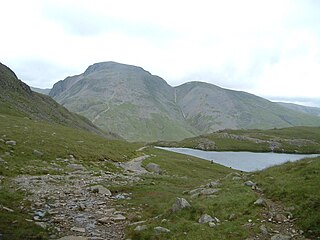
Great Gable is a mountain in the Lake District, United Kingdom. It is named after its appearance as a pyramid from Wasdale, though it is dome-shaped from most other directions. It is one of the most popular of the Lakeland fells, and there are many different routes to the summit. Great Gable is linked by the high pass of Windy Gap to its smaller sister hill, Green Gable, and by the lower pass of Beck Head to its western neighbour, Kirk Fell.

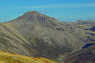
Bowfell is a pyramid-shaped mountain lying at the heart of the English Lake District, in the Southern Fells area. It is the sixth-highest mountain in the Lake District and one of the most popular of the Lake District fells for walkers. It is listed in Alfred Wainwright's 'best half dozen' Lake District fells.

Great End is the most northerly mountain in the Scafell chain, in the English Lake District. From the south it is simply a lump continuing this chain. From the north, however, it appears as an immense mountain, with an imposing north face rising above Sprinkling Tarn (lake). This is a popular location for wild camping, and the north face attracts many climbers.

Harter Fell is a fell in the western part of the English Lake District, located between the Eskdale and Duddon valleys. Its height is 653 metres (2,142 ft) There are several walking routes to the summit.

Borrowdale is a valley and civil parish in the English Lake District in Cumberland, England. It is in the ceremonial county of Cumbria, and is sometimes referred to as Cumberland Borrowdale to distinguish it from another Borrowdale in the historic county of Westmorland.

Esk Pike is a fell in the English Lake District, one of the cirque of hills forming the head of Eskdale.

Stybarrow Dodd is a mountain or fell in the English Lake District. It stands immediately north of Sticks Pass on the main ridge of the Helvellyn range in the Eastern Fells, which is situated between the lakes of Thirlmere and the Ullswater.
Red Screes is a fell in the English Lake District, situated between the villages of Patterdale and Ambleside. It may be considered an outlier of the Fairfield group in the Eastern Fells, but is separated from its neighbours by low cols. This gives Red Screes an independence which is reflected in its prominence.

Base Brown is a fell in England's Lake District, near the head of the Borrowdale Valley. It forms one side of the Seathwaite Valley, and on the western side it is flanked by the hanging valley of Gillercomb.
Seathwaite Fell is an area of the Lake District in Cumbria, England. It stands above the hamlet of the same name at the head of Borrowdale.

Glaramara is a fell in the English Lake District in Cumbria. It is a substantial fell that is part of a long ridge that stretches for over six kilometres from Stonethwaite in Borrowdale up to the important mountain pass of Esk Hause. The summit of Glaramara at 783 metres (2,569 ft) is the central point of this ridge, which separates the valleys of Langstrath and Grains Gill. However, the ridge has two additional fells, numerous subsidiary tops and several small tarns making its traverse an appealing and challenging walk.
Green Gable is a fell in the English Lake District often traversed by walkers en route to its more famous neighbour Great Gable. It can be ascended from Honister Pass, Seathwaite in Borrowdale, or Ennerdale. There are good views of Gable Crag, Scafell Pike and the Buttermere valley from the summit.

Sergeant's Crag is a fell in the English Lake District. It is an intermediate height on the ridge between the Langstrath and Greenup valleys in the Central Fells.

Grey Knotts is a fell in the English Lake District. It is situated one kilometre south of the B5289 road as it crosses the Honister Pass. It is well seen from mid-Borrowdale as it rises above Seatoller. Grey Knotts reaches a height of 697 metres and is part of a ridge which ascends from the woodland behind Seatoller and continues south-west and then south for four kilometres to Great Gable. The fell's name really only applies to the summit rocks, but has been adopted for the entire fell with the high ground in this area, locally known as Seatoller Fell on Ordnance Survey maps.

Calf Crag is a fell in the English Lake District, on the eastern side of the High Raise massif.
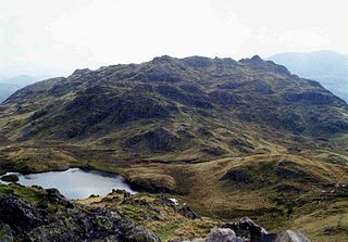
Rosthwaite Fell is a fell in the English Lake District. It is situated some 12 kilometres due south of Keswick and 2 kilometres south of the village of Rosthwaite in Borrowdale.

Rossett Pike is a fell in the English Lake District. It is located at the head of Mickleden, one of two tributary valleys of Great Langdale.

The Southern Fells are a part of the Cumbrian Mountains in the Lake District of England. Including Scafell Pike, the highest peak in England, they occupy a broad area to the south of Great Langdale, Borrowdale and Wasdale. High and rocky towards the centre of the Lake District, the Southern Fells progressively take on a moorland character toward the south-west. In the south-east are the well-known Furness Fells, their heavily quarried flanks rising above Coniston Water.


