Swirl How

Last updated

Swirl How
Swirl how.jpg
Swirl How from Great Carrs
Highest point
Elevation 802.42 [1]  m (2,632.6 ft)
Prominence c. 112 m (disputed)
Listing Wainwright, Hewitt, Nuttall
Coordinates 54°23′44″N3°07′16″W / 54.39566°N 3.12123°W / 54.39566; -3.12123
Geography
Lake District National Park UK relief location map.png
Red triangle with thick white border.svg
Swirl How
Location in Lake District, UK
Location Cumbria, England (traditionally Lancashire)
Parent range Lake District, Southern Fells
OS grid NY273006
Topo map OS Landranger 97, Explorer OL6

Swirl How is a fell in the English Lake District. It stands between Coniston and the Duddon Valley in the southern part of the District. It rivals the Old Man of Coniston as the highest point within the traditional County Palatine of Lancashire [2] (it has been administered since 1974 by Cumbria County Council for local government purposes).

Contents

The Coniston (or Furness) Fells form the watershed between Coniston Water and the Duddon valley to the west. The range begins at Wrynose Pass and runs south for around 10 miles (16 km) before petering out at Broughton in Furness on the Duddon Estuary. Alfred Wainwright in his influential Pictorial Guide to the Lakeland Fells took only the northern half of the range as Lakeland proper, consigning the lower fells to the south to a supplementary work The Outlying Fells of Lakeland. Swirl How being a significant high point of the Coniston Fells therefore qualifies as one of the 214 Wainwrights. Later guidebook writers have chosen to include the whole range in their main volumes. [3] [4]

Height

A detailed survey on 24 May 2018 [1] measured the height of Swirl How to be 802.42 metres (2,632 ft 7 in).

The same survey also measured the height of nearby The Old Man of Coniston and found the highest visible natural ground to be also 802.42 metres (2,632 ft 7 in). The height of the ground on the summit plinth (man-made ground) is 803.53 metres (2,636 ft 3 in). The measurements were reported with a measurement uncertainty of plus or minus 0.05 metres (2 in).

The surveyors state: "if one considers the area covered by the plinth on Coniston Old Man and the observation that the highest rock is probably covered by it then we believe the evidence strongly suggests there is higher ground beneath it and that, therefore, Coniston Old Man should retain its current status" [as being the highest of the Furness Fells and the historic county top of Lancashire].

As of 2020, Ordnance Survey maps show The Old Man of Coniston with a height of 803m, and Swirl How at 802m.

Whichever of the two is the higher is the highest point in the historic County Palatine of Lancashire and is the highest point in the Furness Fells, and the twelfth most prominent mountain in England. [5]

Topography

Swirl How sends out ridges to the four points of the compass, each leading to further fells. Consequently, it also feeds the headwaters of four valleys.

The ridge northward to Great Carrs is named Top of Broad Slack, Broad Slack being a ferociously steep grass slope climbing out of the Greenburn valley between neighbouring crags. The ridge is a grassy plateau with a pronounced downward tilt to the west. The eastern edge is precipitous, curving around the head of Greenburn. On the journey to Great Carrs the path passes a memorial. This is the site of a wartime aircrash and bears the sad remains of a Royal Canadian Air Force Handley Page Halifax bomber. The undercarriage, together with a wooden cross and memorial cairn lies on the top of the ridge with the rest of the wreckage spread down Broad Slack. In his guidebook The Southern Fells Alfred Wainwright suggests that the plane approached from the west, failed to clear the ridge and tumbled down the other side. In fact, the wrecked aircraft came to rest on the western slope; the majority of the wreckage was subsequently pushed over the edge of broad slack by the RAF salvage crew, in order to make it less prominent and reduce the likelihood of overflying pilots spotting the wreckage and repeatedly reporting the crash. An engine and propeller from the aircraft are preserved at the Ruskin Museum in Coniston. [3] [4] [6] The tilted plateau of the north ridge is triangular in plan, narrowing to a point at Fairfield in the west. This is the col between Swirl How and the ridge's western outlier, Grey Friar. To the north of this ridge are long slopes leading down to the Duddon at Wrynose Bottom.

The main ridge continues southward, stepping down Great and Little How Crags to the depression of Levers Hawse. From here it rises again to Brim Fell with Dow Crag and The Old Man Of Coniston beyond. To the west of the Hawse is the valley of Tarn Head Beck, the main feeder of Seathwaite Tarn, a reservoir in a side valley of the Duddon system. This was originally a much smaller waterbody, but was dammed early in the 20th century to provide drinking water for the Barrow-in-Furness area. The dam is almost 400 yards (370 m) long and is concrete cored with slate buttresses, the resulting depth of the tarn being around 80 feet (24 m). Water is not abstracted directly from the tarn, but flows some distance downriver to an off-take weir. [7] To the east of Levers Hawse is Levers Water. This smaller tarn has also been raised by damming, but in this case the original user was the Coniston Copper Mines. Following the decline of mining in the late 19th century a water treatment plant was eventually built and the tarn now supplies drinking water for Coniston village.

The eastern arm of Swirl How leads down the stony slope of Prison Band to the depression at Swirl Hawse. From here it rises over the subsidiary top of Black Sails to the main summit of Wetherlam. Swirl Hawse Beck runs south from this ridge to feed Levers Water, whilst to the north of Wetherlam is Greenburn.

Geology

The summit ridge exposes welded rhyolitic tuff and lapilli-tuff of the Long Top Member, interspersed with bands of andesitic lapilli tuff of the Wetside Edge Member. [8]

Summit

The summit of Swirl How is marked by a fine cairn on a stony top, built close to the Greenburn edge of the ridge. The view to the north takes in massed ranks of fells while in other directions the Isle of Man, Morecambe Bay and Pennines can be seen. [6]

Ascents

Direct ascents can be made via Levers Hawse to the south or Swirl Hawse to the east. Both can be gained from Coniston and Swirl Hawse is also a practicable objective from Little Langdale. The right of way shown up the western (Duddon) side of Levers Hawse does not exist as a path on the ground. Many walkers will arrive on Swirl How via one of the surrounding fells, all four ridges carrying fair paths. [3]

Name

The origin of the name Swirl How is obscure. A Norwegian dialect word svirle meaning to swirl or whirl around, suggests that there may have been an Old Norse origin. How is believed to derive from the Old Norse word haugr meaning hill or mound. [9]

Related Research Articles

<span class="mw-page-title-main">Old Man of Coniston</span> Mountain in the English Lake District, Cumbria, England

The Old Man of Coniston is a fell in the Furness Fells of the Lake District in Cumbria, England, and is the highest point of the historic county of Lancashire. It is at least 2,632.62 feet (802.42 m) high, and lies to the west of the village of Coniston and the lake, Coniston Water. The fell is sometimes known by the alternative name of Coniston Old Man, or simply The Old Man. The mountain is popular with tourists and fell-walkers with a number of well-marked paths to the summit. The mountain has also seen extensive copper and slate mining activity for eight hundred years, and the remains of abandoned mines and spoil tips are a significant feature of the north-east slopes.
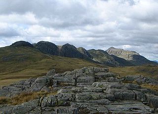
<span class="mw-page-title-main">Cold Pike</span> Fell in the Lake District, Cumbria, England

Cold Pike is a fell in the English Lake District. It is a satellite of Crinkle Crags and stands above the Upper Duddon Valley.

<span class="mw-page-title-main">Holme Fell</span> Fell in Cumbria, England

Holme Fell or Holm Fell is a fell in the Lake District in Cumbria, England. It is located between Coniston Water and Little Langdale, almost isolated from the neighbouring Coniston Fells by Yewdale Beck.

<span class="mw-page-title-main">Pike of Blisco</span> Mountain in the English Lake District, Cumbria, England

Pike of Blisco, or Pike o' Blisco, is a mountain in the Lake District in Cumbria, England. Located between the valleys of Great Langdale and Little Langdale, its relative isolation from neighbouring fells together with slopes falling away immediately from the summit in all directions mean it has excellent views: the view of the Langdale Pikes across Great Langdale is particularly arresting.

<span class="mw-page-title-main">Furness Fells</span>

<span class="mw-page-title-main">Seathwaite Fell</span> Fell in the Lake District, Cumbria, England

Seathwaite Fell is an area of the Lake District in Cumbria, England. It stands above the hamlet of the same name at the head of Borrowdale.

<span class="mw-page-title-main">Devoke Water</span> Lake in Cumbria, England

Devoke Water is a small lake in the south west of the Lake District in North West England. It is the largest tarn in the Lake District, a tarn being a specific type of glacial lake formed when a hollow is created on a mountain. The lake is 1.17 kilometres (0.73 mi) long, has an area of 0.34 square kilometres (0.13 sq mi) and lies at an altitude of 236 metres (774 ft) on Birker Fell. Its outflow, to the north west, is Linbeck Gill, which joins the River Esk before flowing into the Irish Sea at Ravenglass. The lake is in the unitary authority of Cumberland and the ceremonial county of Cumbria. Its south-western shore forms part of the south-western boundary of Eskdale parish, in which it is situated.

<span class="mw-page-title-main">Dow Crag</span> Fell in the Lake District, Cumbria, England

Dow Crag is a fell in the English Lake District near Coniston, Cumbria. The eastern face is one of the many rock faces in the Lake District used for rock climbing.

<span class="mw-page-title-main">Stickle Pike</span> Mountain in the English Lake District, Cumbria, England

Stickle Pike is an outlying fell located in the southern Lake District near the small town of Broughton-in-Furness, with the summit situated between the lower Duddon Valley and the quiet smaller valley of Dunnerdale. Despite its low altitude the sharp, conical summit is prominent in views from the Broughton and high Furness areas. As with many of the Dunnerdale and Coniston fells, there are reminders of the area's former mining past in the form of many spoil heaps, disused levels and shafts. The fell is also notable for its wide-ranging views despite its low altitude, especially to the Scafells to the north and the sands of the Duddon Estuary to the south. A "stickle" is a hill with a prominent rocky top.

<span class="mw-page-title-main">Grey Friar</span> Fell in the Lake District, Cumbria, England

Grey Friar is a fell in the English Lake District, it is one of the Coniston Fells and is situated 13 kilometres west-south-west of Ambleside. It reaches a height of 770 metres and stands to the north west of the other Coniston Fells, a little off the beaten track and tends to be the least visited of the group. It is quite a large fell and forms the eastern wall of the Duddon Valley for several kilometres, in fact all drainage from Grey Friar goes to the Duddon Valley and not to Coniston Water.

<span class="mw-page-title-main">Muncaster Fell</span> Mountain in the English Lake District, Cumbria, England

Muncaster Fell is a fell at the far western edge of the Lake District National Park, in Cumbria, England. Muncaster Fell is a long, narrow ridge of land, approximately 1.2 km wide and 6 km long, lying between the River Mite to the north, and River Esk to the south. The fell rises from the coast near Ravenglass village to its highest point at Hooker Crag (231 m). The ridge then continues to the north-east, dropping gently to its furthest prominence at Silver Knott (174 m). The fell then falls away rapidly to the village of Eskdale Green at its north-eastern tip.

<span class="mw-page-title-main">Wetherlam</span> Mountain in the English Lake District, Cumbria, England

Wetherlam is a mountain in the English Lake District. It is the most northerly of the Coniston Fells, the range of fells to the north-west of Coniston village; its north-east slopes descend to Little Langdale.

<span class="mw-page-title-main">Black Fell (Lake District)</span> Fell in the Lake District, United Kingdom

Black Fell is a fell in the English Lake District. It rises to the north of Tarn Hows, between Coniston and Hawkshead.

<span class="mw-page-title-main">Brim Fell</span> Fell in the Lake District, Cumbria, England

Brim Fell is a fell in the English Lake District. It stands to the west of Coniston village in the southern part of the District.

<span class="mw-page-title-main">Great Carrs</span> Fell in the Lake District, Cumbria, England

Great Carrs is a fell in the English Lake District. It stands above Wrynose Pass in the southern part of the District.

<span class="mw-page-title-main">Southern Fells</span>

<span class="mw-page-title-main">Caw (hill)</span> Hill in Cumbria, England

Caw is a hill in Cumbria, England, near the village of Seathwaite above the Duddon Valley, reaching 1,735 feet (529 m) and having a trig point at the summit. It is the subject of a chapter of Wainwright's book The Outlying Fells of Lakeland. His anticlockwise route from Seathwaite returns over Pikes at 1,520 feet (460 m) and Green Pikes at 1,350 feet (410 m).

<span class="mw-page-title-main">Great Worm Crag</span> Hill in English Lake District

Great Worm Crag is a hill in south west of the English Lake District, north of Ulpha, Cumbria. It is the subject of a chapter of Wainwright's book The Outlying Fells of Lakeland. It reaches a height of 1,400 feet (430 m) and Wainwright's route is a clockwise circuit from the fell road between Ulpha and Eskdale Green. Mark Richards in his Fellrangers book series describes it as "A lovely place to roam ... blessed with spacious views" and offers two ascent routes from the south west and one, via Birkerthwaite, from the north west.

<span class="mw-page-title-main">Levers Water</span>

Levers Water is a small lake in the English Lake District. It is located at the head of the Coppermines Valley, above Coniston village. To its south-west is Raven Tor, a spur of Brim Fell, and to its north-west are Little How Crags and Great How Crags, on the eastern side of the north–south ridge leading to Swirl How.

<span class="mw-page-title-main">Wallowbarrow Crag</span> Hill in Cumbria, England

Wallowbarrow Crag is a hill of 292 metres (958 ft) in the Lake District, England. It is on the west of the Duddon Valley, across the valley from the village of Seathwaite.

References

  1. 1 2 Barnard, John; Bloomer, Jim; Graham, Jackson (24 May 2018). "Surveys of Swirl How and Coniston Old Man" (PDF). hill-bagging.co.uk. Retrieved 18 May 2021.
  2. County Palatine of Lancashire (Friends of Real Lancashire), http://www.forl.co.uk/online-resources/lancashire-county-palatine
  3. 1 2 3 Richards, Mark: Southern Fells: Collins (2003): ISBN   0-00-711367-6
  4. 1 2 Birkett, Bill: Complete Lakeland Fells: Collins Willow (1994): ISBN   0-00-218406-0
  5. Dawson, Alan; Carey, Richard L. (7 September 2007). "England - Top 50 Prominent Peaks". peakbagging.com. Retrieved 17 May 2021.
  6. 1 2 Alfred Wainwright: A Pictorial Guide to the Lakeland Fells , Book 4: ISBN   0-7112-2457-9
  7. Blair, Don: Exploring Lakeland Tarns: Lakeland Manor Press (2003): ISBN   0-9543904-1-5
  8. British Geological Survey: 1:50,000 series maps, England & Wales Sheet 38: BGS (1998)
  9. "Place Names of the Lake District Fells". ukonline.co.uk. Archived from the original on 18 July 2006. Retrieved 18 May 2021.