Cold Pike

Last updated
Cold Pike
Cold Pike from Great Knott.jpg
Cold Pike from Great Knott
Highest point
Elevation 701 m (2,300 ft)
Prominence c. 46 m
Parent peak Crinkle Crags
Listing Hewitt, Nuttall, Wainwright
Coordinates 54°25′16″N3°08′02″W / 54.421°N 3.134°W / 54.421; -3.134 Coordinates: 54°25′16″N3°08′02″W / 54.421°N 3.134°W / 54.421; -3.134
Geography
Lake District National Park UK relief location map.png
Red triangle with thick white border.svg
Cold Pike
Location in the Lake District
Location relief map Borough of Copeland.svg
Red triangle with thick white border.svg
Cold Pike
Location in Copeland Borough
Location relief map United Kingdom South Lakeland.svg
Red triangle with thick white border.svg
Cold Pike
Location in South Lakeland
Location Cumbria, England
Parent range Lake District, Southern Fells
OS grid NY262035
Topo map OS Landranger 90, Explorer OL6
Listed summits of Cold Pike
NameGrid refHeightStatus
Cold Pike West Top NY258035 683 m (2,241 ft)Nuttall
Cold Pike Far West Top NY256037 670 m (2,198 ft)Nuttall

Cold Pike is a fell in the English Lake District. It is a satellite of Crinkle Crags and stands above the Upper Duddon Valley.

Contents

Topography

When travelling clockwise, Crinkle Crags is the last of the high cirque of fells forming the head of upper Eskdale. It sends out a trio of ridges to the south, running parallel like the prongs of a trident. Working from the west these ridges culminate in Hard Knott, Little Stand and Cold Pike. The Cold Pike ridge begins indistinctly in an area of rocky knolls and small tarns beneath the Fifth Crinkle. Gradually gaining definition it descends to a broad grassy saddle before rising again to the summit plateau of Cold Pike. To the north of the saddle is Great Knott (2,283 ft). This top is considered by most guidebooks to be a subsidiary of Crinkle Crags rather than the nearer Cold Pike. [1] [2] Beyond the summit the ridge continues for another half mile south eastward before falling steeply over the many tiered crags of Wrynose Breast.

Wrynose Breast stands above the nascent Duddon and the Wrynose Pass road, which provides the only vehicular link between central Lakeland and the Duddon Valley. Together with Hardknott Pass to the west, Wrynose is the latest incarnation of the Roman road from Ambleside to the port of Ravenglass.

To the west of Cold Pike is the Gaitscale Beck, the watercourse separating it from Little Stand. To the east across a wide low col is Pike of Blisco, a conical fell with its footing firmly in Langdale. The source of the River Duddon flows south from this col, curving westward around the foot of Wrynose Breast. To the north is Red Tarn, a feeder via Oxendale of Great Langdale Beck. Red Tarn is an elongated pool whose stony bed can be seen through clear shallow waters, reputed to hold trout. [3] It forms a focal point for walkers as the wide path from the summit of Wrynose Pass down to Stool End runs beside it, a further path branching off across the outflow to Crinkle Crags.

Geology

The fell top is composed of dacite lava flows with the volcaniclastic sandstones and tuffs of the Blisco Member outcropping to the south. [4]

The main Red Tarn path was originally made to serve Red Crag Mine. This consists of a series of pits and trial borings for iron, concentrated about 300 yards north of the tarn. It was worked from 1860 to 1875 but never achieved commercial success. [5]

Summit

The summit plateau of Cold Pike has three widely separated summits, all of which are listed as nuttalls. The lower two are unnamed on Ordnance Survey maps, but are generally referred to as Cold Pike West Top and Cold Pike Far West Top. [6] The true summit is itself one of a series of three outcrops in a mild echoing of Crinkle Crags. Each has a cairn, the highest being a fine example. The top is an excellent place from which to survey Crinkle Crags, the Langdale Pikes, and the northern end of the Coniston Fells across Wrynose Bottom; there is a fine distant prospect of the Pennines above Windermere, and Morecambe Bay above the Duddon Valley. [1] [2]

Ascents

Cold Pike can be reached easily via Red Tarn from the carpark at the summit of Wrynose Pass. It can also be climbed (less easily) from Great Langdale. More ‘honest’ walkers beginning in the south may wish to start from Little Langdale or Wrynose Bottom, first ascending Wrynose Pass. A direct route from Wrynose Bottom is also possible although pathless, skirting around the left of the crags. A consideration here is that the Duddon will need to be forded when starting out. [2] Cold Pike is often seen as a worthwhile detour en route to Crinkle Crags.

Related Research Articles

Pillar (Lake District)

Pillar is a mountain in the western part of the English Lake District. Situated between the valleys of Ennerdale to the north and Wasdale to the south, it is the highest point of the Pillar group. At 892 metres (2,927 feet) it is the eighth-highest mountain in the Lake District. The fell takes its name from Pillar Rock, a prominent feature on the Ennerdale side, regarded as the birthplace of rock climbing in the district.

Bowfell

Bowfell is a pyramid-shaped mountain lying at the heart of the English Lake District, in the Southern Fells area. It is the sixth-highest mountain in the Lake District and one of the most popular of the Lake District fells for walkers. It is listed in Alfred Wainwright's 'best half dozen' Lake District fells.

Crinkle Crags

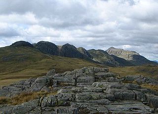
Crinkle Crags is a fell in the English Lake District in the county of Cumbria. It forms part of two major rings of mountains, surrounding the valleys of Great Langdale and Upper Eskdale. The name reflects the fell's physical appearance as its summit ridge is a series of five rises and depressions (crinkles) that are very distinctive from the valley floor. In Old English, cringol means twisted or wrinkled.

Hard Knott Fell in the Lake District, Cumbria, England

Hard Knott is a fell in the English Lake District, at the head of Eskdale.

Harter Fell (Eskdale) Fell in the Lake District, Cumbria, England

Harter Fell is a fell in the western part of the English Lake District, located between the Eskdale and Duddon valleys. Its height is 649 m (2128 ft). There are several walking routes to the summit.

High Raise (Langdale)

High Raise is a fell in the Central Fells of the English Lake District, not to be confused with another High Raise situated in the Far Eastern Fells. High Raise is not one of the most spectacular mountains in the district; however, with a height of 762 metres (2,500 ft) it is the highest point in the central fells of Lakeland.

Esk Pike Fell in the Lake District, Cumbria, England

Esk Pike is a fell in the English Lake District, one of the great cirque of hills forming the head of Eskdale.

Great Langdale

Great Langdale is a valley in the Lake District National Park in North West England, the epithet Great distinguishing it from the neighbouring valley of Little Langdale. Langdale is also the name of a valley in the Howgill Fells, elsewhere in Cumbria.

Pike of Stickle

Pike of Stickle, also known as Pike o’ Stickle, is a fell in the English Lake District. It reaches a height of 709 metres (2,326 feet) and is situated in the central part of the national park in the valley of Great Langdale. The fell is one of three fells which make up the picturesque Langdale Pikes, one of the best-known areas in Lakeland. A "stickle" is a hill with a steep prominent rocky top, while a "pike" is a hill with a peaked summit, the name being therefore partly tautological.

Pike of Blisco

Pike of Blisco, or Pike o' Blisco, is a mountain in the Lake District in Cumbria, England. Located between the valleys of Great Langdale and Little Langdale, its relative isolation from neighbouring fells together with slopes falling away immediately from the summit in all directions mean it has excellent views: the view of the Langdale Pikes across Great Langdale is particularly arresting.

Harrison Stickle

Harrison Stickle is a fell in the central part of the English Lake District, situated above Great Langdale. The fell is one of the three fells which make up the picturesque Langdale Pikes, the others being Pike of Stickle and Loft Crag. Together they make up one of the most picturesque, and probably the best-known, mountain groups in the District. A "stickle" is a hill with a prominent rocky top.

Dow Crag Fell in the Lake District, Cumbria, England

Dow Crag is a fell in the English Lake District near Coniston, Cumbria. The eastern face is one of the many rock faces in the Lake District used for rock climbing.

Calf Crag

Calf Crag is a fell in the English Lake District, on the eastern side of the High Raise massif.

Grey Friar Fell in the Lake District, Cumbria, England

Grey Friar is a fell in the English Lake District, it is one of the Coniston Fells and is situated 13 kilometres west-south-west of Ambleside. It reaches a height of 770 metres and stands to the north west of the other Coniston Fells, a little off the beaten track and tends to be the least visited of the group. It is quite a large fell and forms the eastern wall of the Duddon Valley for several kilometres, in fact all drainage from Grey Friar goes to the Duddon Valley and not to Coniston Water.

Stone Arthur

Stone Arthur is a fell in the English Lake District, an outlier of the Fairfield group in the Eastern Fells. It stands above Grasmere village.

Rossett Pike

Rossett Pike is a fell in the English Lake District. It is located at the head of Mickleden, one of two tributary valleys of Great Langdale.

Great Carrs Fell in the Lake District, Cumbria, England

Great Carrs is a fell in the English Lake District. It stands above Wrynose Pass in the southern part of the District.

Green Crag

Green Crag is a fell in the English Lake District. It stands between Eskdale and the Duddon valley in the Southern Fells.

The Central Fells are a group of hills in the English Lake District. Reaching their highest point at High Raise, they occupy a broad area to the east of Borrowdale. Perhaps unexpectedly the Central Fells are generally lower than the surrounding hills, the Lake District's general dome-like structure having a slight dip in the middle. The range extends from the boggy ridge between Derwentwater and Thirlmere in the north, to the famous rock peaks of the Langdale Pikes in the south.

Southern Fells

The Southern Fells are a group of hills in the English Lake District. Including Scafell Pike, the highest peak in England, they occupy a broad area to the south of Great Langdale, Borrowdale and Wasdale. High and rocky towards the centre of the Lake District, the Southern Fells progressively take on a moorland character toward the south west. In the south east are the well known Furness Fells, their heavily quarried flanks rising above Coniston Water.

References

  1. 1 2 Alfred Wainwright: A Pictorial Guide to the Lakeland Fells , Book 4: ISBN   0-7112-2457-9
  2. 1 2 3 Richards, Mark: Mid-Western Fells: Collins (2004): ISBN   0-00-711368-4
  3. Blair, Don: Exploring Lakeland Tarns: Lakeland Manor Press (2003): ISBN   0-9543904-1-5
  4. British Geological Survey: 1:50,000 series maps, England & Wales Sheet 38: BGS (1998)
  5. Adams, John: Mines of the Lake District Fells: Dalesman (1995) ISBN   0-85206-931-6
  6. Nuttall, John & Anne: The Mountains of England & Wales - Volume 2: England (2nd edition): Cicerone (1990): ISBN   1-85284-037-4