Great Carrs

Last updated

Great Carrs
Great carrs from cold pike.jpg
Great Carrs (centre) from Cold Pike. Swirl How is on the left and the summit of Brim Fell is seen just to the right of Great Carrs.
Highest point
Elevation 788 m (2,585 ft)
Prominence c. 20 m
Parent peak Swirl How
Listing Wainwright, Nuttall
Coordinates 54°23′54″N3°07′28″W / 54.39833°N 3.12438°W / 54.39833; -3.12438
Geography
Lake District National Park UK relief location map.png
Red triangle with thick white border.svg
Great Carrs
Location in Lake District, UK
Location Cumbria, England
Parent range Lake District, Southern Fells
OS grid NY271009
Topo map OS Landranger 89,90, Explorer OL6

Great Carrs is a fell in the English Lake District. It stands above Wrynose Pass in the southern part of the District.

Contents

Topography

The Coniston (or Furness) Fells form the watershed between Coniston Water and the Duddon valley to the west. The range begins at Wrynose Pass and runs south for around 10 miles (16 km) before petering out at Broughton in Furness on the Duddon Estuary. Alfred Wainwright in his influential Pictorial Guide to the Lakeland Fells took only the northern half of the range as Lakeland proper, consigning the lower fells to the south to a supplementary work The Outlying Fells of Lakeland. Great Carrs being the most northerly of the Coniston Fells therefore qualifies as one of the 214 Wainwrights. Later guidebook writers have chosen to include the whole range in their main volumes. [1] [2]

Swirl How stands at the geographical centre of the Coniston Fells and, according to some sources, may be the highest of the group. A long sickle shaped ridge extends from the summit of Swirl How, first north and then curving around to the east. Great Carrs is the high point of this ridge, which continues as Wet Side Edge, falling to the floor of Little Langdale. A western outlier branching off the main ridge between Great Carrs and Swirl How is Grey Friar.

Great Carrs, in common with many fells, has easy slopes to the west and crags to the east. These crags- falling directly from the summit- form the head of Greenburn. A steep sided, rather marshy valley, Greenburn is a part of the Little Langdale system, its waters joining the River Brathay at Little Langdale Tarn. Greenburn itself bears a tarn, or more correctly the remains of a reservoir. A natural waterbody was dammed in the early 18th century to provide water for the Greenburn Mine. The 250-yard (230 m) long barrage has now been breached to leave a collection of pools and bogs. [3] The mines in question, also known as New Coniston Mine, were worked for copper from 1845 until substantially abandoned in 1865, the shafts reaching a depth of 700 ft below ground. [4] Greenburn is bounded to the north by the curve of Wet Side Edge and to the south by Wetherlam.

Wet Side Edge has a number of intermediate tops including Little Carrs (2,270 feet, 690 m), Hell Gill Pike (2,172 feet, 662 m) and Rough Crags (1,600 feet, 490 m). To the north of the ridge is Wrynose Pass, the only connection for vehicles between Langdale and the Duddon Valley, and the route of a Roman road. Across the pass are Cold Pike and Pike of Blisco, and behind them the ground rises toward the Scafells. The top of the pass at (1,290 feet, 390 m), although facilitating access from east to west, does not sit on any obvious ridge descending from Great Carrs.

To the west of Great Carrs long slopes fall to the head of the Duddon valley as the river begins its long journey from Wrynose to the Duddon Sands. There are isolated features such as Mart Crag and the deep gully of Hell Gill, but these flanks are generally unfrequented.

Geology

The Wet Side Edge Member (andesitic lapilli-tuff) and Long Top Member (rhyolitic tuff) recur in faulted bands across the fell. [5]

Air crash

The ridge southward to Swirl How is named Top of Broad Slack, Broad Slack being a ferociously steep grass slope climbing out of Greenburn between the crags. This is the site of a wartime aircrash and bears the sad remains of a Royal Canadian Air Force Handley Page Halifax bomber. The undercarriage, together with a wooden cross and memorial cairn is on the top of the ridge with the rest of the wreckage spread down Broad Slack. During a night time navigation exercise in 1944, the RCAF Halifax from RAF Topcliffe in North Yorkshire became lost in thick cloud while over the north west of England. In an attempt to wait out the blanket of grey, they circled in hope the cloud would clear, ultimately becoming hopelessly lost. To try to get a visual fix for the navigator, the pilot dropped the bomber out of the cloud base, with no knowledge of what was below him. Unfortunately, for both him, the crew and the aircraft, they were greeted by the great rising fells of Swirl How and Great Carrs. With no time to react, the aircraft hit the mountainside killing all on board. Despite the crew perishing in the impact, the bomber remained largely intact and, to prevent other aircraft from spotting it and reporting it repeatedly, the wreckage was cut into a number of smaller, moveable pieces and discarded down Broad Slack, where parts of it are still visible today. Over the years, two of the four Rolls-Royce engines were recovered from the crash site by an RAF helicopter, one of which is now on display at the Ruskin Museum in Coniston. [1] [2] [6] In contrast to the craggy scarp of the east face, the western slope of the ridge descends over grass to the col of Fairfield, forming a tilted triangular plateau. Across Fairfield is the rocky top of Grey Friar.

Summit

The summit of Great Carrs is marked by a small cairn on grass, perched above the rocky abyss of the head of Greenburn. The view to the north takes in serried ranks of fells while in other directions the Isle of Man and Pennines can be seen. [1]

Ascents

Climbs from Little Langdale via Wet Side Edge provide the most popular direct route up Great Carrs. The Edge can also be gained near the top from the summit of Wrynose Pass. Pathless ascents via Hell Gill or Broad Slack are also possible, but many other walkers will arrive on Great Carrs from Swirl How or Grey Friar. [1]

Related Research Articles

<span class="mw-page-title-main">Old Man of Coniston</span> Mountain in the English Lake District, Cumbria, England

The Old Man of Coniston is a fell in the Furness Fells of the Lake District in Cumbria, England, and is the highest point of the historic county of Lancashire. It is at least 2,632.62 feet (802.42 m) high, and lies to the west of the village of Coniston and the lake, Coniston Water. The fell is sometimes known by the alternative name of Coniston Old Man, or simply The Old Man. The mountain is popular with tourists and fell-walkers with a number of well-marked paths to the summit. The mountain has also seen extensive copper and slate mining activity for eight hundred years, and the remains of abandoned mines and spoil tips are a significant feature of the north-east slopes.

<span class="mw-page-title-main">Crinkle Crags</span> Mountain in the English Lake District, Cumbria, England

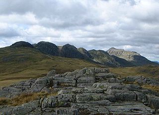
Crinkle Crags is a fell in the English Lake District in the county of Cumbria. It forms part of two major rings of mountains, surrounding the valleys of Great Langdale and Upper Eskdale. The name reflects the fell's physical appearance as its summit ridge is a series of five rises and depressions (crinkles) that are very distinctive from the valley floor. In Old English, cringol means twisted or wrinkled.

<span class="mw-page-title-main">Dale Head</span> Mountain in the Lake District, England

Dale Head is a fell in the north-western sector of the Lake District, in northern England. It is 753 metres or 2,470 foot above sea level and stands immediately north of Honister Pass, the road between Borrowdale and Buttermere.

<span class="mw-page-title-main">Cold Pike</span> Fell in the Lake District, Cumbria, England

Cold Pike is a fell in the English Lake District. It is a satellite of Crinkle Crags and stands above the Upper Duddon Valley.

<span class="mw-page-title-main">Holme Fell</span> Fell in Cumbria, England

Holme Fell or Holm Fell is a fell in the Lake District in Cumbria, England. It is located between Coniston Water and Little Langdale, almost isolated from the neighbouring Coniston Fells by Yewdale Beck.

<span class="mw-page-title-main">Pike o' Blisco</span> Mountain in the English Lake District, Cumbria, England

Pike o' Blisco, or Pike of Blisco, is a mountain in the Lake District in Cumbria, England. Located between the valleys of Great Langdale and Little Langdale, its relative isolation from neighbouring fells together with slopes falling away immediately from the summit in all directions mean it has excellent views: the view of the Langdale Pikes across Great Langdale is particularly arresting.

<span class="mw-page-title-main">Furness Fells</span>

The Furness Fells are a multitude of hills and mountains in the Furness region of Cumbria, England. Historically part of Lancashire, the Furness Fells or High Furness is the name given to the upland part of Furness, that is, that part of Furness lying north of the line between Ulverston and Ireleth. The hills lie largely within the English Lake District.

<span class="mw-page-title-main">Dow Crag</span> Fell in the Lake District, Cumbria, England

Dow Crag is a fell in the English Lake District near Coniston, Cumbria. The eastern face is one of the many rock faces in the Lake District used for rock climbing.

<span class="mw-page-title-main">Stickle Pike</span> Mountain in the English Lake District, Cumbria, England

Stickle Pike is an outlying fell located in the southern Lake District near the small town of Broughton-in-Furness, with the summit situated between the lower Duddon Valley and the quiet smaller valley of Dunnerdale. Despite its low altitude the sharp, conical summit is prominent in views from the Broughton and high Furness areas. As with many of the Dunnerdale and Coniston fells, there are reminders of the area's former mining past in the form of many spoil heaps, disused levels and shafts. The fell is also notable for its wide-ranging views despite its low altitude, especially to the Scafells to the north and the sands of the Duddon Estuary to the south. A "stickle" is a hill with a prominent rocky top.

<span class="mw-page-title-main">Green Gable</span> Mountain in the Lake District, England

Green Gable is a fell in the English Lake District often traversed by walkers en route to its more famous neighbour Great Gable. It can be ascended from Honister Pass, Seathwaite in Borrowdale, or Ennerdale. There are good views of Gable Crag, Scafell Pike and the Buttermere valley from the summit.

Blea Rigg is a fell in the English Lake District, lying between the valleys of Easedale and Great Langdale. One of the Central Fells, it is a broad plateau with a succession of rocky tops. Many routes of ascent are possible, beginning either from Grasmere or Great Langdale, though the paths are often poorly marked and hard to follow.

<span class="mw-page-title-main">Calf Crag</span> Fell in Cumbria, England

Calf Crag is a fell in the English Lake District, on the eastern side of the High Raise massif.

<span class="mw-page-title-main">Grey Friar</span> Fell in the Lake District, Cumbria, England

Grey Friar is a fell in the English Lake District, it is one of the Coniston Fells and is situated 13 kilometres west-south-west of Ambleside. It reaches a height of 770 metres and stands to the north west of the other Coniston Fells, a little off the beaten track and tends to be the least visited of the group. It is quite a large fell and forms the eastern wall of the Duddon Valley for several kilometres, in fact all drainage from Grey Friar goes to the Duddon Valley and not to Coniston Water.

<span class="mw-page-title-main">Wetherlam</span> Mountain in the English Lake District, Cumbria, England

Wetherlam is a mountain in the English Lake District. It is the most northerly of the Coniston Fells, the range of fells to the north-west of Coniston village; its north-east slopes descend to Little Langdale.

<span class="mw-page-title-main">Swirl How</span> Fell in the Lake District, Cumbria, England

Swirl How is a fell in the English Lake District. It stands between Coniston and the Duddon Valley in the southern part of the District. It rivals the Old Man of Coniston as the highest point within the traditional County Palatine of Lancashire.

<span class="mw-page-title-main">Black Fell (Lake District)</span> Fell in the Lake District, United Kingdom

Black Fell is a fell in the English Lake District. It rises to the north of Tarn Hows, between Coniston and Hawkshead.

<span class="mw-page-title-main">Brim Fell</span> Fell in the Lake District, Cumbria, England

Brim Fell is a fell in the English Lake District. It stands to the west of Coniston village in the southern part of the District.

The Central Fells are a part of the Cumbrian Mountains in the Lake District of England. Reaching their highest point at High Raise, they occupy a broad area to the east of Borrowdale. The Central Fells are generally lower than the surrounding hills, the Lake District's dome-like structure having a slight dip in the middle. The range extends from the boggy ridge between Derwentwater and Thirlmere in the north, to the rock peaks of the Langdale Pikes in the south.

<span class="mw-page-title-main">Southern Fells</span>

The Southern Fells are a part of the Cumbrian Mountains in the Lake District of England. Including Scafell Pike, the highest peak in England, they occupy a broad area to the south of Great Langdale, Borrowdale and Wasdale. High and rocky towards the centre of the Lake District, the Southern Fells progressively take on a moorland character toward the south-west. In the south-east are the well-known Furness Fells, their heavily quarried flanks rising above Coniston Water.

References

  1. 1 2 3 4 Richards, Mark: Southern Fells: Collins (2003): ISBN   0-00-711367-6
  2. 1 2 Birkett, Bill: Complete Lakeland Fells: Collins Willow (1994): ISBN   0-00-218406-0
  3. Blair, Don: Exploring Lakeland Tarns: Lakeland Manor Press (2003): ISBN   0-9543904-1-5
  4. Adams, John: Mines of the Lake District Fells: Dalesman (1995) ISBN   0-85206-931-6
  5. British Geological Survey: 1:50,000 series maps, England & Wales Sheet 38: BGS (1998)
  6. Alfred Wainwright: A Pictorial Guide to the Lakeland Fells , Book 4: ISBN   0-7112-2457-9