Almendral

Last updated
Almendral
Municipality
Spain Extremadura location map.svg
Red pog.svg
Almendral
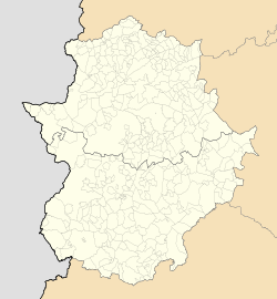
Location of Almendral within Extremadura
Coordinates: 38°36′51″N6°49′15″W / 38.61417°N 6.82083°W / 38.61417; -6.82083
Country Spain
Autonomous community Extremadura
Province Badajoz
Comarca Llanos de Olivenza
Area
  Total67 km2 (26 sq mi)
Population
 (2018) [1]
  Total1,240
  Density19/km2 (48/sq mi)
Time zone UTC+1 (CET)
  Summer (DST) UTC+2 (CEST)
Website http://almendral.dip-badajoz.es/

Almendral is a municipality located in the province of Badajoz, Extremadura, Spain. According to the 2004 census (INE), the municipality has a population of 1352 inhabitants.

Contents

History

From the earliest Iberian times, passing through the Celtic, Phoenician, Greek, Carthaginian, Roman, Visigoth and Arab periods, until the middle of the 13th century, Extremadura suffered violent invasions, accusations of displacement of its first inhabitants and successive conquests that led to A state of instability and skepticism that was to be projected into the character of its future inhabitants. In any case, the primitive character was profiling and acquiring strength and identity of its own over the centuries until it was possible to establish a regional idiosyncrasy that has led it to continue to the present day.

The prehistoric essence of Lower Extremadura is linked to the various events that have been reported since the first Mediterranean invasions. According to the discoveries of ancient vestiges, it is conjectured that Almendral was populated by primitive tribes of Iberian race, since the territory between this town and Barcarrota, counts on one of the majors concentrations of megalithic tombs [4] of the Province of Badajoz.

Possible seat since the Roman period, the Visigoths should have elevated it of superior category, since in its old site, place known like the hermitage of San Matías, have appeared a series of visigodas pieces of some archaeological value that are currently in the Museum Archaeological site of Badajoz and in the hermitage of Finibus Térrae.

The present Almendral was founded by the Arabs, two kilometers from the old site of the church of San Matías, since the previous settlement would have been devastated by Portuguese forces when they ventured into Extremadura after the battle of Aljubarrota .

In 1333, King Alfonso XI the Justiciero handed over the town of Almendral, with all its terms and rents, to Enrique Enríquez "el Mozo" , lord of Villalba de los Barros and Justice mayor of the King's House, who was the great-grandson of Fernando III the Saint, King of Castile and León .

Almendral was a village of Badajoz and was part of the Manor of Feria in the time of Gome Suárez de Figueroa . During the seventeenth century, like the other Extremadura populations near the Portuguese border, Almendral also suffered from the ups and downs of the clashes between the two nations.

To the end of Francoist Spain the locality constitutes constitutional municipality in the region of Extremadura . From 1834 was integrated in the Judicial Party of Olivenza . 1 In the census of 1842 it had 480 homes and 1,670 neighbors.

Related Research Articles

<span class="mw-page-title-main">Badajoz</span> Municipality in Extremadura, Spain

Badajoz is the capital of the Province of Badajoz in the autonomous community of Extremadura, Spain. It is situated close to the Portuguese border, on the left bank of the river Guadiana. The population in 2011 was 151,565.

<span class="mw-page-title-main">Extremadura</span> Autonomous community of Spain

Extremadura is a landlocked autonomous community of Spain. Its capital city is Mérida, and its largest city is Badajoz. Located in the central-western part of the Iberian Peninsula, it is crossed from east to west by the Tagus and Guadiana rivers. The autonomous community is formed by the two largest provinces of Spain: Cáceres and Badajoz. Extremadura is bordered by Portugal to the west and by the autonomous communities of Castile and León (north), Castilla–La Mancha (east), and Andalusia (south).

<span class="mw-page-title-main">Mérida, Spain</span> Municipality in Extremadura, Spain

Mérida is a city and municipality of Spain, part of the Province of Badajoz, and capital of the autonomous community of Extremadura. Located in the western-central part of the Iberian Peninsula at 217 metres above sea level, the city is crossed by the Guadiana and Albarregas rivers. The population was 60,119 in 2017.

<span class="mw-page-title-main">Province of Badajoz</span> Province of Spain

The province of Badajoz is a province of western Spain located in the autonomous community of Extremadura. It was formed in 1833. It is bordered by the provinces of Cáceres in the north, Toledo, Ciudad Real in the east, Córdoba in the south-east, Seville, and Huelva in the south and Portugal in the west.

<span class="mw-page-title-main">Cáceres, Spain</span> Municipality in Extremadura, Spain

Cáceres is a city of Spain located in the autonomous community of Extremadura. It is the capital and most populated municipality of the province of Cáceres.

<span class="mw-page-title-main">Alcántara</span> Municipality in Extremadura, Spain

Alcántara is a municipality in the province of Cáceres, Extremadura, Spain, on the Tagus, near Portugal. The toponym is from the Arabic word al-Qanṭarah (القنطرة) meaning "the bridge".

<span class="mw-page-title-main">Monsaraz</span> Civil parish in Alentejo, Portugal

Monsaraz is a civil parish (freguesia) of the municipality of Reguengos de Monsaraz, on the right margin of the Guadiana River in the Portuguese Alentejo region, near its border with Spain. The population in 2011 was 782, in an area of 88.29 km2.

<span class="mw-page-title-main">Idanha-a-Velha</span> Civil parish in Centro, Portugal

Idanha-a-Velha is a village in the civil parish (freguesia) of Monsanto e Idanha-a-Velha, in the municipality of Idanha-a-Nova, central eastern Portugal, and the site of ancient Egitânia, a former bishopric. It covers an area of 20.98 km2 and had a population of 79 as of 2001.

<span class="mw-page-title-main">Marvão</span> Municipality in Alentejo, Portugal

Marvão is a municipality in Portalegre District in Portugal. The population in 2020 was 2,972, in an area of 154.90 km2. The present Mayor is Luís Vitorino, elected by the Social Democratic Party. The municipal holiday is September 8.

<span class="mw-page-title-main">Coria, Cáceres</span> Municipality in Extremadura, Spain

Coria is a municipality of Spain belonging to the province of Cáceres, Extremadura. In addition to the town of the same name, the municipality also comprises the settlements of Puebla de Argeme and Rincón del Obispo. With a population of has 12,531 inhabitants, Coria is the fourth most-populated municipality in the province.

<span class="mw-page-title-main">Hornachos</span> Place in Extremadura, Spain

Hornachos is a municipality located in the province of Badajoz, Extremadura, Spain. According to the 2005 census (INE), the municipality has a population of 3,840 inhabitants.

<span class="mw-page-title-main">Torre de Miguel Sesmero</span> Place in Extremadura, Spain

Torre de Miguel Sesmero is a municipality located in the province of Badajoz, Extremadura, Spain (Europe).

<span class="mw-page-title-main">Villanueva del Fresno</span> Place in Extremadura, Spain

Villanueva del Fresno is a town in Badajoz Province in Extremadura, Spain.

<span class="mw-page-title-main">Montejo de Tiermes</span> Municipality in Castile and León, Spain

Montejo de Tiermes is a municipality located in the province of Soria, Castile and León, Spain. In 2010 the population of Montejo de Tiermes (municipality) was 198 inhabitants, 126 men and 72 women. Montejo de Tiermes (locality) had a population of 58 inhabitants on 1 January 2010, 41 men and 17 women.

<span class="mw-page-title-main">Portugal–Spain relations</span> Bilateral relations

Portugal and Spain enjoy a friendly relationship. They are both members of the Ibero-American Summit, Council of Europe, European Union, Eurozone, Schengen Area and NATO, and make up the vast majority of the Iberian Peninsula and Macaronesia.

<span class="mw-page-title-main">Hispania</span> Roman province (218 BC – 472 AD)

Hispania was the Roman name for the Iberian Peninsula. Under the Roman Republic, Hispania was divided into two provinces: Hispania Citerior and Hispania Ulterior. During the Principate, Hispania Ulterior was divided into two new provinces, Baetica and Lusitania, while Hispania Citerior was renamed Hispania Tarraconensis. Subsequently, the western part of Tarraconensis was split off, initially as Hispania Nova, which was later renamed "Callaecia". From Diocletian's Tetrarchy onwards, the south of the remainder of Tarraconensis was again split off as Carthaginensis, and all of the mainland Hispanic provinces, along with the Balearic Islands and the North African province of Mauretania Tingitana, were later grouped into a civil diocese headed by a vicarius. The name Hispania was also used in the period of Visigothic rule.

<span class="mw-page-title-main">Sierra Suroeste</span> Comarca in Extremadura, Spain

Sierra Suroeste is a comarca located in southwestern province of Badajoz in the autonomous community of Extremadura, western Spain. Its capital and largest city is Jerez de los Caballeros.

<span class="mw-page-title-main">Alcazaba of Badajoz</span>

The Alcazaba of Badajoz is an ancient Moorish citadel in Badajoz, Extremadura, western Spain. The alcazaba as it now appears was built by the Almohads in the 12th century, although it probably existed from the 9th century, when Badajoz was founded. In the 11th and 12th centuries it was the residence of the rulers of the taifa of Badajoz.

<span class="mw-page-title-main">Villar de Plasencia</span> Place in Extremadura, Spain

Villar de Plasencia is a municipality located in the province of Cáceres, in the autonomous community of Extremadura, Spain. The municipality covers an area of 24.99 square kilometres (9.65 sq mi) and as of 2011 has a population of 243 people.

<span class="mw-page-title-main">Castle of Ouguela</span> Building in Ouguela

The Castle of Ouguela is a medieval castle erected in the civil parish of São João Baptista, municipality of Campo Maior, in the Portuguese district of Portalegre.

References

  1. Municipal Register of Spain 2018. National Statistics Institute.


38°36′51″N6°49′15″W / 38.61417°N 6.82083°W / 38.61417; -6.82083