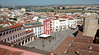
Badajoz is the capital of the Province of Badajoz in the autonomous community of Extremadura, Spain. It is situated close to the Portuguese border, on the left bank of the river Guadiana. The population in 2011 was 151,565.
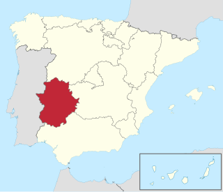
Extremadura is a landlocked autonomous community of Spain. Its capital city is Mérida, and its largest city is Badajoz. Located in the central-western part of the Iberian Peninsula, it is crossed from east to west by the Tagus and Guadiana rivers. The autonomous community is formed by the two largest provinces of Spain: Cáceres and Badajoz. Extremadura is bordered by Portugal to the west and by the autonomous communities of Castile and León (north), Castilla–La Mancha (east), and Andalusia (south).

The province of Badajoz is a province of western Spain located in the autonomous community of Extremadura. It was formed in 1833. It is bordered by the provinces of Cáceres in the north, Toledo, Ciudad Real in the east, Córdoba in the south-east, Seville, and Huelva in the south and Portugal in the west.
Azuaga is a town located in the province of Badajoz in southern Extremadura, bordering the Andalusian provinces of Seville and Córdoba in Spain. Azuga is 140 km from Badajoz, 125 km from Córdoba, and 140 km from Seville, in the foothills of Sierra Morena in the frontier region of Campiña Sur.
Villanueva de la Serena is a city in the Province of Badajoz, Extremadura, Spain. It has a population of 26,111 (2010) and forms part of a larger urban area with the neighbouring town of Don Benito.

La Serena is a comarca located in the east of the province of Badajoz, Extremadura, Spain. The main town is Castuera.
Zalamea de la Serena is a municipality in the province of Badajoz, Extremadura, Spain. According to the 2014 census, the municipality has a population of 3797 inhabitants.

Higuera de la Serena is a municipality in the province of Badajoz, Extremadura, Spain. It has a population of 943 and an area of 71.1 km2.
Valverde de Llerena is a municipality in the province of Badajoz, Extremadura, Spain. It has a population of 763 and an area of 41 km2.
Campillo de Llerena is a municipality located in the province of Badajoz, Extremadura, Spain. According to a 2005 census (INE), the municipality has a population of 1,624 inhabitants.
Higuera de Llerena is a municipality located in the province of Badajoz, Extremadura, Spain. According to the 2005 census (INE), the municipality has a population of 392 inhabitants.

Llerena is a municipality located in the province of Badajoz, Extremadura, Spain. According to the 2007 census (INE), the municipality had a population of 5,995 inhabitants. Llerena, a town that declared itself a Historical Artistic gathering on December 29, 1966, is located in southwestern Spain. The head of the judicial and economic center of the region of the country of the same name, it is equidistant from 20 municipalities, and sits at the confluence of the District 432 and 413 National Roads.
Llera is a Spanish municipality in the province of Badajoz, Extremadura, western Spain. According to the 2014 census, the municipality has a population of 905 inhabitants.

Campiña Sur is an administrative division (comarca) in the province of Badajoz, Extremadura, Spain. Its capital and administrative center is the municipality of Llerena. It contains 21 municipalities and 32,841 inhabitants in an area of 2,798 square kilometres (1,080 sq mi).

The battle of the Mérida pocket, also known as the closing of the Mérida pocket, was a military engagement which took place during the Spanish Civil War in July 1938 in La Serena zone of Badajoz Province, Extremadura.
Higuera, also known as Higuera de Albalat, is a Spanish municipality of the Province of Cáceres, in the autonomous community of Extremadura. The municipality covers an area of 40.54 square kilometres (15.65 sq mi) and as of 2011 had a population of 115 people.

The 109th Mixed Brigade, was a mixed brigade of the Spanish Republican Army in the Spanish Civil War. It was formed in the spring of 1937 in Utiel with four battalions, the 433, 434, 435 and 436.
