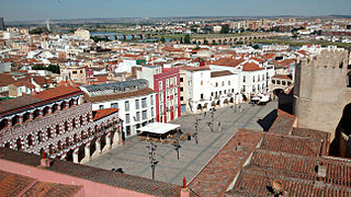
Badajoz is the capital of the Province of Badajoz in the autonomous community of Extremadura, Spain. It is situated close to the Portuguese border, on the left bank of the river Guadiana. The population in 2011 was 151,565.
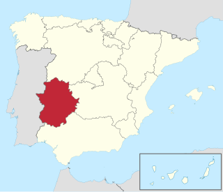
Extremadura is a landlocked autonomous community of Spain. Its capital city is Mérida, and its largest city is Badajoz. Located in the central-western part of the Iberian Peninsula, it is crossed from east to west by the Tagus and Guadiana rivers. The autonomous community is formed by the two largest provinces of Spain: Cáceres and Badajoz. Extremadura is bordered by Portugal to the west and by the autonomous communities of Castile and León (north), Castilla–La Mancha (east), and Andalusia (south).

The province of Ciudad Real is a province in the southwestern part of the autonomous community of Castile-La Mancha, Spain. It is bordered by the provinces of Cuenca, Albacete, Jaén, Córdoba, Badajoz, and Toledo. It is partly located in the old natural region of La Mancha. Its capital is Ciudad Real. It is the third largest province by area in all of Spain, after Cáceres and Badajoz. The historic comarca Campo de Calatrava is located in the center of the province.

The province of Badajoz is a province of western Spain located in the autonomous community of Extremadura. It was formed in 1833. It is bordered by the provinces of Cáceres in the north, Toledo, Ciudad Real in the east, Córdoba in the south-east, Seville, and Huelva in the south and Portugal in the west.
Azuaga is a town located in the province of Badajoz in southern Extremadura, bordering the Andalusian provinces of Seville and Córdoba in Spain. Azuga is 140 km from Badajoz, 125 km from Córdoba, and 140 km from Seville, in the foothills of Sierra Morena in the frontier region of Campiña Sur.

La Romana is a municipality and capital of the southeastern province of La Romana, opposite Catalina Island. It is one of the 10 largest cities in the Dominican Republic with a population estimated in 2022 at 153,241 within the city limits, of whom 149,840 are urban and 3,401 are rural. The name Romana comes from the word "Bomana", a name given by Indians to what is known today as Romana River.
Villanueva de la Serena is a city in the Province of Badajoz, Extremadura, Spain. It has a population of 26,111 (2010) and forms part of a larger urban area with the neighbouring town of Don Benito.
Don Benito is a Spanish town and municipality in the province of Badajoz, Extremadura, near the left bank of the Guadiana river. According to the 2014 census, the municipality has a population of 37,011.

The Casa de Campo is the largest public park in Madrid. It is situated west of central Madrid, Spain. It gets its name 'Country House' because it was once a royal hunting estate, located just west of the Royal Palace of Madrid. It was created in the early 16th century for use by the royal family and nobility, and was opened to the public in 1931 when it became a public park. Today, it is a popular green space and weekend destination for Madrid residents.

Pedro Muñoz is a municipality in the autonomous community of Castile-La Mancha, Spain. It is located in the northeast corner of the province of Ciudad Real, on the bank of the Záncara river. It is in the La Mancha region, in the "Mancha Alta" sub-region. It was founded in 1284 by the Archdeacon of Alcaraz, Pero Muñoz, as one of a series of defensible points in the La Mancha plains. The village was abandoned in 1410, due to a severe drought, and re-established in 1525. Since the late 19th century, Pedro Muñoz had been an important economic center in the region.

The Convento de San Marcos was a convent in the city of León, Castile and León, Spain, that is today an operating luxury parador hotel. It also contains a consecrated church and museum, and is one of the most important monuments of the Renaissance in Spain. It is one of the greatest architectural jewels of León, together with the Cathedral, the Basilica of San Isidoro and la Casa Botines. It has a highly ornamental plateresque facade.
Torre de Miguel Sesmero is a municipality located in the province of Badajoz, Extremadura, Spain (Europe).

Llerena is a municipality located in the province of Badajoz, Extremadura, Spain. According to the 2007 census (INE), the municipality had a population of 5,995 inhabitants. Llerena, a town that declared itself a Historical Artistic gathering on December 29, 1966, is located in southwestern Spain. The head of the judicial and economic center of the region of the country of the same name, it is equidistant from 20 municipalities, and sits at the confluence of the District 432 and 413 National Roads.

Alovera is a municipality located in the province of Guadalajara, Castile-La Mancha, Spain. According to the 2015 census (INE), the municipality has a population of 12,247 inhabitants.

The fourth siege of Badajoz took place from July to October 1658 during the Portuguese Restoration War. It was an attempt by a huge Portuguese army under the command of Joanne Mendes de Vasconcelos, governor of Alentejo, to capture the Spanish city of Badajoz, which was the headquarters of the Spanish Army of Extremadura. The fortifications of Badajoz were essentially medieval and considered vulnerable by the Portuguese, and had already been attacked by them three times during this war.
Enrique Enríquez the Younger was a nobleman of Castile, son of Enrique Enríquez the Elder. He was lord of Villalba de los Barros, Nogales, Almendral, La Parra, Begíjar and other towns. He was Adelantado Mayor of the border of Andalusia, chief justice of the King's House, Chief of the forces of the bishopric and Kingdom of Jaén, Mayor of Seville and Knight of the Band.

The 109th Mixed Brigade, was a mixed brigade of the Spanish Republican Army in the Spanish Civil War. It was formed in the spring of 1937 in Utiel with four battalions, the 433, 434, 435 and 436.
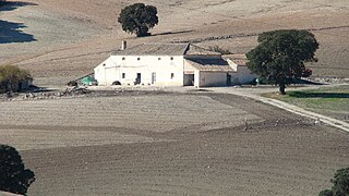
A cortijo is a type of traditional rural dwelling in the southern half of Spain, including all of Andalusia and parts of Extremadura and Castile-La Mancha.
Olegario Pachón Núñez was an Extremaduran anarchist.


