Don Benito

Last updated • 2 min readFrom Wikipedia, The Free Encyclopedia
Don Benito
Municipality
Iglesia Parroquial de San Juan Don Benito.jpg
Parish church of San Juan
Bandera Don Benito.png
Escudo Don benito.png
Spain Extremadura location map.svg
Red pog.svg
Don Benito
Location in Extremadura
Coordinates: 38°57′16.3″N5°51′42.2″W / 38.954528°N 5.861722°W / 38.954528; -5.861722
CountryFlag of Spain.svg  Spain
Autonomous Community Flag of Extremadura with COA.svg  Extremadura
Province Badajoz
Comarca Las Vegas Altas
Founded15th century
Government
  MayorJose Luis Quintana Álvarez (PSOE-Extremadura)
Area
  Total
5,616 km2 (2,168 sq mi)
Elevation
280 m (920 ft)
Population
 (2018) [1]
  Total
37,010
  Density6.6/km2 (17/sq mi)
Time zone UTC+1 (CET)
  Summer (DST) UTC+2 (CEST (GMT +2))
Postal code
06400
Area code +34 (Spain) + 924 (Badajoz)
Website Official website
Ave Maria Amphitheatre Anfiteatro Ave Maria de Don Benito.jpg
Ave María Amphitheatre
Las Albercas Park Parque Municipal de las Albercas.jpg
Las Albercas Park

Don Benito (Spanish pronunciation: [dombeˈnito] ) is a Spanish town and municipality in the province of Badajoz, Extremadura, near the left bank of the river Guadiana. According to the 2014 census, [2] the municipality has a population of 37,011.

Contents

History

Don Benito dates from the 15th century, when it was founded by refugees from Don Llorente, who deserted their own town due to the danger of floods from the Guadiana. [3]

On 28 March 1809, the 9 km separating Don Benito from Medellín was the site of a major French victory against Spanish troops during the Peninsular War.

By 2021, the municipal government of Don Benito worked alongside that of Villanueva de la Serena to fuse the two neighbouring municipalities into a single one, paving the way for a 2022 non-binding consultation. [4] On 8 November 2021, the Council of Ministers sanctioned the celebration of the consultation, [5] to be held on 20 February 2022. Both municipalities approved the merging, in the case of Don Benito by a whisker (a 66.2% of yes votes relative to the 66.0% threshold set in advance). [6]

Demographics

Don Benito

Geography

Don Benito has 37,048 inhabitants, and is part of an urban area with Villanueva de la Serena (26,071 inhabitants) 5 km away.

The municipality is composed by the town of Don Benito and seven villages:

SettlementPopulation (2012)
Don Benito32,783
Conquista del Guadiana 133
Gargáligas 549
Hernán Cortés 921
Ruecas 718
El Torviscal 549
Valdehornillos 664
Vivares 731

Climate

Don Benito has a hot summer mediterranean climate (Köppen classification: Csa), bordering on a cold semi-arid climate (BSk). [7] The winters are mild, although temperatures very occasionally drop below 0 °C (32 °F) during the coldest nights of the year. Summers are hot to very hot and temperatures often exceed 35 °C (95 °F) and occasionally exceed 40 °C (104 °F).

Precipitation is moderately scarce throughout the year, averaging 400 millimetres (16 in) annually. Autumn is the season with the most rainfall, while the summers are dry.

Climate data for Don Benito, 1991-2020 normals, extremes (1989-present)
MonthJanFebMarAprMayJunJulAugSepOctNovDecYear
Record high °C (°F)21.8
(71.2)
24.7
(76.5)
29.7
(85.5)
37.3
(99.1)
38.7
(101.7)
42.9
(109.2)
44.1
(111.4)
43.7
(110.7)
42.3
(108.1)
35.8
(96.4)
26.6
(79.9)
22.0
(71.6)
44.1
(111.4)
Mean daily maximum °C (°F)13.0
(55.4)
15.4
(59.7)
19.2
(66.6)
21.8
(71.2)
26.4
(79.5)
31.4
(88.5)
34.5
(94.1)
34.3
(93.7)
30.1
(86.2)
24.4
(75.9)
17.1
(62.8)
13.8
(56.8)
23.5
(74.2)
Daily mean °C (°F)8.1
(46.6)
9.8
(49.6)
12.9
(55.2)
15.4
(59.7)
19.5
(67.1)
23.8
(74.8)
26.2
(79.2)
26.2
(79.2)
22.9
(73.2)
18.2
(64.8)
12.2
(54.0)
9.2
(48.6)
17.0
(62.7)
Mean daily minimum °C (°F)3.1
(37.6)
4.1
(39.4)
6.6
(43.9)
9.0
(48.2)
12.5
(54.5)
16.1
(61.0)
17.9
(64.2)
18.2
(64.8)
15.7
(60.3)
12.0
(53.6)
7.2
(45.0)
4.7
(40.5)
10.6
(51.1)
Record low °C (°F)−7.9
(17.8)
−5.3
(22.5)
−4.4
(24.1)
0.1
(32.2)
3.6
(38.5)
8.1
(46.6)
8.7
(47.7)
10.4
(50.7)
7.8
(46.0)
3.1
(37.6)
−2.4
(27.7)
−6.0
(21.2)
−7.9
(17.8)
Average rainfall mm (inches)41.9
(1.65)
34.3
(1.35)
41.3
(1.63)
43.5
(1.71)
32.1
(1.26)
10.1
(0.40)
2.8
(0.11)
3.4
(0.13)
25.2
(0.99)
63.3
(2.49)
51.6
(2.03)
50.4
(1.98)
399.9
(15.73)
Source: Agencia Estatal de Meteorologia (AEMET OpenData) [8]

Transport

The town is served by a railway station on the Ciudad Real-Badajoz railway, part of an international line that links Madrid with Lisbon. It has been interested, along with the nearby Villanueva de la Serena, by a project of a tramway, not yet finalized. [9] [10] The town is also the southern terminus of the EXA2 motorway from Miajadas.

Famous residents

Twin towns

Related Research Articles

<span class="mw-page-title-main">Badajoz</span> Municipality in Extremadura, Spain

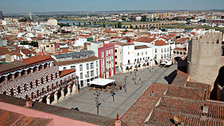
Badajoz is the capital of the Province of Badajoz in the autonomous community of Extremadura, Spain. It is situated close to the Portuguese border, on the left bank of the river Guadiana. The population in 2011 was 151,565.

<span class="mw-page-title-main">Extremadura</span> Autonomous community of Spain

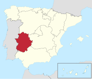
Extremadura is a landlocked autonomous community of Spain. Its capital city is Mérida, and its largest city is Badajoz. Located in the central-western part of the Iberian Peninsula, it is crossed from east to west by the Tagus and Guadiana rivers. The autonomous community is formed by the two largest provinces of Spain: Cáceres and Badajoz. Extremadura is bordered by Portugal to the west and by the autonomous communities of Castile and León (north), Castilla–La Mancha (east), and Andalusia (south).

<span class="mw-page-title-main">Mérida, Spain</span> Municipality in Extremadura, Spain

Mérida is a city and municipality of Spain, part of the Province of Badajoz, and capital of the autonomous community of Extremadura. Located in the western-central part of the Iberian Peninsula at 217 metres above sea level, the city is crossed by the Guadiana and Albarregas rivers. The population was 60,119 in 2017.

<span class="mw-page-title-main">Province of Badajoz</span> Province of Spain

The province of Badajoz is a province of western Spain located in the autonomous community of Extremadura. It was formed in 1833. It is bordered by the provinces of Cáceres in the north, Toledo, Ciudad Real in the east, Córdoba in the south-east, Seville, and Huelva in the south and Portugal in the west.

<span class="mw-page-title-main">Güímar</span> Municipality in Canary Islands, Spain

Güímar is the name of a municipality, town and valley in the eastern part of the Spanish island of Tenerife, one of the Canary Islands, and part of Santa Cruz de Tenerife (province). The municipality extends for 102.9 square kilometers from the mountainous interior to the beaches on the Atlantic, and borders the municipalities of La Orotava, Arafo and Fasnia. Its estimated population is 18,589 (2013). The TF-1 motorway passes through the municipality.

<span class="mw-page-title-main">Villanueva de la Serena</span> City

Villanueva de la Serena is a city in the Province of Badajoz, Extremadura, Spain. It has a population of 26,111 (2010) and forms part of a larger urban area with the neighbouring town of Don Benito.

<span class="mw-page-title-main">Montoro</span> Municipality in Andalusia, Spain

Montoro is a municipality of Spain belonging to the province of Córdoba, Andalusia. Housing lies on a bend of the river Guadalquivir, which envelopes from West, North, and East.

<span class="mw-page-title-main">El Ejido</span> Place in Andalusia, Spain

El Ejido is a municipality of Almería province, in the autonomous community of Andalusia, Spain. It is located 32 km from Almería with a surface area of 227 km2, and as reported in 2014 had 84,144 inhabitants. El Ejido is the centre of production for fruit and vegetables in the "Comarca de El Poniente". The work opportunities the city provides attract many foreign farmhands, who look for jobs mainly in the greenhouses there. Some greenhouses have begun using computer-controlled hydroponics systems, thus saving on labour, improving efficiency and the local economy.

<span class="mw-page-title-main">Coria, Cáceres</span> Municipality in Extremadura, Spain

Coria is a municipality of Spain belonging to the province of Cáceres, Extremadura. In addition to the town of the same name, the municipality also comprises the settlements of Puebla de Argeme and Rincón del Obispo. With a population of has 12,531 inhabitants, Coria is the fourth most-populated municipality in the province.

<span class="mw-page-title-main">Las Vegas Altas</span> Comarca in Extremadura, Spain

Las Vegas Altas, also known as Vegas Altas del Guadiana, is a comarca in the province of Badajoz, Extremadura, Spain. Its capital and administrative center is the urban area of the municipalities of Don Benito and Villanueva de la Serena. The comarca contains 16 municipalities and 90,697 inhabitants.

The EX-A2 is an autovía in Extremadura. It originates from the Autovía A-5 near the town of Miajadas and ends at the EX-206, a road that connects Don Benito and Villanueva de la Serena.

<span class="mw-page-title-main">Climate of Spain</span>

The climate of Spain is highly diverse and varies considerably across the country's various regions. In fact, Spain is sometimes described as the most climatically diverse country in Europe and has 13 different Köppen, climates.

<span class="mw-page-title-main">Battle of the Merida pocket</span> Battle during the Spanish Civil War

The battle of the Mérida pocket, also known as the closing of the Mérida pocket, was a military engagement which took place during the Spanish Civil War in July 1938 in La Serena zone of Badajoz Province, Extremadura.

Guadiana, is a Spanish town and municipality of the Province of Badajoz, in the autonomous community of Extremadura. The municipality covers an area of 30.05 square kilometres (11.60 sq mi) and as of 2015 had a population of 2,527 people.

José Agustín Izquierdo Tena is a Spanish retired footballer who played as a central midfielder, and is a manager.

In the run up to the 2015 Spanish local elections, various organisations carried out opinion polling to gauge voting intention in local entities in Spain. Results of such polls for municipalities in Extremadura are displayed in this article. The date range for these opinion polls is from the previous local elections, held on 22 May 2011, to the day the next elections were held, on 24 May 2015.

Francisco Javier Pereira Megía is a Spanish football manager and former player who played as a right winger.

Luciano Pérez de Acevedo Amo was a Spanish politician and lawyer. He served as President of the Diputación Provincial de Badajoz from 1979 to 1983.

<span class="mw-page-title-main">Miguel Ángel Gallardo (politician)</span>

Miguel Ángel Gallardo Miranda is a Spanish Socialist Workers' Party (PSOE) politician. He was the mayor of his hometown of Villanueva de la Serena from 2003 to 2024, when he was elected secretary general of the PSOE in Extremadura.

References

  1. Municipal Register of Spain 2018. National Statistics Institute.
  2. Instituto Nacional de Estadística (INE)
  3. Wikisource-logo.svg One or more of the preceding sentences incorporates text from a publication now in the public domain :  Chisholm, Hugh, ed. (1911). "Don Beníto". Encyclopædia Britannica . Vol. 8 (11th ed.). Cambridge University Press. p. 411.
  4. "Villanueva de la Serena y Don Benito trabajan en la fusión de ambas municipios, que someterán a consulta popular en 2022". Europa Press . 15 September 2021.
  5. Domeque, Estrella. "El Consejo de Ministros aprueba la consulta popular sobre la unión de Don Benito y Villanueva de la Serena". Hoy .
  6. Viejo, Manuel (20 February 2022). "Villanueva de la Serena y Don Benito aprueban su fusión al límite". El País .
  7. Meteorología, Agencia Estatal de. "Valores climatológicos normales - Agencia Estatal de Meteorología - AEMET. Gobierno de España". www.aemet.es (in Spanish). Retrieved 2024-05-04.
  8. "AEMET OpenData" . Retrieved 4 May 2024.
  9. (in Spanish) "The circular tramway Don Benito-Villanueva in the future". El Periódico Extremadura , 29-9-2007
  10. (in Spanish) "The project of the Don Benito-Villanueva tramway will be taken by the regional board". Hoy , 12-2-2008