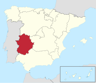
Hornachos

Last updated
Hornachos
Hornachos in Spain 01.jpg
Escudo de Hornachos.svg
Seal
Spain Extremadura location map.svg
Red pog.svg
Hornachos
Location of Hornachos within Extremadura
Coordinates: 38°33′20″N6°4′11″W / 38.55556°N 6.06972°W / 38.55556; -6.06972
Country Spain
Autonomous community Extremadura
Province Badajoz
Municipality Hornachos
Government
  AlcaldeFrancisco Buenavista García (PSOE)
Area
  Total295.9 km2 (114.2 sq mi)
Elevation
538 m (1,765 ft)
Population
 (2018) [1]
  Total3,639
  Density12/km2 (32/sq mi)
Time zone UTC+1 (CET)
  Summer (DST) UTC+2 (CEST)

Hornachos is a municipality located in the province of Badajoz, Extremadura, Spain. According to the 2005 census (INE), the municipality has a population of 3,840 inhabitants.

Contents

History

The first human settlements in the mountain range of Hornachos are dated from prehistoric times as shown by the cave paintings in the quartzite rocks. These paintings were made between the Neolithic and the Bronze Age, around 2,000-3,000 BCE.

The city was occupied during the Roman period and it was then when it received the name of Fornacis due to the iron mines and where the name 'Hornachos' ultimately derives. Archaeological evidence (Hornachuelos Oppidum) shows that the site had certain importance in Emerita Augusta during the 2nd and 1st centuries BCE. During the Visigoths' time the tradition sets Hornachos as the refuge of Saint Hermenegild when escaping from his father, King Leovigild.

The defensive fortress crowning the village was built during the Al-Andalus period. In 1234 Hornachos was occupied by the Order of Santiago, as a land grant by Ferdinand III of Castile, [2] However, this was not originally a cause of concern for the majority Muslim -then Morisco after 1502- population. Nevertheless, at the end of the 16th century the village was surrounded by a wall and there were more than 10,000 inhabitants, being the most important Morisco centre in Spain. The Spanish captain Alonso de Contreras narrates in his memoir how he found a stash of arms stored by some Moriscos, and years later was accused of planning a revolt with said Moriscos. On April 9, 1609, King Philip III of Spain decreed the expulsion of the Moriscos. The village underwent a period of decline.

These moriscos refugees settled in Morocco, near Bou Regreg and Salé (modern-day Rabat), and went on to create a small independent maritime republic, known as the Republic of Bou Regreg or Republic of Salé, which was a haven for corsair activity in the region.

Nowadays the village keeps the heritage from the past in its steep streets following the Moorish building schemes as it is shown in places as Ribera, San Francisco, Chamorro, Peña, Enfermería o Plata, Tellada, Larga, Gata, Nogueras, etc.

Sites of interest

The most characteristic and outstanding site of Hornachos is its castle built on the top of the hill by the berbers in the 9th century and whose remains observe the daily life of the hornachegos.

Other of the most relevant monuments of Hornachos is the Church of the Purísima Concepción, a Mudejar work which stands as a unique example in the region and which has been recently declared Monument of Historical and Artistic Interest in Extremadura.

Purísima Concepción Church

The building is characterised by the use of brick as the main material and the dominant geometrical character, distinctly Islamic, emerged conspicuously in the accessory crafts using cheap materials elaborately worked—tilework, brickwork, wood carving, plaster carving, and ornamental metals. The tiling patterns stand out as the Ferdinand and Isabella coat of arms. The church tower has 24 spaces, 6 in each side.

Other landmarks

Other landmarks include the Franciscan Convent of San Ildefonso, founded in 1526 by Charles I of Spain, and which keeps a rich set of altarpieces, paintings and sculptures. In its facade, nowadays very damaged, still displays the original imperial coat of arms of Charles I.

An important site is the Church of the Remedios, built in XVI and remodeled in 1892, surrounded by a square covered by palm trees and where the festivities of September are celebrated.

Very relevant within the Hornachos' monuments are its traditional fountains as Los Moros, Los Cristianos, Palomas, Cuatro Caños, Ribera, San Francisco, Almagrera, Maxicaco, San Roque, Santa, Nueva, etc.

El Pósito, situated in the outskirts of the village, was used by the moriscos as a mosque and it has been recently restored.

Geography: flora and fauna

The Hornachos mountain range constitutes the southerner mountains of the Central Sierras of Badajoz. The most important formations are the Sierra Grande and the Sierra de los Pinos with a maximum height of 951 m in the Hornachos Hill. The main rivers which flow along the area are the Palomillas river and the Matachel. The most characteristic elements of the landscape is the dehesa or meadow of holm-oaks and cork oaks. The rest has a Mediterranean vegetation, characterized by drought-resistant plants, commonly reduced to scrub status (matorral). Some common plants are also the retama sphaerocarpa, the genista hirsuta, the erica australis and the narrow-leaved cistus.

Dehesa

In the highest part of the Sierra the Juniperus oxycedrus appears with great splendor. There are more than 600 ha. inside the protected area ZEC-ZEPA. Within this area a curious plant, the Erodium mouretii, grows being an endemic species only present in some spots of Extremadura, Andalusia and Northern Morocco.

Sierra

The Sierra is the ideal setting for plentiful animal life, being outstanding the great variety of birds of prey. Within the ZEC-ZEPA area more than 228 different species have been found, a high number if we take into account the limited zone (12,000 ha). The Spanish imperial eagle and other large birds such as the vulture, the eagle owl, the buzzard, the falcon, the kite are native of these mountains. During autumn and winter the Sierra also becomes the shelter for migrant birds such as the European robin or the pyrrhula.

The association ADENEX is responsible for a Natural Reserve and research centre in this location.

Finally another appealing natural spot is the reservoir of Los Molinos.

Feast and traditions

Most of the festivities which take place in Hornachos have their origin in religious traditions. One of the most important is the Candelas, celebrated on 2 February. The inhabitants gather around huge bonfires, where is thought that all the evil spirits and the previous bad experiences are burnt. In February Hornachos celebrates the carnival, the merrymaking and festivity that takes place in the last days and hours before the Lenten season. Home-made and elaborate costumes, parades, parties and various other festivities mark such celebration.

The Holy Week, the week between Palm Sunday and Easter, is observed with special solemnity as a time of devotion to the passion of Jesus Christ beginning with the traditional blessing and procession of palms and olive branches. The end of celebration is on Easter Sunday when the traditional white cakes are blessed. On 15 May, San Isidro, Hornachos begins a traditional feast where all the inhabitants share a nice country day to eat and drink with their neighbours. The religious festivity of San Juan is celebrated on 24 June, where the Night of the Fire- the Night of the Water takes place. People wet their heads in the San Francisco basin, with the belief that they will not suffer headaches until the following year. In the middle of August, the Emigrant feast is held dedicated to the ones who had to abandon their village and who usually return on this date. However the most important festivity begins 8 September, Nuestra Señora de los Remedios, patroness of Hornachos, where the whole village organizes parties, shows and encierros ("enclosing") of the bulls, when they are driven through the streets behind crowds of skillfully dodging men and boys.

Related Research Articles

Extremadura Autonomous community of Spain

Extremadura is an autonomous community of Spain. Its capital city is Mérida. Located in the central-western part of the Iberian Peninsula, it is made up of the two largest provinces of Spain: Cáceres and Badajoz. Extremadura is bordered by Portugal to the west and by the autonomous communities of Castile and León (north), Castilla–La Mancha (east) and Andalusia (south). Its official language is Spanish.

Province of Badajoz Province of Spain

The province of Badajoz is a province of western Spain located in the autonomous community of Extremadura. It was formed in 1833. It is bordered by the provinces of Cáceres in the north, Toledo, Ciudad Real in the east, Córdoba in the south-east, Seville, and Huelva in the south and Portugal in the west.

Cáceres, Spain Municipality in Extremadura, Spain

Cáceres is a city of Spain located in the autonomous community of Extremadura. It is the capital and most populated municipality of the province of Cáceres.

Province of Cáceres Province of Spain

The province of Cáceres is a province of western Spain, and makes up the northern half of the autonomous community of Extremadura. Its capital is the city of Cáceres. Other cities in the province include Plasencia, Coria, Navalmoral de la Mata and Trujillo, the birthplace of Francisco Pizarro González. As of 2014, the province had 408,703 inhabitants, of whom a quarter lived in the capital. The Tagus river runs through the province.

Azuaga Municipality in Extremadura, Spain

Azuaga is a town located in the province of Badajoz in southern Extremadura, bordering the Andalusian provinces of Seville and Córdoba in Spain. Azuga is 140 km from Badajoz, 125 km from Córdoba, and 140 km from Seville, in the foothills of Sierra Morena in the frontier region of Campiña Sur.

Trujillo, Cáceres Municipality in Extremadura, Spain

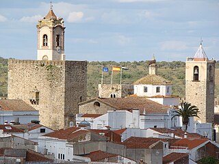
Trujillo is a municipality located in Extremadura, an autonomous community of Spain in the Province of Cáceres. It had 9,086 inhabitants. Originally settled on a granite knoll which was readily fortified, the town now extends to the south-east of its original site. Trujillo is both a centre for tourism, with over 25 hotels, and a regional market town.

Monfragüe

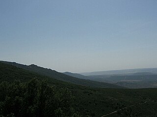
Monfragüe is a Spanish national park noted for its bird-life. It is situated in the center of a triangle formed by Plasencia, Trujillo and the city of Cáceres within the province of Cáceres. Monfragüe is also a comarca of Extremadura, western Spain.

Villanueva de la Serena city

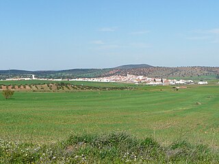
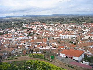
Villanueva de la Serena is a city in the Province of Badajoz, Extremadura, Spain. It has a population of 26,111 (2010) and forms part of a larger urban area with the neighbouring town of Don Benito.

Remedios, Cuba Municipality in Villa Clara, Cuba

Remedios, also known as San Juan de los Remedios, is a city and municipality located 3 miles (4.8 km) from the northern coast of Cuba, in the center of the island. It is the oldest Spanish settlement in the former Las Villas province. It is now part of the province of Villa Clara.

Villanueva del Rosario, Andalusia Place in Andalusia, Spain

Villanueva del Rosario is a town and municipality in the province of Málaga in the autonomous community of Andalusia in southern Spain. It is located off the motorway from Málaga to Granada and Seville. It is situated in the northeast of the province. It belongs to the comarca of Nororma.

Guijo de Santa Bárbara municipality in Extremadura, Spain

Guijo de Santa Bárbara is a municipality located in the province of Cáceres, Extremadura, Spain. According to the 2005 census (INE), the municipality has a population of 429 inhabitants.

Cordobilla de Lácara Place in Extremadura, Spain

Cordobilla de Lácara is a municipality located in the province of Badajoz, Extremadura, Spain. According to the 2005 census (INE), the municipality has a population of 1023 inhabitants.

Fregenal de la Sierra Place in Extremadura, Spain

Fregenal de la Sierra is a municipality located in the province of Badajoz, Extremadura, Spain.

Retamal de Llerena Place in Extremadura, Spain

Retamal de Llerena is a municipality located in the province of Badajoz, Extremadura, Spain. According to the 2008 census (INE), it has a population of 497 people.

Llera, Badajoz Municipality in Extremadura, Spain

Llera is a Spanish municipality in the province of Badajoz, Extremadura, western Spain. According to the 2014 census, the municipality has a population of 905 inhabitants.

Sierra Suroeste Comarca in Extremadura, Spain

Sierra Suroeste is a comarca located in southwestern province of Badajoz in the autonomous community of Extremadura, western Spain. Its capital and largest city is Jerez de los Caballeros.

Juan de Mendoza y Velasco, Marquis de la Hinojosa, Governor of the Duchy of Milan, 1612–1616, Viceroy of Navarre, 1620–1623, Spanish Ambassador in England in 1623 to discuss with James I, the regnant father of the later king Charles I of England, the requirements to be met, eventually, by English politicians to arrange the marriage of Prince Charles to Maria of Austria, sister of the then nineteen-year-old ruling king Philip IV of Spain. A knight of the Military Order of Santiago, deceased 24 December 1628, he was awarded the title of marquis de la Hinojosa by King Philip III of Spain, on 11 February 1612. Although it is claimed that his father was the 5th Count of Castrogeriz, it seems after careful research that he came rather from a family of landed squires, his father, reported as Antonio Gómez Manrique de Mendoza y Sandoval, being the 6th Sieur of Castrojeriz, and 4th Sieur of Villazopeque, who married first to a certain Isabel de Velasco y Enríquez de Ribera, also, apparently, from a rather modest branch of rural proprietors, albeit pretending to some sort connections with this powerful de Velasco ducal family.

Montes de Toledo

The Montes de Toledo are one of the main systems of mountain ranges in the Iberian Peninsula. They divide the drainage basin of the Tagus from the basin of the Guadiana. The highest peak is 1,603 m (5,259 ft) high La Villuerca.

Aguilar del Río Alhama Municipality in La Rioja, Spain

Aguilar del Río Alhama is a village in the province and autonomous community of La Rioja, Spain. The municipality covers an area of 54.11 square kilometres (20.89 sq mi) and as of 2011 had a population of 549 people. It is located in a low altitude mountainous area, in the foothills of the Iberian System. It belongs to the region of Rioja Baja and is washed by the waters of the Alhama river.

Sierra de San Pedro

Sierra de San Pedro is a mountain range in the greater Montes de Toledo range, Spain. It is named after Saint Peter the apostle and rises in the limits of Cáceres and Badajoz Provinces, in the western part of the autonomous community of Extremadura close to its border with Portugal. This range gives its name to the Sierra de San Pedro - Los Baldíos comarca.

References

  1. Municipal Register of Spain 2018. National Statistics Institute.
  2. Historia de España, Ramón Menéndez Pidal, Tomo XIII, Castilla y León (1217-1349) p. 50, Espasa-Calpe, Madrid 1990 ISBN   84-239-4800-5

Coordinates: 38°28′N6°10′W / 38.467°N 6.167°W / 38.467; -6.167