Arroyo de San Serván is a municipality located in the province of Badajoz, Extremadura, Spain. According to the 2012 census (INE), the municipality has a population of 4267 inhabitants. The town's first census was held in 1842, as part of Badajoz.
Entrín Bajo is a municipality located in the province of Badajoz, Extremadura, Spain. According to the 2005 census (INE), the municipality has a population of 605 inhabitants.
La Haba is a municipality located in the province of Badajoz, Extremadura, Spain. According to the 2005 census (INE), the municipality has a population of 1441 inhabitants.

Higuera la Real is a municipality located in the province of Badajoz, Extremadura, Spain. According to the 2005 census (INE), the municipality has a population of 2505 inhabitants.

La Lapa is a municipality located in the province of Badajoz, Extremadura, Spain. According to the 2006 census (INE), the municipality has a population of 314 inhabitants.

Lobón is a municipality located in the province of Badajoz, Extremadura, Spain. According to the 2012 census (INE), the municipality has a population of 2,869 inhabitants.

Montemolín is a municipality located in the province of Badajoz, Extremadura, Spain. According to the 2005 census (INE), the municipality has a population of 1582 inhabitants.

Puebla de la Reina is a municipality located in the province of Badajoz, Extremadura, Spain. According to the 2005 census (INE), the municipality has a population of 912 inhabitants.
Retamal de Llerena is a municipality located in the province of Badajoz, Extremadura, Spain. According to the 2008 census (INE), it has a population of 497 people.

Salvaleón is a municipality located in the province of Badajoz, Extremadura, Spain. According to the 2005 census (INE), the municipality has a population of 2172 inhabitants.

San Pedro de Mérida is a municipality located in the province of Badajoz, Extremadura, Spain. According to the 2005 census (INE), the municipality has a population of 845 inhabitants.

Talavera la Real is a municipality located in the province of Badajoz, Extremadura, Spain. According to the 2006 census (INE), the municipality has a population of 5255 inhabitants.

Torremejía is a municipality located in the province of Badajoz, Extremadura, Spain. According to the 2006 census (INE), the municipality has a population of 2184 inhabitants.

Valdelacalzada is a municipality located in the province of Badajoz, Extremadura, Spain. According to the 2005 census (INE), the municipality has a population of 2,700 inhabitants.
Valencia del Ventoso is a municipality located in the province of Badajoz, Extremadura, Spain. According to the 2006 census (INE), the municipality has a population of 2,325 inhabitants.
Valverde de Leganés is a municipality located in the province of Badajoz, Extremadura, Spain. According to the 2005 census (INE), the municipality has a population of 3894 inhabitants.
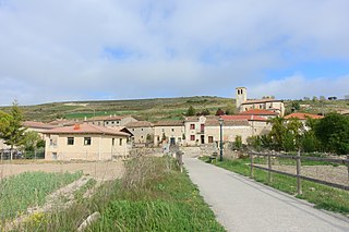
Susinos del Páramo is a municipality and town located in the province of Burgos, Castile and León, Spain. According to the 2004 census (INE), the municipality has a population of 115 inhabitants.
Navalvillar de Pela is a Spanish municipality in the province of Badajoz, Extremadura. It has a population of 4,816 (2007) and an area of 251.2 km2.

Nogales is a Spanish municipality in the province of Badajoz, Extremadura. It has a population of 692 (2007) and an area of 80.7 km².

Trujillanos is a Spanish municipality in the province of Badajoz, Extremadura, 9 km from Mérida. It has a population of 1,376 (2020) and an area of 20.3 km2.