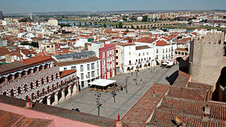
Badajoz is the capital of the Province of Badajoz in the autonomous community of Extremadura, Spain. It is situated close to the Portuguese border, on the left bank of the river Guadiana. The population in 2011 was 151,565.
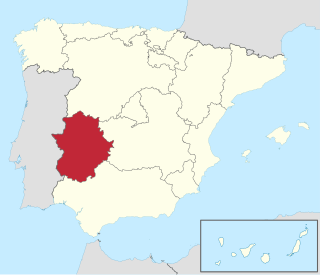
Extremadura is a landlocked autonomous community of Spain. Its capital city is Mérida, and its largest city is Badajoz. Located in the central-western part of the Iberian Peninsula, it is crossed from east to west by the Tagus and Guadiana rivers. The autonomous community is formed by the two largest provinces of Spain: Cáceres and Badajoz. Extremadura is bordered by Portugal to the west and by the autonomous communities of Castile and León (north), Castilla–La Mancha (east), and Andalusia (south).

Córdoba is one of the 50 provinces of Spain, in the north-central part of the autonomous community of Andalusia. It is bordered by the Andalusian provinces of Málaga, Seville, Jaén, and Granada, the Extremaduran province of Badajoz and the province of Ciudad Real, which is part of the autonomous community of Castile-La Mancha. Its area is 13,769 km2.

Huelva is a province of southern Spain, in the western part of the autonomous community of Andalusia. It is bordered by Portugal, the provinces of Badajoz, Seville, and Cádiz, and the Atlantic Ocean. Its capital is Huelva.

The province of Badajoz is a province of western Spain located in the autonomous community of Extremadura. It was formed in 1833. It is bordered by the provinces of Cáceres in the north, Toledo, Ciudad Real in the east, Córdoba in the south-east, Seville, and Huelva in the south and Portugal in the west.

Ciudad Victoria is the seat of the Municipality of Victoria, and the capital of the Mexican state of Tamaulipas. It is located in the northeast of Mexico at the foot of the Sierra Madre Oriental. It borders the municipality of Güémez to the north, Llera to the south, Casas Municipality to the east, and the municipality of Jaumave to the west. The city is located 246 km (153 mi) from Monterrey and 319 km (198 mi) from the US - Mexico border. Ciudad Victoria is named after the first president of Mexico, Guadalupe Victoria.
Azuaga is a town located in the province of Badajoz in southern Extremadura, bordering the Andalusian provinces of Seville and Córdoba in Spain. Azuga is 140 km from Badajoz, 125 km from Córdoba, and 140 km from Seville, in the foothills of Sierra Morena in the frontier region of Campiña Sur.

The Sierra Morena is one of the main systems of mountain ranges in Spain. It stretches for 450 kilometres from east to west across the south of the Iberian Peninsula, forming the southern border of the Meseta Central plateau and providing the watershed between the valleys of the Guadiana to the north and the west, and the Guadalquivir to the south.

Benquerencia de la Serena is a municipality in the province of Badajoz, Extremadura, Spain. According to the 2014 census, the municipality has a population of 904 inhabitants. It is located in La Serena comarca, in the area of the Sierra Morena, the local ranges being Sierra de Benquerencia, Sierra de los Tiros and Sierra de Almorchón.
La Roca de la Sierra is a municipality in the province of Badajoz, Extremadura, Spain. It has a population of 1,579 and an area of 108.58 km2. It is the location of the Monastery of San Isidro de Loriana, a Bien de Interes Cultural in a state of ruin.
Campillo de Llerena is a municipality located in the province of Badajoz, Extremadura, Spain. According to a 2005 census (INE), the municipality has a population of 1,624 inhabitants.
Castilblanco is a municipality located in the province of Badajoz, Extremadura, Spain. According to the 2005 census (INE), the municipality has a population of 1146 inhabitants.
Cordobilla de Lácara is a municipality located in the province of Badajoz, Extremadura, Spain. According to the 2005 census (INE), the municipality has a population of 1023 inhabitants.
Fregenal de la Sierra is a municipality located in the province of Badajoz, Extremadura, Spain.

Hornachos is a municipality located in the province of Badajoz, Extremadura, Spain. According to the 2005 census (INE), the municipality has a population of 3,840 inhabitants.
Retamal de Llerena is a municipality located in the province of Badajoz, Extremadura, Spain. According to the 2008 census (INE), it has a population of 497 people.

Llerena is a municipality located in the province of Badajoz, Extremadura, Spain. According to the 2007 census (INE), the municipality had a population of 5,995 inhabitants. Llerena, a town that declared itself a Historical Artistic gathering on December 29, 1966, is located in southwestern Spain. The head of the judicial and economic center of the region of the country of the same name, it is equidistant from 20 municipalities, and sits at the confluence of the District 432 and 413 National Roads.

Campiña Sur is an administrative division (comarca) in the province of Badajoz, Extremadura, Spain. Its capital and administrative center is the municipality of Llerena. It contains 21 municipalities and 32,841 inhabitants in an area of 2,798 square kilometres (1,080 sq mi).

Villanueva del Pardillo is a municipality and Spanish town of the Community of Madrid, situated 26 kilometers from the capital of Spain and nestled in the natural environment of the Cuenca del Guadarrama. It borders the municipalities of Majadahonda, Las Rozas de Madrid, Villanueva de la Cañada, Galapagar, Colmenarejo and Valdemorillo.

Villar de Plasencia is a municipality located in the province of Cáceres, in the autonomous community of Extremadura, Spain. The municipality covers an area of 24.99 square kilometres (9.65 sq mi) and as of 2011 has a population of 243 people.


