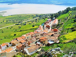
Cacín is a city located in the province of Granada, Spain. It lies to the east of the Río Cacín, from which it takes its name. According to the 2005 census (INE), the city has a population of 697 inhabitants.
Carmonita is a municipality located in the province of Badajoz, Extremadura, Spain. According to the 2006 census (INE), the municipality has a population of 650 inhabitants.
Casas de Reina is a municipality located in the province of Badajoz, Extremadura, Spain. According to the 2005 census (INE), the municipality has a population of 193 inhabitants.
Fuente del Arco is a municipality located in the province of Badajoz, Extremadura, Spain. According to the 2005 census (INE), the municipality has a population of 754 inhabitants.

La Garrovilla is a municipality located in the province of Badajoz, Extremadura, Spain. According to the 2010 census (INE), the municipality has a population of 2490 inhabitants.
La Haba is a municipality located in the province of Badajoz, Extremadura, Spain. According to the 2005 census (INE), the municipality has a population of 1441 inhabitants.

Lobón is a municipality located in the province of Badajoz, Extremadura, Spain. According to the 2012 census (INE), the municipality has a population of 2,869 inhabitants.

Magacela is a municipality located in the province of Badajoz, Extremadura, Spain. According to the 2004 census (INE), the municipality has a population of 661 inhabitants.

Montemolín is a municipality located in the province of Badajoz, Extremadura, Spain. According to the 2005 census (INE), the municipality has a population of 1582 inhabitants.

Peñalsordo is a municipality located in the province of Badajoz, Extremadura, Spain. According to the 2010 census (INE), the municipality has a population of 1180 inhabitants.

Talarrubias is a municipality located in the province of Badajoz, Extremadura, Spain. According to the 2005 census (INE), the municipality has a population of 3216 inhabitants.

Villar de Rena is a municipality located in the province of Badajoz, Extremadura, Spain. According to the 2006 census (INE), the municipality has a population of 1506 inhabitants.

El Viso de San Juan is a municipality located in the province of Toledo, Castile-La Mancha, Spain. According to the 2006 census (INE), the municipality has a population of 2339 inhabitants.

Ahillones is a Spanish municipality in the province of Badajoz, Extremadura. It has a population of 1,064 (2007) and an area of 21.5 km².
Berlanga is a Spanish municipality in the province of Badajoz, Extremadura. It has a population of 2,546 (2007) and an area of 127.8 km2.
Campanario is a Spanish municipality in the province of Badajoz, Extremadura. It has a population of 5,470 (2007) and an area of 284 km².
Capilla is a Spanish municipality in the province of Badajoz, Extremadura. It has a population of 189 (2007) and an area of 147 km2.
Navalvillar de Pela is a Spanish municipality in the province of Badajoz, Extremadura. It has a population of 4,816 (2007) and an area of 251.2 km2.

Puebla de la Calzada is a Spanish municipality in the province of Badajoz, Extremadura. It has a population of 5,685 (2007) and an area of 14.2 km².

Reina is a Spanish municipality in the province of Badajoz, Extremadura. As of 2007, it had a population of 189 and consisted of an area of 64.7 km².