Alpena, South Dakota

Last updated

Alpena, South Dakota
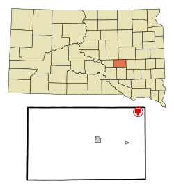
Jerauld County South Dakota Incorporated and Unincorporated areas Alpena Highlighted.svg
Location in Jerauld County and the state of South Dakota
Coordinates: 44°10′59″N98°22′06″W / 44.18306°N 98.36833°W / 44.18306; -98.36833
Country United States
State South Dakota
County Jerauld
Platted1883 [1]
Area
[2]
  Total1.65 sq mi (4.26 km2)
  Land1.63 sq mi (4.22 km2)
  Water0.01 sq mi (0.04 km2)
Elevation
[3]
1,322 ft (403 m)
Population
 (2020) [4]
  Total212
  Density129.98/sq mi (50.19/km2)
Time zone UTC-6 (Central (CST))
  Summer (DST) UTC-5 (CDT)
ZIP code
57312
Area code 605
FIPS code 46-01020 [5]
GNIS feature ID1267264 [3]
Website www.alpenasd.com

Alpena (pronounced al-PEE'-nuh [6] ) is a town in northeastern corner of Jerauld County, South Dakota, United States. The population was 286 at the 2010 census.

Contents

History

Alpena was platted in 1883, and most likely was named after Alpena, Michigan, the native home of the town's proprietor. [7] A post office has been in operation at Alpena since 1883. [8]

Geography

According to the United States Census Bureau, the town has a total area of 1.64 square miles (4.25 km2), of which 1.63 square miles (4.22 km2) is land and 0.01 square miles (0.03 km2) is water. [9]

Demographics

Historical population
CensusPop.Note
1900 153
1910 417172.5%
1920 57638.1%
1930 499−13.4%
1940 440−11.8%
1950 426−3.2%
1960 407−4.5%
1970 307−24.6%
1980 288−6.2%
1990 251−12.8%
2000 2655.6%
2010 2867.9%
2020 212−25.9%
U.S. Decennial Census [10] [4]

2010 census

As of the census [11] of 2010, there were 286 people, 110 households, and 73 families residing in the town. The population density was 175.5 inhabitants per square mile (67.8/km2). There were 124 housing units at an average density of 76.1 per square mile (29.4/km2). The racial makeup of the town was 86.7% White, 0.7% Native American, 1.0% Pacific Islander, 9.8% from other races, and 1.7% from two or more races. Hispanic or Latino of any race were 23.8% of the population.

There were 110 households, of which 30.9% had children under the age of 18 living with them, 53.6% were married couples living together, 8.2% had a female householder with no husband present, 4.5% had a male householder with no wife present, and 33.6% were non-families. 27.3% of all households were made up of individuals, and 8.2% had someone living alone who was 65 years of age or older. The average household size was 2.60 and the average family size was 3.18.

The median age in the town was 34.3 years. 26.2% of residents were under the age of 18; 5.6% were between the ages of 18 and 24; 27.9% were from 25 to 44; 24.8% were from 45 to 64; and 15.4% were 65 years of age or older. The gender makeup of the town was 51.0% male and 49.0% female.

2000 census

As of the census [5] of 2000, there were 265 people, 113 households, and 78 families residing in the town. The population density was 161.1 inhabitants per square mile (62.2/km2). There were 122 housing units at an average density of 74.2 per square mile (28.6/km2). The racial makeup of the town was 99.62% White and 0.38% Asian. Hispanic or Latino of any race were 0.38% of the population.

There were 113 households, out of which 30.1% had children under the age of 18 living with them, 58.4% were married couples living together, 8.0% had a female householder with no husband present, and 30.1% were non-families. 28.3% of all households were made up of individuals, and 8.8% had someone living alone who was 65 years of age or older. The average household size was 2.35 and the average family size was 2.82.

In the town, the population was spread out, with 24.9% under the age of 18, 6.0% from 18 to 24, 23.0% from 25 to 44, 28.3% from 45 to 64, and 17.7% who were 65 years of age or older. The median age was 41 years. For every 100 females, there were 108.7 males. For every 100 females age 18 and over, there were 114.0 males.

The median income for a household in the town was $35,455, and the median income for a family was $38,000. Males had a median income of $25,625 versus $16,607 for females. The per capita income for the town was $13,533. About 10.4% of families and 14.4% of the population were below the poverty line, including 18.5% of those under the age of eighteen and none of those sixty five or over.
Media

The area is served by the True Dakotan weekly newspaper. [12]

Notable person

See also

Related Research Articles

<span class="mw-page-title-main">Jerauld County, South Dakota</span> County in South Dakota, United States

Jerauld County is a county in the U.S. state of South Dakota. As of the 2020 census, the population was 1,663. Its county seat is Wessington Springs.

<span class="mw-page-title-main">Hillman, Michigan</span> Village in Michigan, United States

Hillman is a village in Alpena and Montmorency counties in the U.S. state of Michigan. The population was 605 as of the 2020 census. Nearly all of the village is located within Hillman Township, with only a small portion extending into Green Township.

<span class="mw-page-title-main">Mantador, North Dakota</span> City in North Dakota, United States

Mantador is a city in Richland County, North Dakota, United States. The population was 67 at the 2020 census. Mantador was founded in 1893. It is part of the Wahpeton, ND-MN Micropolitan Statistical Area.

<span class="mw-page-title-main">Wolsey, South Dakota</span> Town in South Dakota, United States

Wolsey is a town in Beadle County, South Dakota, United States. The population was 459 at the 2020 census.

<span class="mw-page-title-main">Springfield, South Dakota</span> City in South Dakota, United States

Springfield is a city in Bon Homme County, South Dakota, United States. The population was 1,914 at the 2020 census. As of 2023, about 1,250 of the residents were inmates at Mike Durfee State Prison.

<span class="mw-page-title-main">Tabor, South Dakota</span> Town in South Dakota, United States

Tabor is a town in Bon Homme County, South Dakota, United States. The population was 407 at the 2020 census.

<span class="mw-page-title-main">Claremont, South Dakota</span> Town in South Dakota, United States

Claremont is a town in Brown County, South Dakota, United States. The population was 108 at the 2020 census.

<span class="mw-page-title-main">Mound City, South Dakota</span> Town in South Dakota, United States

Mound City is a town in and the county seat of Campbell County, South Dakota, United States. The population was 69 at the 2020 census.

<span class="mw-page-title-main">Florence, South Dakota</span> Town in South Dakota, United States

Florence is a town in northwestern Codington County, South Dakota, United States. It is part of the Watertown, South Dakota Micropolitan Statistical Area. The population was 337 at the 2020 census.

<span class="mw-page-title-main">Fairburn, South Dakota</span> Town in South Dakota, United States

Fairburn is a town in Custer County, South Dakota, United States. The population was 60 at the 2020 census.

<span class="mw-page-title-main">Pierpont, South Dakota</span> Town in South Dakota, United States

Pierpont is a town in northwestern Day County, South Dakota, United States. The population was 129 at the 2020 census.

<span class="mw-page-title-main">Cresbard, South Dakota</span> Town in South Dakota, United States

Cresbard is a town in Faulk County, South Dakota, United States. The population was 96 at the 2020 census.

<span class="mw-page-title-main">Stockholm, South Dakota</span> Town in South Dakota, United States

Stockholm is a town in Grant County, South Dakota, United States. The population was 102 at the 2020 census.

<span class="mw-page-title-main">Lane, South Dakota</span> Town in South Dakota, United States

Lane is a town in Jerauld County, South Dakota, United States. The population was 59 at the 2010 census.

<span class="mw-page-title-main">Wessington Springs, South Dakota</span> Town in South Dakota, United States

Wessington Springs is a town in central Jerauld County, South Dakota, United States. The population was 956 at the 2010 census. It is the county seat of Jerauld County.

<span class="mw-page-title-main">Lake City, South Dakota</span> Town in South Dakota, United States

Lake City is a town in Marshall County, South Dakota, United States. The population was 45 at the 2020 census. Fort Sisseton Historic State Park, whose fort is listed on the National Register of Historic Places, is located nearby.

<span class="mw-page-title-main">Crooks, South Dakota</span> City in South Dakota, United States

Crooks is a city in Minnehaha County, South Dakota, United States and is a suburb of Sioux Falls. The population was 1,362 at the 2020 census. Crooks was named New Hope until 1904. The town's present name honors W. A. Crooks, a local politician.

<span class="mw-page-title-main">Sherman, South Dakota</span> Town in South Dakota, United States

Sherman is a town in Minnehaha County, South Dakota, United States. The population was 81 at the 2020 census.

<span class="mw-page-title-main">Tulare, South Dakota</span> Town in South Dakota, United States

Tulare is a town in Spink County, South Dakota, United States. The population was 211 at the 2020 census.

<span class="mw-page-title-main">Mobridge, South Dakota</span> City in South Dakota, United States

Mobridge also Kȟowákataŋ Otȟúŋwahe is a city in Walworth County, South Dakota, United States. The population was 3,261 according to the 2020 census.

References

  1. "SD Towns" (PDF). South Dakota State Historical Society. Archived from the original (PDF) on February 10, 2010. Retrieved February 10, 2010.
  2. "ArcGIS REST Services Directory". United States Census Bureau. Retrieved October 15, 2022.
  3. 1 2 U.S. Geological Survey Geographic Names Information System: Alpena, South Dakota
  4. 1 2 "Census Population API". United States Census Bureau. Retrieved October 15, 2022.
  5. 1 2 "U.S. Census website". United States Census Bureau . Retrieved January 31, 2008.
  6. "Broadcast Pronunciation Guide and South Dakota Pronunciations". Associated Press. Archived from the original on June 14, 2011. Retrieved November 10, 2009.
  7. Federal Writers' Project (1940). South Dakota place-names, v.1-3. University of South Dakota. p. 21.
  8. "Jerauld County". Jim Forte Postal History. Retrieved January 22, 2015.
  9. "US Gazetteer files 2010". United States Census Bureau. Archived from the original on January 25, 2012. Retrieved June 21, 2012.
  10. "Census of Population and Housing". Census.gov. Retrieved June 4, 2016.
  11. "U.S. Census website". United States Census Bureau . Retrieved June 21, 2012.
  12. "True Dakotan". South Dakota Press Association. Archived from the original on October 2, 2010. Retrieved October 29, 2010.