
Alberta is a province of Canada. With an estimated population of 4,067,175 as of 2016 census, it is Canada's fourth most populous province and the most populous of Canada's three prairie provinces. Its area is about 660,000 square kilometres (250,000 sq mi). Alberta and its neighbour Saskatchewan were districts of the Northwest Territories until they were established as provinces on September 1, 1905. The premier is Jason Kenney as of April 30, 2019.

Alberta Provincial Highway No. 2, commonly referred to as Highway 2 or the Queen Elizabeth II Highway, is a major highway in Alberta that stretches from the Canada–United States border through Calgary and Edmonton to Grande Prairie. Running primarily north to south for approximately 1,273 kilometres (791 mi), it is the longest and busiest highway in the province carrying nearly 170,000 vehicles per day in central Calgary. Between Edmonton and Fort Macleod, the highway forms a portion of Alberta's Export Highway and the CANAMEX Corridor. More than half of Alberta's 4 million residents live in the Calgary–Edmonton Corridor created by Highway 2.
Alberta Provincial Highway No. 1, commonly referred to as Highway 1, is a major east-west highway in Southern Alberta that forms the southern mainline of the Trans-Canada Highway. It runs from the British Columbia border near Lake Louise through Calgary to the Saskatchewan border east of Medicine Hat. It continues as Highway 1 into both provinces. It spans approximately 534 km (332 mi) from Alberta's border with British Columbia in the west to its border with Saskatchewan in the east. The route is a divided expressway throughout the province with the exception of a section in central Calgary where it is an arterial thoroughfare. Twinning of the final 8.5 km (5.3 mi) of Highway 1 between Lake Louise and the British Columbia border was completed by Parks Canada and opened to traffic on June 12, 2014.

Alberta Provincial Highway No. 1A is the designation of two alternate routes off the Alberta portion of Trans-Canada Highway 1. However, it is not the only name used for spurs off Highway 1 - Highway 1X is another such designation. Despite these highways being suffixed routes of Highway 1, they are not part of the Trans-Canada Highway network, and are signed with Alberta's provincial primary highway shields instead of the Trans-Canada shields used for Highway 1.

Denare Beach is a northern village on the east shore of Amisk Lake, Saskatchewan. Located on Highway 167, the community is 20 km (12 mi) southwest of Flin Flon and 422 km (262 mi) northeast of Prince Albert.

Tofield is a town in central Alberta, Canada. It is located approximately 68 km (42 mi) east of Edmonton at the junction of Highway 14, Highway 834, and Highway 626. Beaverhill Lake is located immediately northeast of the community.
Amisk is a village in east central Alberta, Canada.

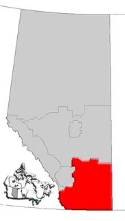
Alberta Provincial Highway No. 13, commonly referred to as Highway 13, is an east–west highway through central Alberta. It spans from Alder Flats, 7 km (4 mi) west of Highway 22, to the Alberta-Saskatchewan border. Highway 13 is about 366 kilometres (227 mi) long. East of the City of Wetaskiwin, it generally parallels a Canadian Pacific rail line.

The Northern Woods and Water Route is a 2,400-kilometre (1,500 mi) route through northern British Columbia, Alberta, Saskatchewan and Manitoba in Western Canada. As early as the 1950s community groups came together to establish a northern travel route; this was proposed as the Northern Yellowhead Transportation Route. The Northern Woods and Water Route Association was established in 1974, and encouraged promotion of the route with the promise of an increase in tourist travel. The route was designated in 1974 and is well signed throughout its component highways. The route starts at Dawson Creek as the Spirit River Highway and ends at the Perimeter of Winnipeg, Manitoba, after running through the northern regions of the western provinces. From west to east, the Northern Woods and Water Route (NWWR) incorporates portions of British Columbia Highway 49; Alberta Highways 49, 2A, 2, & 55; Saskatchewan Highways 55 & 9; Manitoba Provincial Road 283 and Trunk Highways 10, 5, 68 & 6. The halfway point of the NWWR is approximately at Goodsoil, Saskatchewan.

Lac la Biche is a large lake in north-central Alberta, Canada. It is located along the Northern Woods and Water Route, 95 km east of Athabasca. Lac la Biche has a total area of 236 km2 (91 sq mi), including 3.2 km2 (1.2 sq mi) islands area.

Beaver River is a large river in east-central Alberta and central Saskatchewan, Canada. It flows east through Alberta and Saskatchewan and then turns sharply north to flow into Lac Île-à-la-Crosse on the Churchill River which flows into Hudson Bay. The Alberta part is in the Cold Lake oil sands.
Southern Alberta is a region located in the Canadian province of Alberta. In 2004, the region's population was approximately 272,017. The primary cities are Lethbridge and Medicine Hat. The region is known mostly for agricultural production, but other sectors, such as alternative energy, film production and tourism, are emerging.
Highway 167 is a highway in the Canadian province of Saskatchewan. It runs from the Manitoba border between Creighton and Flin Flon, where it takes over from Manitoba Highway 10, to the Amisk Lake Provincial Recreation Site near the Amisk Lake Provincial Ecological Reserve. Highway 167 is about 49 km (30 mi) long.

Central Alberta is a region located in the Canadian province of Alberta.

Northern Alberta is a region located in the Canadian province of Alberta.
The Sakāwithiniwak or Woodland Cree, are a Cree people, calling themselves Nîhithaw in their own dialect of the language. They are the largest indigenous group in northern Alberta and are an Algonquian people. Prior to the 18th century, their territory extended west of Hudson Bay, as far north as Churchill. Although in western Northern Saskatchewan and Manitoba, by the 18th century, they acted as middlemen in trade with western tribes. After acquiring guns through trade, they greatly expanded their territory and drove other tribes further west and north.

The Sturgeon-Weir River is a river in east-central Saskatchewan, Canada. It flows about 130 km (81 mi) south-southeast to join the Saskatchewan River at Cumberland House, Saskatchewan. It was on the main voyageur route from eastern Canada northeast to the Mackenzie River basin. The river is a popular wilderness canoe route in Canada.

Amisk (Beaver) Lake is a lake in east-central Saskatchewan in Canada. 'Amisk' means beaver in Cree. Saskatchewan Highway 167 provides road access. Denare Beach, the largest settlement, is located on the east side of the lake.
Amisk is a Cree word for beaver. Amisk may also refer to:
The Beaver Lake Cree Nation is a First Nations band government located 105 kilometres (65 mi) northeast of Edmonton, Alberta, representing people of the Cree ethno-linguistic group in the area around Lac La Biche, Alberta, where the band office is currently located. Their treaty area is Treaty 6. The Intergovernmental Affairs office consults with persons on the Government treaty contacts list. There are two parcels of land reserved for the band by the Canadian Crown, Beaver Lake Indian Reserve No. 131 and Blue Quills First Nation Indian Reserve. The latter reserve is shared by six bands; Beaver Lake Cree Nations, Cold Lake First Nations, Frog Lake First Nation, Heart Lake First Nation, Kehewin Cree Nation, Saddle Lake Cree Nation.

