Ar'ara

Last updated

Contents

Ar'ara
  • עַרְעָרָה
  • عرعرة
Local council (from 1970)
Hebrew transcription(s)
   ISO 259 ʕarˁara
Ar'ara Mosque.jpg
Mosque in Ar'ara
Israel outline haifa.png
Red pog.svg
Ar'ara
Israel location map with stripes.svg
Red pog.svg
Ar'ara
Coordinates: 32°29′40″N35°05′39″E / 32.49444°N 35.09417°E / 32.49444; 35.09417
Grid position159/211 Israel grid
Country Israel
District Flag of Haifa.svg  Haifa
Population
 (2022) [1]
  Total
26,147
Name meaning"The juniper tree" [2]

Ar'ara (Arabic : عرعرة, Hebrew : עַרְעָרָה; lit. "Juniper tree") [2] is an Arab town in the Wadi Ara region in northern Israel. It is located southwest of Umm al-Fahm just northwest of the Green Line, and is part of the Triangle. In 2022, the population was 26,147. [1]

History

Persian to Mamluk periods

Pottery sherds from Persian period have been found here. [3]

Burial complexes from the Roman period have been excavated at Ar'ara, revealing clay lamps, glass vessels and beads, commonly used in the 1st to 4th century CE. [4] Rock-cut tombs with niches, and Byzantine period ceramics have been found. [5]

In the Crusader period, the place was known as "Castellum Arearum". In the land allocation made by sultan Baybars in 663 H. (1265-1266 C.E.), Ar'ara was shared between his amirs Ala' al-Din and Sayf al-Din Bayhaq al-Baghdadi. [6]

A few clay fragments from the Mamluk period have been found at the same location as the Roman remains. [4]

Ottoman period

Ar'ara, like the rest of Palestine, was incorporated into the Ottoman Empire in 1517. During the 16th and 17th centuries, Musmus belonged to the Turabay Emirate (1517–1683), which encompassed also the Jezreel Valley, Haifa, Jenin, Beit She'an Valley, northern Jabal Nablus, Bilad al-Ruha/Ramot Menashe, and the northern part of the Sharon plain. [7] [8]

In 1596, Ar'ara appeared in Ottoman tax registers as being in the Nahiya of Sa'ra of the Liwa of Lajjun. It had a population of 8 Muslim households and paid a fixed tax rate of 25% on agricultural products, which included wheat, barley, summer crops, olives, and goats or beehives; a total of 9,000 akçe. [9]

By the eighteenth century, the village remained in the administrative district of Lajjun, but the revenue of the place was farmed for the Mutasarrıf of Jaffa. [10] In 1838, it was noted as a village in the Jenin district. [11]

In the late nineteenth century, the site was described as:

A village of moderate size on high ground, with a spring to the east, a second to the west and a well to the south. There are rock cut tombs near. The population is stated by Consul Rogers (1859) as 400, the cultivation then being 30 feddans. [12]

A population list from about 1887 showed that Ar'arah had about 600 inhabitants; all Muslims. [13]

British Mandate

In the 1922 census of Palestine conducted by the British Mandate authorities, Ar'ara had a population 735, all Muslims. [14] This had increased in the 1931 census to 971, still all Muslims, in 150 houses. [15]

In the 1945 statistics, Ar'ara and Arah had a population of 2,290 Muslims, [16] 1,490 in Ar'ara and 800 in 'Ara, [17] and a privately owned land area of 29,537 dunums, [18] in addition to 5,802 dunams of publicly owned land. [19] Of this, 1,724 dunams were for plantations and irrigable land, 20,560 for cereals, [20] while 33 dunams were built-up (urban) land. [21]

State of Israel

Ar'ara was transferred from Jordanian to Israeli jurisdiction in 1949 under the Rhodes armistice agreements. [22]

By 1962 the area had been reduced to 7,269 dunums, partly due to expropriations of 8,236 dunums by the Israeli government in 1953–54. [18] One case of expropriation from a private landowner named Younis became a test case before the High Court of Israel in 1953, [23] as the land had been expropriated by the government without notifying the owner. [23] In 1954 the court ruled that the law did not require the owner to be notified and did not provide a right for the owner to contest the expropriation in advance. [23] This ruling and one other effectively ended the possibility of land owners using the courts to contest the seizure of their land. [23] The neighboring village of ʿAra was merged with Ar'ara in 1985.

Maqam Shaykh Khalaf

Maqam Shaykh Khalaf is the only building which was noted by the Israel Antiquities Authority in the Mandate area, and it is located on a slope by the highest point in the village, set in the middle of extensive graveyards. The Maqam is a single rectangular chamber, covered by a dome. The two top courses are chamfered towards the dome. On the north side is a doorway, and double window set inside shallow arches. There is also a set of windows on the west side. Inside, there are three cenotaphs, located east-west, close to the west wall. A mihrab is located on the south wall. The date of the building is not known, but according to A. Petersen (who inspected the place in 1994), the architecture indicate an eighteenth or early nineteenth century date. [24]

Arara 02.jpg
Panoramic view

See also

Related Research Articles

<span class="mw-page-title-main">Nahf</span> Arab town in northern Israel

Nahf is an Arab town in the Northern District of Israel. It is located in between the lower and upper Galilee, about 23 kilometres (14 mi) east of Acre. In 2022 it had a population of 13,717. Archaeologists believe that the area was an important center for viticulture in the Hellenistic period and possibly the Early Bronze Age IB period.

<span class="mw-page-title-main">Sa'sa'</span> Place in Safad, Mandatory Palestine

Sa'sa' was a Palestinian village, located 12 kilometres northwest of Safed, that was depopulated by Israeli forces during the 1948 Arab-Israeli war. The village suffered two massacres committed by Haganah forces: one in mid-February 1948 and the other at the end of October the same year. Its place has been taken since 1949 by Sasa, an Israeli kibbutz.

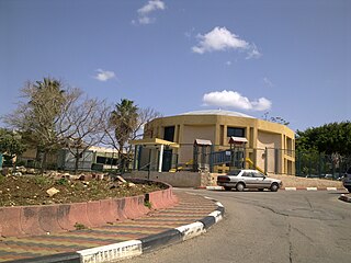
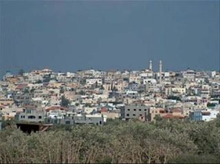
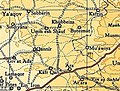
'Ara is a village in the Haifa District in northern Israel, located in the Wadi Ara valley. Since 1985, 'Ara has been part of the Ar'ara local council. It is located north of highway 65, between Ar'ara and Kfar Qara. Its population of 4,600 is almost entirely Muslim.

<span class="mw-page-title-main">Barqa, Gaza</span> Place in Gaza, Mandatory Palestine

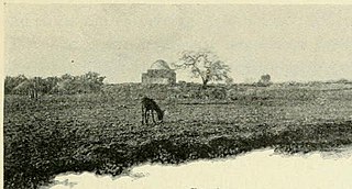
Barqa was a Palestinian Arab village located 37 km north of Gaza near the modern-day Israeli city of Ashdod. It was referred to as Barka by the Greeks and Bareca by the Romans during their rule over the ancient Philistine city. In 1945, the village had a population of 890 and total land area of 5,206 dunums.

<span class="mw-page-title-main">Meiser</span> Arab village in northern Israel

Meiser is an Arab village in northern Israel. Located half a kilometre west of the Green Line, north of the city of Baqa al-Gharbiyye in the triangle area of Wadi Ara, it is one of three Arab villages under the jurisdiction of Menashe Regional Council. In 2022 it had a population of 2,115.

<span class="mw-page-title-main">Sheikh Danun</span> Place in Northern, Israel

Sheikh Dannun ; also transliterated as Sheikh Danun and Sheikh Danon) is an Arab village located in Israel's Northern District. Since 1948, it has been made up of two old villages – Shaykh Danun and Shaykh Dawud – which were merged, and are now jointly referred to as Sheikh Dannun. Located on a hill overlooking the plains of Acre, both of these old villages were built around a tomb for a sheikh, and share a similar history. It falls under the jurisdiction of Mateh Asher Regional Council, and in 2022 it had a population of 3,031.

<span class="mw-page-title-main">Nein</span> Arab town in northern Israel

Nein — also Nain or Naim in English — is an Arab village in northern Israel. Located in the Lower Galilee, 14 kilometers (8.7 mi) south of Nazareth, Nein covers a land area of approximately 1,000 dunams and falls under the jurisdiction of Bustan al-Marj Regional Council, whose headquarters it hosts. Its total land area consisted of 3,737 dunums prior to 1962. According to the Israeli Central Bureau of Statistics, in 2022 it had a population of 1,994.

<span class="mw-page-title-main">Tur'an</span> Arab town in northern Israel

Tur'an is an Arab local council in the Northern District of Israel. It is located at the foot of Mount Tur'an and the Tur'an Valley, near the main road from Haifa to Tiberias, and about 17 kilometres (11 mi) north of Nazareth. In 2022 it had a population of 14,809, most of whom are Israeli Arabs.

<span class="mw-page-title-main">Al-Tira, Haifa</span> Place in Haifa, Mandatory Palestine

al-Tira was a Palestinian town located 7 kilometres south of Haifa. It was made up of five khirbets, including Khirbat al-Dayr where lie the ruins of St. Brocardus monastery and a cave complex with vaulted tunnels.

<span class="mw-page-title-main">Al-Muzayri'a</span> Place in Ramle, Mandatory Palestine

Al-Muzayri'a was a Palestinian village in the Ramle Subdistrict. It was depopulated in 1948. In 1998 the new Israeli city of El'ad was built over the ruins.

<span class="mw-page-title-main">Sandala, Israel</span> Arab village in northern Israel

Sandala is an Arab village in the Northern District of Israel. Near Afula, it falls under the jurisdiction of Gilboa Regional Council. In 2022 its population was 1,710.

<span class="mw-page-title-main">Sulam</span> Arab village in northern Israel

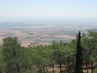
Sulam is an Arab village in north-eastern Israel. Known in ancient times as Shunama and Shunem, it is first mentioned in the Amarna Letters in the 14th century BCE. Archaeological excavations in the village attest to habitation extending from the Bronze Age through to modern times. Located near Afula, it falls under the jurisdiction of Bustan al-Marj Regional Council. In 2022 it had a population of 2,710.

<span class="mw-page-title-main">Zemer</span> Arab town in central Israel

Zemer is an Arab local council in the Central District of Israel. It is located in the Arab Triangle area, between Baqa al-Gharbiyye and Bat Hefer on Road 574. Zemer is the result of a merger of four villages – Bir al-Sika, Ibtan, Marja and Yama - in 1988.

<span class="mw-page-title-main">Taibe, Galilee</span> Arab town in northern Israel

Taibe, meaning "The goodly", or colloquially al-Tayiba al-Zu'biyya after its main clan, is a Muslim Arab village in northeastern Israel on the Issachar Plateau. It falls under the jurisdiction of Gilboa Regional Council. In 2022 it had a population of 1,986.

<span class="mw-page-title-main">Issawiya</span> Palestinian neighborhood in East Jerusalem

Al-Issawiya is a Palestinian neighborhood in East Jerusalem. It is located on the eastern slopes of the Mount Scopus ridge. To the east and north, it is bordered by Road 1, which connects Jerusalem with the settlement of Ma’ale Adumim; immediately adjoining it to the north, west and southwest are the Hadassah Medical Center, the Hebrew University campus, the Jewish settlement of French Hill and the Ofarit military base; to the south, there is a planned park, the Mount Scopus slopes national park.

<span class="mw-page-title-main">Kafr Saba</span> Place in Tulkarm, Mandatory Palestine

Kafr Saba was a Palestinian village famous for its shrine dating to the Mamluk period and for a history stretching back for two millennia. In Roman times, it was called Capharsaba and was an important town in Palestine. By around 1000, it was noted as a village with a mosque. The people of Kafr Saba were said to have come from Hebron because of crop failures.

<span class="mw-page-title-main">Al-Qabu</span> Place in Jerusalem, Mandatory Palestine

Al-Qabu was a Palestinian Arab village in the Jerusalem Subdistrict. The name is an Arabic variation of the site's original Roman name, and the ruins of a church there are thought to date to the era of Byzantine or Crusader rule over Palestine.

<span class="mw-page-title-main">Al-Qubab</span> Place in Ramle, Mandatory Palestine

Al-Qubab was a Palestinian Arab village in the Ramle Subdistrict. It was depopulated in July 1948 during the Operation Dani led by the Yiftach Brigade.

<span class="mw-page-title-main">Fardisya</span> Place in Tulkarm, Mandatory Palestine

Fardisya was a Palestinian Arab hamlet in the Tulkarm Subdistrict, 2.5 kilometres (1.6 mi) south of Tulkarm.

<span class="mw-page-title-main">Jatt, Israel</span> Arab local council in Haifa District

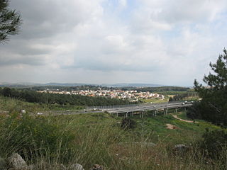
Jatt is an Arab local council in the Triangle area of Haifa District in Israel. In 2022 it had a population of 12,645.

References

  1. 1 2 "Regional Statistics". Israel Central Bureau of Statistics. Retrieved 21 March 2024.
  2. 1 2 Palmer, 1881, p.144
  3. Zertal, 2016, p. 134
  4. 1 2 Massarwa, 2007, Ar‘ara Final Report
  5. Dauphin, 1998, p. 747
  6. Ibn al-Furat, edition Lyons and Lyons, I, p. 102; II, p. 81. Cited in Petersen, 2001, p. 94
  7. al-Bakhīt, Muḥammad ʻAdnān; al-Ḥamūd, Nūfān Rajā (1989). "Daftar mufaṣṣal nāḥiyat Marj Banī ʻĀmir wa-tawābiʻihā wa-lawāḥiqihā allatī kānat fī taṣarruf al-Amīr Ṭarah Bāy sanat 945 ah". www.worldcat.org. Amman: Jordanian University. pp. 1–35. Retrieved 2023-05-15.
  8. Marom, Roy; Marom, Tepper; Adams, Matthew, J. "Lajjun: Forgotten Provincial Capital in Ottoman Palestine". Levant. doi:10.1080/00758914.2023.2202484.{{cite journal}}: CS1 maint: multiple names: authors list (link)
  9. Hütteroth and Abdulfattah, 1977, p. 159
  10. Cohen, 1973, p. 175, Cited in Petersen, 2002, p. 94
  11. Robinson and Smith, 1841, vol 3, 2nd Appendix, p. 131
  12. Conder and Kitchener, 1882, SWP I, p. 41. Also cited in Petersen, 2001, p. 94
  13. Schumacher, 1888, p. 179
  14. Barron, 1923, Table XI, Sub-district of Haifa, p. 34
  15. Mills, 1932, p. 87
  16. Department of Statistics, 1945, p. 13
  17. Department of Statistics, 1945, p. 15 note a
  18. 1 2 Sabri Jiryis (1976). "The Land Question in Israel". MERIP Reports. 47: 5–20+24–26.
  19. Government of Palestine, Department of Statistics. Village Statistics, April, 1945. Quoted in Hadawi, 1970, p. 47
  20. Government of Palestine, Department of Statistics. Village Statistics, April, 1945. Quoted in Hadawi, 1970, p. 89
  21. Government of Palestine, Department of Statistics. Village Statistics, April, 1945. Quoted in Hadawi, 1970, p. 139
  22. Family Affair: The Masarwah-Marzuks, Reli Avrahami for Haaretz, 9 July 2009
  23. 1 2 3 4 Hanna Dib Nakkara (1985). "Israeli Land Seizure under Various Defense and Emergency Regulations". Journal of Palestine Studies. 14 (2): 13–34. doi:10.1525/jps.1985.14.2.00p0125a.
  24. Petersen, 2001, p. 94

Bibliography