Location of Archbishop’s Palace, Armagh in Northern Ireland
The Archbishop's Palace, Armagh, Northern Ireland, is a landmark Neo-Classical building located on 300 acres of parkland just south of the centre of the city. The building served as primary residence of the Church of Ireland Archbishops of Armagh for over two hundred years, from 1770 to 1975, and thereafter as headquarters of Armagh City and District Council from then until April 2015 when that local authority was replaced following the reform of local government in Northern Ireland in that year.[1]
The Palace was built when then Archbishop Richard Robinson sought to relocate the principal residence of the archbishops from Drogheda to the titular city of his office. Thomas Cooley undertook the design of the initial building and Francis Johnston was responsible for designing an additional floor at a later stage.[2] The palace currently sits at the centre of the Palace Demesne Public Park, and serves as the office of the Lord Mayor of the new Armagh, Banbridge, and Craigavon Borough.[3]
The building became protected as a Grade A listed building (HB 15/18/016) in 1975.[4]
History
Archbishop Robinson, who commissioned the Palace
Richard Robinson was elected Archbishop of Armagh in 1765, which brought with it the Primacy of the Church of Ireland, and was at once dissatisfied with the modest residence provided on English Street, as well as the lack of improvement in the ancient Irish ecclesiastical capital generally. The Archbishop's Palace was constructed as part of Robinson's project to revistalise the old city generally upon his succeeding to the See of Armagh. Thomas Cooley undertook the design of the initial two-storey building, which was 7 bays wide by 4 bays deep, and Francis Johnston was responsible for designing an additional floor in the 1820s for Archbishop John George de la Poer Beresford.[2]
The house and its walled demesne were referred to by Inglis in 1834 as
in excellent order … laid out with much taste...[5]
Following the disestablishment of the Church of Ireland in 1871, Archbishop Knox sought to ensure that the palace and its grounds could continue to be used in perpetuity, as they were no longer being able to rely on tithe income for such purposes.[6] The palace ceased to be the residence of the archbishop, during the tenure of Archbishop Simms, in the 1970s.[7]
Photograph of the palace, early 20th century
From 1975 to 2015, the building served as the headquarters for Armagh City and District Council until April 2015 when that local authority was replaced following the reform of local government in Northern Ireland in that year.[1] Since April 2015 the palace has served as the office of the Lord Mayor of the new Armagh, Banbridge, and Craigavon Borough.[3]
Grounds
Features
The palace is surrounded by grassland to the North, and mixed woodland (largely mature sycamore trees) to the south. There are some 19th century exotic trees near the Palace while a golf course and belt of protective woodland make up the north eastern and north sections of the park. Notable man-made features of the estate include the following:
A walled garden is at the north end, with a garden house (HB 15/18/014), not cultivated at present;[8]
A 19th century glasshouse (HB 15/18/020)[9] and ice house to the west of the Palace (HB 15/18/015);[10]
The stables and coach yard (HB 15/18/018), which now serve as a visitor's centre;[11]
Ruins of a Franciscan Friary, (SMR ARM 12:16) and a Holy Well dedicated to Saint Brigid (SMR ARM 12:17).[5]
Rokeby Obelisk
Atop the high-point of the Palace grounds, Knox's hill, stands the Rokeby Obelisk erected in 1782–83, at the southern end of the park. This feature was constructed at the instigation of Archbishop Robinson at a time of severe distress in Armagh City, with employment afforded to those who could not find it elsewhere. The Obelisk's name comes from Rokeby Hall, country seat of Robinson's father, Sir Thomas Robinson, in the North Riding of Yorkshire and subject of Sir Walter Scott's epic poem Rokeby.[12]
It is dedicated by Robinson to Hugh Percy, 1st Duke of Northumberland, and Lord Lieutenant of Ireland 1763–1765 as Northumberland had been instrumental in securing the Archbishopric of Armagh for Robinson, who prior to that had been Bishop of Kildare. Both the Northumberland family's and the Royal coat of arms adorn the pedestal, whilst armorial bearings associated with Robinson are detailed on the shaft, as well as his motto, Non Nobis solum sed toti mundo nati.[13]
Standing 113 feet tall, the Rokeby Obelisk has been awarded “Grade B” listed status with designation HB15/18/021.[14]
Primatial Chapel
Also on the grounds, immediately adjacent to the Palace, is the Primatial Chapel, also built for Robinson. The Primatial Chapel is a Grade A listed building in its own right with designation HB15/18/017.[15]
Front porch of the Palace, added in the early 1800s
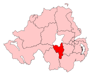
County Armagh is one of the six counties of Northern Ireland and one of the traditional thirty-two counties of Ireland. It is located in the province of Ulster and adjoins the southern shore of Lough Neagh. It borders the Northern Irish counties of Tyrone to the west and Down to the east. The county borders Louth and Monaghan to the south and southwest, which are in the Republic of Ireland. It is named after its county town, Armagh, which derives from the Irish Ard Mhacha, meaning "Macha's height". Macha was a sovereignty goddess in Irish mythology and is said to have been buried on a wooded hill around which the town of Armagh grew. County Armagh is colloquially known as the "Orchard County" because of its many apple orchards.
Lurgan is a town in County Armagh, Northern Ireland, near the southern shore of Lough Neagh and roughly 18 miles (29 km) southwest of Belfast. The town is linked to Belfast by both the M1 motorway and the Belfast–Dublin railway line. Lurgan had a population of about 28,634 at the 2021 UK census, and falls within the Armagh, Banbridge and Craigavon district. For certain purposes, Lurgan is treated as part of the "Craigavon Urban Area", along with neighbouring Craigavon and Portadown.
Armagh is the county town of County Armagh and a city in Northern Ireland, as well as a civil parish. It is the ecclesiastical capital of Ireland – the seat of the Archbishops of Armagh, the Primates of All Ireland for both the Roman Catholic Church and the Church of Ireland. In ancient times, nearby Navan Fort was a pagan ceremonial site and one of the great royal capitals of Gaelic Ireland. Today, Armagh is home to two cathedrals and the Armagh Observatory, and is known for its Georgian architecture.
Upper Bann is a parliamentary constituency in Northern Ireland, which is represented in the United Kingdom House of Commons. The current MP is Carla Lockhart (DUP)
Armagh Observatory is an astronomical research institute in Armagh, Northern Ireland. Around 25 astronomers are based at the observatory, studying stellar astrophysics, the Sun, Solar System astronomy and Earth's climate.
Armagh City and District Council was a district council in County Armagh in Northern Ireland. It merged with Banbridge District Council and Craigavon Borough Council in May 2015 under local government reorganisation in Northern Ireland to become Armagh, Banbridge and Craigavon District Council.
Banbridge was a local government district in Northern Ireland. The district was one of 26 council areas formed on 1 October 1973, following the implementation of the Local Government Act 1972. The headquarters of the council were in the town of Banbridge. In April 2015, most of the Banbridge district was included in the merged Armagh, Banbridge and Craigavon district. Some smaller areas in the east of the district became merged with the Newry, Mourne and Down District
Craigavon Borough Council was a local council in counties Armagh, Down and Antrim, in Northern Ireland. It merged with Armagh City and District Council and Banbridge District Council in May 2015 under local government reorganisation in Northern Ireland to become Armagh, Banbridge and Craigavon District Council.
Richard Robinson, 1st Baron Rokeby, was an Anglo-Irish churchman.
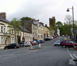
Richhill is a large village and townland in County Armagh, Northern Ireland. It lies between Armagh and Portadown. It had a population of 2,738 people in the 2021 Census.
Mary Dolores Kelly is an Irish nationalist former politician who served as deputy leader of the Social Democratic and Labour Party (SDLP) politician from 2011 to 2015. She was a Member of the Northern Ireland Assembly (MLA) for Upper Bann from 2003 until 2016, and again from 2017 until 2022.
John Baptist Crozier was a Church of Ireland bishop. He served as Bishop of Ossory, Ferns and Leighlin (1897–1907), Bishop of Down, Connor and Dromore (1907–1911), Primate of All Ireland and Archbishop of Armagh (1911–1920).
The Diocese of Dromore is a Latin Church diocese of the Catholic Church in Northern Ireland. It is one of eight suffragan dioceses which are subject to the Metropolitan Archdiocese of Armagh.
Banbridge is a town in County Down, Northern Ireland. It lies on the River Bann and the A1 road and is named after a bridge built over the River Bann in 1712. It is situated in the civil parish of Seapatrick and the historic barony of Iveagh Upper, Upper Half. The town began as a coaching stop on the road from Belfast to Dublin and thrived from Irish linen manufacturing. The town was home to the headquarters of the former Banbridge District Council. Following a reform of local government in Northern Ireland in 2015, Banbridge became part of Armagh City, Banbridge and Craigavon Borough Council. It had a population of 17,400 in the 2021 census.
Craigavon Area Hospital is a large teaching hospital in Portadown, Craigavon, County Armagh, Northern Ireland. It is the main Hospital in the South of Northern Ireland and serves an estimated 241,000 people from the boroughs/districts of Craigavon, Banbridge, Armagh and Dungannon–South Tyrone. It is managed by the Southern Health and Social Care Trust and is located within the townland of Lisnisky, beside the A27 road, at the north-eastern edge of Portadown.
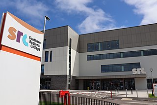
Southern Regional College (SRC) is a further and higher education college in the southern area of Northern Ireland in the United Kingdom. It was formed in 2007 following a merger of the Further Education colleges of Armagh College, Newry and Kilkeel Institute, and the Upper Bann Institute. The College has a total of 5 campuses incorporating the two council areas of Armagh, Banbridge and Craigavon and Newry, Mourne and Down.
Armagh City, Banbridge and Craigavon is a local government district in Northern Ireland. The district was created as Armagh, Banbridge and Craigavon on 1 April 2015 by merging the City and District of Armagh, Banbridge District and most of the Borough of Craigavon. The word "City" was added to the name on 24 February 2016, to reflect Armagh's city status. The local authority is Armagh City, Banbridge and Craigavon Borough Council.
Banbridge District Council was the local authority of Banbridge in Northern Ireland. It was created in 1973 when the Local Government (Boundaries) Act 1971 came into force. In May 2015, it merged with Armagh City and District Council and Craigavon Borough Council to form one of 11 new local government units. The new council area was named Armagh, Banbridge and Craigavon District Council.
The Southern Health and Social Care Trust provides health and social care services in Northern Ireland. It runs Craigavon Area Hospital, Daisy Hill Hospital in Newry, Lurgan Hospital and South Tyrone Hospital as well as Armagh Community Hospital and St Luke's Hospital in Armagh. The trust serves an estimated population of 380,312.
This page is based on this Wikipedia article Text is available under the CC BY-SA 4.0 license; additional terms may apply. Images, videos and audio are available under their respective licenses.