Arkoma, Oklahoma

Last updated

Arkoma, Oklahoma
OKMap-doton-Arkoma.PNG
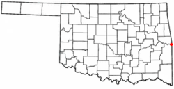
Location of Arkoma, Oklahoma
USA Oklahoma location map.svg
Red pog.svg
Arkoma
Usa edcp location map.svg
Red pog.svg
Arkoma
Coordinates: 35°20′15″N94°26′38″W / 35.33750°N 94.44389°W / 35.33750; -94.44389
Country United States
State Oklahoma
County LeFlore
Area
[1]
  Total3.52 sq mi (9.11 km2)
  Land3.47 sq mi (9.00 km2)
  Water0.04 sq mi (0.12 km2)
Elevation
[2]
423 ft (129 m)
Population
 (2020)
  Total1,806
  Density519.86/sq mi (200.75/km2)
Time zone UTC-6 (Central (CST))
  Summer (DST) UTC-5 (CDT)
ZIP code
74901
Area codes 539/918
FIPS code 40-02650 [3]
GNIS feature ID2411644 [2]

Arkoma is a town in LeFlore County, Oklahoma, United States. It is part of the Fort Smith, Arkansas-Oklahoma Metropolitan Statistical Area. The population was 1,989 at the 2010 census, a decline from 2,180 in 2000. The name of the town is a portmanteau of Arkansas and Oklahoma. Throughout its history, Arkoma has served as a "bedroom community" because many residents commuted to work in Fort Smith. [4]

Contents

History

The community of Arkoma was established circa 1911 on land owned by Captain James Reynolds, a Civil War veteran who had married into the Choctaw Nation. He chose to turn his property into a suburb of Fort Smith. He built houses to rent. He persuaded the Fort Smith Light and Traction Company to construct tracks and operate an electric trolley route to his new community. The streetcar line ceased operating in 1917. [4]

Arkoma was incorporated as a town in 1946.

Geography

Arkoma is located on the same side of the Arkansas River as Fort Smith, Arkansas, [4] and is bounded by the Poteau River to the west and north, and the Arkansas-Oklahoma state line to the east.

According to the United States Census Bureau, the town has a total area of 3.6 square miles (9.3 km2), of which 3.5 square miles (9.1 km2) is land and 0.1 square miles (0.26 km2) (2.23%) is water.

Arkoma enjoys a temperate climate with often mild winters and hot summers.

Demographics

Historical population
CensusPop.Note
1950 1,691
1960 1,86210.1%
1970 2,09812.7%
1980 2,1753.7%
1990 2,39310.0%
2000 2,180−8.9%
2010 1,989−8.8%
2020 1,806−9.2%
U.S. Decennial Census [5]

As of the census of 2010, there were 1,989 people living in the town. [6] The population density was 620.7 inhabitants per square mile (239.7/km2). There were 975 housing units at an average density of 277.6 per square mile (107.2/km2). The racial makeup of the town was 89.22% White, 0.41% African American, 5.78% Native American, 0.32% Asian, 0.87% from other races, and 3.39% from two or more races. Hispanic or Latino of any race were 1.83% of the population.

There were 877 households, out of which 28.4% had children under the age of 18 living with them, 50.4% were married couples living together, 13.5% had a female householder with no husband present, and 32.0% were non-families. 28.6% of all households were made up of individuals, and 10.5% had someone living alone who was 65 years of age or older. The average household size was 2.43 and the average family size was 2.97.

In the town, the population was spread out, with 24.6% under the age of 18, 8.8% from 18 to 24, 25.9% from 25 to 44, 25.8% from 45 to 64, and 15.0% who were 65 years of age or older. The median age was 38 years. For every 100 females, there were 96.8 males. For every 100 females age 18 and over, there were 90.9 males.

The median income for a household in the town was $23,718, and the median income for a family was $31,500. Males had a median income of $24,200 versus $17,104 for females. The per capita income for the town was $13,467. About 17.0% of families and 20.1% of the population were below the poverty line, including 26.8% of those under age 18 and 18.0% of those age 65 or over.

Related Research Articles

<span class="mw-page-title-main">LeFlore County, Oklahoma</span> County in Oklahoma, United States

LeFlore County is a county along the eastern border of the U.S state of Oklahoma. As of the 2020 census, the population was 48,129. Its county seat is Poteau. The county is part of the Fort Smith metropolitan area and the name honors a Choctaw family named LeFlore. The United States District Court for the Eastern District of Oklahoma is the federal district court with jurisdiction in LeFlore County.

<span class="mw-page-title-main">Cedarville, Arkansas</span> City in Arkansas, United States

Cedarville is a city in Crawford County, Arkansas, United States. It is part of the Fort Smith, Arkansas-Oklahoma Metropolitan Statistical Area. The population was 1,410 at the 2020 census.

<span class="mw-page-title-main">Dyer, Arkansas</span> City in Arkansas, United States

Dyer is a city in Crawford County, Arkansas, United States. It is part of the Fort Smith, Arkansas-Oklahoma Metropolitan Statistical Area. The population was 876 at the 2010 census.

<span class="mw-page-title-main">Rudy, Arkansas</span> Town in Arkansas, United States

Rudy is a town in Crawford County, Arkansas, United States. It is part of the Fort Smith, Arkansas-Oklahoma Metropolitan Statistical Area. As of the 2020 Census the population was 130. The population was 72 at the 2000 census.

<span class="mw-page-title-main">Cameron, Oklahoma</span> Town in Oklahoma, United States

Cameron is a town in Le Flore County, Oklahoma, United States. It is part of the Fort Smith, Arkansas-Oklahoma Metropolitan Statistical Area. The population was 302 at the 2010 census, a decline of 3.2 percent from the figure of 312 recorded in 2000.

<span class="mw-page-title-main">Cowlington, Oklahoma</span> Town in Oklahoma, United States

Cowlington is a town in LeFlore County, Oklahoma. It is part of the Fort Smith metropolitan area. The population was 155 at the time of the 2010 census, a gain of 16.5 percent over the figure of 133 recorded in 2000.

<span class="mw-page-title-main">LeFlore, Oklahoma</span> Town in Oklahoma, United States

LeFlore is a town in LeFlore County, Oklahoma, United States. It is part of the Fort Smith, Arkansas-Oklahoma Metropolitan Statistical Area. The population was 198 at the 2010 census, an increase of 13.1 percent over the figure of 168 in 2000. Although the legal town name is spelled in the two-word form, the official federal name for the place and the postal name used is Leflore.

<span class="mw-page-title-main">Pocola, Oklahoma</span> Town in Oklahoma, United States

Pocola is a town in Le Flore County, Oklahoma, United States. It is part of the Fort Smith, Arkansas-Oklahoma metropolitan area. The population was 4,056 in 2010, a gain of 1.6 percent over the figure of 3,994 recorded in 2000. Pocola is a Choctaw word meaning "ten", the approximate distance in miles from Fort Smith, Arkansas.

<span class="mw-page-title-main">Rock Island, Oklahoma</span> Town in Oklahoma, United States

Rock Island is a town in Le Flore County, Oklahoma, United States. It is part of the Fort Smith, Arkansas-Oklahoma Metropolitan Statistical Area. The population was 646 at the 2010 census, a decline of 8.9 percent from the figure of 709 recorded in 2000.

<span class="mw-page-title-main">Brushy, Oklahoma</span> CDP in Oklahoma, United States

Brushy is a census-designated place (CDP) in Sequoyah County, Oklahoma, United States, along U.S. Route 59 in the foothills of the Brushy Mountains. It is part of the Fort Smith, Arkansas-Oklahoma Metropolitan Statistical Area. The population was 900 at the 2010 census, an increase of 14.4 percent over the figure of 787 recorded in 2000.

Carlisle is a census-designated place (CDP) in Sequoyah County, Oklahoma, United States. It is part of the Fort Smith, Arkansas-Oklahoma Metropolitan Statistical Area. The population was 606 at the 2010 census.

<span class="mw-page-title-main">Gans, Oklahoma</span> Town in Oklahoma, United States

Gans is a town in Sequoyah County, Oklahoma, United States. It is part of the Fort Smith, Arkansas-Oklahoma Metropolitan Statistical Area. The population was 312 at the 2010 census, an increase of 50 percent over the figure of 208 recorded in 2000.

<span class="mw-page-title-main">Long, Oklahoma</span> CDP in Oklahoma, United States

Long is a census-designated place (CDP) in Sequoyah County, Oklahoma, United States. It is part of the Fort Smith, Arkansas-Oklahoma Metropolitan Statistical Area. The population was 363 at the 2000 census.

<span class="mw-page-title-main">Moffett, Oklahoma</span> Town in Oklahoma, United States

Moffett is a town in Sequoyah County, Oklahoma, United States. It is part of the Fort Smith, Arkansas-Oklahoma Metropolitan Statistical Area. The population was 128 at the 2010 census, a decline of 28.5 percent from the figure of 179 recorded in 2000.

<span class="mw-page-title-main">Notchietown, Oklahoma</span> CDP in Oklahoma, United States

Notchietown is a census-designated place (CDP) in Sequoyah County, Oklahoma, United States. It is part of the Fort Smith, Arkansas-Oklahoma Metropolitan Statistical Area. The population was 430 at the 2000 census.

<span class="mw-page-title-main">Paradise Hill, Oklahoma</span> Town in Oklahoma, United States

Paradise Hill is a town in the northwest corner of Sequoyah County, Oklahoma, United States. It is part of the Fort Smith, Arkansas-Oklahoma Metropolitan Statistical Area. The population was 85 at the 2010 census, a decline from the figure of 100 recorded in 2000.

<span class="mw-page-title-main">Roland, Oklahoma</span> Town in Oklahoma, United States

Roland is a town in Sequoyah County, Oklahoma, United States. It is part of the Fort Smith, Arkansas-Oklahoma Metropolitan Statistical Area. The population was 3,169 at the 2010 census, compared to the figure of 2,842 recorded in 2000.

Stony Point is a census-designated place (CDP) in Sequoyah County, Oklahoma, United States. It is part of the Fort Smith, Arkansas-Oklahoma Metropolitan Statistical Area. The population was 177 at the 2000 census.

Sycamore is a census-designated place (CDP) in Sequoyah County, Oklahoma, United States. It is part of the Fort Smith, Arkansas-Oklahoma Metropolitan Statistical Area. The population was 150 at the 2000 census.

<span class="mw-page-title-main">Fanshawe, Oklahoma</span> Town in Oklahoma, United States

Fanshawe is a town in Latimer and Le Flore counties in the U.S. state of Oklahoma. As of the 2020 Census, the town had a total population of 317. The Le Flore County portion of Fanshawe is part of the Fort Smith, Arkansas-Oklahoma Metropolitan Statistical Area.

References

  1. "ArcGIS REST Services Directory". United States Census Bureau. Retrieved September 20, 2022.
  2. 1 2 U.S. Geological Survey Geographic Names Information System: Arkoma, Oklahoma
  3. "U.S. Census website". United States Census Bureau . Retrieved January 31, 2008.
  4. 1 2 3 Larry O'Dell, "Arkoma", Encyclopedia of Oklahoma History and Culture. Accessed March 20, 2015.
  5. "Census of Population and Housing". Census.gov. Retrieved June 4, 2015.
  6. "2010 City Population and Housing Occupancy Status". U.S. Census Bureau. Retrieved October 18, 2013.[ dead link ]