Charleston County is located in the U.S. state of South Carolina along the Atlantic coast. As of the 2020 census, the population was 408,235, making it the third most populous county in South Carolina. Its county seat is Charleston. It is also the largest county in the state by land area. The county was created in 1800 by an act of the South Carolina State Legislature.
The StonoRebellion was a slave revolt that began on 9 September 1739, in the colony of South Carolina. It was the largest enslaved rebellion in the Southern Colonies, with 25 colonists and 35 to 50 Africans killed. The uprising was led by native Africans who were likely from the Central African Kingdom of Kongo, as the rebels were Catholic and some spoke Portuguese.

The Ashley River is a blackwater and tidal river in South Carolina, rising from the Wassamassaw and Great Cypress Swamps in western Berkeley County. It consolidates its main channel about five miles west of Summerville, widening into a tidal estuary just south of Fort Dorchester. The river then flows for approximately 17 mi (27 km) along the historical banks of the City of North Charleston before reaching peninsular Charleston. The much wider Ashley joins the Cooper River off the Battery in Charleston to form Charleston Harbor before discharging into the Atlantic Ocean. As of 2012 the land around the Ashley River is mostly undeveloped.

This is a list of the properties and historic districts in each of the 46 counties of South Carolina that are designated National Register of Historic Places.

Drayton Hall is an 18th-century plantation house located on the Ashley River about 15 miles (24 km) northwest of Charleston, South Carolina, and directly across the Ashley River from North Charleston, west of the Ashley in the Lowcountry. An example of Palladian architecture in North America and the only plantation house on the Ashley River to survive intact through both the Revolutionary and Civil wars, it is a National Historic Landmark.

Johns Island is an island in Charleston County, South Carolina, United States, and is the largest island in the state of South Carolina. Johns Island is bordered by the Wadmalaw, Seabrook, Kiawah, Edisto, Folly, and James islands; the Stono and Kiawah rivers separate Johns Island from its border islands. It is the fourth-largest island on the US east coast, surpassed only by Long Island, Mount Desert Island and Martha's Vineyard. Johns Island is 84 square miles (220 km2) in area, with a population of 21,500.

South Carolina Highway 61 (SC 61) is a 67-mile-long (108 km) state highway in the U.S. state of South Carolina. The highway is designated on a north–south direction, but physically travels in an east–west direction, from SC 30 in Charleston to U.S. Route 78 (US 78) near Branchville. The portion of SC 61 from Church Creek Bridge and 10 miles (16 km) north is designated a National Scenic Byway.

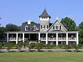
Magnolia Plantation and Gardens is a historic house with gardens located on the Ashley River at 3550 Ashley River Road west of Ashley, Charleston County, South Carolina. It is one of the oldest plantations in the South, and listed on the National Register of Historic Places. Magnolia Plantation is located near Charleston and directly across the Ashley River from North Charleston. The house and gardens are open daily; an admission fee is charged.

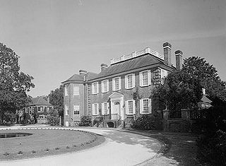
Middleton Place is a plantation in Dorchester County, along the banks of the Ashley River west of the Ashley and about 15 miles (24 km) northwest of downtown Charleston, in the U.S. state of South Carolina. Built in several phases during the 18th and 19th centuries, the plantation was the primary residence of several generations of the Middleton family, many of whom played prominent roles in the colonial and antebellum history of South Carolina. The plantation, now a National Historic Landmark District, is used as a museum, and is home to the oldest landscaped gardens in the United States.

West Ashley, or more formally, west of the Ashley, is one of the six distinct areas of the city proper of Charleston, South Carolina. As of July 2022, its estimated population was 83,996. Its name is derived from the fact that the land is west of the Ashley River.

Hopsewee Plantation, also known as the Thomas Lynch, Jr., Birthplace or Hopsewee-on-the-Santee, is a plantation house built in 1735 near Georgetown, South Carolina. It was the birthplace of Thomas Lynch, Jr., a Founding Father who was a signer of the Declaration of Independence, and served as a Lowcountry rice plantation. Before he departed for his ill-fated voyage he made a will, which stipulated that heirs of his female relatives must change their surname to Lynch in order to inherit the family estate, a rice plantation. He was taken ill at the end of 1779 and he sailed, with his wife, for St. Eustatius in the West Indies. Their ship disappeared at sea in a storm and was never found. The family estate, Hopsewee, still stands in South Carolina. The Lynch family sold the house in 1752 to Robert Hume whose son, John Hume, lived at Hopsewee in the winter after inheriting it. Upon his death in 1841, his own son, John Hume Lucas, inherited the house. John Hume Lucas died in 1853. Like many Santee plantations, it was abandoned during the Civil War. After the war, rice was never planted again, but the Lucas family continued to occupy Hopsewee until 1925. In September 1949, Col. and Mrs. Wilkinson bought the house and occupied it.

The High Hills of Santee, sometimes known as the High Hills of the Santee, is a long, narrow hilly region in the western part of Sumter County, South Carolina. It has been called "one of the state's most famous areas". The High Hills of Santee region lies north of the Santee River and east of the Wateree River, one of the two rivers that join to form the Santee. It extends north almost to the Kershaw county line and northeasterly to include the former summer resort town of Bradford Springs. Since 1902 the town has been included in Lee County.

This is a list of the National Register of Historic Places listings in Charleston County, South Carolina.
The Coastal Carolina Council is the Boy Scouts of America council that services much of the South Carolina Lowcountry. It operates 6 districts and two scout camps—Camp Ho Non Wah and Camp Moultrie.
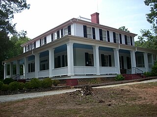
The Fenwick Hall, which is also known as Fenwick Castle, is a plantation house built about 1730 on Johns Island, South Carolina, across the Stono River from James Island and Charleston. It is located between River Road and Penneys Creek. It was named to the National Register of Historic Places on February 23, 1972.
Ashtabula is a plantation house at 2725 Old Greenville Highway near Pendleton in Anderson County, South Carolina, USA. It has been also known as the Gibbes-Broyles-Latta-Pelzer House or some combination of one or more of these names. It was named in the National Register of Historic Places as a historic district on March 23, 1972. It is considered a significant example of a Lowcountry style plantation house built for a Charleston family in the Upstate in the early 19th century. It also is part of the Pendleton Historic District.

Saint Andrew's Parish Church is located in Charleston, South Carolina, along the west side of the Ashley River. Built in 1706 it is the oldest surviving church building south of Virginia. Its historic graveyard dates from the church's establishment. Expanded in 1723 into the shape of a cross, the church is the only remaining colonial cruciform church in South Carolina. In 1973 it was placed on the National Register of Historic Places. Old St. Andrew's, as it is commonly called, remains an active place of worship and is affiliated with the Anglican Diocese of South Carolina and the Anglican Church in North America.

William Bull was a colonial American landowner and politician in the Province of South Carolina.

Ashley Hall Plantation is a historic plantation complex located on the Ashley River near West Ashley, Charleston County, South Carolina. The plantation was established in the early 1670s by Stephen Bull. The property includes a small tabby-walled house with a 20th-century second story addition, the ruins of the Georgian plantation house (1704) which was burned in 1865 to prevent its destruction by Union forces, a monument to the second Governor William Bull, two prehistoric Indian archaeological sites, and two 18th century well sites associated with the plantation. The tabby house is considered one of the oldest standing houses in the state.
John Grimké Drayton was a nineteenth-century planter and priest in Charleston, South Carolina. He was a horticulturalist at Magnolia Plantation and Gardens on the Ashley River and an Episcopal priest who served nearby Old St. Andrew's Parish Church for forty years.