Portsmouth is a city in Rockingham County, New Hampshire, United States. At the 2020 census it had a population of 21,956. A historic seaport and popular summer tourist destination on the Piscataqua River bordering the state of Maine, Portsmouth was formerly the home of the Strategic Air Command's Pease Air Force Base, since converted to Portsmouth International Airport at Pease.

Kittery Point is a census-designated place (CDP) in the town of Kittery, York County, Maine, United States. First settled in 1623, Kittery Point traces its history to the first seafarers who colonized the shore of what became Massachusetts Bay Colony and later the State of Maine. Located beside the Atlantic Ocean, it is home to Fort McClary State Historic Site, and Fort Foster Park on Gerrish Island. Cutts Island is home to Seapoint Beach and the Brave Boat Harbor Division of the Rachel Carson National Wildlife Refuge.
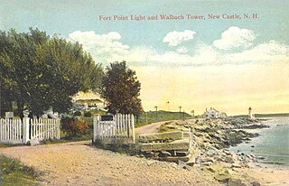
New Castle is a town in Rockingham County, New Hampshire, United States. The population was 1,000 at the 2020 census. It is the smallest and easternmost town in New Hampshire, and the only one located entirely on islands. It is home to Fort Constitution Historic Site, Fort Stark Historic Site, and the New Castle Common, a 31-acre (13 ha) recreation area on the Atlantic Ocean. New Castle is also home to a United States Coast Guard station, as well as the historic Wentworth by the Sea hotel.

The Portsmouth Naval Shipyard, often called the Portsmouth Navy Yard, is a United States Navy shipyard in Kittery on the southern boundary of Maine near the city of Portsmouth, New Hampshire.

Kittery is a town in York County, Maine, United States. Home to the Portsmouth Naval Shipyard on Seavey's Island, Kittery includes Badger's Island, the seaside district of Kittery Point, and part of the Isles of Shoals. The southernmost town in the state, it is a tourist destination known for its many outlet stores.
The Piscataqua River is a 12-mile-long (19 km) tidal river forming the boundary of the U.S. states of New Hampshire and Maine from its origin at the confluence of the Salmon Falls River and Cochecho River to the Atlantic Ocean. The drainage basin of the river is approximately 1,495 square miles (3,870 km2), including the subwatersheds of the Great Works River and the five rivers flowing into Great Bay: the Bellamy, Oyster, Lamprey, Squamscott, and Winnicut.

Fort McClary is a former defensive fortification of the United States military located along the southern coast at Kittery Point, Maine at the mouth of the Piscataqua River. It was used throughout the 19th century to protect approaches to the harbor of Portsmouth, New Hampshire and the Portsmouth Naval Shipyard in Kittery. The property and its surviving structures are now owned and operated by the State of Maine as Fort McClary State Historic Site, including a blockhouse dating from 1844.

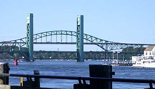
The Sarah Mildred Long Bridge is a lift bridge spanning the Piscataqua River between Portsmouth, New Hampshire, and Kittery, Maine, carrying traffic of U.S. Route 1 Bypass. An original bridge by the same name was in operation from 1940 until 2016. A replacement span opened in March 2018.
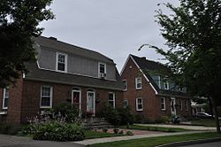
Hilton Village is a planned English-village-style neighborhood in Newport News, Virginia. Recognized as a pioneering development in urban planning, it is listed on the National Register of Historic Places. The neighborhood was built between 1918 and 1921 in response to the need for housing during World War I for employees of Newport News Shipbuilding & Drydock Company. It is recognized as the United States' first Federal war-housing project.

Seavey's Island, site of the Portsmouth Naval Shipyard, is located in the Piscataqua River in Kittery, Maine, United States, opposite Portsmouth, New Hampshire. It encompasses 278 acres (1.13 km2).

The Piscataqua River Bridge is a through arch bridge that crosses the Piscataqua River, connecting Portsmouth, New Hampshire with Kittery, Maine, United States. Carrying six lanes of Interstate 95, the bridge is the third modern span and first fixed crossing of the Piscataqua between Portsmouth and Kittery. The two other spans, the Memorial Bridge and the Sarah Mildred Long Bridge, are both lift bridges, built to accommodate ship traffic along the Piscataqua. The high arch design of the Piscataqua River Bridge eliminates the need for a movable roadway.

Highland Heights–Stevens' Subdivision Historic District is a residential historic district located in Highland Park, Michigan along five east-west streets: Farrand Park, McLean Street, Colorado Street, Rhode Island Street, and Massachusetts Street, between Woodward Avenue on the west and Oakland Avenue on the east. The district was listed on the National Register of Historic Places in 1988.

Badger's Island is located in the Piscataqua River at Kittery, Maine, United States, directly opposite Portsmouth, New Hampshire. It carries U.S. Route 1 between the states, connecting to the Kittery mainland by the Badger's Island Bridge, and to New Hampshire by the Memorial Bridge. Now largely a suburb of Portsmouth, the island features houses, condominiums, restaurants and marinas.
The Harriman Historic District is located in the northern section of Bristol, Pennsylvania, United States. It is a 17-acre (6.9 ha) residential area with 109 buildings, mostly houses, and the local secondary school.
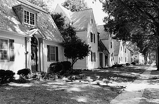
Christeele Acres Historic District is a residential subdivision in Orem, Utah, built in 1943 as housing for workers at the Geneva Steel plant during World War II. The historic district includes 62 single-family houses and three duplexes. The houses were built to Federal Housing Administration (FHA) "minimum house" standards, which were considered to be the minimum size of a house necessary for a family with three persons or a family with two small children. The houses had two bedrooms and approximately 700 square feet (65 m2) of living space.

Fairview, originally named Yorkship Village, is a neighborhood located in southern Camden, in Camden County, in the U.S. state of New Jersey. According to the 2000 United States census, Fairview Village has a population of 5,947. Much of the neighborhood is part of a historic district listed on the state and federal registers of historic places.

Kilham & Hopkins was an architectural firm in Boston, Massachusetts formed in 1899 or 1900 by its founding members, Walter Harrington Kilham and James Cleveland Hopkins. The firm later became Kilham, Hopkins & Greeley after William Roger Greeley joined the firm in 1916, and Kilham Hopkins Greeley and Brodie after Walter S. (Steve) Brodie joined the firm in 1945.

The Kittery Community Center is located in the former Frank C. Frisbee Elementary School at 120 Rogers Road in Kittery, Maine. The building, built in 1943 by the United States government as part of war-related expansions of Portsmouth Naval Shipyard, was listed on the National Register of Historic Places in 2015 for this association. It served Kittery as a school until 2009, and was converted for use as a multi-function community center providing space for arts, culture, and recreational activities in 2011-12.
Helen "Eileen" Foley was an American politician. Foley served as the Mayor of Portsmouth, New Hampshire, eight terms from 1968–1971, 1984–1985, and 1988–1997. She remains the longest-serving mayor in the city's history. She represented the 24th District in the New Hampshire Senate for seven terms, including one term as the Democratic Party Minority Leader.

The Portsmouth Downtown Historic District encompasses the historic urban core of Portsmouth, New Hampshire. With a history dating to the 17th century, Portsmouth was New Hampshire's principal seaport and the center of its economy for many decades, and the architecture of its urban center is reflective of nearly four centuries of history. The district is roughly L-shaped, radiating from the downtown Market Square area to South Street in the south and Madison and Columbia streets in the west, with more than 1,200 historically significant buildings. It was listed on the National Register of Historic Places in 2017. The district includes 35 previous listings on the National Register, and five National Historic Landmarks.