Fort William and Mary was a colonial fortification in Britain's worldwide system of defenses, defended by soldiers of the Province of New Hampshire who reported directly to the royal governor. The fort, originally known as "The Castle," was situated on the island of New Castle, New Hampshire, at the mouth of the Piscataqua River estuary. It was renamed Fort William and Mary circa 1692, after the accession of the monarchs William III and Mary II to the British throne. It was captured by Patriot forces, recaptured, and later abandoned by the British in the Revolutionary War. The fort was renamed Fort Constitution in 1808 following rebuilding. The fort was further rebuilt and expanded through 1899 and served actively through World War II.

Horse Sand Fort is one of the larger Royal Commission sea forts in the Solent off Portsmouth, Hampshire, England. The fort is one of four built as part of the Palmerston Forts constructions. It is 200 feet (61 m) across, built between 1865 and 1880, with two floors and a basement and armour-plated all round.

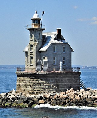
Race Rock Light is a lighthouse on Race Rock Reef, a dangerous set of rocks on Long Island Sound southwest of Fishers Island, New York and the site of many shipwrecks. It is currently owned and maintained by the New London Maritime Society as part of the National Historic Lighthouse Preservation Act program.
Appledore Island is the largest of the Isles of Shoals located about seven miles off the Maine coast. It is part of the Town of Kittery, in York County.

The Sharps Island Light is the third lighthouse to stand nearly 3 miles (5 km) south-southwest from the southern end of Tilghman Island in Maryland's Chesapeake Bay. The structure is best known today for evoking the Leaning Tower of Pisa, a condition caused by an ice floe in 1977.

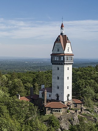
The 165-foot-tall (50 m) Heublein Tower is located in Talcott Mountain State Park in Simsbury, Connecticut, United States and provides panoramic views of the Hartford skyline, the Farmington River Valley, and surrounding areas that are particularly spectacular in the fall. It was listed on the National Register of Historic Places in 1983.
The Rio Grande Ranch Headquarters Historic District is a historic one-story residence located 3 miles (4.8 km) east of Okay in Wagoner County, Oklahoma. The site was listed on the National Register of Historic Places September 9, 1992. The site's Period of Significance is 1910 to 1935, and it qualified for listing under NRHP criteria A and C.

The Alger Theater is a theatre located at 16451 East Warren Avenue in the MorningSide neighborhood of Detroit, Michigan. It is one of only two remaining intact and unchanged neighborhood theaters in the city of Detroit. It was listed on the National Register of Historic Places in 2005.

Odiorne Point State Park is a public recreation area located on the Atlantic seacoast in the town of Rye near Portsmouth, New Hampshire, in the United States. Among the park's features are the Seacoast Science Center and the remains of the World War II Fort Dearborn. The park offers opportunities for hiking, cycling, picnicking, fishing, and boating.

The Greenfield Meeting House is a historic meeting house on Forest Road in the center of Greenfield, New Hampshire. The two-story wood-frame building was built in 1795; it is one of a small number of 18th century meeting houses in New Hampshire, and is believed to be the oldest still used for both religious and secular purposes, hosting both church services and town functions. The building was listed on the National Register of Historic Places in 1983.

The County Farm Bridge is a historic stone arch bridge in Wilton, New Hampshire. Built in 1885, it carries Old County Farm over Whiting Brook, just south of its northern junction with Burton Highway in a rural section of northwestern Wilton. It is an unusually late and well-preserved example of a 19th-century stone arch bridge, and was listed on the National Register of Historic Places in 1981.

The South Meetinghouse is a historic ward hall at 260 Marcy Street in Portsmouth, New Hampshire. Completed in 1866, it is one of the city's finest examples of Italianate architecture, and a rare surviving example of a 19th-century ward hall. The building was listed on the National Register of Historic Places in 1982. It continues to be used as a community resource.

St. Andrew's-by-the-Sea is a historic Episcopal chapel on Church Road, southeast of the junction with South Road and Route 1A in Rye, New Hampshire. Built in 1876, it is the only known religious work of Boston architects Winslow & Wetherell, and one of a modest number of churches built for summer vacationers in the state. It is an eclectic mix of Gothic Revival and Stick Style, and was listed on the National Register of Historic Places in 2001.

Battery 223 is in Lower Township, Cape May County, New Jersey, United States. The harbor defense battery was completed in 1943. It was added to the National Register of Historic Places on June 25, 2008.

Garrison Hill Tower is a 76-foot-tall (23 m) observatory atop Garrison Hill in Dover, New Hampshire, United States. The current tower, made of iron and painted green, was built in 1993 and is the third tower to exist on the hill. The park in which it stands is listed on the National Register of Historic Places.

The Verde River Sheep Bridge, also known as the Red Point Sheep Bridge, is a suspension bridge which crosses the Verde River in Arizona. Constructed primarily to allow sheep to be driven between grazing ranges on either side of the river. Building started in 1943 and was completed in 1944. Sheep drives stopped in 1978. The bridge was closed in 1987 and largely demolished in 1988. A replica bridge was constructed by the U.S. Forest Service in 1989 to allow hikers access to the Mazatzal Wilderness in Tonto National Forest. The original west suspension tower still remains alongside the replica bridge.

The Ogilvie Watertower is a historic water tower in Ogilvie, Minnesota, United States, built in 1918. It was listed on the National Register of Historic Places in 1980 for having local significance in the themes of engineering and social history. It was nominated for being a rare surviving example of Minnesota's earliest reinforced concrete water towers and a symbol of the local infrastructure improvements that enabled the organization of Ogilvie's fire department.
The Harbor Defenses of Portsmouth was a United States Army Coast Artillery Corps harbor defense command. It coordinated the coast defenses of Portsmouth, New Hampshire and the nearby Portsmouth Naval Shipyard in Kittery, Maine from 1900 to 1950, both on the Piscataqua River, beginning with the Endicott program. These included both coast artillery forts and underwater minefields. The command originated circa 1900 as the Portsmouth Artillery District, was renamed Coast Defenses of Portsmouth in 1913, and again renamed Harbor Defenses of Portsmouth in 1925.

The Keweenaw Waterway Lower Entrance Light, also known as the Portage Entry Light, is a lighthouse located at the south end of breakwater at mouth of the Portage River in Torch Lake Township. It was listed on the National Register of Historic Places in 2014.

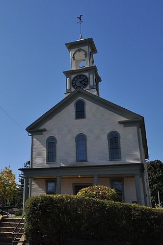
Rye Town Hall is a historic town hall located at 10 Central Road in Rye, New Hampshire. Constructed in 1839 and purchased by the town in 1873, it was listed on the National Register of Historic Places in 2020, and the New Hampshire State Register of Historic Places in 2013.


