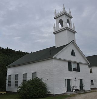
Newington is a town in Rockingham County, New Hampshire, United States. The population was 811 at the 2020 census. It is bounded to the west by Great Bay, to the northwest by Little Bay and to the northeast by the Piscataqua River.

The Seacoast Region is the southeast area of the U.S. state of New Hampshire that is centered around the city of Portsmouth. It includes the eastern portion of Rockingham County and the southern portion of Strafford County. At its narrowest definition, the region stretches 13 miles (21 km) along the Atlantic Ocean from New Hampshire's border with Salisbury, Massachusetts, to the Piscataqua River and New Hampshire's border with Kittery, Maine. The shoreline alternates between rocky and rough headlands and areas with sandy beaches. Some of the beaches are bordered by jetties or groins, particularly in the towns of Rye and Hampton. Most definitions of the Seacoast Region includes some inland towns as well, including the Great Bay area cities of Dover and Rochester, the college town of Durham, and areas as far west as Epping. Some definitions also include nearby portions of York County, Maine that are culturally aligned with the Portsmouth area rather than the Portland, Maine metropolitan area.

The Flanders Historic District is a historic district that encompasses a small cluster of late-18th to early-19th century residential structures north of the center of Kent, Connecticut, United States which was the original heart of the community when it was first settled. It is centered at the junction of U.S. Route 7 with Cobble Road and Studio Hill Road. The area was supplanted by the current town center in the 1840s. The district was listed on the National Register of Historic Places in 1979.

The Sutton Center Historic District is a historic district encompassing the center of the village of Sutton, Massachusetts. The district, which covers 435 acres (176 ha), is centered on the junction of Boston Road, Singletary Avenue, and Uxbridge Road. Boston Road is a major east–west route through the town, and the other two roads run north–south through the village center. The Colombian building was built in 1957. A typically rural village center, its civic and institutional buildings are clustered near the intersection on its south side, in the general area of the town common. The town common and cemetery were laid out in 1719, after settlement of the township began in 1716. There are a few surviving houses that date to the middle of the 18th century or earlier; exact dates for most are uncertain. There are only a few institutional buildings: the 1829 Congregational Church, the 1983 Town Hall, built on the site of the town's first purpose-built town hall (1885), and Rufus Putnam Hall, an 1824 school building and Masonic lodge that now houses the local history museum. Only one commercial structure the 1839 Brick Block, stands in the village. There is also a historic animal pound, a rectangular stone structure used to pen stray livestock, which dates to the early days of the town.
The Old Town Center Historic District is a historic district roughly along Locust Public Rd. and Salt Pond Road in Eastham, Massachusetts. The district encompasses Eastham's original town center, with a cluster of well-preserved 18th- and 19th-century buildings. The area served as the town's civic center due to its proximity to Salt Pond, which provided access to the Atlantic Ocean, and was a major transportation route. The advent of the railroad in the 1870s shifted the town's economic and civic heart to the present center. The Old Town district is 40 acres (16 ha) in size, with 42 mainly residential buildings contributing to its significance. The oldest building in the district is the c. 1672 John Knowles House at 191 Locust Road. The town's first town hall (1851) and first schoolhouse (1869) still stand in the district; the schoolhouse is a landmark visible from Route 6.

The Hadley Center Historic District is an expansive, 2,500-acre (1,000 ha) historic district encompassing the village center of Hadley, Massachusetts. When it was first listed on the National Register of Historic Places in 1977, the district encompassed the town green and 17 buildings that faced it, at the junction of Russell Street and Middle Street. The district was expanded significantly in 1994, adding more than 400 buildings representative of the village's growth from colonial days into the first decades of the 20th century. This expansion encompasses the entirety of a tongue of land extending west from East Street and bounded by a bend in the Connecticut River, which separates Hadley from Northampton. Its oldest property, the Samuel Porter House on West Street, was built in 1713.

The Boston Post Road Historic District encompasses a portion of the historic roadway known as the Boston Post Road, which ran Boston, Massachusetts to Albany, New York. The surviving alignment in Weston, Massachusetts extends along the entire length of United States Route 20, except for a bypassed section that passes through the town's village center. The 3.5 miles (5.6 km) of roadway retains much of the generally rural appearance it had during the late colonial period, and the town center retains significant elements of historic character as well. The district was added to the National Register of Historic Places in 1983.

The Front Street Historic District in Exeter, New Hampshire, encompasses a portion of the town's historic center. The district extends from Swasey Pavilion, at the junction of Front and Water streets, southwesterly along Front Street to Gale Park, about five blocks. Front Street is one of Exeter's oldest roads, and is lined with a series of 18th and 19th-century civic, religious, and residential structures, many of which are well preserved. The district was listed on the National Register of Historic Places (NRHP) in 1973.

Newington Junction is a section of the town of Newington, Connecticut, United States. It is centered at the intersection of Willard Avenue and West Hill Road in the northwestern part of the town, in the area generally just south of the Hartford city line. The name of the area refers to the railroad junction where the railroad line from New Haven meets with the railroad line from Bristol and Waterbury. The development of Newington Junction as a result of the railroad was instrumental in the separation of the town of Newington from its mother town of Wethersfield.

The Hollis Village Historic District encompasses the historic village center of Hollis, New Hampshire. The district is centered on Monument Square, which connects Main Street to Depot Street and Broad Street. It covers about 400 acres (160 ha), and extends along all three of those roads for some distance, and includes properties on Silver Lake Road and Ash Street. Most of the buildings in the district are residential or agricultural in use, and date before the turn of the 20th century; the oldest buildings date to the mid-18th century. The "Always Ready Engine House", which occupies a triangular parcel at the western end of Monument Square, was built in 1859, and is the town's oldest municipal building. Its most architecturally sophisticated building is the town hall, built in 1887 to a design by William M. Butterfield of Manchester. The district represents the growth of a mainly agricultural community over a 200-year period. The district was listed on the National Register of Historic Places in 2001.
Lamson Farm is a historic farm property on Lamson Road in Mont Vernon, New Hampshire. Founded in the 1770s and operated as a farm until 1975, it is one of the few surviving intact 19th-century farm properties in the community. Its land, over 300 acres (120 ha) in size, is now town-owned conservation and farmland. The property has trails open to the public, and an annual celebration of Lamson Farm Day is held here every September. The property was added to the National Register of Historic Places in 1981.

The East Andover Village Center Historic District encompasses the historic village center of East Andover, New Hampshire, United States. The 2.2-acre (0.89 ha) district includes a cemetery and three buildings: the Andover Congregational Church, the Highland Lake Grange Hall, and the East Andover Schoolhouse. It is located at the corner of New Hampshire Route 11 and Chase Hill Road. The district is unified by the appearance of the three buildings, and their styling, which is predominantly vernacular 19th century.
The Colburn Park Historic District encompasses the heart of Lebanon, New Hampshire. It consists of Colburn Park, a large rectangular park in the center of the city, the buildings that are arrayed around it, and several 19th century buildings that are immediately adjacent to those. The district covers 12 acres (4.9 ha), and was listed on the National Register of Historic Places in 1986.

The Plymouth Historic District encompasses a cluster of five civic buildings and the town common of Plymouth, New Hampshire, United States. The buildings are arrayed on the west side of Plymouth's town common, laid out not long after the town's settlement in 1763. The 2-acre (0.81 ha) district includes the town hall/court house, the Pemigewasset National Bank building, and the US Post Office building, as well as the Old Grafton County Courthouse. The Plymouth Congregation Church also falls within the district bounds, but is not considered contributing. The district was listed on the National Register of Historic Places in 1986.

The Covit House is a historic house on Goshen Center Road in Goshen, New Hampshire. Built about 1800, it is one of the oldest surviving and best-preserved plank-frame houses in the town. The house was listed on the National Register of Historic Places in 1985.
The Newington Railroad Depot is a historic railroad station on Bloody Point Road in Newington, New Hampshire. Built in 1873, it is an unusual railroad-related structure, serving as a passenger and freight depot, and as the residence of the stationmaster, who also performed the role of toll collector for the nearby bridge. It is the only surviving 19th-century railroad-related structure in Newington. Now vacant and owned by the state, the building was listed on the National Register of Historic Places in 2010.
The Washington Common Historic District encompasses a cluster of three civic buildings and the town common in the center of Washington, New Hampshire. The town common began as a 2-acre (0.81 ha) parcel acquired in 1787, and the current town hall followed in 1789. It is a two-story wood-frame building which originally served as both a civic and religious meeting house. The adjacent Gothic Revival Congregational Church was built in 1840. The third structure is the Schoolhouse, a 2+1⁄2-story two-room school built in 1883. The district was listed on the National Register of Historic Places in 1986.
The Barnet Center Historic District encompasses a small cluster of buildings and a cemetery, which make up the original town center of Barnet, Vermont. Located on Barnet Center Road, it includes the 1849 Presbyterian church, vestry, and two residences, built between 1790 and 1898, as well as the town's first cemetery and a c. 1915 toolshed. It was the first town in Vermont to be settled by direct immigration from Scotland. The district was listed on the National Register of Historic Places in 1984.

The Francestown Town Hall and Academy and Town Common Historic District encompasses a collection of historic 18th and 19th-century civic resources in the center of Francestown, New Hampshire. Located at the junction of New Boston and Greenfield Roads are the town's 1846 Greek Revival town hall and academy building, a former academic dormitory building, and the town's historic common, which includes a rare example of an early 20th-century platform scale. The district was listed on the National Register of Historic Places in 2016.

The Portsmouth Parade Historic District is an area in Portsmouth, New Hampshire, which was formerly listed in the National Register of Historic Places (NRHP). The district is known locally as "The Hill", a cluster of closely spaced historic houses bounded on the north by Deer Street and the east by High Street at the northern edge of downtown Portsmouth. The grouping was created by a road widening project, from houses originally located on or near Deer Street.