Portsmouth is a city in Rockingham County, New Hampshire, United States. At the 2020 census it had a population of 21,956. A historic seaport and popular summer tourist destination on the Piscataqua River bordering the state of Maine, Portsmouth was formerly the home of the Strategic Air Command's Pease Air Force Base, since converted to Portsmouth International Airport at Pease.

The Seacoast Region is the southeast area of the U.S. state of New Hampshire that is centered around the city of Portsmouth. It includes the eastern portion of Rockingham County and the southern portion of Strafford County. At its narrowest definition, the region stretches 13 miles (21 km) along the Atlantic Ocean from New Hampshire's border with Salisbury, Massachusetts, to the Piscataqua River and New Hampshire's border with Kittery, Maine. The shoreline alternates between rocky and rough headlands and areas with sandy beaches. Some of the beaches are bordered by jetties or groins, particularly in the towns of Rye and Hampton. Most definitions of the Seacoast Region includes some inland towns as well, including the Great Bay area cities of Dover and Rochester, the college town of Durham, and areas as far west as Epping. Some definitions also include nearby portions of York County, Maine that are culturally aligned with the Portsmouth area rather than the Portland, Maine metropolitan area.
William Berry was the first settler at Sandy Beach, Rye, New Hampshire.

Downtown Norfolk serves as the traditional center of commerce, government, and culture in the Hampton Roads region. Norfolk, Virginia's downtown waterfront shipping and port activities historically played host to numerous and often noxious port and shipping-related uses. With the advent of containerized shipping in the mid-19th century, the shipping uses located on Norfolk's downtown waterfront became obsolete as larger and more modern port facilities opened elsewhere in the region. The vacant piers and cargo warehouses eventually became a blight on downtown and Norfolk's fortunes as a whole. But in the second half of the century, Norfolk had a vibrant retail community in its suburbs; companies like Smith & Welton, High's, Colonial Stores, Goldman's Shoes, Lerner Shops, Hofheimer's, Giant Open Air, Dollar Tree and K & K Toys were regional leaders in their respective fields. Norfolk was also the birthplace of Econo-Travel, now Econo Lodge, one of the nation's first discount motel chains.

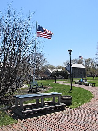
Strawbery Banke is an outdoor history museum located in the South End historic district of Portsmouth, New Hampshire. It is the oldest neighborhood in New Hampshire to be settled by Europeans, and the earliest neighborhood remaining in the present-day city of Portsmouth. It features more than 37 restored buildings built between the 17th and 19th centuries in the Colonial, Georgian, and Federal style architectures. The buildings once clustered around a waterway known as Puddle Dock, which was filled in around 1900. Today the former waterway appears as a large open space.

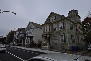
The North Bedford Historic District is a historic district roughly bounded by Summer, Parker, Pleasant and Kempton Streets in New Bedford, Massachusetts. It encompasses a predominantly residential neighborhood north of downtown New Bedford which was developed primarily in the mid 19th-century. It features a variety of worker housing of the period, as well as a number of higher quality houses built by businessmen. The district was added to the National Register of Historic Places in 1979.

A gundalow is a type of flat-bottomed sailing barge once common in Maine and New Hampshire rivers, United States. It first appeared in the mid-1600s, reached maturity of design in the 1700 and 1800s, and lingered into the early 1900s before nearly vanishing as a commercial watercraft.

The Front Street Historic District in Exeter, New Hampshire, encompasses a portion of the town's historic center. The district extends from Swasey Pavilion, at the junction of Front and Water streets, southwesterly along Front Street to Gale Park, about five blocks. Front Street is one of Exeter's oldest roads, and is lined with a series of 18th and 19th-century civic, religious, and residential structures, many of which are well preserved. The district was listed on the National Register of Historic Places (NRHP) in 1973.

Old North Cemetery is a historic cemetery on Maplewood Avenue in Portsmouth, New Hampshire. It is a roughly 1.5-acre (0.61 ha) parcel of land north of the city center on the shore of North Mill Pond. Its earliest burials are dated to 1751, although it was not formally established as a cemetery until 1753. It is the largest of the city's 18th century cemeteries, and is remarkable for the relatively distant locations some of the stonecarvers came from whose work appears in it. The cemetery was listed on the National Register of Historic Places in 1978.

St. John's Church is a historic church at 101 Chapel Street in Portsmouth, New Hampshire, United States. The brick building was designed by Alexander Parris and built in 1807; it was the first brick church in the state of New Hampshire, and is a rare surviving early design by Parris. The building was listed on the National Register of Historic Places in 1978. The church is home to an Episcopal congregation organized in 1732, with roots in the city's 17th-century founding.

The Atlantic Heights Development is a historic company-built worker subdivision in Portsmouth, New Hampshire. Bounded by I-95, the Piscataqua River, and the tracks of the Boston and Maine Railroad, this small neighborhood was built in 1918–1920 to meet housing demand for workers at the Atlantic Company Shipyard, located just to the south, and served as a prototype for later residential subdivisions. It was listed on the National Register of Historic Places in 2006.

Prescott Park is a ten-plus acre waterfront park in Portsmouth, New Hampshire, United States. The land was purchased in the 1930s by two sisters, Josie and Mary Prescott. The sisters, public school teachers, had used an inheritance to systematically purchase and clear properties along the Piscataqua River. The sisters' goal was to create a public waterfront park, free and accessible to all, replacing what had become a run-down and seedy industrial area. In 1949 the Prescott sisters' trust was established with $500,000. The park was willed to the city of Portsmouth in 1954 for public enjoyment.

The Exeter Waterfront Commercial Historic District encompasses the historic commercial and residential waterfront areas of Exeter, New Hampshire. The district extends along the north side of Water Street, roughly from Main Street to Front Street, and then along both sides of Water and High streets to the latter's junction with Portsmouth Street. It also includes properties on Chestnut Street on the north side of the Squamscott River. This area was where the early settlement of Exeter took place in 1638, and soon developed as a shipbuilding center. The district was listed on the National Register of Historic Places in 1980. It was enlarged in 1986 to include the mill complex of the Exeter Manufacturing Company on Chestnut Street.

The Newmarket Industrial and Commercial Historic District encompasses the heart of a distinctive 19th century mill town, Newmarket, New Hampshire. Its mill complex is regionally distinctive for its extensive use of stone from an early date, and the town is relatively well-preserved due to a significant economic decline after the mills closed in 1920. The district was listed on the National Register of Historic Places in 1980. The Stone School, listed in 1978, is a contributing resource.

The Portsmouth Cottage Hospital was the first hospital built in the city of Portsmouth, New Hampshire. Opened in 1884, it was one of the first hospitals in New Hampshire, and it served as the city's primary hospital facility until 1986, when Portsmouth Regional Hospital opened. Its 1895 campus has been repurposed to house city offices and the police station, and a senior living facility. A portion of that facility, representing its oldest buildings, was listed on the National Register of Historic Places in 1996.

The Shapley Town House, also known as the Reuben Shapley House, is a historic house at 454-456 Court Street in Portsmouth, New Hampshire. Built about 1815, it is unusual in the city as a particularly well-preserved example of a Federal period double house. The house was listed on the National Register of Historic Places in 1973. It is owned by the Strawbery Banke Foundation.

The Dorset Village Historic District encompasses a significant portion of the village center of Dorset, Vermont. Centered at the junction of Church Street, Kent Hill Road, and Vermont Route 30, the village was developed between the late 18th and early 20th centuries, and has a number of well-preserved unusual features, including sidewalks of marble from local quarries. The district was listed on the National Register of Historic Places in 1985, and was enlarged to the west in 1997.

The Battery Street Historic District encompasses one of the oldest developed areas of Burlington, Vermont. With a history dating to 1790, this area, south of downtown Burlington and initially bounded roughly by Main, St. Paul, and Maple Streets, and Lake Champlain, this area includes a mix of residential, commercial, and industrial uses, with architecture spanning from its early period to the 20th century, including one of the city's oldest houses. The district was listed on the National Register of Historic Places in 1977, and has twice been enlarged, extending west to South Union Street.

The Buell Street–Bradley Street Historic District encompasses a small residential area just to the east of downtown Burlington, Vermont. Roughly bounded by Pearl, South Willard, and College Streets, and Orchard Terrace, the area was developed between about 1890 and 1910, representing one of the last significant neighborhoods built up near the downtown area. The district was listed on the National Register of Historic Places in 1995.

The Joshua Wentworth House is an historic building in Portsmouth, New Hampshire, which was formerly individually listed in the National Register of Historic Places (NRHP). The building was again listed in 1975 as a contributing resource to the Strawbery Banke Historic District, and is a contributing resource to the Portsmouth Downtown Historic District placed on the NRHP in 2017.


