The Amherst Central Business District is a historic district encompassing the heart of downtown Amherst, Massachusetts. Centered on the northern section of the long town common, the area has been the civic and commercial heart of the town since the 18th century. The district was listed on the National Register of Historic Places in 1991, and slightly enlarged in 2011.

The Lunenburg Historic District is a historic district encompassing the historic center of Lunenburg, Massachusetts. The district is centered on a stretch of Main Street which connects two triangular intersections. It includes many of the town's oldest buildings, including the c. 1724 Cushing House, and the c. 1730 Stillman Stone House. Three of the town's most significant institutional buildings were built before 1850: the town hall, the Congregational church, and the Methodist church. The district was added to the National Register of Historic Places in 1988.

The Gardner Uptown Historic District is a historic district encompassing the former civic heart of Gardner, Massachusetts. The 65-acre (26 ha) area includes the old town common, an early cemetery, and a modest number of non-residential buildings among a larger number of houses. The area was the center of civic life from the incorporation of Gardner in 1785 until municipal functions were moved to West Gardner beginning in the late 1920s. The district was listed on the National Register of Historic Places in 1999.

The Center Village District encompasses the historic village center of Lancaster, Massachusetts. Settled in 1643, it has few traces of its early history, but is now a well-kept rural town center with a predominantly residential and civic character. It includes the First Church of Christ, Lancaster, which is a U.S. National Historic Landmark, and was listed on the National Register of Historic Places in 1977.

The Hatfield Center Historic District encompasses the traditional center of Hatfield, Massachusetts. The area, first laid out in 1661, is bounded by Maple Street to the south, the Connecticut River to the east, Day Avenue and School Street to the north, and the Mill River to the west. The area's layout and land use patterns are relatively little altered since they were laid out, leaving a well-preserved early colonial village landscape. The district was added to the National Register of Historic Places in 1994.

The Bradford Common Historic District is a historic district encompassing the former town center of Bradford, now a village of Haverhill, Massachusetts. Centered on the former town common at South Main and Salem Streets, the area served as Bradford's civic and commercial center from about 1750 until its annexation by Haverhill in 1897, and retains architecture from the 18th to early 20th centuries. It was added to the National Register of Historic Places in 1977.

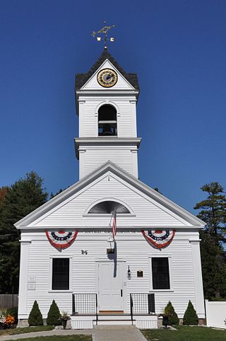
The Amherst Village Historic District encompasses the historic village center of Amherst, New Hampshire. Centered on the town's common, which was established about 1755, Amherst Village is one of the best examples of a late-18th to early-19th century New England village center. It is roughly bounded on the north by Foundry Street and on the south by Amherst Street, although it extends along some roads beyond both. The western boundary is roughly Davis Lane, the eastern is Mack Hill Road, Old Manchester Road, and Court House Road. The district includes the Congregational Church, built c. 1771-74, and is predominantly residential, with a large number of Georgian, Federal, and Greek Revival houses. Other notable non-residential buildings include the Farmer's Bank, a Federal-style brick building built in 1806, and the Amherst Brick School, a brick Greek Revival structure that has served as the School Administrative Unit 39 offices since 1997.

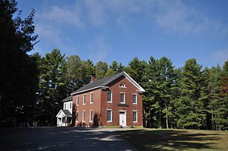
The Lyme Center Historic District encompasses a modest crossroads and industrial village in rural Lyme, New Hampshire. The predominantly residential district stretches along Dorchester Road, on either side of its junction with Baker Hill Road. The village's rise in development started in the early 19th century as it was at a crossroads of the east-west Dorchester Road, and the north-south Baker Hill Road and Acorn Hill Road. The village grew rapidly in the 1820s, with a number of simple Greek Revival houses, and in 1830 the Baptist Church was built. The other major civic building in the village is the Lyme Academy, built in 1839, albeit with more Federal than Greek Revival styling. Grant Brook, which runs parallel to Dorchester Road, provided a source of power for the growth of small industrial efforts, including a sawmill at the corner of Dorchester and Baker Hill Roads. This industry provided a second minor building boom in the late 19th to early 20th century. Most of the houses in the district are vernacular Greek Revival or Cape in their styling; probably the most elaborate Greek Revival house is the 1857 Beal-Pike House at 41 Dorchester Road.

The Jewell Town District of South Hampton, New Hampshire, encompasses a colonial-era industrial village with a history dating to 1687. It is centered at the junction of West Whitehall and Jewell Streets, which is just south of a bend in the Powwow River, the source of the power for the mills that were built here. The area was settled in 1687 by Thomas Jewell, and by the early 19th century included a variety of mills as well as a bog iron works. The district now includes only remnants of its industrial past, and features a collection of 18th and early-19th century residential architecture. The district was listed on the National Register of Historic Places in 1983.

The Kensington Town House is the town hall of Kensington, New Hampshire. Located at 95 Amesbury Road, the single-story wood-frame building was erected in 1846, and has been its only purpose-built municipal hall. It is a good local example of civic Greek Revival architecture, and its hall has historically hosted town meetings and social functions. The building was listed on the National Register of Historic Places in 2013.
The Little Boar's Head Historic District encompasses an area of summer resort and beachfront properties in North Hampton, New Hampshire. Located on New Hampshire's seacoast roughly between North Hampton State Beach and Bass Beach, the district is almost entirely residential, consisting mainly of houses built as summer vacation spots in the late 19th and early 20th centuries, with associated beachfront amenities. The district was listed on the National Register of Historic Places in 1999.
The Newington Center Historic District encompasses the historic civic heart of Newington, New Hampshire. It consists of a section of Nimble Hill Road between its junction with Little Bay Road, and a gate at the southern end marking the start of territory formerly associated with Pease Air Force Base. This area includes the town common, laid out in 1640, a cluster of civic buildings, and several private residences, as well as remnants of the state's oldest town forest. The district was listed on the National Register of Historic Places in 1987; in 1991 an additional 69 acres (28 ha) of former town forest, now part of the airfield, were added to the district.
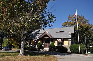
The Old North Hampton Library is a historic library building at 237 Atlantic Avenue in North Hampton, New Hampshire. The small, single-story Tudor Revival structure was designed by Boston architect J. Lawrence Berry and built in 1907. It was the town's first purpose-built library building, and was used as such until a new library was built nearby in 1973. It presently houses town offices. The building was listed on the National Register of Historic Places in 2014, and the New Hampshire State Register of Historic Places in 2013.
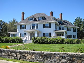
The North Hampton Town Hall is located at 231 Atlantic Avenue in North Hampton, New Hampshire. Built in 1844, it was the town's first purpose-built municipal building, and continues to be used as such. Its construction includes materials recovered from older dual-purpose religious and civic buildings, and its tower houses a Revere bell. The building was listed on the National Register of Historic Places in 2013, and the New Hampshire State Register of Historic Places in 2006.

The Smith's Corner Historic District is a historic district encompassing a historic 19th-century rural village center. Covering about 105.5 acres (42.7 ha), the district is centered on the junction of Main Avenue, South Road, and Chase Road in northwestern South Hampton, abutting its border with East Kingston. The village was important as a stagecoach stop. The district was listed on the National Register of Historic Places in 1983.
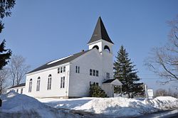
The Washington Common Historic District encompasses a cluster of three civic buildings and the town common in the center of Washington, New Hampshire. The town common began as a 2-acre (0.81 ha) parcel acquired in 1787, and the current town hall followed in 1789. It is a two-story wood-frame building which originally served as both a civic and religious meeting house. The adjacent Gothic Revival Congregational Church was built in 1840. The third structure is the Schoolhouse, a 2+1⁄2-story two-room school built in 1883. The district was listed on the National Register of Historic Places in 1986.

The Woodman Road Historic District of South Hampton, New Hampshire, is a small rural residential historic district consisting of two houses on either side of Woodman Road, a short way north of the state line between New Hampshire and Massachusetts. The Cornwell House, on the west side of the road, is a Greek Revival wood-frame house built c. 1850. Nearly opposite stands the c. 1830 Verge or Woodman House, which is known to have been used as a meeting place for a congregation of Free Will Baptists between 1830 and 1849.

The Fair Haven Green Historic District encompasses the village green of Fair Haven, Vermont, and the heterogeneous collection of civic, commercial, and residential buildings that line it and adjacent streets. The area was developed mainly following the arrival of the railroad in 1848 and the subsequent expansion of marble and slate quarries in the area. The district was listed on the National Register of Historic Places in 1980.

The Wallingford Main Street Historic District encompasses the historic portions of the village of Wallingford, Vermont. An essentially linear district extending along Main Street on either side of School Street, it has a well-preserved array of 19th and early-20th century residential, commercial, and civic buildings. It was listed on the National Register of Historic Places in 1984.
Centennial Hall is a historic community hall and schoolhouse at 105 Post Road in North Hampton, New Hampshire. Built in 1876, it is a distinctive local example of Stick Style architecture, and has served the town as a schoolhouse and community meeting place for most of its existence. It was listed on the National Register of Historic Places in 1980.